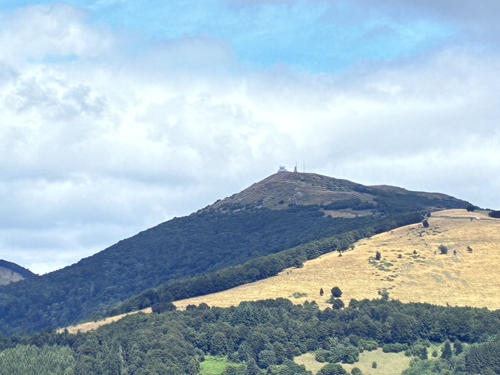
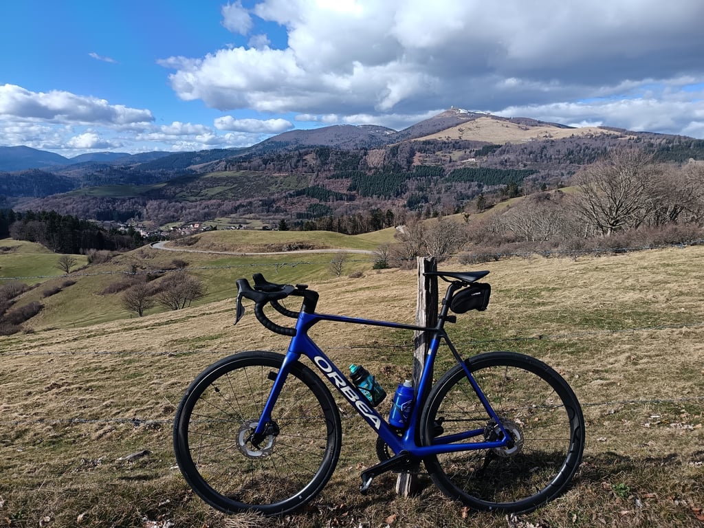
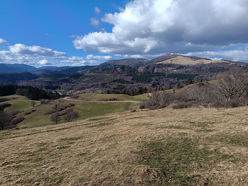
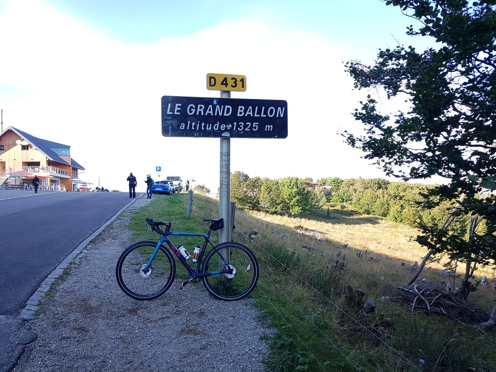
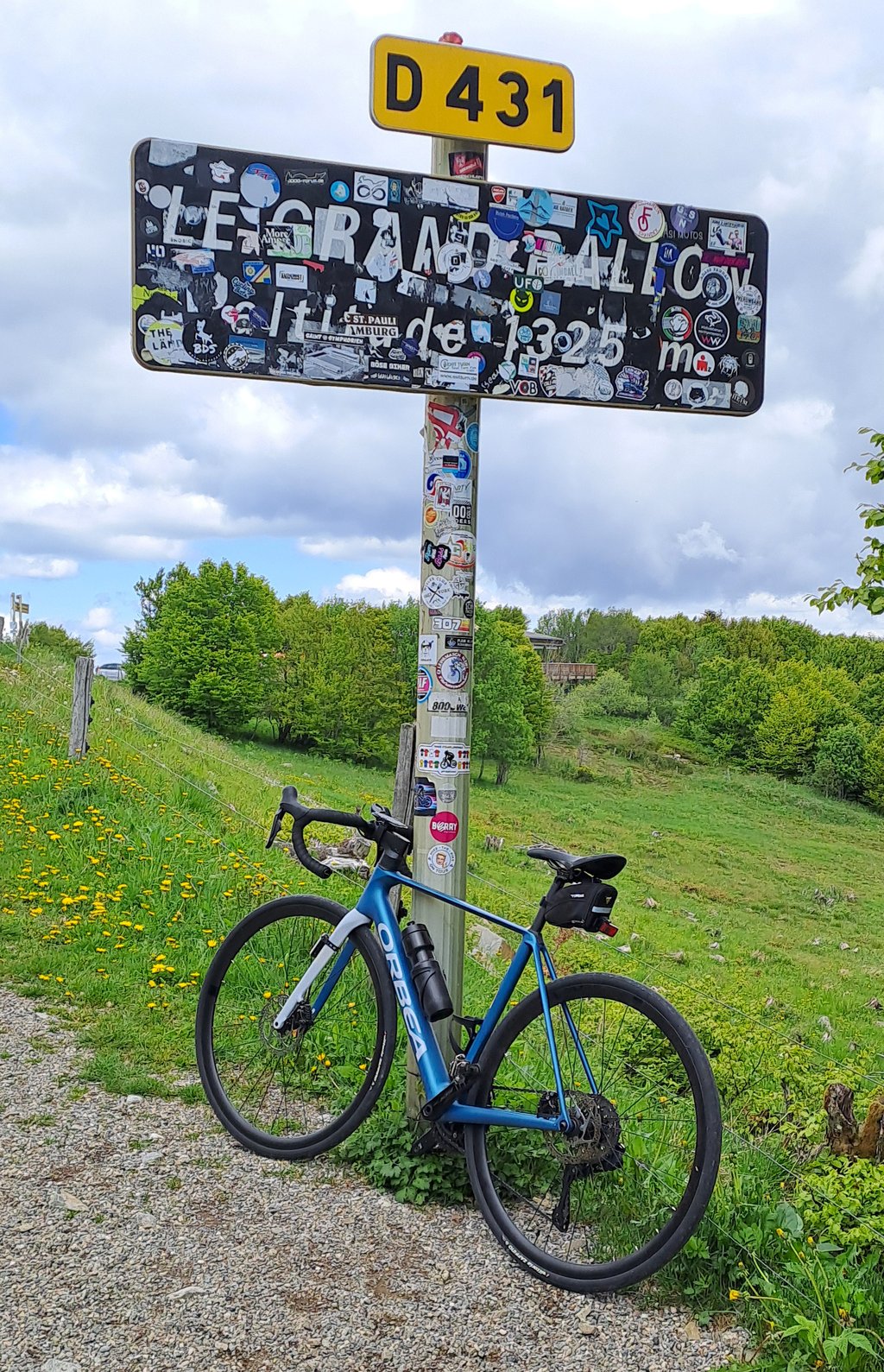
Col du Grand Ballon is a climb in the region Upper Rhine. It is 21.7 km long and bridges 1147 m of vertical ascent with an average gradient of 5.3%, resulting in a difficulty score of 817. The top of the ascent is located at 1341 m above sea level. Climbfinder users shared 42 reviews of this climb and uploaded 70 photos.
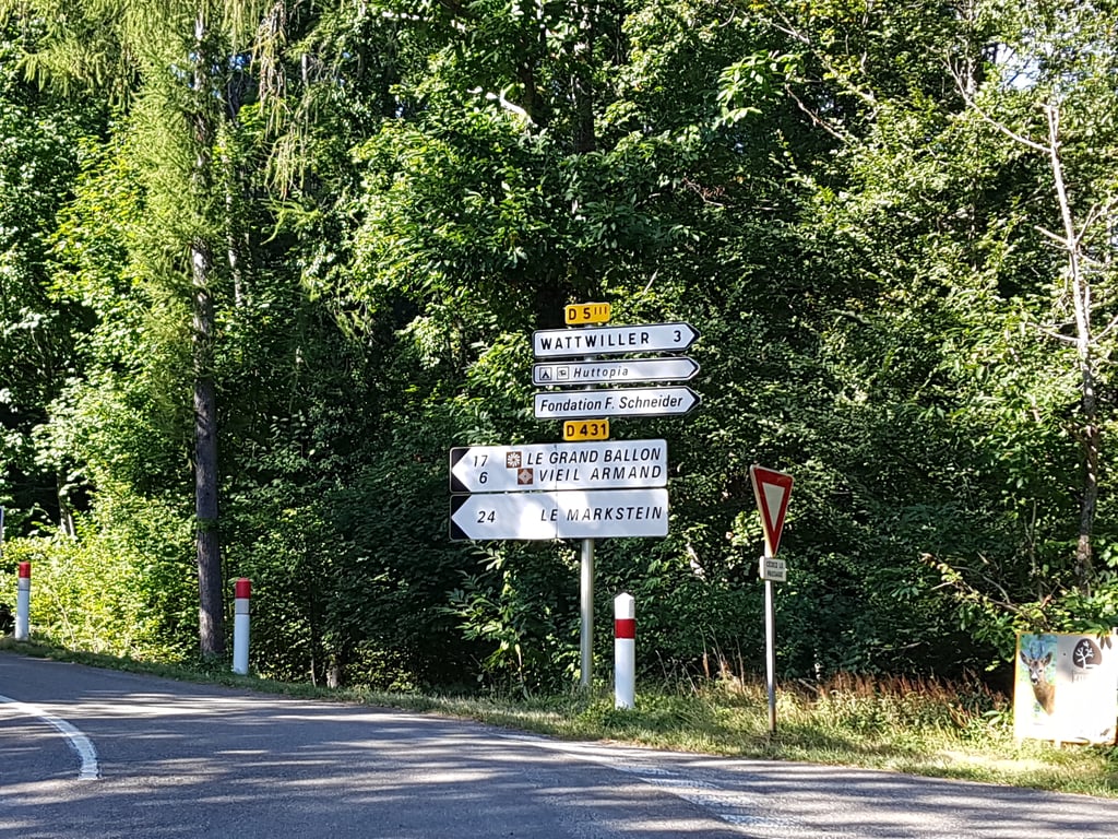
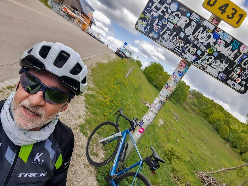
Road name: D431
5.0 by Morgan-TThis is an automatic translation, the original language is: French.Very nice pass. I climbed it during a great bike ride in beautiful weather. Very nice landscapes. Many parts in the forest (at the beginning of the pass), very appreciable during big heats.... read more
Welcome! Please activate your account if you would like to share something. Look for the verification email in your inbox.
If you want to upload your photos, you need to create an account. It only takes 1 minute and it's completely free.
Beautiful mountain, must have done! First time was the higher the worse the weather. Rain, strong wind and fog were the most difficult conditions. Next day in good weather, scenery could be seen, beautiful!
Prachtige berg, moet je gedaan hebben! Eerste keer was hoe hoger, hoe slechter het weer. Regen, harde wind en mist waren de moeilijkste omstandigheden. Volgende dag bij mooi weer was omgeving wel te zien, prachtig!
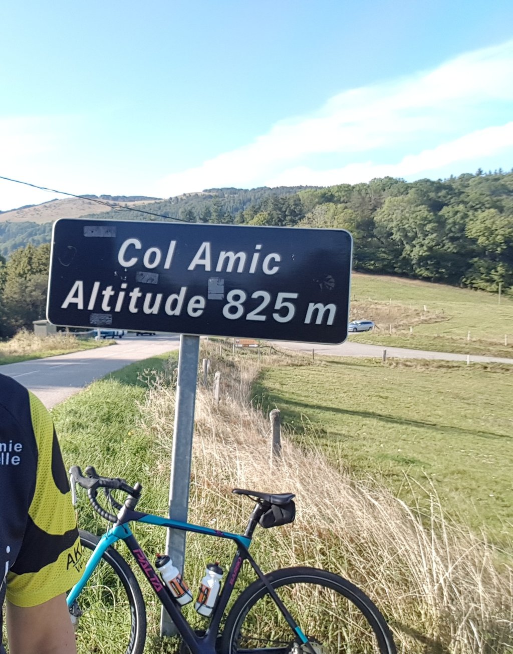
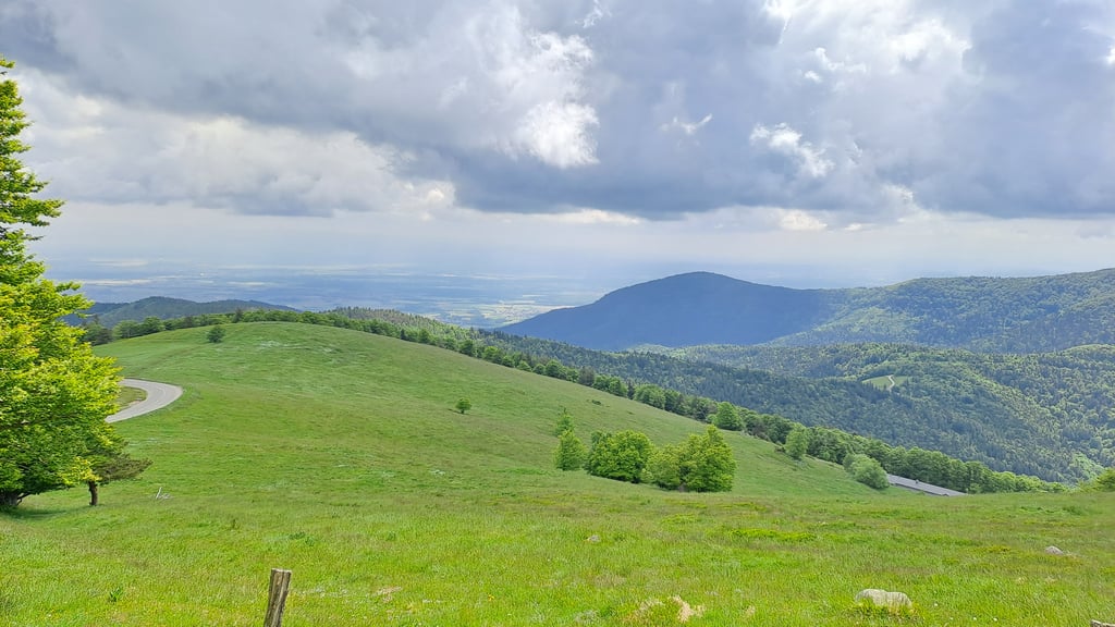
The first half in the forest is almost monotonous, but allows you to find your rhythm and get used to the gradient. The easy descent to Col Amic is really scenic. The last few kilometres up to the Grand Ballon are then quite tough again, but you always have the view up to the radar station, which motivates you to keep going. The length is great, it feels like a short mountain tour.
Die erste Hälfte im Wald ist fast schon eintönig, aber ermöglicht seinen Rythmus zu finden und sich an die Steigung zu gewöhnen. Die leichte Abfahrt zum Col Amic ist landschaftlich wirklich reizvoll. Die letzten Kilometer hoch zum Grand Ballon sind dann nochmal recht hart, aber man hat immer wieder den Blick hoch zur Radarstation, der einen motiviert durchzuziehen. Die Länge ist super, fühlt sich wie eine kleine Bergtour an.
It's my first pass over 1000 D+. I didn't find it very difficult as I climbed slowly.
The road surface is very good and traffic was fairly calm.
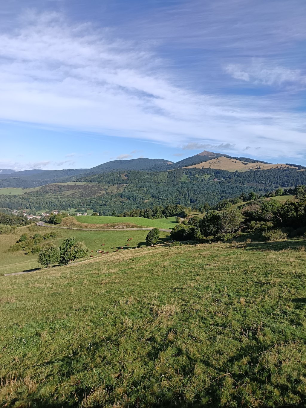
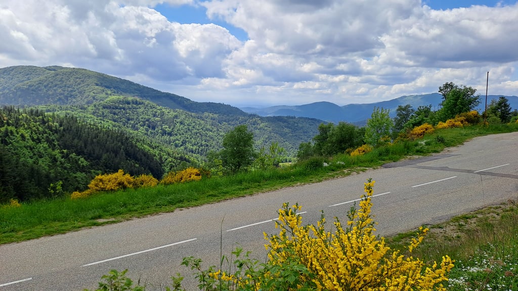
From the Col Amic onwards, the beautiful open countryside begins.
I did it on a rather gloomy May day; beware of the temperature difference between the start and the summit.
This first "big" ascent made me want to try some more difficult ones.
C'est mon premier col de plus de 1000 D+. Je ne l'ai pas trouvé très difficile en montant tranquillement.
La route a un très bon revêtement et la circulation était assez calme.
A partir du col Amic commencent les beaux paysages dégagés.
Je l'ai faite un jour de mai assez maussade; attention à la différence de température entre le départ et le sommet.
Cette première "grosse" ascention m'a donné l'envie d'en tenter des plus difficiles.
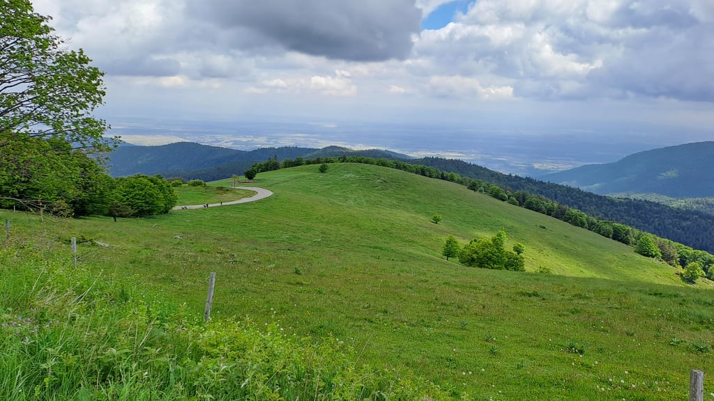
Traditional, tough climb in the Vosges. Is part of the great Route des Cretes. Includes bit of cobblestones. Restaurant on top. On top stunning views towards Black Forest and Alps.
Traditionele, pittige klim in de Vogezen. Maakt deel uit van de geweldige Route des Cretes. Inclusief stukje klinkers. Restaurant bovenop. Bovenop schitterende uitzichten richting Zwarte Woud en Alpen.
Climbed on 15 November! 1°C in Cernay in the fog, then sun above 600 m altitude. The first part is in the forest on a pleasant winding route!
After the central descent, the 2nd part is more difficult, but if you climb at your own pace, you'll reach the summit. The last 2 kilometres are a little easier.
All in all, a demanding climb!
Gravi ce 15 novembre ! 1°C à Cernay sous le brouillard puis du soleil au dessus de 600 m d'altitude. La première partie se fait en forêt dans un parcours sinueux agréable !
Après la descente centrale, la 2ème partie est plus difficile mais en montant à son rythme, on atteint le sommet. Les 2 derniers kilomètres sont un peu plus faciles.
Globalement, une montée exigeante !
Nice climb towards the grand ballon that climbs in two sections. The two climbing sections are regular. After the first bit of climbing, you first have a flat bit and then descend with great views. Be careful though, one tricky bend that turns very back and no view of oncoming traffic. The second bit of climbing is the centre of gravity in the middle section. Weird though that the beautiful tarmac suddenly turns into a small cobbled section.
Mooie beklimming richting de grand ballon die in twee stukken klimt. De twee klimstukken zijn regelmatig. Na het eerste stuk klimmen, heb je eerst een vlak stukje en daarna afdalen met een prachtig uitzicht. Wel oppassen, één tricky bochtje die heel terug keert en geen zicht op aankomend verkeer. De tweede stuk klimmen is het zwaartepunt in het middenstuk. Wel raar dat het mooie asfalt plots verandert in een klein kasseistrookje.
My eighth col. 200 climbfinder points harder than my previous one and yet.... By taking it easy and using the right gear, I got my 105kg to the top without too much pain! It's pretty and not too tricky, at least in the first two thirds. I climbed it on a Wednesday morning in July.
Mon huitième col. 200 points climbfinder plus dur que mon précédent et pourtant.... En y allant tranquillement avec un développement adapté j'ai hissé mes 105 kg au sommet sans trop souffrir! C'est joli et sans trop de passage, du moins dans les deux premiers tiers. Monté un mercredi matin en juillet.
On the last of four days of cycling in the Vosges and Alsace, I was able to cross this climb off my list on Saturday 29 June. Now the climbing in this region is fantastic anyway of course, but there is one thing that sets the Grand Ballon apart from other climbs as far as I'm concerned: during the climb you get a real view of the summit you need to get to. For some, this may be anything but fun (if you are broken), but I find such a view at the summit to have something magical.
The climb itself is, as already described by many more reviewers, a multi-stage rocket. Climb, recover a bit on a flat/false flat/valley section, climb to the top. Good tarmac with some bricks here and there in a hairpin to (I presume) get the speed out for descending bikes. Lots of sections through forest, which is typical of the climbs here. And for people with some cycling fitness in their legs, nowhere a climb that will be too tough.
I would definitely include the climb in your route if you have the chance. Because of the length, the views, the name and fame of the Grand Ballon and the fact that it is not as hard as an Alpine giant. So do it!
Op de laatste van vier dagen fietsen in de Vogezen en Elzas kon ik deze klim op zaterdag 29 juni van mijn lijstje strepen. Nu is het in deze regio sowieso fantastisch klimmen natuurlijk, maar er is wat mij betreft een ding dat de Grand Ballon onderscheidt van andere beklimmingen: je krijgt tijdens de beklimming echt zicht op de top waar je naar toe moet. Voor sommigen wellicht alles behalve een pretje (als je stuk zit), maar ik vind zo'n uitzicht op de top iets magisch hebben.
De klim zelf is, zoals al door veel meer reviewers is beschreven, een meertraps raket. Klimmen, beetje bijkomen op een vlak/vals plat/daal tussenstuk, klimmen tot de top. Goed asfalt met her en der wat klinkers in een haarspeld om (naar ik aanneem) de snelheid eruit te halen voor dalende motoren. Veel stukken door het bos, wat kenmerkend is voor de beklimmingen hier. En voor mensen die wat fietsconditie in de benen hebben nergens een beklimming die te zwaar zal zijn.
Ik zou de klim zeker in je route opnemen als je de kans hebt. Vanwege de lengte, het uitzicht, de naam en faam van de Grand Ballon en het feit dat ie niet zo zwaar is als een Alpenreus. Doen dus!
Tough climb due to the fact that you're climbing for so long. Kind of skewed that descent into it, though. Climbed from three sides so far (Moosch, Soultz and Cernay) and this one is m'n least favourite side. Also quite busy with cars's and motorcyclists.
Zware beklimming door het feit dat je zo lang aan het klimmen bent. Wel een beetje scheef die afdaling erin. Tot nu toe van drie kanten beklommen (Moosch, Soultz en Cernay) en deze is m'n minst favoriete kant. Ook vrij druk met auto's en motorrijders.
Apart at times, but what a beautiful climb! Really enjoyed it! My first real col, after only some Limburg climbs, but this tastes like more. First part climbing from Cernay is mostly through the forest with lots of turns. After about 10 kilometres, you are treated to stunning views of the Grand Ballon. After some false flat and downhill, it's back up for the final 7 kilometres. These are tough, but I found them not too bad. Indeed, unlike the first km's through the forest, you can see where the top is, and thus the redemption 😀. All in all highly recommended!
Afgezien bij vlagen, maar wat een prachtige klim! Echt genoten! Mijn eerste echte col, na alleen wat Limburgse klimmetjes, maar dit smaakt naar meer. Eerste gedeelte klimmen vanuit Cernay is grotendeels door het bos met veel bochten. Na een kilometer of 10 word je getrakteerd op een prachtig uitzicht op de Grand Ballon. Na wat vals plat en afdalen gaat het weer flink omhoog voor de laatste 7 kilometers. Deze zijn pittig, maar ik vond ze meevallen. In tegenstelling tot de eerste km’s door het bos zie je namelijk waar de top is, en dus de verlossing 😀. Al met al dikke aanrader!
One of the first climbs I ever did. Nice long steady climb. This is a nice climb to "learn" to climb as you have a small descent halfway up to recover. Save your strength for the second half as if you ride up the first section too fast, you will notice it on the second harder half.
Een van de eerste klimmen die ik ooit gedaan heb. Mooie lange gelijkmatige klim. Dit is een leuke klim om te “leren” klimmen aangezien je halverwege een kleine afdaling hebt om bij te komen. Bewaar je krachten voor de tweede helft aangezien als je het eerste gedeelte te snel op rijd, je dit zal merken op de tweede zwaardere helft.
Nice long climb, expected it to be tougher. Last part fine to do. I definitely recommend, if you're here you can't skip this one.
Mooie lange klim, had het zwaarder verwacht. Laatste deel prima te doen. Ik zeker een aanrader, als je hier bent kun je deze niet overslaan.
Cernay is a very nice little town that is worth a visit. From there, it's a forest climb to Vieil Armand, a pass that you pick up on the way. The first few kilometres are very busy, with many motorbikes. As the track is rather wide, it wasn't dangerous in my opinion, but boring. From Viel Armand there is a slight descent to Col Armic for ~ 800 m. From there you start a wonderful climb up to Gd Ballon, initially a bit of cobbled road, then wide, good condition streets. As you approach the top, you have a beautiful view, if the weather is good, of the Rhine valley. I rode a Cyclo-cross bike, which was hard because of the length of the climb. Next time I will take the vdc, apart from that and the traffic, it was a wonderful experience.
Cernay est une petite Ville très sympa qui mérite une visite. A partir de là, c'est la montée forestière vers le Vieil Armand, un col qu'on 'ramasse en passant'. Les premiers km sont très fréquentées, bcp. de motocycles. Comme la piste est plutôt large, ce n'était, à mon avis, pas dangereux mais ennuyant. A partir du Viel Armand, il y a une légère descente jusqu'à Col Armic sur ~ 800 m. A partir de là, on commence une montée merveilleuse vers le Gd Ballon, initialement un peu de pavé, puis de larges rues en bon état. Lorsqu'on s'approche du sommet, on a une belle vue, s'il fait beau même de la vallée du Rhin. J'ai fait le trajet avec un vélo Cyclo-cross, ce qui était dur, vu la longueur de la montée. La prochaine fois je prendrais le vdc, à part cela et le trafic, c'était une merveilleuse expérience.
Today (16/9/22) was the 2nd time I climbed this tricky mountain. The 1st time already dates from 6 years ago during the tour 'les 3 Ballons'. It's a climb not to be underestimated, but personally I don't find those last 6-7 kms (after the bit of descent) really any harder than the initial kilometres. Even in that first stretch, my Garmin regularly gave stretches up to 10-12% !!! If you don't force it in the 1st part, you normally also smoothly overcome the 2nd part, where you are spoiled with beautiful views 🤩
Vandaag (16/9/22) was de 2e maal dat ik deze lastigaard beklom. De 1e maal dateert al van 6 jaar geleden tijdens de toertocht ‘les 3 Ballons’. Het is een niet te onderschatten klim, maar persoonlijk vind ik die laatste 6-7 kms (na het stukje afdaling) niet echt lastiger dan de beginkilometers. Ook in dat eerste stuk gaf mijn Garmin regelmatig stukken tot 10-12% aan !! Als je in het 1e stuk niet forceert, dan overwin je normaal gezien ook vlotjes het 2e deel, waar je verwend wordt met prachtige vergezichten 🤩
Beautiful climb with some recovery half way. Last 6km is definitely tough, but all in all this climb is not too bad.
My first col ever and a taste for more
Prachtige beklimming met wat recuperatie halverwege. Laatste 6km is zeker pittig, maar al bij al valt deze klim goed mee.
Mijn eerste col ooit en de smaak naar meer
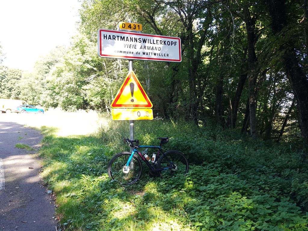
Actually, these are two climbs in one. Not that it matters, but then you know what you are getting into. The first climb is 8 km long and averages just under 7%; the second is 6.5 km and 8%. In between, you stay at roughly the same altitude. You pass a war cemetery on this stretch. On this mountain, the Hartmannswillerkopf, 30,000 soldiers were killed in 1915. If you don't think about it too much, the route is quite boring up to that point. You drive between the trees all the time. The shade is nice, of course, when it is 32 degrees.
On the last, steeper part, you do have beautiful views, wonderful even. Both over the Rhine valley on the east side, and the next mountain range on the east side. If you want to reach the top of the Ballon, you will have to take the footpath, a few hundred metres before the col. That will take you 40 minutes.
When we arrived, it started to cloud over and we saw rain in the distance. So we drove back as quickly as possible. That is also easy. The road surface is quite decent and it is not very busy at the end of June. You see mostly motorbikes. So pay attention if you want to take a wide hairpin bend, because before you know it, there is one right behind you.
All in all, because of the last part, a nice climb. We had planned it as a warm-up, on the way to the Alps, to see if we could still get up against gradients of 7 to 8 percent. Well, we did. Only, the next morning I had a positive coronation test, so it became a short cycling holiday.
Eigenlijk zijn dit twee beklimmingen in één. Niet dat dat uitmaakt, maar dan weet je waar je aan begint. De eerst klim is 8 kilometer lang en gemiddeld net geen 7%; de tweede is 6,5 km en 8%. Daartussen blijf je ruwweg op dezelfde hoogte.
Je komt op dit stuk langs een oorlogskerkhof. Er zijn op die berg, de Hartmannswillerkopf, in 1915 namelijk 30.000 soldaten gesneuveld. Als je daar niet te diep bij nadenkt, is de route tot op dat punt vrij saai. Je rijdt namelijk voortdurend tussen de bomen. De schaduw is natuurlijk wel fijn, als het 32 graden is.
Op het laatste, steilere stuk, heb je wel mooie uitzichten, prachtig zelfs. Zowel over het Rijndal aan de oostkant, als de volgende bergketen aan de oostkant. Als je de top van de Ballon wil bereiken, zul je het voetpad moeten nemen, een paar honderd meter voor de col. Dat kost je 40 minuten.
Toen wij aankwamen, begon het te betrekken en zagen we regenbuien in de verte. We zijn dus zo snel mogelijk weer teruggereden. Dat kan ook makkelijk. Het wegdek is heel behoorlijk en het is eind juni niet echt druk. Je ziet vooral motorfietsen. Even opletten dus, als je een haarspeldbocht ruim wilt nemen, want voor je het weet zit er een vlak achter je.
Al met al vanwege het laatste stuk een leuke klim. We hadden hem gepland als opwarmertje, onderweg naar de Alpen, om toch even te kijken of we nog wel omhoog zouden komen tegen hellingen van 7 à 8 procent. Nou, dat ging dus. Alleen had ik de volgende ochtend een positieve coronatest, waardoor het een korte fietsvakantie is geworden.
Rode it on Thursday, 19-08-21.
During my stay in the Vosges I first chose to climb the Grand Ballon from Cernay then via Willer-sur-Thur and on the last day from Moosch.
The side from Cernay is the most popular and you sometimes see other cyclists cycling in front of you that can serve as a target 😉 .
If you only have time to climb the Grand Ballon 1x I would choose the side from Cernay because it offers more variety, is longer, has many hairpin turns, has the most altitude meters... and the last 6 km are breathtakingly beautiful.
Heb hem opgereden op donderdag 19-08-21.
Tijdens mijn verblijf in de Vogezen heb er eerst voor gekozen om de Grand Ballon te beklimmen vanuit Cernay nadien via Willer-sur-Thur en op de laatste dag vanuit Moosch.
De kant vanuit Cernay is het populairste en je ziet soms andere wielrenners voor je uit fietsten die kunnen dienen als mikpunt 😉.
Als je maar tijd hebt om de Grand Ballon 1x te beklimmen zou ik kiezen voor de kant vanuit Cernay omdat deze meer variatie biedt, langer is, veel haarspeldbochten telt, de meeste hoogtemeters heeft… en de laatste 6 km adembenemend mooi zijn.
Nice, long climb. Certainly not the most beautiful in the region but a solid finish to the top. Then the Route des Crêtes is definitely recommended!
Leuke, lange klim. Zeker niet de mooiste in de streek maar wel een stevige finish naar de top. Daarna de Route des Crêtes is zeker een aanrader!
Very nice pass. I climbed it during a great bike ride in beautiful weather. Very nice landscapes. Many parts in the forest (at the beginning of the pass), very appreciable during big heats.
Très beau col. Je l'ai grimpé lors d'une grande sortie vélo sous un temps magnifique. Très beaux paysages. Beaucoup de parties dans la forêt (en début de col), très appréciable lors de grosses chaleurs.
A classic with different faces: alternating regular&irregular climbing in 3 acts. Views are all worth it in the last act, but those last 6/7 kilometers are going to hurt you (or you'll die heroically) if you're not a gifted climber or not used to forgoing.
Een klassieker met verschillende gezichten: afwisselend regelmatig&onregelmatig klimwerk in 3 aktes. Uitzichten zijn het allemaal waard in de laatste akte, maar die laatste 6/7 kilometers gaan je pijn doen (of je sterft heroisch) als je geen begenadigd klimmer bent of niet gewend af te zien.
It is a very nice climb and the tarmac is good. The last few kilometres are hard work and if you start the first part too enthusiastically, you will have a hard time on the second part. Little traffic, but from Col Amic it became busier. And the descent is just enjoyable, because of the view :)
Het is een erg mooie beklimming en het asfalt is goed. De laatste kilometers is serieus aanpoten en als je te enthousiast aan het 1e deel begint, ga je het op het 2e deel erg zwaar krijgen. Weinig verkeer, maar vanaf Col Amic werd het drukker. En de afdaling is gewoon genieten, door het uitzicht :)
Magnificent climb in the Vosges that has everything. It starts quietly in the valley of Cernay, after which the first altimeters are made through the forest. After the piece of descending in between, the second part of the climb consists of forest which slowly changes into mountain scenery. With the 22km it is important to dose the energy correctly. When I rode it, the weather was not too good. Especially at the top it was freezing, rainy and a few degrees above freezing.
Prachtige klim in de Vogezen die alles heeft. Hij begint rustig in het dal van Cernay, waarna de eerste hoogtemeters worden gemaakt door het bos. Na het stuk afdalen tussendoor bestaat het tweede deel van de klim uit bos- dat langzaam overgaat tot berglandschap. Met de 22km is het zaak de energie op een juiste wijze te doseren. Toen ik hem reed was het weer niet al te best. Zeker boven was het ijskoud, regenachtig en paar graden boven het vriespunt.
From our house in Rimbach-près-Guebwiller (situated on the slopes of the Grand Ballon) we cycled to Cernay. The start of the climb is 'quiet', but as soon as you dive into the forest it becomes more serious. Short descent followed by a light running piece to the Col d'Amic, and then 'gehts loss'. Great! Bends paved with small cobblestones, turn on, hop hop hop. The last piece to the top is tough (straight road and steep) but the reward; wow. (in clear weather you can see the Alps on your right)
Vanuit ons huisje in Rimbach-près-Guebwiller (gelegen op de helling van de Grand Ballon) naar Cernay gefietst. De aanvang van de klim is 'rustig', maar zodra je het bos in duikt wordt het serieuzer. Korte afdaling gevolgd door een lichtlopend stuk naar de Col d'Amic, en dan 'gehts loss'. Geweldig! Bochten geplaveid met kleine kasseitjes, aanzetten, hop hop hop. Het laatste stuk naar de top is zwaar (kaarsrechte weg en steil) maar de beloning; wow. (bij helder weer zie je de Alpen aan je rechterhand)
Now I'm eleven years old and I've done several beautiful and difficult climbs, including: the Gavia from Bormio and the Ballon d'Alsace. Now I've also climbed the Grand Ballon from Cernay and it's an absolute must. The devil is definitely in the tail. The last 6 kilometers are the toughest. Along beautiful roads and through forests the descent is pure pleasure!
Nu ben ik elf jaar en heb al verschillende mooie en zware beklimmingen gedaan, waaronder: de Gavia vanuit Bormio en de Ballon d’Alsace. Nu ook de Grand Ballon vanuit Cernay bedwongen en het is een absolute aanrader. Het venijn zit absoluut in de staart. De laatste 6 kilometers zijn het zwaarst. Langs mooie wegen en door de bossen is de afdaling puur plezier!
Definitely a must. Good asphalt, but do not mistake the average increase percentage, this is greatly reduced by the descending parts. These are nice, but you climb long pieces to 7% to 9%. In the weekend many motorcycles, weekdays super quiet
Fantastic views, must do if you are in the area!
Zeker een aanrader. Goed asfalt, maar vergis je niet in het gemiddelde stijgings%, dit wordt flink gedrukt door de dalende stukken. Deze zijn lekker, maar je klimt lange stukken aan 7% t/m 9%. In het weekend veel motoren, doordeweeks super rustig
Fantastisch uitzicht, must do als je in de buurt bent!
16 July 2018 I climbed the Grand Ballon from Cernay. Long climb that seems to have no end. The intermediate descents are a gift from heaven. The road is good, a nice aesthetic climb. At the top of the Grand Ballon there are plenty of places to eat to replenish your lost calories. The descent to Guebwiller is beautiful through the forest on a narrow road as tight as a billiard cloth. This descent is definitely recommended (also to climb).
16 juli 2018 heb ik de Grand Ballon vanuit Cernay beklommen. Lange klim waar geen einde aan lijkt te komen. De tussentijdse afdalingen zijn een geschenk uit de hemel. De weg is goed, een mooie esthetische beklimming. Op de top van de Grand Ballon zijn voldoende eetgelegenheden om je verloren calorieën weer aan te vullen. De afdaling naar Guebwiller is prachtig door het bos over een smalle weg die zo strak is als een biljartlaken. Deze afdaling is zeker een aanrader (ook om te beklimmen).
Super col, not too difficult. Watch out for the 3 short cobblestones in a few bends. Road surface is very good, except for the few cobblestones, you will not encounter much traffic here. In the descent you can easily make good speed without too much risk!
Super col, niet al te lastig. Let op voor de 3 korte kasseistrookjes in een paar bochten. Wegdek is zeer goed, op de paar stukken kassei na, veel verkeer kom je hier ook niet tegen. In de afdaling maak je makkelijk zonder al te veel risico prima vaart!
On Monday 25-06-18 this Col from Cernay, nice weather 21c. Beautiful climb, nice intermediate descent and great views (and at the top Black Forest and even the snow peaks of the Alps) but chilly. My resistance for the smallest blade behind largest. Total length 21,78 KM, Avg speed 10,8 KM, Time active 02:01:15 Altitude 1325 M.
Arnoud, wrote here it can be both warm and cloudy and windy the last 4 km no forest anymore so elements have free play. So be sure to take a jacket for going down.
I had not done this well thousand deaths came to me the first 4 km descent (plus my whole life) may speak of luck that I can still write this piece. Conclusion 5 thumbs up for this Col.
Op maandag 25-06-18 deze Col vanuit Cernay, Lekker weer 21c. Prachtige beklimming, lekker die tussentijdse afdaling en geweldige vergezichten (en op de top Zwarte woud en zelfs de sneeuw toppen van de alpen) wel frisjes. Mijn verzet voor het kleinste blad achter grootste. Totale lengte 21,78 KM, Gem snelheid 10,8 KM, Tijd actief 02:01:15 Hoogte 1325 M.
Arnoud, schreef hier kan het zowel warm zijn als bewolkt en winderig de laatste 4 km geen bos meer, dus elementen hebben vrij spel. Neem dus zeker een jasje mee voor naar beneden.
Dit had Ik niet gedaan nou duizend doden kwamen aan mij voorbij de eerste 4 km afdalen (plus mijn hele leven) Mag van geluk spreken dat Ik dit stukje nog kan schrijven. Conclusie 5 duimpjes voor deze Col.
Friday September 9th together with my son Patrick we did the Gand Ballon. Started in Rimbach pres Guebwiller that lies at about 500 meters so the start was good with a steep descent to the road that led us to Cernay.
After 15 km we turned right and climbed 21 km. The road surface was good and we went up smoothly. At 1325 meters it was chilly with a reasonable wind. We had a cup of coffee and continued. We took the exit to Kurth. That was a kick-ass 74.5km uphill. Great road surface with wide curves, ideal to let go. Down via Kurth back home, slightly descending. At Thann there was a lot of traffic, I don't think we took the right road. After Thann back on track to Cernay and at Soultz Haut-Rin left up again. That hurt a little bit after 98km because we still had 5km to go up with an 8.5% gradient. In total 102 km and it was worth it.
Vrijdag 9 september samen met mijn zoon Patrick de Gand Ballon gedaan. Gestart in Rimbach pres Guebwiller dat ligt op ca. 500 meter dus de start was voortvarend met een steile afdaling naar de weg die ons naar Cernay voerde.
Lekker warm kunnen draaien en na 15 km was het rechtsaf en ca. 21 km naar boven. Het wegdek was prima en we konden soepel naar boven. Op 1325 meter was het toch wel fris met een redelijke wind. Even een kopje koffie naar binnen gewerkt en weer verder. We hebben de afsink richting Kurth genomen. Dat was kicken 74.5km tikte Patrick aan. Prima wegdek met ruime bochten ideaal om los te gaan. Beneden via Kurth weer op huis aan, licht dalend. Bij Thann veel verkeer, hebben denk ik niet de goede weg genomen. Na Thann weer op het goede spoor naar Cernay en bij Soultz Haut-Rin links af weer naar boven. Dat deed even zeer na 98km want er moest nog 5 km, met een stijging van 8.5%, naar boven gegaan worden. Totaal 102 km bij elkaar getrapt en het was de moeite waard.
Last tuesday 5 september I climbed the Grand Ballon from Cernay. Started in Thann to warm up a few km and then started the climb. Incredibly beautiful even though it's a long way to the top. The middle part is nice to catch your breath and to prepare (mentally) for the second part.
Once at the top, we enjoyed the beautiful view and a hot cup of soup.
We did this climb on a Merida crossway hybrid and a Cuba LTD mountain bike, and even overtook some racing cyclists :-)
Afgelopen dinsdag 5 september de Grand Ballon vanuit Cernay beklommen. Gestart in Thann om eerst een paar km warm te rijden en daarna aan de beklimming begonnen. Ongelooflijk mooi ookal is het een flink eind tot de top. Het tussenstuk is prettig om een beetje op adem te komen en (mentaal) voor te bereiden op het tweede deel.
Eenmaal boven genoten van het prachtige uitzicht en een warme kop soep.
We hebben deze beklimming gedaan op een Merida crossway hybride en een Cuba LTD mountainbike bike en zelfs een aantal racefietsers ingehaald :-)
Today I did this climb from Watwiller and it was disappointing :) you start immediately with a steep climb and luckily then comes the descent. Because of the cold and headwind in the last kilometers it was a real challenge to get to the top. At the top I saw that most of the riders come up from the other side, because it's a lot more even. Maybe I'll do that next time :)
Vandaag vanuit Watwiller deze klim gedaan en dat viel tegen :) je begint direct met een steile klim en gelukkig komt dan het stukje afdaling. Door de kou en tegenwind op de laatste kilometers was het echte uitdaging om boven te komen. Op de top zag ik dat het merendeel van de renners van de andere kant omhoog komt, want die is een stuk gelijkmatiger. Misschien dat ik dat de volgende keer maar doe :)
13-8 I did this climb and it was not easy because I thought it was an average of 5%. Well forget that but most parts are above 7-8% the average percentage increase above is probably the descents included. Otherwise a nice climb though. I have done ventoux alp d huez and Stelvio and this one disappointed me the most. I climbed the ventoux before I climbed the grand ballon.
13-8 deze klim gedaan viel me niet mee omdat ik dacht dat hij gemiddeld 5% was. Nou vergeet dat maar de meeste stukken zitten boven 7-8 % het gemiddelde stijgings percentage hierboven is waarschijnlijk met de afdaal stukken mee gerekend. Verder wel een mooie klim hoor. Heb ventoux alp d huez en Stelvio gedaan en deze viel me het meest tegen. Was eerder op de ventoux boven dan op de grand ballon
Today I walked this route. Beautiful walk easy to do. It is the D431 and not the D421 as stated in the description.
July 13, 2017.
Vandaag deze route gelopen. Prachtige wandeling goed te doen. Het is de D431 en niet de D421 zoals in de omschrijving staat.
13 juli 2017.
I did this climb on 14 July 2017 and it was enjoyable. Very varied and the middle section does give you rest so you can go full speed again in the second section.
The beginning is only forest where the bikes flying past you do make a lot of noise but a bit higher you have mer peace and quiet and lots of photo moments.
The gear I used was 50/34 - 11/32 I used 32 on the steepest part, 10%. For the rest 34-28. I am a moderate climber :-(
Ik heb deze klim op 14 juli 2017 gedaan en het was genieten. Heel gevarieerd en het middenstuk geeft wel rust zodat je het tweede gedeelte weer volle bak kan.
Het begin is alleen bos waarbij de motoren die je voorbij vliegen wel een hoop herrie geven maar wat hoger heb je mer rust en veel foto momenten.
Mijn verzet wat ik heb gebruikt was 50/34 - 11/32 De 32 heb ik op het steilste gedeelte, 10%, gebruikt. Voor het overige 34-28. Ik ben een matige klimmer :-(
Beautiful climb, pity of the intermediate descent. I went up, as a moderate cyclist, with a gear of 39x30. Regularly wished I had a 34x30, but that wish did not come true. Because of this I went up in a rake on some parts.
Prachtige beklimming, jammer van de tussentijdse afdaling. Ging zelf, als matige wielrenner, met een verzet van 39x30 omhoog. Heb regelmatig gewenst dat ik een 34x30 had, maar die wens kwam niet uit. Hierdoor op sommige stukken harkend omhoog gegaan.
Did this climb last weekend. My first time "really" climbing and was a bit tense beforehand. Would I be able to do it? The climb is really good in the first and second part. The parts of 10% in the second part were a bit tough but certainly not insurmountable and nowhere really in the red cycling. Highly recommended for those who like to cycle high mountains but don't know where they stand. A beautiful col in the mountains that is not really far from home! A super experience, now on to the Alps!
Vorig weekend deze klim gedaan. Mijn eerste keer "echt" klimmen en was van te voren een beetje gespannen. Zou ik het wel kunnen? De klim loopt erg lekker zowel het eerste als het tweede gedeelte. De stukken van 10% in het tweede gedeelte waren wel even pittig maar zeker niet onoverkomelijk en nergens echt in het rood gefietst. Een aanrader voor diegene die graag hooggebergte willen fietsen maar niet weten waar ze staan. Een mooie col in het middelgebergte die niet echt ver van huis is! Een super ervaring, nu op naar de Alpen!
Nice trip, but still quite cold with the last 6km of snow on the sides of the road. By the way, it is along the D431 and is therefore different from the description. Beautiful climb with very nice views. Besides the suffering, so also enjoy.
Mooie tocht, maar best nog koud met de laatste 6km sneeuw aan de zijkanten van de weg. Het is trouwens langs de D431 en is dus anders dan in de omschrijving staat. Prachtige klim met hele mooie vergezichten. Naast het afzien, dus ook genieten.
Tried this one on the tacx today... i hope the altitude profile of the route on the tacx is wrong, because i had to climb 18,5 % a couple of times (and not 10-20 meters, but at least 500 meters and more)....
If someone can tell me what the maximum gradient (peak) is I would be very grateful....
Can I continue training with peace of mind (at least I hope so)....
Heb deze vandaag op de tacx geprobeerd... hopelijk klopt het hoogteprofiel van de route in de tacx niet, want kwam toch een paar keer 18,5 % stijging tegen (en dan niet 10-20 meter, maar minimaal 500 meter en meer)....
Als iemand mij kan vertellen wat het max stijgingspercentage (piek) is ben ik hem/haar erg dankbaar....
Kan ik met een gerust hart (hoop ik dan toch) verder gaan met trainen....
Tip:
Park your car at Lac de Kruth. From there, follow the road for 28 km down to Cernay. This is a false flat downhill, so you can easily warm up. Then climb about 22 km to the Grand Ballon. From there descend in the direction of Lac de Kruth. Round trip is then about 75 km.
Tip:
Parkeer je auto bij Lac de Kruth. Vervolg daar de weg over 28 km naar beneden richting Cernay. Dit is vals plat naar beneden, dus kan je goed warm rijden. Vervolgens ca. 22 km klimmen naar de Grand Ballon. Vandaar weer afdalen richting Lac de Kruth. Rondje is dan zo'n 75 km.
A nice climb that you can actually divide in 2 by the recuperation part about half way. The view is amazing and worthwhile. During the recovery part that descends, watch out in wet weather for the cobblestones in the hairpin bend. Chilly on top (although the weather is nice).
Een leuke klim die je eigenlijk in 2 kan opdelen door het recuperatiestuk ongeveer halfweg. Het uitzicht is wonderbaarlijk en de moeite waard. Tijdens het recuperatiestukje dat afdaalt opletten bij nat weer voor de kasseien in de haarspeldbocht. Wel fris boven op de top (nochtans mooi weer).
I got my info from this website, thanks for that. Very nice ! I started in Wittelsheim to climb via Cernay. During the first part up to Col Amic, I started a bit too enthousiastic ... Fortunately I was able to slow down during the parts on false flat. Delightful climb and one to tick off. Highly recommended. Locals had advised me to do this climb during the week. There are a lot of tourists on this col in the weekend.
Greetings, Dirk
op deze website haalde ik mijn info, waarvoor dank. Top ! Ik ben gestart in Wittelsheim om zo via Cernay de beklimming aan te vatten. Tijdens het eerste deel tot aan Col Amic was ik een beetje te enthousiast gestart... Heb dan gelukkig even kunnen temperen door de stukken vals plat. Heerlijke beklimming en eentje om af te vinken. Aanrader. Plaatselijke bevolking had me wel aangeraden om deze klim in de week te doen. Er zitten een pak toeristen op deze col in het weekend.
Groeten, Dirk
Ascent consists of two parts. First part around 7% with a few heavy pieces. Nicely sheltered and cool. Very busy on the road (motorcycles). Then a piece flat / false flat / descent which really is 'gear down'. Then the last 6,5km where all routes from the south come together and about 8%, with pieces of 10%. Here it can be warm as well as cloudy and windy. No forest anymore, so elements have free play. So be sure to bring a jacket for the way down.
Beklimming bestaat eigenlijk uit twee delen. eerste deel zo rond de 7% met een paar zware stukken. Mooi beschut en koel. Wel zeer druk op de weg (motoren). Dan een stuk vlak/ vals plat/ afdaling wat echt even 'schakelen is'. Daarna de laatste 6,5km waar alle routes vanuit Zuid bijeenkomen en zo'n 8% is, met stukjes van 10%. Hier kan het zowel warm zijn als bewolkt en winderig. Geen bos meer, dus elementen hebben vrij spel. Neem dus zeker een jasje mee voor naar beneden
| 7 km/h | 03:05:34 |
| 11 km/h | 01:58:05 |
| 15 km/h | 01:26:36 |
| 19 km/h | 01:08:22 |
This page is better in the app