Tips nearby


| Famous climb |
| Beautiful scenery |
| 26 hairpin turns |
| #6 toughest climb of France |
| #100 most elevation gain of Europe |
| #49 longest climb of Auvergne-Rhône-Alpes |
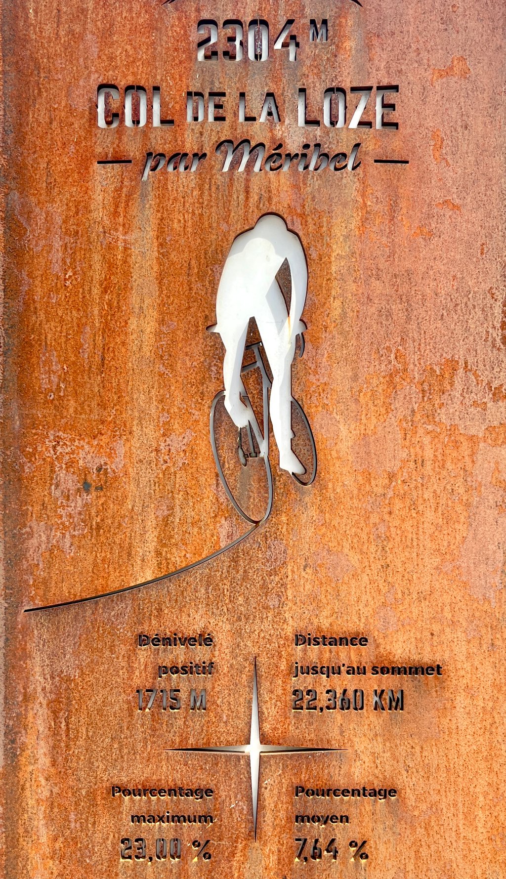
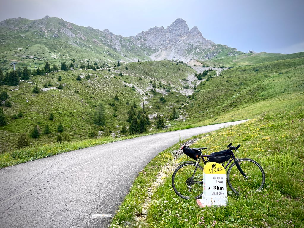
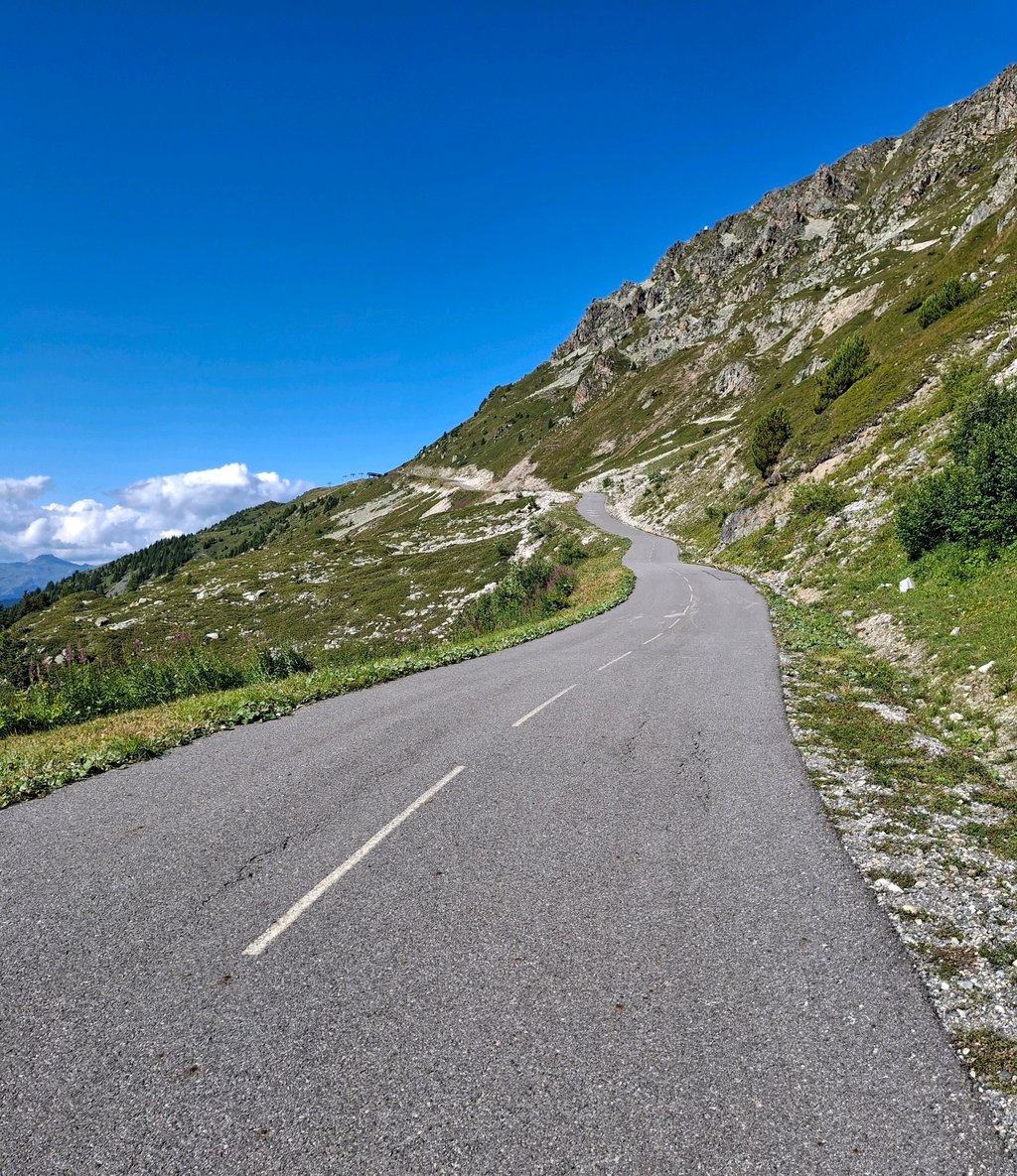
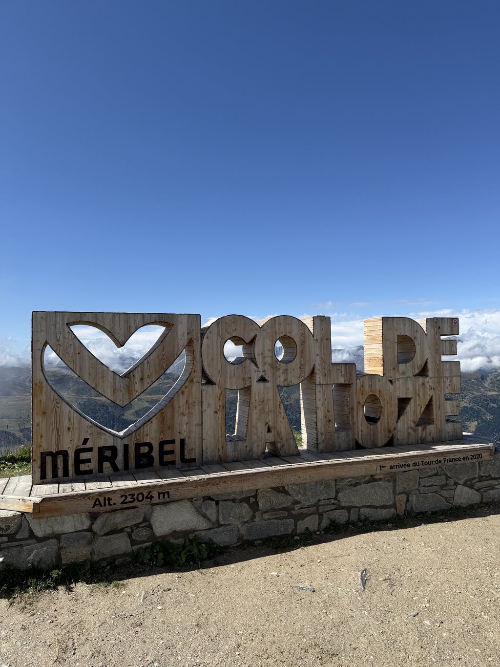
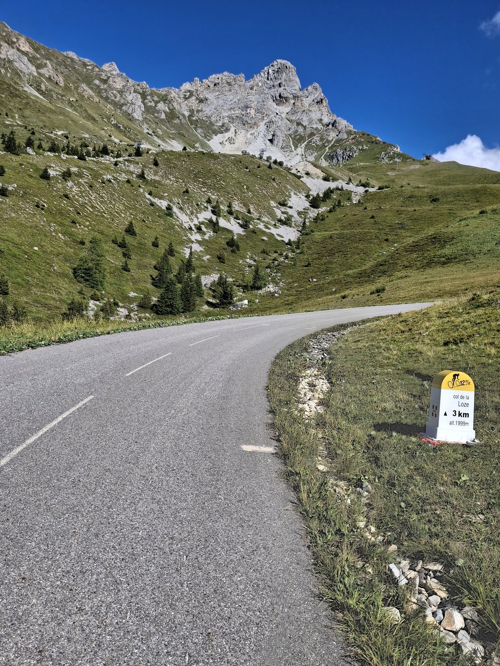
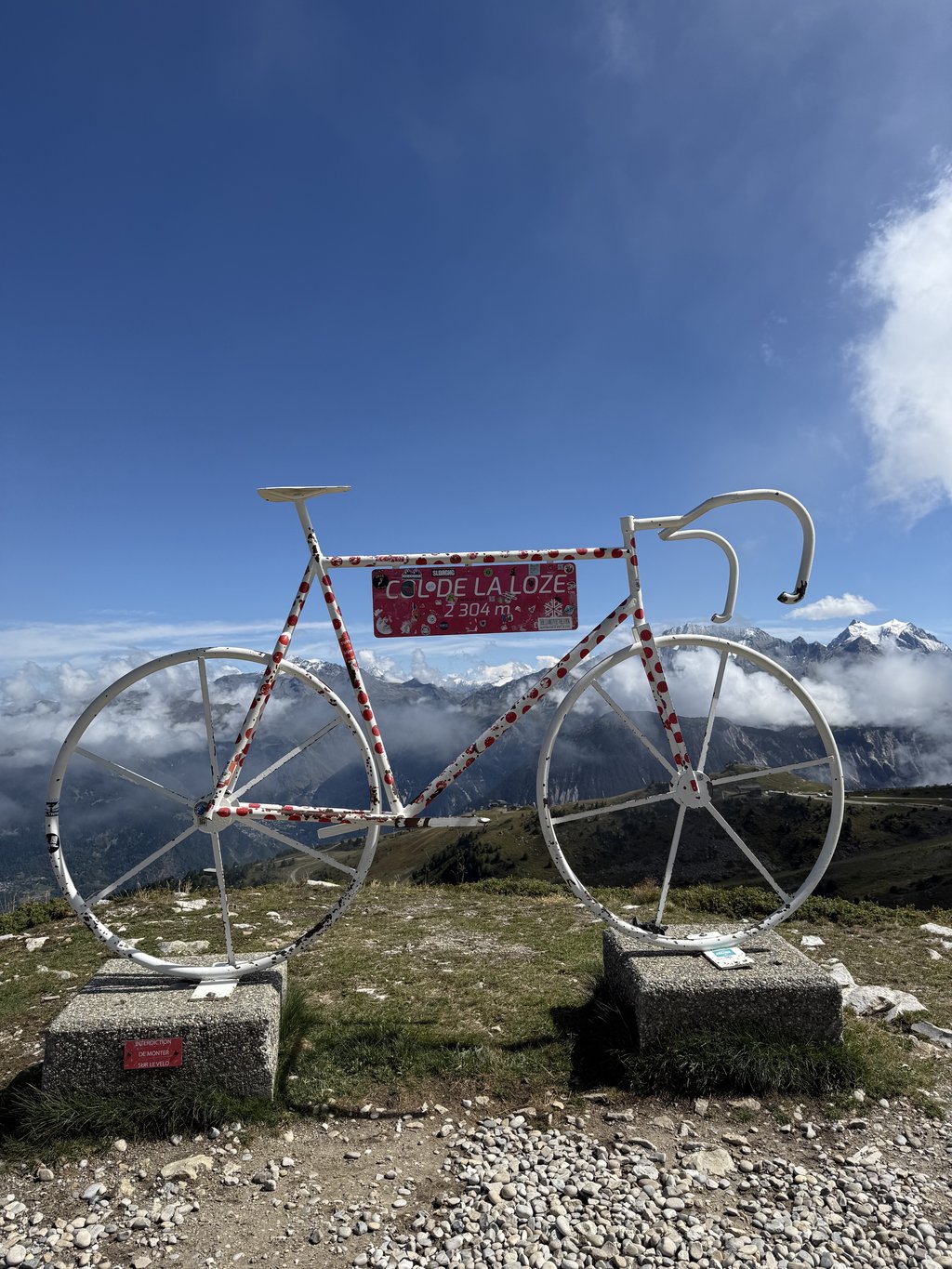
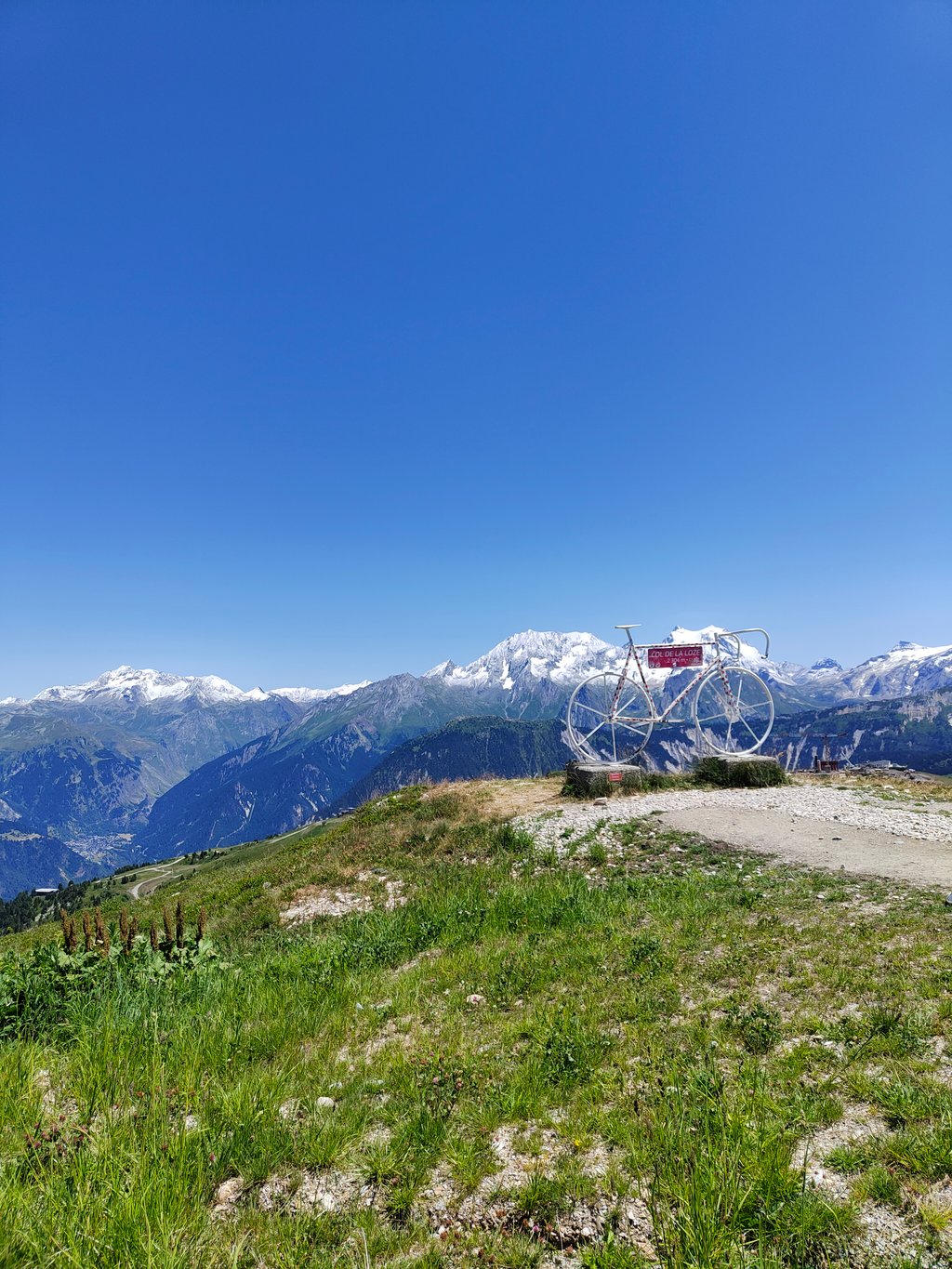
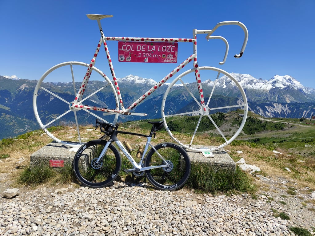
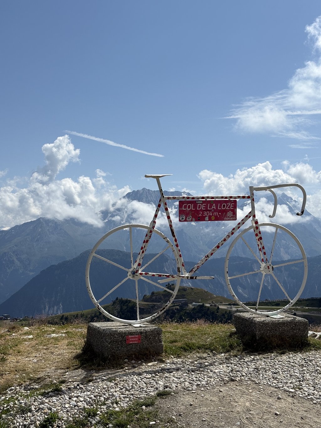
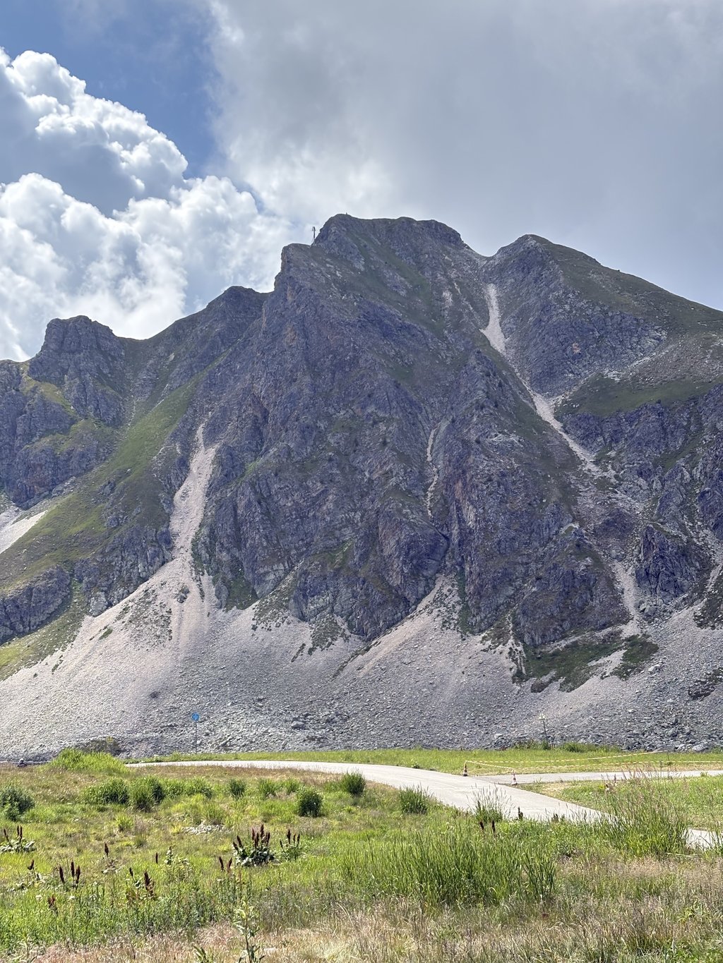
Col de la Loze is a climb in the region Savoie. It is 14 mi long and bridges 5633 ft of vertical ascent with an average gradient of 7.6%, resulting in a difficulty score of 1432. The top of the ascent is located at 7556 ft above sea level. Climbfinder users shared 26 reviews of this climb and uploaded 64 photos.
Road name: D90
5.0 by patrickbaertThis is an automatic translation, the original language is: Dutch.First part is classic col uphill without extreme percentages via hairpin bends up the forested forest flank, then followed by small villages to the larger well-known ski resort Méribel. In summer, there are many construction activities here, which unfortunately caused a lot of heavy traffic along the way. Signposts lead you up through the village in hairpin bends to the start of the bicycle-famous "goat trail". On summer's empty ski slopes, they created a narrow asphalt cycle path. Genius u... read more
Welcome! Please activate your account if you would like to share something. Look for the verification email in your inbox.
If you want to upload your photos, you need to create an account. It only takes 1 minute and it's completely free.
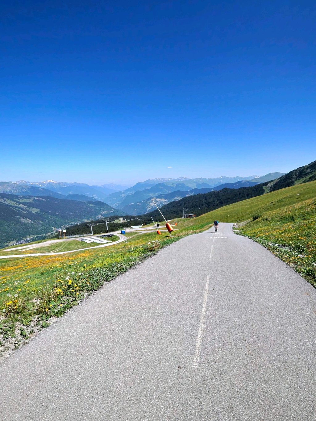
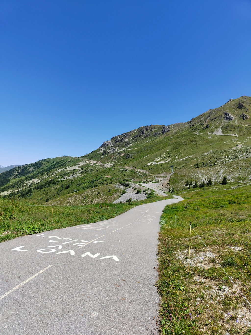
A beautiful, long climb. The first part takes you toward the ski village of Lee Allues, and then toward Méribel. In Méribel, you’ll wind your way uphill through the village for about 2 kilometers. Up to this point, the climb is fairly steady, with an average gradient of about 7%. Above Méribel, the bike path begins, and the climb becomes steeper and more irregular, with several sections between 15% and 20%. Here, you’ll ride through the ski resort with sweeping views of the surrounding area.
Prachtige lange klim. Eerste deel fiets je eerst richting skidorp Lee Allues en daarna richting Meribel. In Meribel slalom je zo'n 2 kilometer door het dorp omhoog. Tot hier in de klim vrij gestaag en zo'n 7% gemiddeld. Boven Meribel start het fietspad en wordt het steiler en onregelmatiger met meerdere stukken tussen de 15- en 20%. Je fietst hier tussen het skigebied en hebt ruim uitzicht om de omgeving.
“It’s the pass of the 21st century,” Christian Prudhomme, director of the Tour de France, likes to say. An old alpine trail—the goat trail—that has become legendary in just five years!
Well, “this 21st-century mountain pass” is described wonderfully well in the previous comments by fellow climbers.
Those who have climbed the Col de La Tougnète will be less surprised by this extraordinary pass.
They’ve already experienced the end of a climb on a bike trail that winds mischievously and treacherously beneath the chairlifts and across the black runs.
But here, the gradients are more unpredictable than on La Tougnète…
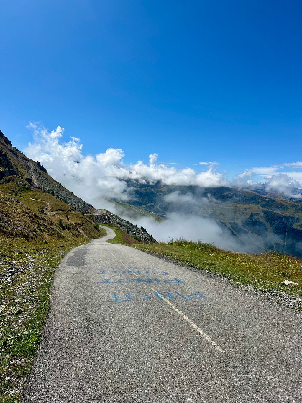
Here, when a sign tells you there’s an 11% grade over the next kilometer, you can be sure of one thing: you won’t be riding at a steady 11%… You’ll get an 18%, then a 4%, then a 16%, then a 7%, then a 20%…
And that’s a strange experience!
What’s really great about this pass is that it’s deserted! That makes you feel less ridiculous as you wriggle around out of the saddle, overcome by a vague sense of helplessness—that feeling of treading water even though you’re completely out of breath.
Your companion on the road and in suffering: you’ll be alone with your bike, which will also be wondering why you’re dragging your feet so much.
Well, I should mention that I climbed in the afternoon amid stormy weather. My only encounter: a fox that had caught a hare.
Not a single marmot in sight.
Warning: this final stretch is demanding and can provoke nervous laughter when you catch sight of the bumps ahead.
Sometimes you might even wonder why you put yourself through this challenge…
“This 21st-century pass” is quite the playground, after all.
Up there, it’s magnificent. Despite the rain—and thanks to it—today was magical.
A few words about the first part of the adventure: a classic climb on a good, fairly busy road (concrete mixer trucks… Yep, construction is in full swing). Two kilometer markers indicate a 10% grade. I believe them. This road isn’t exactly thrilling. Méribel at this time of year is even less so…
Be careful not to miss the entrance to the bike path: turn right at the parking lot by the roundabout near the slopes, just to the right of the ESF. This pass rightfully belongs on the list of must-sees.
« C’est le col du XXIe siècle » aime répéter Christian Prudhomme, le directeur du Tour de France. Un vieux chemin d’alpage, le chemin des chèvres, devenu mythique en 5 ans !
Eh bien, « ce col du XXIe siècle » est formidablement bien décrit par les commentaires précédents des collègues grimpeurs.
Ceux qui ont grimpé le col de La Tougnète seront moins étonnés par ce col hors norme.
Ils ont déjà expérimenté la fin d’une ascension sur une piste cyclable qui serpente avec malice et vice sous les télésièges et sur les pistes noires.
Mais ici, les pourcentages sont plus joueurs que sur La Tougnète…
Ici, quand une borne vous annonce 11% sur le kilomètre suivant, vous pouvez être certain d’une chose : vous ne roulerez pas sur du 11%… Vous aurez droit à du 18%, puis à du 4%, puis à du 16%, puis à du 7%, puis à du 20%…
Et ça, c’est une étrange expérience !
Ce qui est très appréciable sur ce col, c’est qu’il est désert ! Ce qui permet de se sentir moins ridicule quand on se tortille en danseuse, envahi par un vague sentiment d’impuissance, cette sensation de pratiquer un surplace pourtant bien essoufflant.
Compagnon de route et de souffrance : tu seras seul avec ta machine, qui elle aussi, se demandera pourquoi tu te traînes autant.
Bon, il faut dire que j’ai grimpé l’après-midi avec un climat orageux. Ma seule rencontre : un renard qui a chopé un lièvre.
Pas la moindre marmotte.
Attention: ce dernier tronçon est exigeant et peut provoquer des rires nerveux lorsque l’on aperçoit les bosses qui nous attendent.
On peut aussi parfois se demander pourquoi on s’est infligé ce défi…
« Ce col du XXIe siècle » est tout de même un sacré terrain de jeu.
Là-haut, c’est somptueux. Malgré la pluie, mais aussi grâce à elle, aujourd’hui, c’était magique.
Quelques mots sur la première partie de l’aventure : une montée classique sur une bonne route plutôt fréquentée (camions toupies… Eh oui, ça construit à tout va). Deux bornes kilométriques indiquent du 10%. Je les crois. Cette route n’est pas palpitante. Méribel à cette saison l’est encore moins…
Attention à ne pas rater l’entrée de la piste cyclable : on tourne à droite au niveau du parking du rond point des pistes juste à droite de l’ESF.
Ce col appartient de plein droit à la liste des immanquables. Dans la foulée, le col de la Tougnète vous attend.
What a beast, this Col de la Loze. The section between Brides-Les-Baines and Méribel is a pleasant climb; the gradient never gets really tough. But then comes the second section… Near Méribel, the bike path winds through the forest and the climb starts to get erratic. This only gets worse once you leave the forest. Sections with gradients up to 20% make you question your chosen pace, but it never takes long before sections of 10% offer some relief. After pushing your heart rate and power output close to the max, the finish offers some much-needed relaxation with beautiful views and a somewhat touristy photo spot. Unfortunately, I couldn’t take many photos, because stopping isn’t an option on this climb.
Wat een bruut, deze Col de la Loze. Het deel tussen Brides-Les-Baines en Meribel klimt aangenaam, het stijgingspercentage wordt nooit echt vervelend. Maar dan het tweede deel.. bij Meribel gaat het fietspad slingerend door het bos en begint de klim onregelmatig te worden. Dit neemt alleen maar toe zodra je het bos verlaat. Stukken tot aan 20% doen je twijfelen aan je gekozen tempo, maar lang duurt het nooit voor stukken van 10% enige verlichting bieden. Na de hartslag en het vermogen richting de max te hebben gebracht biedt de aankomst enige enige ontspanning met mooi uitzicht en een wat toeristisch aandoend fotopunt. Helaas weinig foto’s kunnen maken, want stoppen is er op deze klim niet bij.
An amazing climb in every way. The first 15 km are manageable, but after that it’s a real ordeal. I rode it on what was probably the hottest day of the year, and there was very little shade during the final kilometers. Those last kilometers are intense, steep, and uneven—everything that makes this climb so great.
Geweldige klim in alles. De 1e 15 km goed te doen, daarna een regelrechte beproeving. Gefietst op ongeveer de warmste dag van het jaar en weinig schaduw in de laatste kilometers. Die zijn heftig, steil, onregelmatig, alles wat deze klim geweldig maakt.
The first part is a main road, and in summer there's a lot of construction in Méribel. The last 7 km are on a cycle path. First in the forest, then the last 4 kilometers in the open (presence of ski facilities) where we alternate between short passages around 20% and flats, which makes the climb so special. I give 5 stars to the last 2 kilometers, almost in a straight line, where you get a glimpse of the summit and the slope variations to come, in a particularly calm environment, a great moment. Watch out on the way down for the occasional hairpin bend in the steep gradients.
La première partie est une grande route, et en été il y a beaucoup de construction à Méribel. Ce sont les 7 derniers kilomètres qui sont sur une voie cyclable. D'abord en forêt, puis les 4 derniers kilomètres à découvert (présence d'installations de ski) où on alterne entre de courts passages autours de 20% et des replats, ce qui rend la montée si particulière. Je donne 5 étoiles pour les 2 derniers kilomètres en presque ligne droite où vous appercevez le sommet et les variations de pente à venir, dans un environnement particulierement calme, un super moment. Attention en rededcendant aux quelques épingles dans les forts pourcentages.
Loved this climb, if this is not a 5 star, I don't know what is. Col de A proper test: long, relentless, and unlike anything else in the Alps. The lower slopes feel manageable, but the final kilometres are out of this world. It’s quiet compared to the big-name climbs, which adds to the experience. The surface is smooth but narrow, and pacing is everything. Tough, a bit brutal, but definitely one that sticks in your memory. This article is full of tips
https://epicroadrides.com/cycling-blog/col-de-la-loze-guide/
What a challenge! Up to the foot of the slopes, the climb goes relatively well with stable % varying between 6 and 9%. After that, it gets a lot tougher! Be aware, however, that after each "wall" you have a flat area or a descent, so you can catch your breath. Between km 4 and 2 of the summit, it's really the hardest: you're told a km @ 12% and imagine there's a descent in that km, so the rest is really steep. The views at the top are magnificent.
Quel beau défi! Jusqu’au pied des pistes, la montée se fait relativement bien avec des % stable variant entre 6 et 9%. Par la suite, c’est beaucoup plus corsé! Sachez par contre qu’après chaque « mur » vous avez un replat ou une descente, donc on peut reprendre son souffle. Entre les km 4 et 2 du sommet, c’est vraiment le plus difficile: on vous annonce un km @ 12% et imaginez-vous qu’il y a une descente dans ce km, donc le reste est vraiment raide. Les vues au sommet sont magnifiques.
Climbing the Gran Fondo. The physical challenge is as challenging as it is legendary; the pass lives up to its reputation!
The first half is fairly classic for an Alpine pass, with wide switchbacks, a steady gradient and generally decent tarmac. The crossing of Méribel is much bumpier, but once above the village, on the piste, you can't complain about the quality of the road. Just the gradient! A succession of walls at over 20% where the arms work twice as hard as the legs, and rare but welcome flats. A legendary pass!
Montée à l'occasion du Gran Fondo. Le défi physique est tout aussi challengeant qu'il est légendaire ; le col tient sa réputation !
Plutôt classique pour un col des Alpes dans sa première moitié : lacets larges, pente régulière et asphalte globalement correcte. La traversée de Méribel est beaucoup plus cahoteuse, mais une fois au-dessus du village, sur la piste, on ne peut plus se plaindre de la qualité de la route. Seulement de la pente ! S'enchaînent murs à plus de 20% où les bras travaillent deux fois plus que les jambes, et replats rares mais bienvenus. Col de légende !
Ascent divided into 2 parts. Up to Méribel, a wide and very regular road. Then you take a cycle track and the gradient becomes very uneven. Inclines of even more than 20% alternating with stretches where you can catch your breath
Salita divisa in 2 parti. Fino a Méribel strada ampia e molto regolare. Poi si prende una ciclabile e la pendenza diventa molto irregolare. Pendenze anche superiori al 20% alternati a tratti in cui tirare il fiato
From Brides les Bains, the climb up to Méribel is over a large and fairly busy track. Long stretches with regular percentages. From the moment you turn onto the cycle path at the top of Méribel, the climb becomes hugely irregular. In a few hundred metres you switch between sections between 4 and 15 per cent. This will continue until the summit. Until this stretch, it is best not to ride too fast, so the last kilometres are a lot more similar. The descent along this or the other side can be dangerous in some sections with the very steep turns.
Vanuit Brides les Bains is de klim tot in Méribel over een grote en vrij drukke baan. Lange stukken met regelmatige percentages. Vanaf je boven in Méribel het fietspad opdraait wordt de klim enorm onregelmatig. Op een paar honderd meter wissel je tussen stukken tussen 4 en 15 procent. Dit zal tot de top blijven duren. Tot voor dit stuk rij je best niet te hard, zo zijn de laatste kilometers een pak dergelijker. De afdaling langs deze of de andere kant kan op sommige stukken met de heel steile bochten gevaarlijk zijn.
First part is classic col uphill without extreme percentages via hairpin bends up the forested forest flank, then followed by small villages to the larger well-known ski resort Méribel.
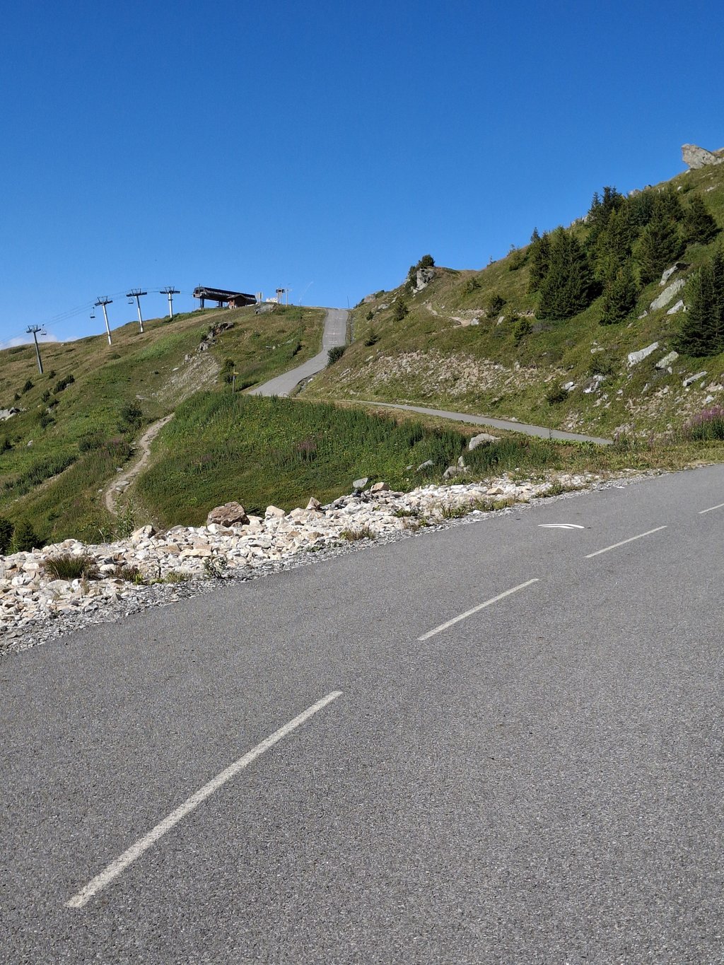
In summer, there are many construction activities here, which unfortunately caused a lot of heavy traffic along the way. Signposts lead you up through the village in hairpin bends to the start of the bicycle-famous "goat trail".
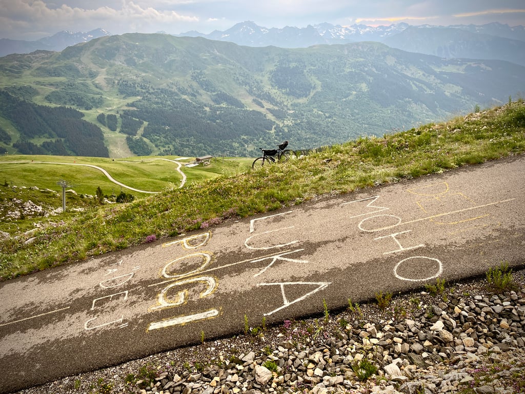
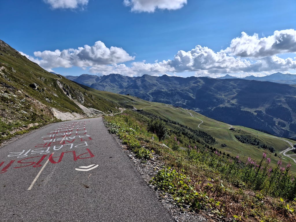
On summer's empty ski slopes, they created a narrow asphalt cycle path. Genius unique idea with pros and cons. Contrast with first part could not be greater. No traffic, silence except your own breathing and pure nature if you think away the ski infrastructure. You can't get into your climbing rhythm because these last 8 km are a textbook example of irregularity. Within 100 metres it can vary from short downhill, flat, climbing to murderously steep. Besides the "Wout Jonas Pogi ...."painted tarmac, there were also playful encouragement signs for the mere mortal like me.
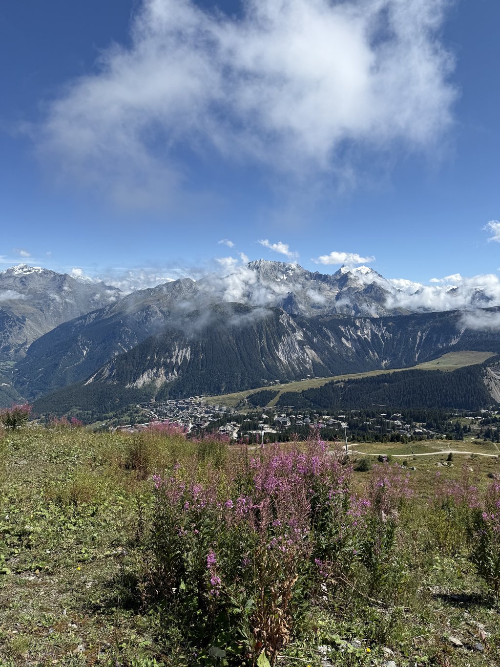
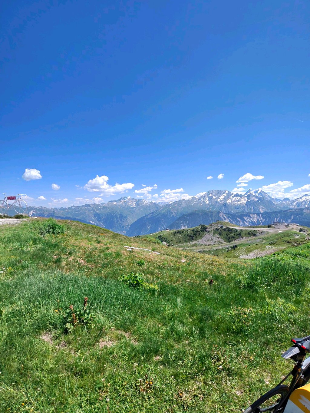
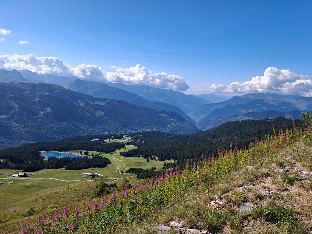
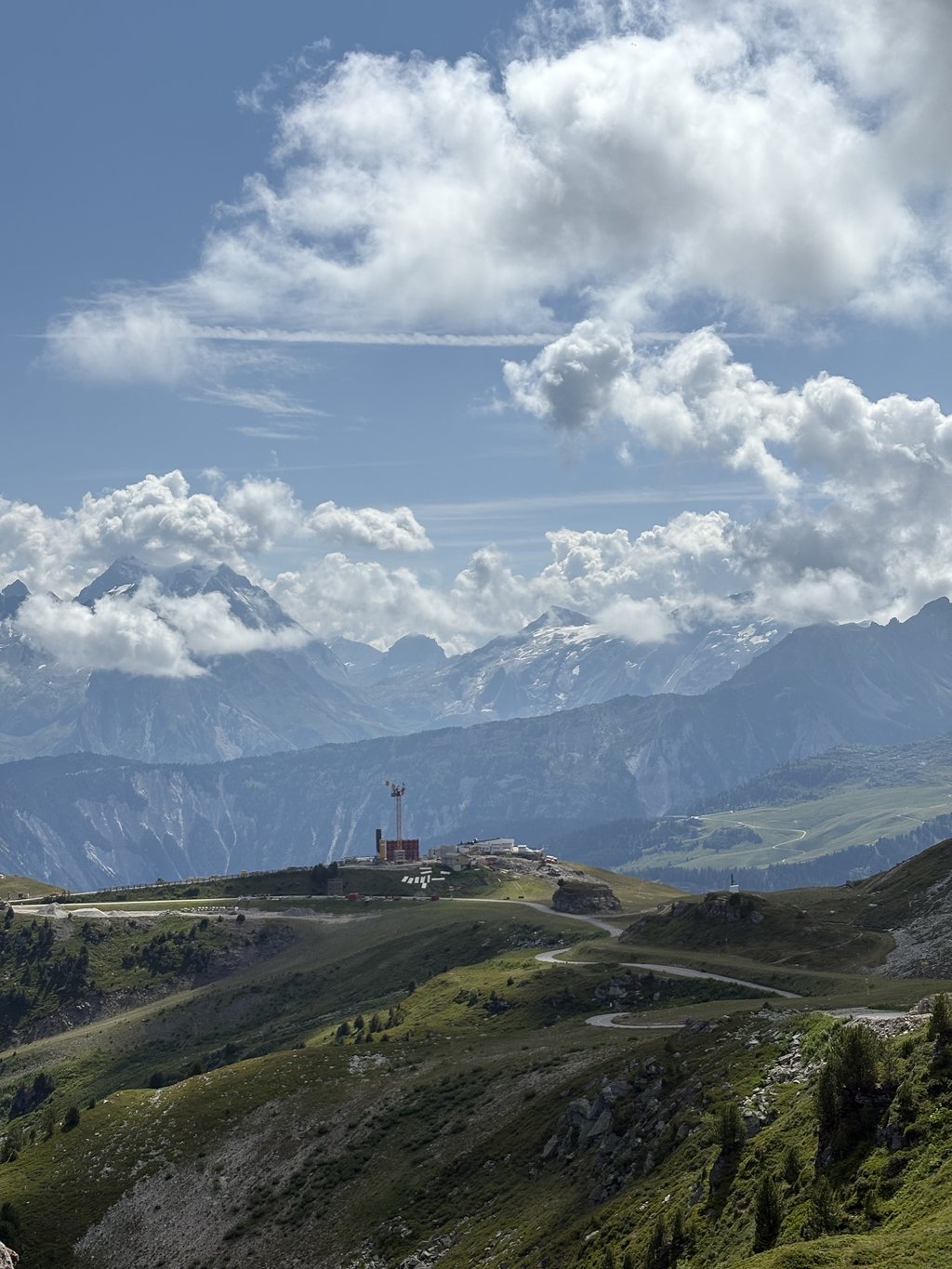
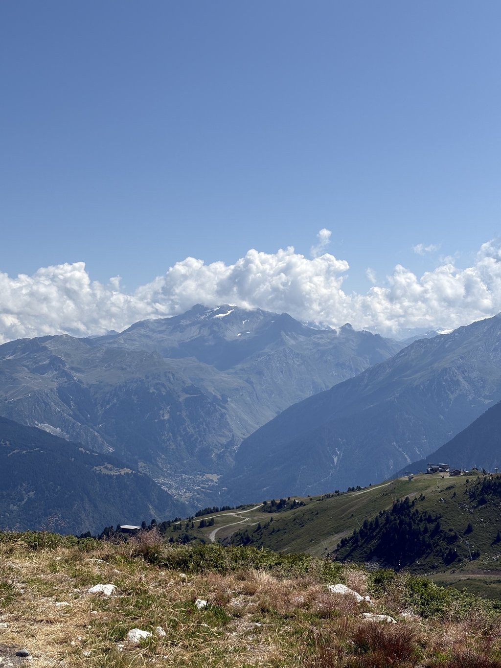
Summit is 360° panorama with Mont Blanc as eye-catcher and well worth all the effort. Fortunately, the cloud cover broke open when I arrived among my frame. I took in the pumping music of an organised cyclo along the Courchevel side.
Practicalities:
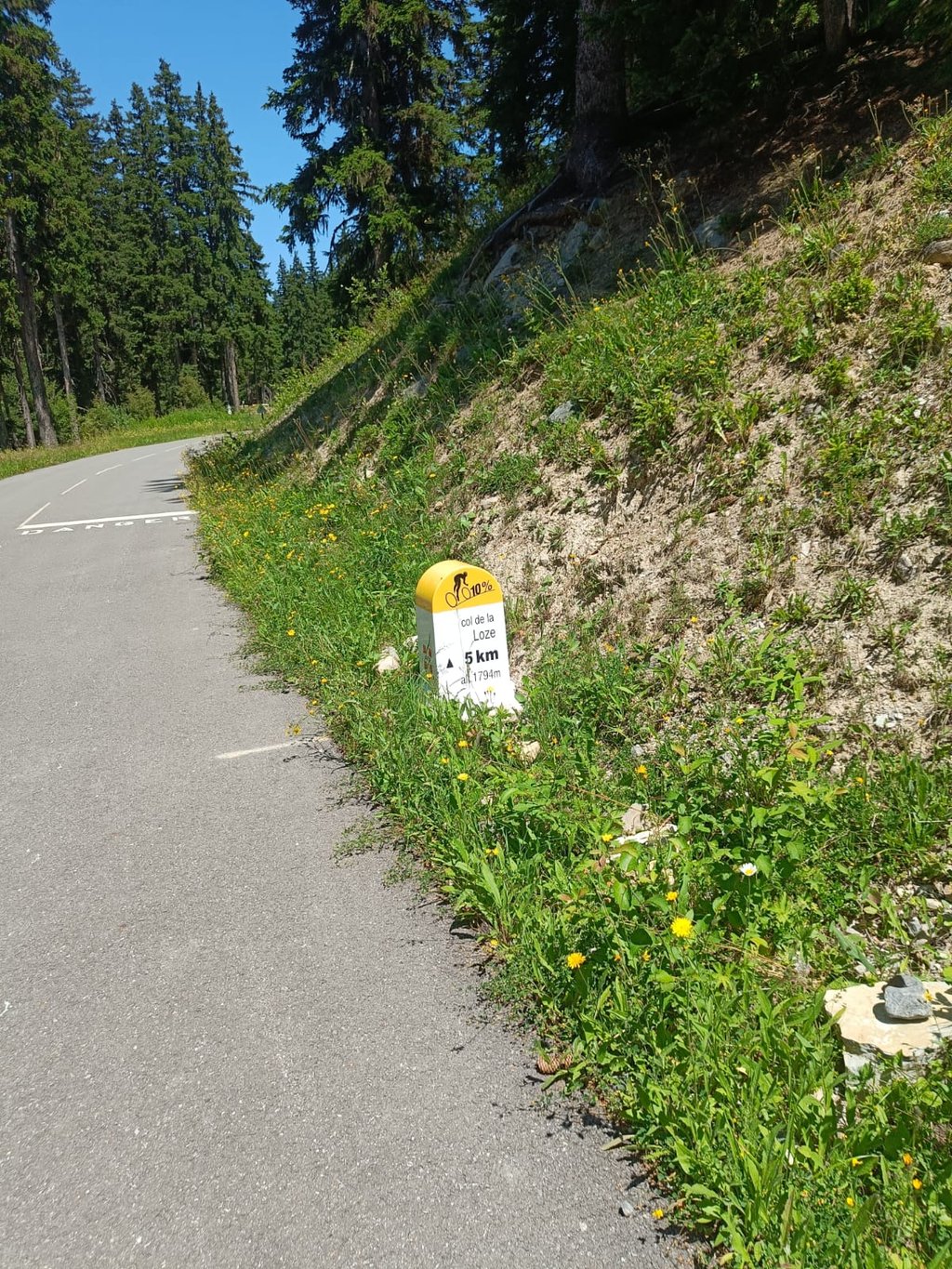
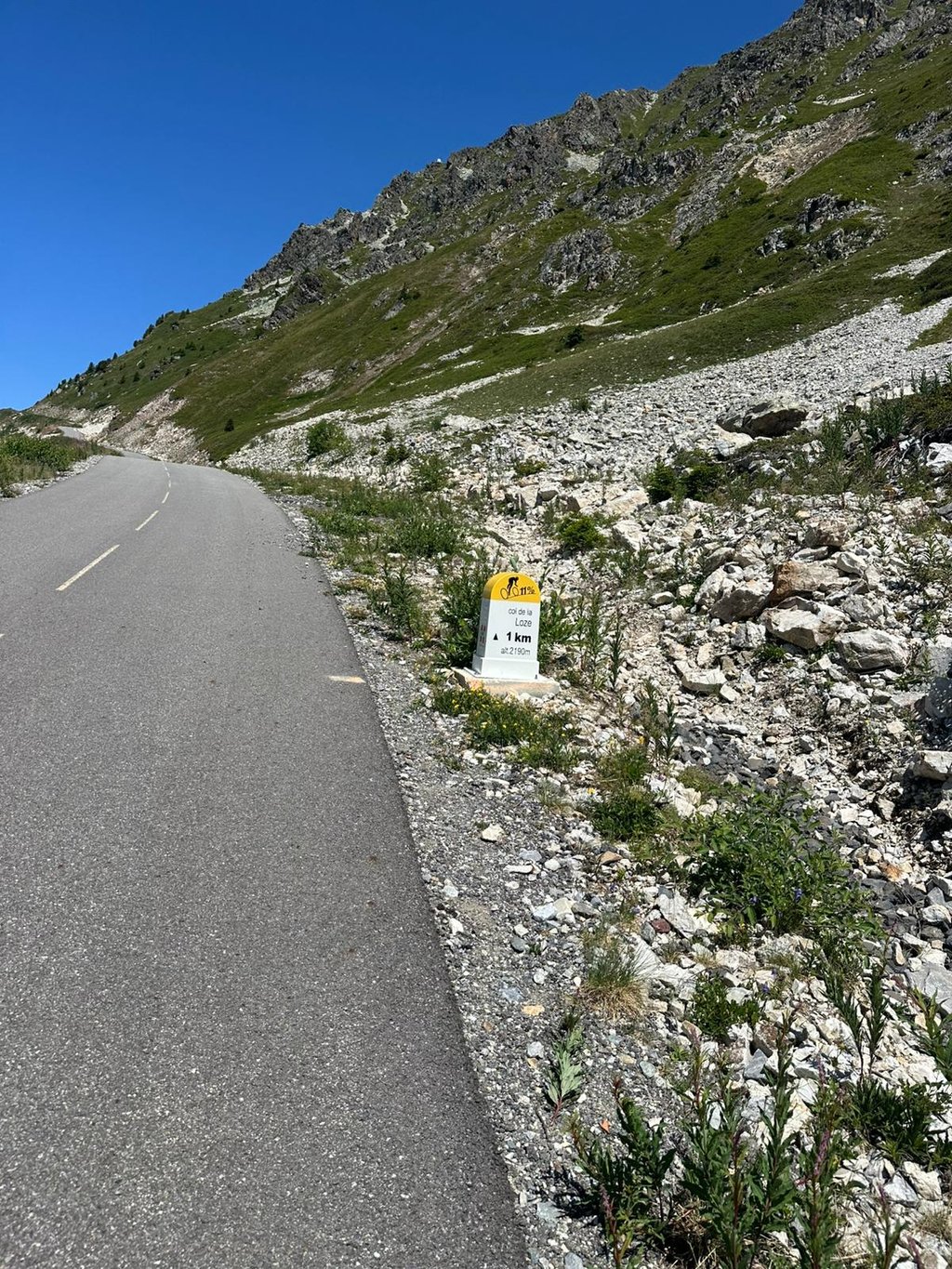
-From the start in the valley, there are already the familiar white-yellow kilometre markers with distance to the summit, altitude and % next km. The latter on the cycle path to be taken with a grain of salt, of course .
-Less heavy traffic on weekends due to less construction activity.
Decision: Artificial yet UNIQUE, not to be missed!!!!!!
Eerste deel is klassieke col bergop zonder extreme percentages via haarspeldbochten de beboste woudflank op, nadien gevolgd door kleine dorpjes tot het grotere gekende skioord Méribel.
Hier zijn er zomers op vele plaatsen (ver)bouwactiviteiten, wat spijtig genoeg onderweg voor veel zwaar verkeer zorgde. Wegwijzers loodsen je haarspeldbocht gewijs al pittig dwars omhoog door het dorp, tot het begin van het fiets beroemde "geitenpad".
Op zomers lege skipistes creëerde men een smal geasfalteerd fietspad. Geniaal uniek idee met voor en tegenstanders. Contrast met eerste deel kan niet groter zijn. Geen verkeer, stilte tenzij je eigen ademhaling en puur natuur als je de ski infrastructuur wegdenkt. Je kan niet in je klimritme komen want deze laatste 8 km zijn een schoolvoorbeeld van onregelmatigheid. Binnen de 100 meter kan het variëren van kort bergaf, vlak, klimmend tot moordend steil. Naast het met "Wout Jonas Pogi ...."beschilderde asfalt waren er ook nog ludieke aanmoedigingsbordjes voor de gewone sterveling zoals ik.
Top is 360° panorama met Mont Blanc als blikvanger en alle inspanningen meer dan waard. Gelukkig brak het wolkendek open toen ik tussen mijn kader arriveerde. De pompende muziek van een georganiseerde cyclo langs de Courchevel kant nam ik er bij.
Praktisch:
-Vanaf de start in het dal zijn er al de gekende witgele kilometerpalen met afstand tot de top, hoogte en % volgende km. Dit laatste op het fietspad uiteraard met een korrel zout te nemen .
-Minder zwaar verkeer in het weekend wegens minder bouwactiviteit.
Besluit: Kunstmatig doch UNIEK, niet te missen!!!!!!
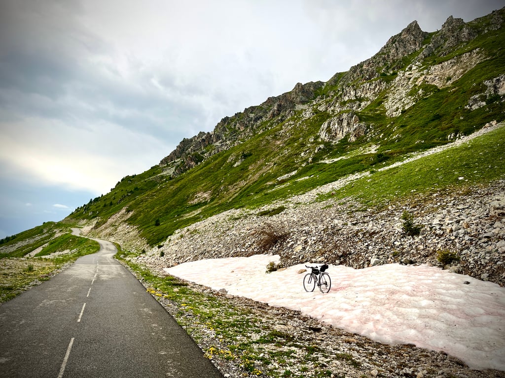
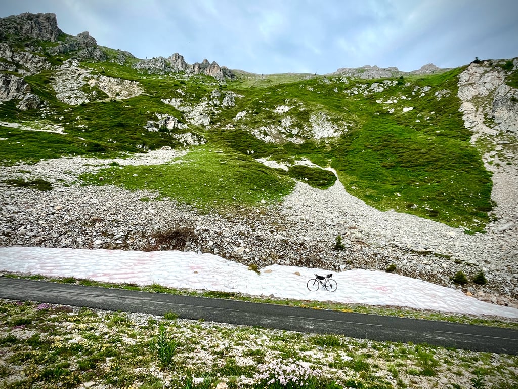
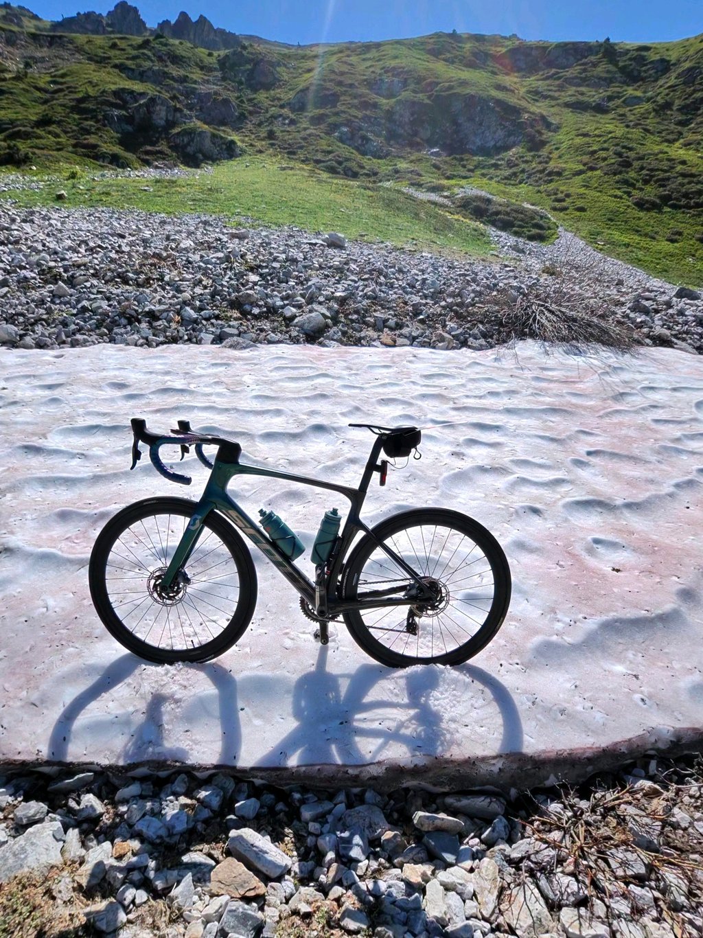
The stunning views at the top alone make this climb well worth it! And as everyone has already said, up to Meribel it's fine. In Meribel, it is good to find where to go. Just before the 'asphalted goat path' starts you even have to ignore a sign saying to keep left for a very short time. After that, the climb becomes super irregular. Those bits of 20% didn't need to be from me, but the reward at the top is worth it! Magnificent views of Mont Blanc, among others! Ridden in early June so there was still quite a bit of snow.
Alleen al het prachtige uitzicht op de top maakt deze klim zeker de moeite waard! En zoals iedereen al heeft gezegd, tot aan Meribel gaat het prima. In Meribel is het goed zoeken waar je naartoe moet. Vlak voor het 'geasfalteerde geitenpad' begint moet je zelfs heel eventjes een bord negeren dat zegt dat je links aan moet houden. Daarna wordt de klim super onregelmatig. Die stukjes 20% hadden van mij niet gehoeven, maar de beloning bovenop is de moeite waard! Schitterend uitzicht op o.a. de Mont Blanc! Begin juni gereden waardoor er nog best wat sneeuw lag.
A monster... Starts like a typical alpine col at averages of 7%, on a relatively large track (traffic still fell), but it is the last 6.5 km's that set this col apart from the rest. In this section, you cycle uphill on a unique bike path between the ski lifts, alternating between walls (15-20%) and flatter sections. Because of this last 6.5 km, this is highly recommended, both a physical challenge and enjoying the views!
Een monster... Begint net als een doorsnee alpen col aan gemiddeldes van 7%, op een relatief grote baan (verkeer viel nog wel), maar het zijn de laatste 6,5 km's die deze col onderscheiden van de rest. In dit gedeelte fiets je op een uniek fietspad tussen de ski liften naar boven, waarbij muren (15-20%) en vlakkere delen elkaar afwisselen. Omwille van deze laatste 6,5 km is dit wel een echte aanrader, zowel een fysieke uitdaging als genieten van het uitzicht!
The col actually only starts at the top in Meribel, up to Maribel it is doable regular slope that sometimes touches 10% very briefly in the beginning but is not too steep after that . From Meribel it's another 10 Km averaging 8.4%, I've done worse but it doesn't compare to this interval slope. In Meribel you first have to go 3 Km to the Ski Lift where you find the start of the nicely paved goat path. By taking it easy on the less steep sections and catching my breath, I was able to keep cycling in one go. I think the steepest stretch is between 10 and 11% on the map The last stretch is tougher than the map suggests. A long stretch where you are somewhere around 13%. the last bit is slightly less steep but the legs say otherwise. And yes you just cycle through the ski area along and over the slopes. At the top you have great views and views of Mt Blanc.
De col begint eigenlijk pas boven in Meribel, tot Maribel is het goed te doen regelmatige helling die in het begin soms heel even 10% aanraakt maar daarna niet al te steil is . Vanaf Meribel is het nog 10 Km gemiddeld 8,4%, dat heb ik al erger gedaan maar is niet te vergelijken met deze interval helling. In Meribel moet je eerst nog 3 Km naar de Skilift waar je de start van het mooi geasfalteerde geiten pad vind. Door de minder stijle stukken rustig aan te doen en op adem te komen, kon ik in één keer door blijven fietsen. Het stijlste stuk zit volgens mij tussen het 10 en 11% op het kaartje Het laatste stuk is zwaarder dan het kaartje doet vermoeden. Een lange strook waar je ergens rond de 13% zit. het laatste stukje is iets minder stijl maar de benen zeggen anders. En ja je fiets gewoon door het skigebied langs en over de pistes heen. Boven heb je een prachtig uitzicht en zicht op de Mt Blanc.
Super fun and weird climb, starting from Meribel with very steep sections interspersed with flat. The climb starts nice and continuous and you get into a good rhythm. From Meribel onwards it's a bit less, with a few km through a ski village on less tight tarmac. During the first 15km, I tried to dose to have enough left for the steep part, but there you have to go deep anyway.
Superleuke en rare beklimming, met vanuit Meribel hele steile stukken afgewisseld met vlak. De klim begint lekker continu en je komt goed in een ritme. Vanaf Meribel is het even wat minder, met een aantal km door een skidorp over minder strak asfalt. Tijdens de eerste 15km probeerde ik te doseren om over te houden voor het steile stuk, maar daar moet je hoe dan ook diep gaan.
Up to Meribel, that's 14km of climbing at regular percentages around 8 pct.
But those last 7km!!!
Pieces of 14 15 16 pct.
But very irregular. 4km from the top 11pct average. 3km from the top 12pct.
Then you think you've had it all and then comes the final kilometre with a wall like the Planche de belle files. 24pct!
But it was all worth it. Most beautiful views, Mont Blanc in the clouds....
Beautiful! Yet painful!
Tot aan Meribel is dat 14km klimmen aan regelmatige percentages rond de 8 pct.
Maar die laatste 7km!!!
Stukken van 14 15 16 pct.
Maar heel onregelmatig. 4km van de top 11pct gemiddeld. 3km van de top 12pct.
Dan denkt ge dat ge alles gehad hebt en dan komt de slotkilometer met een muur zoals de Planche de belle files. 24pct!
Maar het was het allemaal waard. Mooiste vergezichten, Mont Blanc in de wolken...
Prachtig! Doch pijnlijk!
Amazing experience to ride this climb, also because on the tour that day, with lots of public at the side of the road to cheer on all amateurs who did the climb. But also on regular days, changing gradients make this a beast of a climb, highly recommended (from this side) and descent via Courcheval.
Reading the experiences here you think the beginning is easy but the first few kilometres are pretty tough. At some point it gets better. Just make sure you cycle in the right direction or I went wrong a few times. Once you're on the cycle path, good luck it's going to be gruelling. The views are spectacular!
Als je de ervaringen hier leest denk je het begin is makkelijk maar de eerste kilometers zijn best zwaar. Op een gegeven moment gaat het wel wat beter. Let wel goed op dat je de juiste richting op fietst zel ben ik een paar keer verkeerd gegaan. Als je eenmaal op het fietspad zit veel succes het gaat gruwelijk worden . De uitzichten zijn spectaculair!
I will repeat what has already been said. Up to Méribel, a walk in the park. After that, it's another matter. Difficult because of the constant change of slope. Difficult to know where our energy reserves are. The end at 24% is TERRIBLE, as is the last ass-kicking...
Je vais redire ce qui a déjà été dit. Jusqu à Méribel, promenade de santé. Après, c’est une autre affaire. Difficile parce que d’incessants changement de pente. Difficile de savoir ou en est de nos réserves d’énergies. Le bout à 24% est TERRIBLE tout comme le dernier coup de cul…
This is one of those climbs that starts out fine, but ends up terribly steep. Man, that last part, which was specially built for cyclists, is impossible to do. And all those people on electric mountain bikes whizzing by make it mentally awful. But as is often the case with pain on the bike, you soon forget that when you reach the top. Delightful!
Dit is zo een klim die prima fijn begint, maar verschrikkelijk stijl eindigt. Man, dat laatste stuk, dat speciaal is aangelegd voor fietsers, is niet te doen. En al die lui op elektrische mountainbikes die voorbij zoeven maken het mentaal verschrikkelijk. Maar zoals het wel vaker gaat met pijn op de fiets, ben je dat zo vergeten als je boven op de top eindigt. Heerlijk!
The last 6km of the route is hard work, with memories of the Mortirolo. I agree with the review that it all looks very artificial. Anyway: rightfully number 2 of France based on gravity! I think the Galibier is much prettier...
Laatste 6km flink aanpoten, met herinneringen aan de Mortirolo. Ik ben het eens met de review dat het allemaal erg kunstmatig aandoet. Anyway: terechte nummer 2 van Frankrijk obv zwaarte! Galibier vind ik wel stukken mooier..
Pretty easy approach from Moutiers. From Brides les Bains it becomes more serious, a real col. But from Meribel it becomes really special. The statistics per kilometre don't show it, but the last 8 km consist of bizarre climbing percentages. From 4% to 13% to 8% to 15% etc. With short stretches around 20%, but also a bit of descent. As if you were cycling uphill on an asphalted mountain bike path. It is also specially built for cyclists and car-free. This gives it something artificial, unfortunately. More difficult than and incomparable with any French Alpine col, as far as I am concerned. At the top beautiful views await, including on the Mont Blanc massif. The descent is easy until Courchevel. After that you have to be careful because of the road surface and traffic. If you cycle up this way you miss the bizarre percentages, but also the essence of this col.
Vrij eenvoudige aanloop vanuit Moutiers. Vanaf Brides les Bains wordt het serieuzer, een echte col. Maar vanaf Meribel begint wordt het pas bijzonder. De statistiek per kilometer geeft het niet aan, maar de laatste 8km bestaan uit bizar wisselende klimpercentages. Van 4% naar 13% naar 8% naar 15% etc. Met korte stukjes rond de 20%, maar ook een stukje afdaling. Alsof je over een geasfalteerd mountainbikepad bergop fietst. Het is ook speciaal voor fietsers aangelegd en autovrij. Dat geeft het ook iets kunstmatigs, helaas. Lastiger dan en onvergelijkbaar met welke Franse Alpencol dan ook, wat mij betreft. Boven wachten mooie uitzichten, oa op het Mont Blanc massief. De afdaling is tot Courchevel goed te doen. Daarna is het oppassen vanwege het wegdek en verkeer. Als je langs deze kant omhoog fietst mis je de bizarre percentages, maar ook de essentie van deze col.
Insanely beautiful climb. Climbed in 2021 from Brides les Bains. First part is on the highway and through winter sports villages, but in terms of traffic it is not so bad. Last 7 is a lot of hard work, first a nice cooling forest with steep, short, sections and then later more vast plains (ski slopes). Col is well signposted, nice new asphalt. The devil is in the tail, the gradients alternate up to 19% but this is always short and then there is room for some recovery. Last part, finish uphill and you will be rewarded with a beautiful view. The descent is clear and not difficult, just be careful at higher speeds, because the asphalt in Courchevel is not exactly a biljartlaken (as it is uphill). The Galibier is especially longer, the Col de la Loze is more difficult. Quite a few kilos too much or a moderate mountain set-up will get you into trouble here.
Waanzinnig mooie klim. Beklommen in 2021 vanuit Brides les Bains. Eerste stuk gaat over de autoweg en door wintersport dorpjes, maar qua drukte valt dat heel erg mee. Laatste 7 is flink aanpoten, eerst een fijn verkoelend bos met flinke steile, korte, stroken en dan later wat meer uitgestrekte vlaktes (skipistes). Col staat goed aangegeven, mooi nieuw asfalt. Het venijn zit in de staart, de stijgingspercentages wisselen elkaar af tot 19% maar dit is altijd kort en daarna is er weer ruimte voor wat herstel. Laatste stukje, finish berg-op en je wordt beloond met een prachtig uitzicht. Afdaling is overzichtelijk en niet moeilijk, alleen opletten bij hogere snelheden, want asfalt ri Courchevel is niet bepaald een biljartlaken (zoals het omhoog wel is). De Galibier is vooral langer, de Col de la Loze is moeilijker. Flink wat kilo's teveel of een matig bergverzet, brengt je hier wél in de problemen.
Beautiful climb, which is really unique from Meribel, where (part of) the ski slope was paved. This makes for a roller coaster feeling with ever changing percentages, up to 24%! Unfortunately, the last kilometer was still snowed in, so I couldn't reach the top...
Prachtige beklimming, die pas echt uniek wordt vanaf Meribel, waar (een deel van) de skipiste geasfalteerd werd. Dit zorgt voor een achtbaangevoel met steeds wisselende percentages, tot 24%! Helaas lag de slotkilometer nog ondergesneeuwd, waardoor ik de top niet kon halen...
Last year in September. Until Méribel an alpencol as there are so many, but after the village when the 'bike path' begins it is very special. The climb is much harder than the profile suggests, with ever changing percentages. Café at the top with beautiful panorama.
Must also have done!
Vorig jaar in september beklommen. Tot in Méribel een alpencol zoals er zovelen zijn, maar na het dorp wanneer het 'fietspad' begint is het héél speciaal. De klim is veel zwaarder dan het profiel doet vermoeden, met steeds wisselende percentages. Café op de top met schitterend panorama.
Moet je ook gedaan hebben!
| 5 mph | 02:49:07 |
| 7 mph | 01:59:43 |
| 9 mph | 01:33:18 |
| 12 mph | 01:10:06 |
This page is better in the app