View on map
© MapLibre | OpenStreetMap contributors
1%
2%
4%
6%
8%
10%
12%
15%
20%

Barrage de Moiry from Chippis via Briey

5.0
6 reviews | Elevation profile | 16 photos
Barrage de Moiry from Chippis via Briey
Your achievable time
Calculating based on your best performances...
Relaxed
Maximum
W/kg
W/kg
W/kg
Analyze your climbing performance
Detailed insight into your climbing performance & automatically check off climbs
Based on your best performances.
Your best attempt:
Number of attempts:
Elevation profile Barrage de Moiry from Chippis via Briey

Statistics

Difficulty points 1758
Length 20.2 mi
Average gradient 6.3%
Steepest segment 17.3%
Total ascent 6703 ft

Short recap

17 hairpin turns
#80 toughest climb of World
#75 most elevation gain of World
#42 longest climb of Alps
Feedback about this climb?
Show climbs nearby Export to GPS device

Barrage de Moiry from Chippis via Briey is a climb in the region Valais. It is 20.2 mi long and bridges 6703 ft of vertical ascent with an average gradient of 6.3%, resulting in a difficulty score of 1758. The top of the ascent is located at 7480 ft above sea level. Climbfinder users shared 6 reviews of this climb and uploaded 16 photos.

Road names: Route de Briey, Route de Briey de Chippis, Route de Vercorin, Route de Moiry &

5.0 by ZachW
This is an automatic translation, the original language is: English.
Awe inspiring climb. The dam appears around a corner with three kms to go and looks entirely unassailable. The first climb is mostly switchbacks on a small road through quiet vineyards. While the road surface isn't perfect, it gets the job done. After Briey you join a larger road which is much smoother but a bit more trafficked. A tiny descent after Vercorin leads to couple kilometers of very scenic climbing before a surprisingly difficult descent Mayoux. This descent terminates very abrupt... read more

Photos (16)

Barrage de Moiry from Chippis via Briey
transparant thumb
transparant thumb

Your uploads (max 4)

Welcome! Please activate your account if you would like to share something. Look for the verification email in your inbox.

If you want to upload your photos, you need to create an account. It only takes 1 minute and it's completely free.

  • Receive free climbfinder goodies for your reviews & photos.
  • Create a bucket list and check off conquered climbs.
  • Add missing climbs.
Continue with GoogleContinue with Google Continue with FacebookContinue with Facebook Continue with AppleContinue with Apple Sign up with email
By signing up you agree to our terms of service and confirm that you have read our privacy & content policy.

Reviews (6)

5.0
4.0
3.0
2.0
1.0
PetraVDB
9 Mo 5.0 via the Climbfinder app

Zalige klim! Prachtig uitzicht boven. Weinig auto's. 2 tussenafdalingen komen goed uit. Zeker flessen bijvullen in grimentz want daarna is er geen optie meer. Restaurant boven ook de moeite maar wel koud in de schaduw. Ook de moeite om nog even verder te rijden voor het mooie uitzicht

Barrage de Moiry from Chippis via Briey
Dashboard
Yoachje
9 Mo 5.0 via the Climbfinder app
This is an automatic translation, the original language is: Dutch. Show original

Just the Max. All the effort that goes into this climb with its steep and long gradients. You can see the glacier and it is really beautiful. The climb does climb hard as there are few turns for the big difference in altitude. I think it is really super.

Gewoon de Max. Alle inspanningen die deze klim met zijn steil en lange hellingen met zich meebrengt. Je ziet de gletjer en het is echt mooi. De klim klimt wel moeilijk, want er zijn weinig bochten voor het grote hoogteverschil. Ik vind het echt super.

Dashboard
StephMat11
11 Mo 5.0 03:30:00 (5.8 mph)
This is an automatic translation, the original language is: French. Show original

The climb was completed on 21 June 2025 with Ride The Alps, who can be thanked for closing the roads! So all I can say is: be tough! Have a minimum cassette tooth size of 34 or 36. Or be a climber ^^ It all starts on the launch ramp at Chippis where you're in the grip. This grip will last until you reach the first fountain, which you'll see as a salute.You'll go through double-digit %s far more often than you think. The average % is anything but regular with peaks of 15% and a road in shambles. I wouldn't advise descending by the start of the climb as the road is really broken.

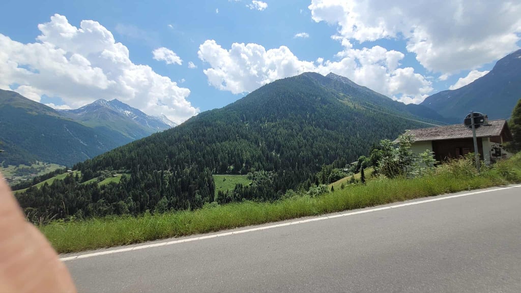
Once you reach the junction that leads to Vercorin, the road is beautiful (and I recommend descending along this road) and the sun is beating down at 100%. Don't go all out because this is just the 1st ascent, which is 14km long (including the future descent). The road to Vercorin offers its share of magnificent views! You won't remember it being particularly difficult, but it's not easy or horrible.

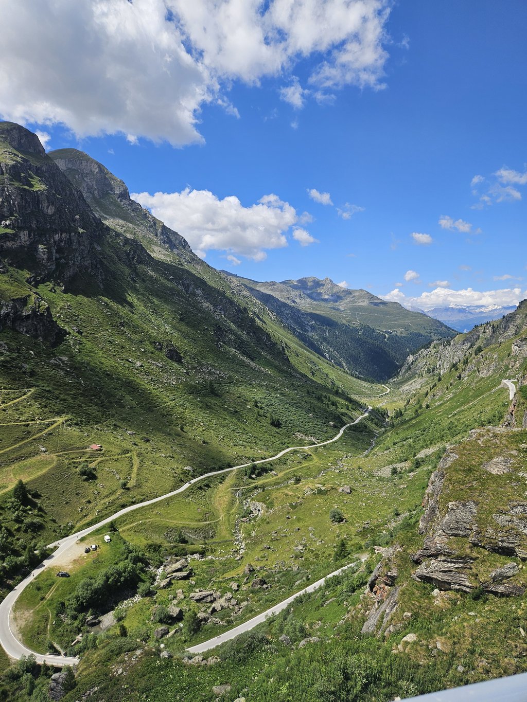
But once the descent is done, head for Brientz, your head and your eyes will take plenty of cranks ^^ Once past Brientz, don't hesitate to stop at the Coop to buy some food because the hardest part is yet to come. 5km at an average of 9% with peaks at 14 and 15%, it's endless. This is where the length of the climb starts to take its toll. Hang on, you can do it!

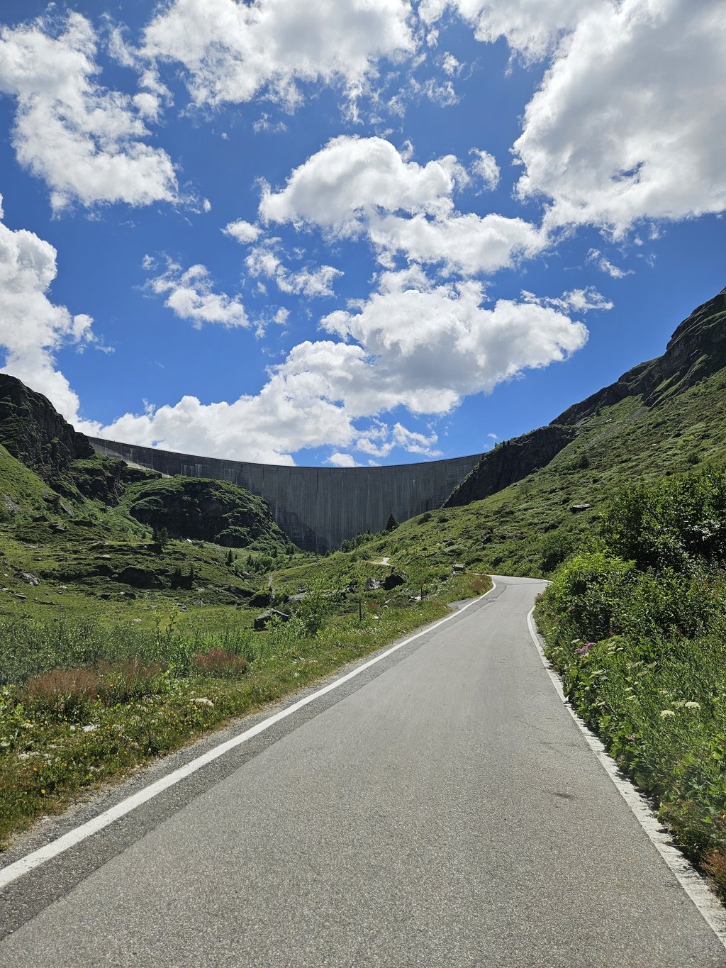
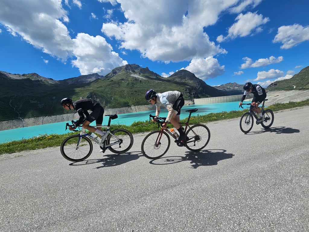
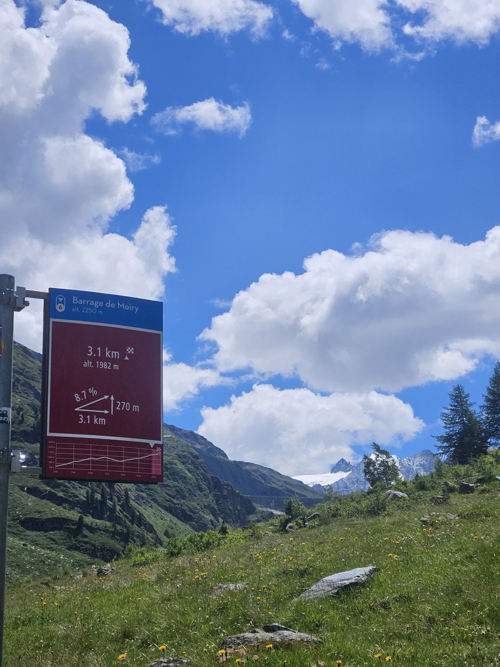
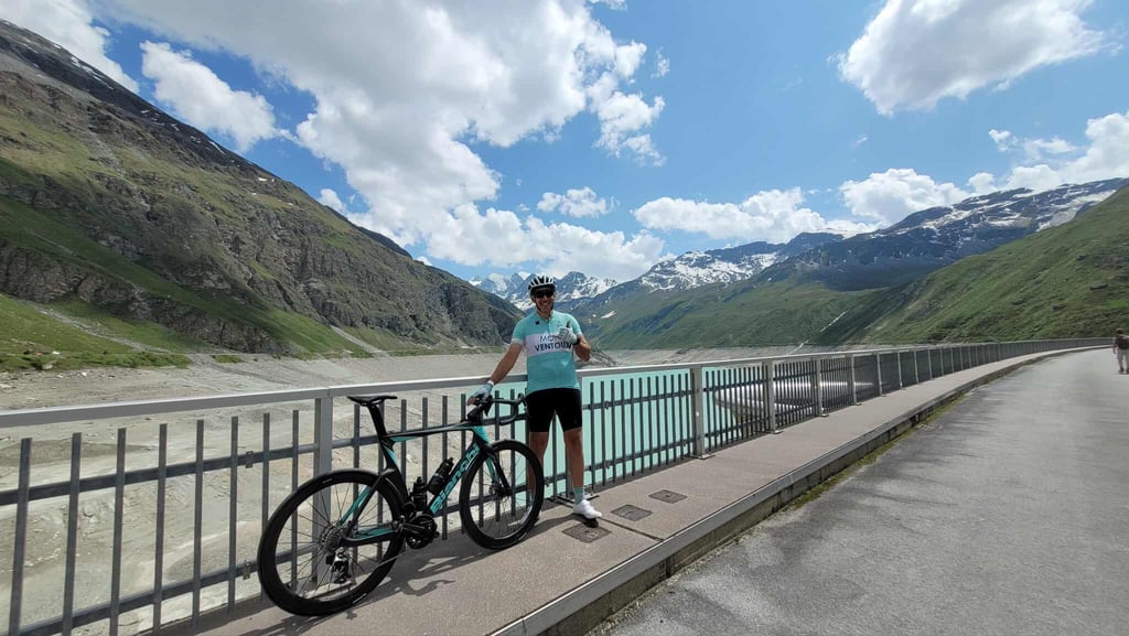
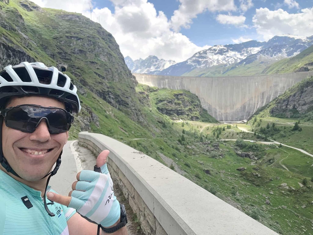
The ultimate pleasure = when you see the dam....the ultimate pain = the last two km... it's super steep again and you're delivered when you see the tunnel. PS: the tunnel is scary because it's steep and naturally wet. If you're lucky, there will be cars coming down, so ask them to shine their lights on you if you don't have a headlamp.

But once you're up there: the view is immense. Just before too :-)

Stéphane Matter / 1m85 90kg

Montée effectuée le 21 juin 2025 avec Ride The Alps que l'on peut remercier pour avoir fermé les routes! Alors que vous dire : soyez endurants! Ayez une cassette minimum dent de 34 ou 36. Ou alors soyez grimpeur ^^ Tout commence dans la rampe de lancement par Chippis ou vous êtes en prise. Cette prise la va durer jusqu'à la première fontaine que vous verrez comme un salut..Vous allez passer par des % à deux chiffres bien plus souvent qu'on ne le pense. Le % moyen est tout sauf régulier avec des pics à 15% et une route en piteux état. Je ne conseille pas de descendre par le début de l'ascension car la route est vraiment défoncée.

Arrivé dans la jonction qui mène à Vercorin, la route est belle (et je conseille de descendre par cette route la) et le soleil cogne à 100%. Partez pas à fond car la c'est que la 1ère ascension qui fait 14km (y compris la futur descente). La route qui mène à Vercorin offre son lot de point de vue qui est magnifique! Pas de souvenir de difficulté hors norme, elle passe sans pour autant être facile ou horrible.

Mais une fois la descente faite, direction Brientz, la votre tête et vos yeux vous en prendre plein les manivelles ^^ Une fois Brientz passer, hésitez pas à vous arrêter à la Coop pour acheter à manger car le plus dur reste à venir. 5km à 9% de moyenne avec des pic à 14 et 15%, la c'est interminable. C'est la ou la longueur de l'ascension commence à peser. Accrochez-vous vous en êtes capable!

Summum du jouissif = quand vous voyez le barrage....summum de la douleur = les deux derniers km... c'est de nouveau super raide et la délivrance quand vous voyez le tunnel. PS : le tunnel fait peur car il est pentu et naturellement mouillé. Si vous avez de la chance, y'aura des voitures qui descendront et bien demander leur de vous éclairer si vous n'avez pas de lampe frontale.

Mais une fois la haut : la vue est immense. Juste avant également :-)

Stéphane Matter / 1m85 90kg

Barrage de Moiry from Chippis via Briey
Dashboard
LorenzoGbr
11 Mo 5.0

Watch out for the rocky sides in Vercorin (encountered while climbing) and on the downhill section to Mayoux. There are often pebbles and loose rocks in the middle of the road.
Nothing to add on the climb itself, this variant is a little more leg-breaking due to the downhill in the middle.

Dashboard
ZachW
1 y 5.0

Awe inspiring climb. The dam appears around a corner with three kms to go and looks entirely unassailable. The first climb is mostly switchbacks on a small road through quiet vineyards. While the road surface isn't perfect, it gets the job done. After Briey you join a larger road which is much smoother but a bit more trafficked. A tiny descent after Vercorin leads to couple kilometers of very scenic climbing before a surprisingly difficult descent Mayoux. This descent terminates very abruptly in a sharp turn uphill and after flying for a few kilometers you'll feel as though you're moving through molasses uphill. Another note on the descent: while it is represented here as a "two kms at 1%" this doesn't embody the feel at all, as it is better broken down as 1k of -5% and another at 6%. The climb Mayoux to Grimentz is both beautiful and best not to be taken too hard. This is an exceptionally long climb, which is something you really only start to feel when you get through Grimentz and still have 8 steep kilometers to go. Especially the four or so kilometers out of Grimentz was when I started to feel the kind of fatigue and soreness in my legs that begin to make even the gentle grades feel difficult. There are of course, also no gentle grades so that too adds to the difficulty. After 5kms the barrage rises up to impede your path up the valley and, ploting the trajectory mentally you'll reach the inevitable conclusion that reaching the top will necessitate a massive change increase in gradient. It does. This single switchback which takes you from the base to the top of the dam also has at least a kilometer to eye you down from its place up on the side of the mountain. It also runs directly into a tunnel, which shrouds its exact distance. The first section of switchback is quite steep and likely the hardest part of the whole day. After turning, you head toward the mouth of the tunnel. Once inside, the exit appears as a small, somewhat distant speck of light well above you. If not for the pain this would be quite funny as a literal light at the end of the tunnel but one shouldn't be begrudged too greatly for not finding the humor in the moment. Although it feels at first like the light will never get closer it inevitably does and your view is opened onto a vast, intenselyblue lake. Go get a tart at the adjoining restaurant and have a nice look out over the water, or over the enormous height of the valley below.

Barrage de Moiry from Chippis via Briey
Dashboard
richy
2 y 5.0
This is an automatic translation, the original language is: French. Show original

Another route up the Val d'Anniviers that is much less busy than the one to Vissoie. It adds a bit of elevation gain as you pass through Vercorin, but also a nice, fairly technical descent to reach Mayoux before heading back up towards Grimentz to get to the dam and its famous final ramp, which alone is worth the climb!

Une autre route pour monter leVal d'Anniviers qui est beaucoup moins fréquentée que celle de Vissoie. Sa rajoute un peu de dénivelé car on passe par Vercorin mais aussi une jolie descente assez technique pour rejoindre Mayoux avant de remonter direction Grimentz pour aller chercher le barrage et sa fameuse ultime rampe qui vaut a elle seule de faire cette montée!

Dashboard

Climbing times

5 mph 04:03:49
7 mph 02:52:37
9 mph 02:14:31
12 mph 01:41:04

Road surface condition

100% 0% 0%
Based on 1 vote
Share your knowledge. What was the road condition during your ascent?

Traffic

100% 0% 0%
Based on 1 vote
Your experience counts. How much traffic did you encounter during the climb?

Frequently Asked Questions

Barrage de Moiry can be cycled from 3 sides. Barrage de Moiry from Sierre via Grimentz is the most popular side, but the summit can also be reached via Barrage de Moiry from Chippis via Briey & Barrage de Moiry from Zinal.

The Barrage de Moiry from Chippis via Briey is extremely hard. We recommend that you choose the lightest possible gearing, such as a 34-tooth or smaller chainring, combined with a 34-tooth rear cog. Otherwise, there's a good chance you'll need to put a foot down sooner or later. If you think you need to go even lighter, you could consider using a gravel or mountain bike, or installing a gravel or mountain bike derailleur with a rear cog of more than 40 teeth. Good luck!

Barrage de Moiry from Chippis via Briey falls into the Super Hors Catégorie, the absolute top category. These are the most extreme climbs that exist. Even with excellent fitness, there is a chance you will have to put a foot down. Only the strongest make it to the top without any problems.

Barrage de Moiry from Chippis via Briey is 20.2 mi long.

The average gradient of Barrage de Moiry from Chippis via Briey is 6.3%.

Barrage de Moiry from Chippis via Briey has a steepest segment with an average gradient of 17.3%.

The summit of Barrage de Moiry from Chippis via Briey is at 7480 ft.

At a slow pace of 5 mph, it takes about 04:03:49 to climb Barrage de Moiry from Chippis via Briey. At 7 mph the time is 02:52:37, and at 9 mph 02:14:31. For the fastest cyclists, 01:41:04 is an achievable time.

Barrage de Moiry from Chippis via Briey is located in the region Valais in Switzerland.

This page is better in the app

Climbfinder app
Climbfinder
(Free)
Open