Hotond is a climb in the region Flemish Ardennes. It is 2.7 km long and bridges 110 m of vertical ascent with an average gradient of 4.1%, resulting in a difficulty score of 88. The top of the ascent is located at 150 m above sea level. Climbfinder users shared 9 reviews of this climb and uploaded 2 photos.
Road names: Oudestraat, Kruisstraat, Kruisstraat & Zandstraat
3.0 by LarsG13This is an automatic translation, the original language is: Dutch.The Kruisberg is tough, but after that it’s all quite manageable, although it’s a busy road once you’ve passed the traffic lights.... read more
Welcome! Please activate your account if you would like to share something. Look for the verification email in your inbox.
If you want to upload your photos, you need to create an account. It only takes 1 minute and it's completely free.
The Kruisberg is tough, but after that it’s all quite manageable, although it’s a busy road once you’ve passed the traffic lights.
De kruisberg is zwaar, erna allemaal goed te doen, wel drukke baan vanaf je voorbij de lichten bent.
The famous helicopter view from the Tour of Flanders. You first go over the cobbles of the old Kruisberg.
Het bekende helikopter beeld vanuit de ronde van vlaanderen. Je gaat eerst over de kasseien van de oude kruisberg.
I actually rode the second half of this towards Hotond (coming from the Rijksweg) before getting to town and doing the Oude Kruisberg, so a bit of a different effort than what this version of Hotond is about...however, having still combined the two somehow: this is a great combo.
Especially the last 1km or so, with the nice forest as background, is really enjoyable. The gradients aren't crazy and you can leverage the slight downhill just before that forest bit to give yourself some momentum,
Typical Flemish Ardennes climb with a somewhat irregular course. The trickiest part is in the beginning on the cobbles of the Oude Kruisberg, where it is difficult to get into a good rhythm right away. It then changes to asphalt and continues to climb slightly up to the top. Along the way, traffic lights can still interrupt your pace.
Not the prettiest climb, but with the combination of cobbles, asphalt and the finish at the mill, it's one you must have ridden once.
Typische Vlaamse Ardennen-klim met een wat onregelmatig verloop. Het lastigste stuk zit in het begin op de kasseien van de Oude Kruisberg, waar het moeilijk is om meteen in een goed ritme te komen. Daarna gaat het over op asfalt en blijft het nog licht oplopen tot aan de top. Onderweg kunnen verkeerslichten je tempo nog onderbreken.
Niet de mooiste klim, maar door de combinatie van kasseien, asfalt en de aankomst bij de molen wel eentje die je eens gereden moet hebben.
After dawdling on the Oude Kruisberg, you gasp for breath, but you don't get time to recover, as it keeps mounting. Just when you are recovering a bit, you have to reckon with the lights. Not ideal, in the middle of a climb. As far as I'm concerned, there are much more interesting climbs on and around the Hotond.
Na het gesukkel op de Oude Kruisberg, hap je naar adem, maar je krijgt geen tijd om te bekomen, want het blijft oplopen. Net wanneer je wat aan het bekomen bent, moet je rekening houden met de lichten. Niet ideaal, midden een klim. Wat mij betreft, zijn er veel interessantere klimmetjes op en rond de Hotond.
Pretty crowded but a nice running climb. Cobblestones on Old Kruisberg are worse than expected
Vrij druk maar een mooie lopende klim. Kasseien op Oude Kruisberg liggen slechter dan verwacht
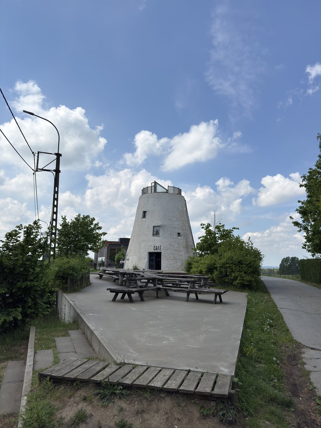
The Kruisberg is definitely not one of my favourite climbs. I ride it once a year 'mandatory' in April but the rest of the year I avoid it. The cobbles are bad and it is hard to find a rhythm. Once you get to the top it then improves and the climb is via good tarmac over slight percentages. However, you still come to a crossroads with traffic lights along the way that completely break your rhythm. At the top of the Hotond, you come to the distinctive mill. Because of its cycling history, it still gets a 5. Some hills you just have to have done.
De Kruisberg is zeker niet één van mijn favoriete beklimmingen. Ik rijd er één keer per jaar 'verplicht' op in april maar de rest van het jaar vermijd ik het. De kasseien liggen slecht en het is moeilijk een ritme te vinden. Eens je boven komt gaat het dan beter en is het klimmen via goed asfalt over lichte percentages. Je komt echter onderweg nog aan een kruispunt met verkeerslichten die volledig je ritme breken. Bovenaan de Hotond kom je aan de kenmerkende molen. Vanwege de wielergeschiedenis krijgt ie toch een 5. Sommige hellingen moet je gewoon gedaan hebben.
It was only when I suddenly saw the mill pub looming that I realised I was on the Hotond. For me, one of the most characteristic images from Dwars door Vlaanderen and the Ronde. Had to get off the bike for a moment to take a photo.
Pas toen ik ineens het molencafé zag opdoemen realiseerde ik me dat ik al op de Hotond was. Voor mij een van de meest kenmerkende televisiebeelden uit Dwars door Vlaanderen en de Ronde. Moest even van de fiets om een foto te maken.
First up the cobblestones of the Oude Kruisberg, which are still a better alternative than the main road from Ronse. Then you may well have to wait at the traffic lights before finishing the rest of the climb on the left. Most difficult at the start and not really beautiful or special otherwise. The Hotond may be the highest point in East Flanders, but otherwise I think it's just a weak climb.
Eerst de rotkasseien van de Oude Kruisberg op die toch nog altijd een beter alternatief zijn dan de grote baan vanuit Ronse. Dan kan het goed zijn dat je aan het verkeerslicht moet wachten voor je links de rest van de beklimming af kan werken. Het moeilijkste in het begin en voor de rest niet echt mooi of speciaal. De Hotond is dan wel het hoogste punt van Oost-Vlaanderen, voor de rest vind ik het maar een inspiratieloze klim.
| 7 km/h | 00:22:56 |
| 11 km/h | 00:14:35 |
| 15 km/h | 00:10:42 |
| 19 km/h | 00:08:27 |
This page is better in the app