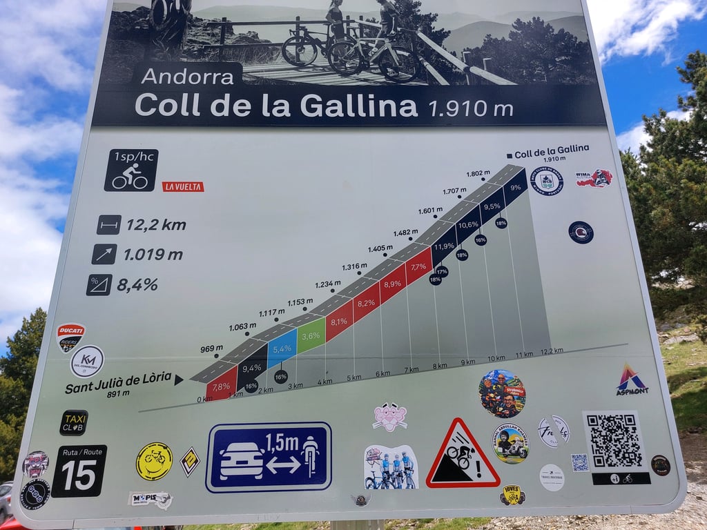
Coll de la Gallina from Sant Julià de Lòria is a climb in the region Parishes of Andorra. It is 7.5 mi long and bridges 3451 ft of vertical ascent with an average gradient of 8.8%, resulting in a difficulty score of 1015. The top of the ascent is located at 6270 ft above sea level. Climbfinder users shared 3 reviews of this climb and uploaded 8 photos.
Road names: Carretera de Fontaneda, CS-140 & Carretera de la Collada de la Gallina
5.0 by MorellinoThis is an automatic translation, the original language is: Dutch.Officially the toughest climb in Andorra so I, a reasonably well-trained cyclist of 53 years, 72 kg, was keen to cycle it. I set off from campsite Fons de Ferrocins near Soldeu at an altitude of over 1800 metres. The first 20 km to the foot of the climb are almost entirely downhill from east to west Andorra on the country's only through road. It was hot (33°C) and crowded with cars's up to the foot of the climb. Lots of exhaust fumes. A terrible stretch to cycle I found, including thr... read more

Welcome! Please activate your account if you would like to share something. Look for the verification email in your inbox.
If you want to upload your photos, you need to create an account. It only takes 1 minute and it's completely free.
A legendary mountain pass that’s become very popular among cyclists and participants in the La Purito cycling tour. It’s a pretty good climb—it’s long, but once you pass the dairy farm, you’ll need to psych yourself up for the last 5–6 km or so because it’s quite a challenge. Once you’re at the top, smile—you’ve just hit the jackpot!🔥🔥🔥
Mítico puerto muy popularizado, por ciclistas y la ciclo Turista La Purito. Puerto bastante bueno es largo pero una vez pasada la vaquería los últimos 5-6 km aprox has de mentalizarte bien porque tira bastante. Una vez arriba sonríe porque te has marcado una gallina con los huevos de oro🔥🔥🔥
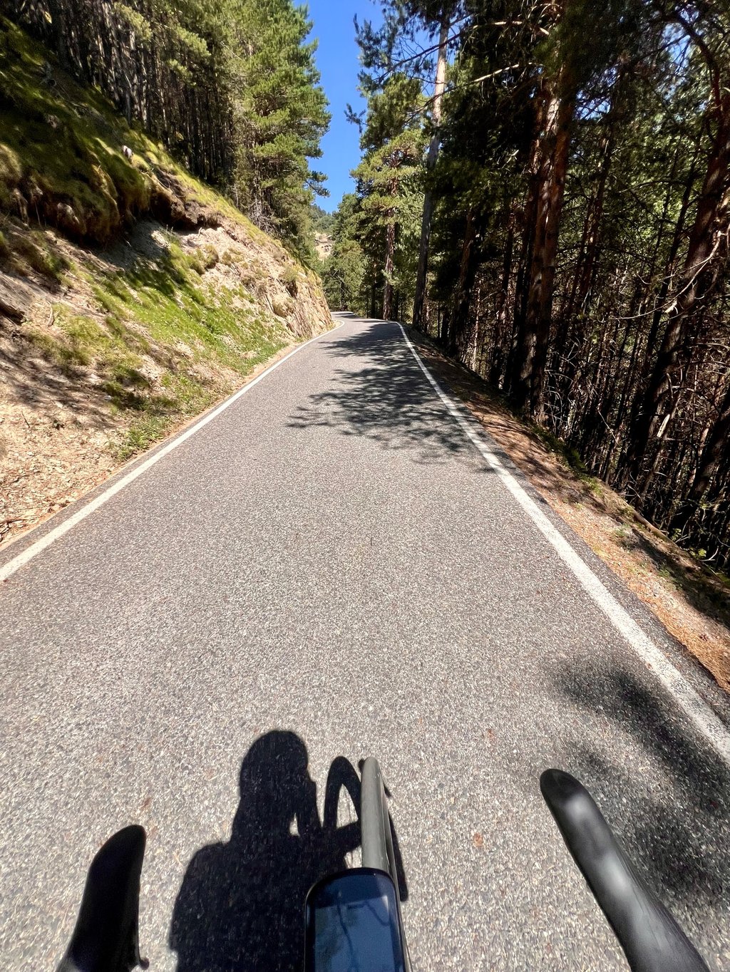
Andorra's toughest climb. This is quite a struggle, but a beautiful climb. The toughest part is between km 8 and 10, There the road narrows and is one-way until the top. As soon as the road narrows it becomes extremely hard. These 2 km have an average of above 10, but because it is somewhat uneven, you get several sections of 16, 17 and even 18%. Then again, the last 2 km are a little more digestible. The descent is also beautiful. When you get to the main road after the descent (just at the bridge over the water), left and 50 meters further on the right the Aixas. (Definitely worth it if you still have strength left.
De zwaarste klim van Andorra. Dit is een hele kluif, maar een prachtige klim. Het zwaarste gedeelte is tussen km 8 en 10, Daar versmalt de weg en is het eenrichtingsverkeer tot aan de top. Van zodra de weg versmalt wordt het enorm zwaar. Deze 2 km hebben een gemiddelde van boven de 10, maar doordat het wat ongelijkmatig is, krijg je verschillende stukken van 16, 17 en zelfs 18%. De laatste 2 km zijn dan weer iets beter verteerbaar. De afdaling is ook prachtig. Wanneer je na de afdaling op de grote weg komt (net aan de brug over het water), links en 50 meter verder rechts de Aixas. (Zeker ook de moeite als je nog krachten over hebt.
Officially the toughest climb in Andorra so I, a reasonably well-trained cyclist of 53 years, 72 kg, was keen to cycle it. I set off from campsite Fons de Ferrocins near Soldeu at an altitude of over 1800 metres. The first 20 km to the foot of the climb are almost entirely downhill from east to west Andorra on the country's only through road. It was hot (33°C) and crowded with cars's up to the foot of the climb. Lots of exhaust fumes. A terrible stretch to cycle I found, including through the capital La Vella, but there is no alternative.
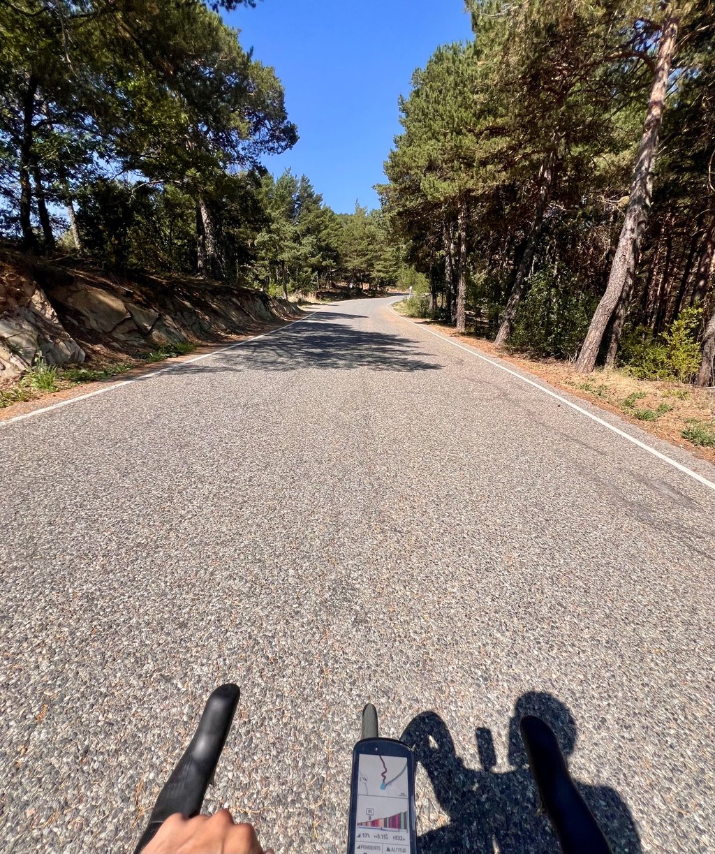
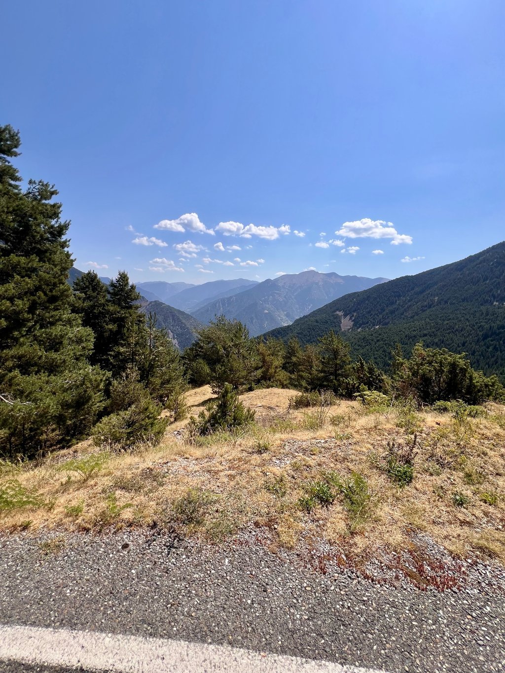
From the foot of the climb in Sant Julià de Lòria, everything becomes different. A beautiful, well-paved road in an oasis of calm winds inexorably steeply uphill. I encountered no other cyclists and only a few cars's. The profile promised a tough ride beforehand and it became so. Especially as the climb got tougher towards the end. The last 4 km were 11.9, 10.4, 9.5 and 9.2 per cent according to the signs along the road. And there are really steep sections in there, up to 16 per cent on my Bryton. I largely raked uphill on my lightest gear 32-30. But oh how beautiful it was. At the summit at over 1900 metres, a couple of benches and stunning views. Incidentally, I didn't see any water taps anywhere, whereas there are elsewhere in Andorra. Probably missed them because of the suffering.
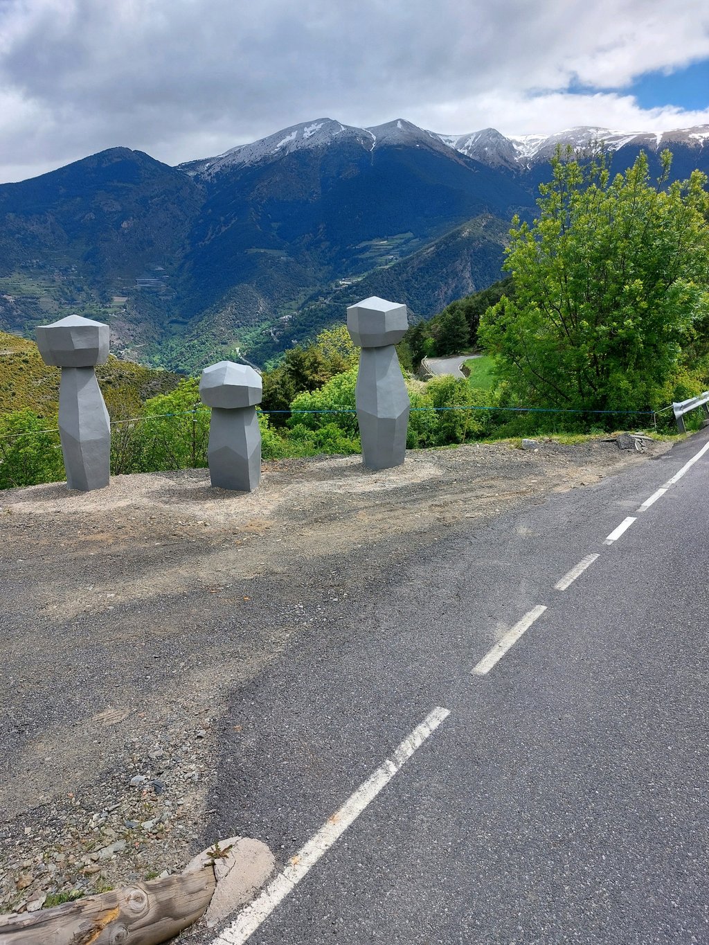
The descent on the other side of the col was equally beautiful and on good tarmac. In short, highly recommended if you like tough climbing but better not with this heat. On my way back to the campsite on the same bloody hot and muggy tarmac road, I got so heated that I decided to stop. By the way, this road is the start of the ascent to the Port de Envalira (https://climbfinder.com/nl/beklimmingen/port-d-envalira-andorre-la-vella) so goes uphill continuously, averaging 5-6 per cent but with regular stretches of 7-10 per cent. Not to be underestimated. The climb to Port de Envalira was popular (you then go to France) but as it goes entirely along the main road, I wouldn't like to cycle it myself.
Officieel de zwaarste klim van Andorra dus die wilde ik, een redelijk goed getrainde fietser van 53 jaar, 72 kg, graag fietsen. Ik vertrok vanaf camping Fons de Ferrocins bij Soldeu op ruim 1800 meter hoogte. De eerste 20 km tot aan de voet van de klim gaan vrijwel geheel bergaf van oost naar west Andorra over de enige doorgaande weg van het land. Het was heet (33°C) en druk met auto's tot aan de voet van de klim. Veel uitlaatgassen. Een vreselijk stuk om te fietsen vond ik, onder andere door de hoofdstad La Vella, maar er is geen alternatief.
Vanaf de voet van de klim in Sant Julià de Lòria wordt alles anders. Een prachtige, goed geasfalteerde weg in een oase van rust slingert onverbiddelijk steil omhoog. Ik ben geen andere fietsers tegengekomen en slechts een paar auto's. Het profiel beloofde op voorhand een zware kluif en dat werd het ook. Vooral omdat de klim naar het einde toe steeds zwaarder wordt. De laatste 4 km waren volgens de bordjes langs de weg 11.9, 10.4, 9.5 en 9.2 procent. En er zitten echt steile stukken in, op mijn Bryton tot wel 16 procent. Ik ben grotendeels op mijn lichtste verzet 32-30 naar boven geharkt. Maar oh wat was het mooi. Op de top op ruim 1900 meter een paar bankjes en een schitterend uitzicht. Overigens heb ik nergens watertappunten gezien, terwijl die er elders in Andorra wel zijn. Waarschijnlijk gemist door het afzien.
De afdaling aan de andere kant van de col was al even mooi en op goed asfalt. Kortom, een echte aanrader als je van zwaar klimmen houdt maar beter niet met deze hitte. Op mijn weg terug naar de camping over dezelfde bloedhete en benauwde asfaltweg raakte ik zo verhit dat ik besloot te stoppen. Deze weg is trouwens het begin van de beklimming naar de Port de Envalira (https://climbfinder.com/nl/beklimmingen/port-d-envalira-andorre-la-vella) dus gaat continu bergop, gemiddeld met 5-6 procent maar met regelmatig stukjes van 7-10 procent. Niet te onderschatten. De klim naar Port de Envalira was populair (je gaat dan naar Frankrijk) maar aangezien deze volledig langs de grote weg gaat zou ik deze zelf niet graag fietsen.
| 5 mph | 01:30:06 |
| 7 mph | 01:03:47 |
| 9 mph | 00:49:42 |
| 12 mph | 00:37:20 |
This page is better in the app