Colle dell'Agnello is a climb in the region Cuneo. It is 31.6 km long and bridges 1789 m of vertical ascent with an average gradient of 5.7%, resulting in a difficulty score of 1416. The top of the ascent is located at 2744 m above sea level. Climbfinder users shared 29 reviews of this climb and uploaded 38 photos.
Road name: SP251
5.0 by KevinThis is an automatic translation, the original language is: Dutch.The last 10 km or so are extremely tough. Fortunately, the steep pentes are regularly broken by numerous hairpin bends. Moreover, there is enough distraction by the magnificent setting. At the top, you are treated to an amazing view!... read more
Welcome! Please activate your account if you would like to share something. Look for the verification email in your inbox.
If you want to upload your photos, you need to create an account. It only takes 1 minute and it's completely free.
The Colle dell'Agnello...
A tough climb that leaves few metres of respite, plus the last 10 km (the toughest) are completely in the sun making things even tougher.
I advise you not to look at the signs indicating the gradient of the road, the one indicating 14% is the worst of the worst... nor get carried away by counting the kilometres to the top.
Not recommended for weekends because of the heavy traffic (watch out for motorbikes and especially campers!).
Il Colle dell'Agnello...
Salita dura che lascia pochi metri di tregua, per di più gli ultimi 10 km (i più duri) sono completamente al sole rendendo le cose ancora più dure.
Consiglio di non guardare i cartelli indicanti la pendenza della strada, quello indicante 14% è il peggio del peggio... neppure lasciarsi trascinare dal conteggio dei chilometri che mancano alla cima.
Sconsigliato il transito nei week-end a causa dell'intenso traffico (occhio alle moto e soprattutto ai camper!)
One of the most historic climbs in Piedmont, to be done at least once in a lifetime, perhaps taking advantage of the organised day with roads closed to motor vehicles that is usually held in early September.
Hard slopes that never let up.
Una delle salite più storiche in Piemonte, da fare almeno una volta nella vita magari sfruttando l'occasione della giornata organizzata con strade chiuse a veicoli a motori che di solito si tiene ad inizio Settembre.
Pendenze dure che non mollano mai.
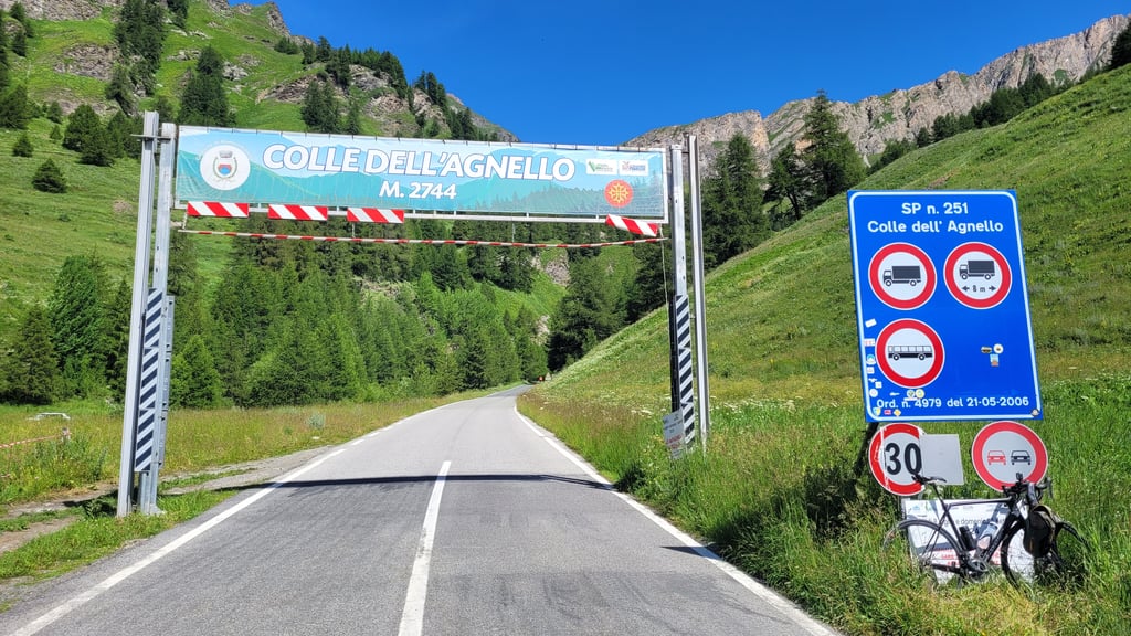
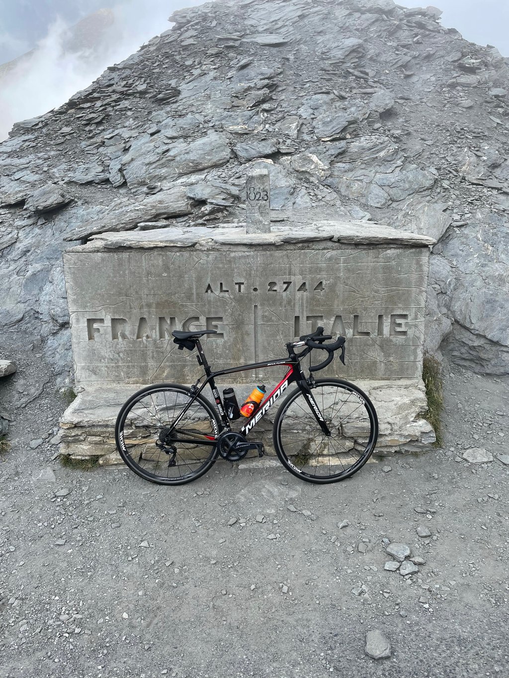
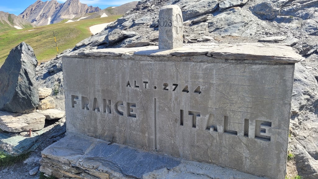
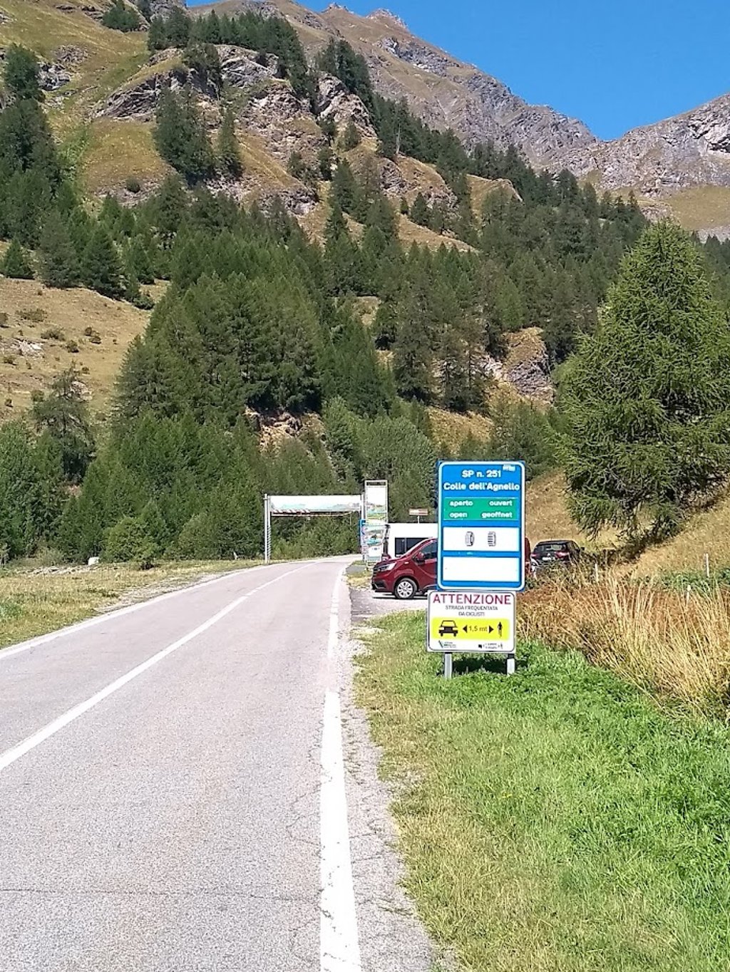
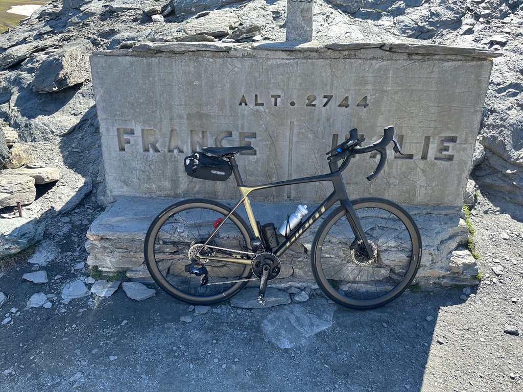
The Colle dell'Agnello, on the Italian side from Casteldelfino, is one of the toughest climbs in the Alps. First of all, it should be noted that after the Col d'Iseràn and the Passo dello Stelvio, it is the highest paved pass in Europe, and there is only a slight difference of a few metres between them. The Agnello Pass reaches 2744 metres above sea level, 14 less than the Stelvio Pass and 26 less than the Col d'Iseràn.
From Casteldelfino, it is 20.7 kilometres long, has an altitude difference of 1,458 metres, with an average gradient of 7 per cent, rising to 9.3 per cent in the last 10 kilometres and a maximum gradient of 15 per cent.
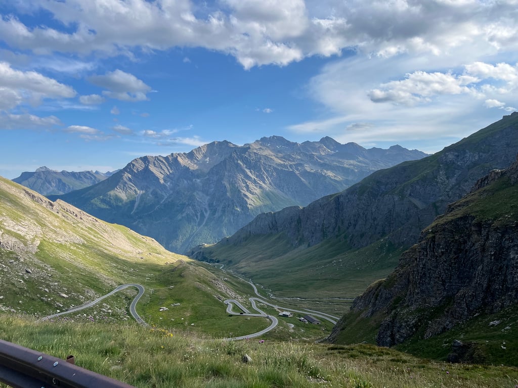
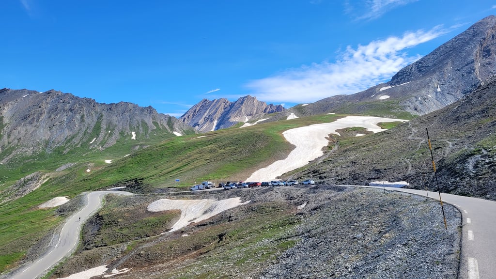
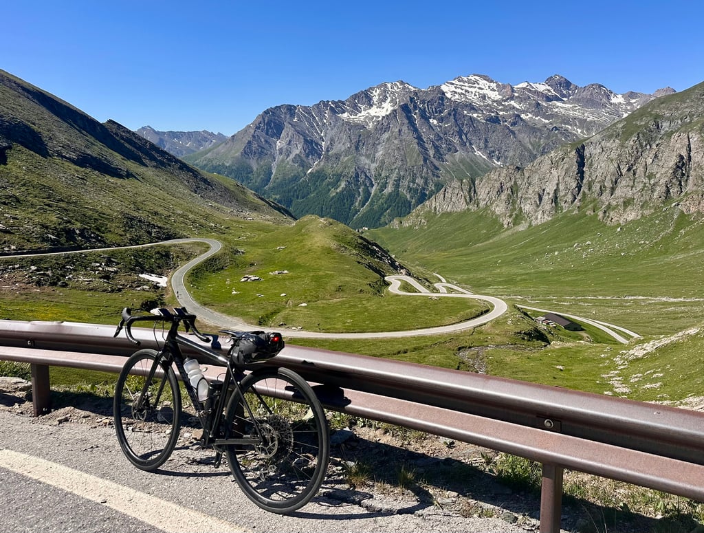
Up to Pontechianale, the last village before the summit, there are short, uneven ramps and a few demanding hairpin bends.
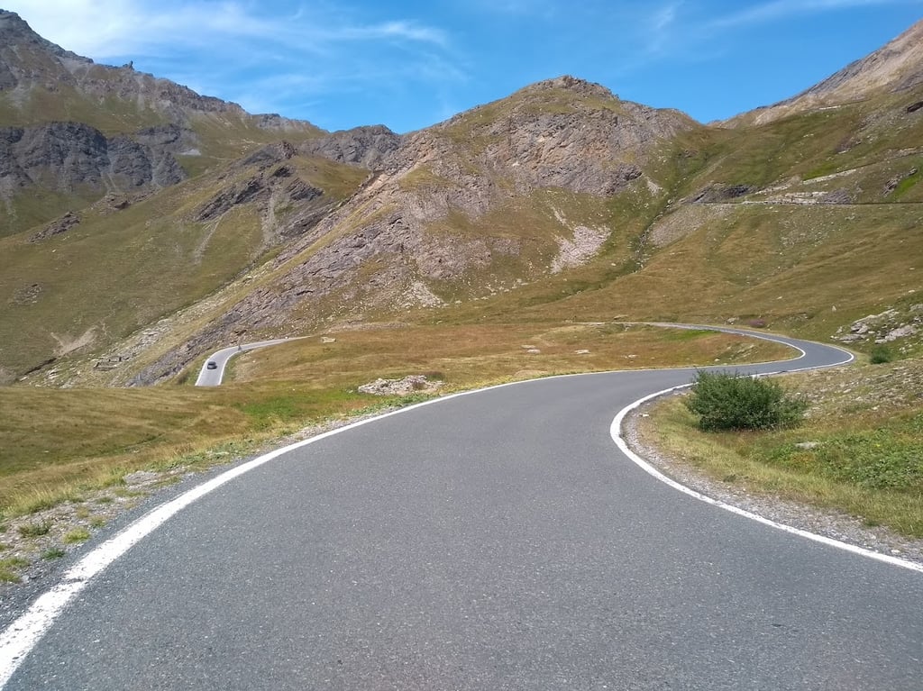
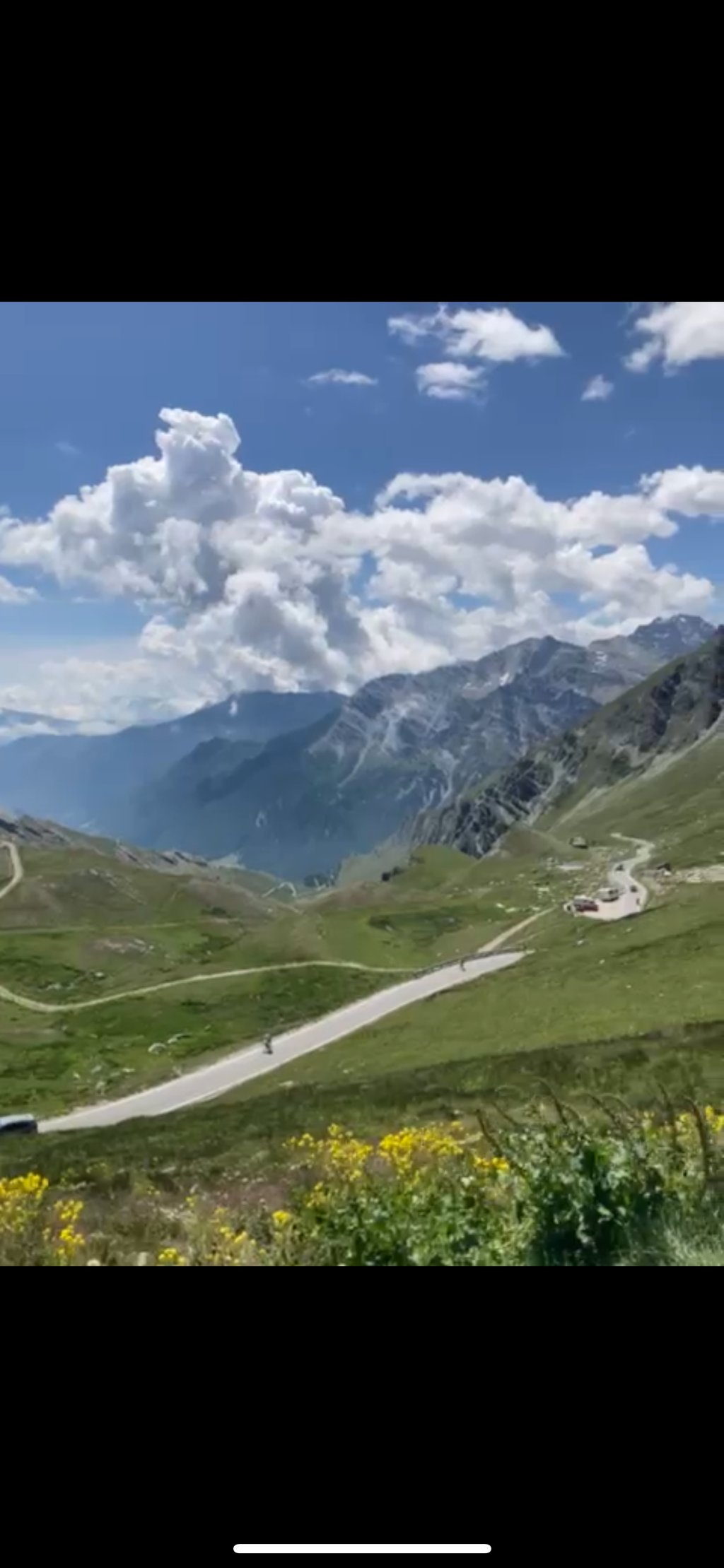
After skirting the lake and reaching the village of Chianale, passing the old customs post and reaching the arch celebrating the climb, there are about 10 kilometres to the summit but you are still at 1850 metres above sea level. Mathematics being an exact science, the cyclist finds himself facing the last stretch with an average gradient of 10 per cent, long stretches at 12 per cent with peaks of up to 15 per cent and no chance to catch his breath, except for a hundred or so metres at the Pian dell'Agnello.
A hellish segment made even tougher by the altitude and the wind, which can be annoying as well as cold at those altitudes. The hardness of the climb has no mercy for the cyclist: in addition to the legs and heart, one climbs with the strength of the mind and experience in managing one's strength is fundamental.
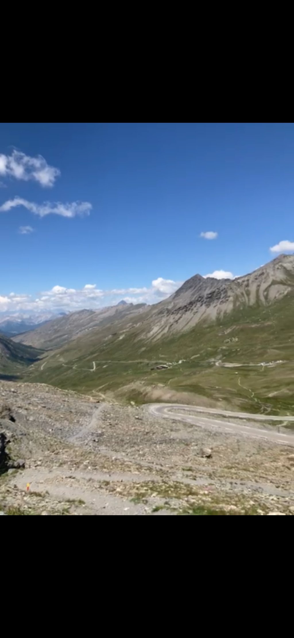
The Col dell'Agnello, especially in the last section, is in essence an endless ramp. It does not allow a moment's respite and seems like a sort of endless apnoea with the legs always under strain and the back and arms in constant tension.
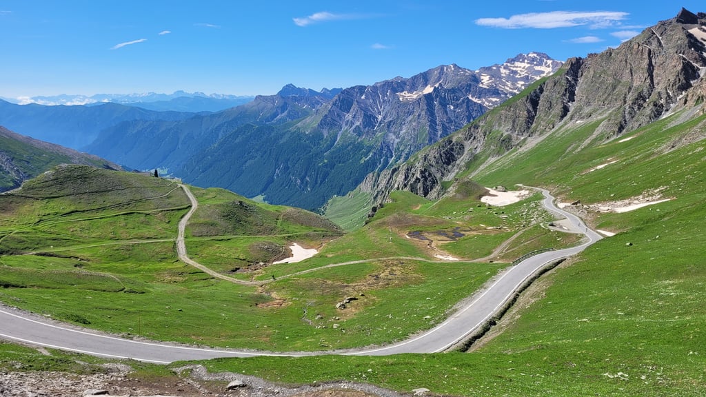
It is useless to mention the splendid views that are offered to the cyclist's eyes clouded by fatigue, and I recommend always paying attention to vehicular and motorbike traffic, with cars and motorbikes whizzing by at licence-withdrawal speeds, brushing past the cyclist already exhausted by the effort to stay focused and manage his strength.
Once at the top, one is amply repaid for the effort expended. Apart from the chaos of the numerous motorcyclists present, noisy, annoying and uneducated to the silence that the mountains and spectacular views would impose, one cannot help but be fascinated by the view of what surrounds the pass and the photos at the end of the video are more eloquent than many words.
As usual, in ventures of this kind, one no longer has the desire to turn back: fortunately, new challenges await and, in our case, the Colle di Sampeyre from Sampeyre, but that is another venture to recount.
After looking around, we pay homage to great beauty and this video wanted to celebrate its most significant and intimate moment through the sacrifice on the severe and inclement altar of the pass.
Il Colle dell'Agnello, versante italiano da Casteldelfino, è da annoverare tra le salite più dure dell'arco alpino. Bisogna innanzitutto tener presente che dopo il Col d'Iseràn e il Passo dello Stelvio è' il passo asfaltato più alto d'Europa e tra loro c'è una differenza minima di qualche metro. Il Colle dell’Agnello raggiunge i 2744 metri sul livello del mare, 14 in meno del Passo dello Stelvio e 26 del Col d’Iseràn.
Da Casteldelfino, la lunghezza è di 20,7 chilometri, presenta un dislivello d 1458 metri, con una pendenza media del 7 per cento, che sale al 9,3 per cento negli ultimi 10 chilometri e una pendenza massima del 15 per cento.
Fino a Pontechianale, ultimo paese prima della cima, si affrontano brevi e discontinue rampe e qualche tornante impegnativo.
Dopo aver costeggiato il lago e raggiunto il villaggio di Chianale, superata la vecchia dogana e raggiunto l’arco celebrativo della salita, mancano circa 10 chilometri alla cima ma si è ancora a quota 1850 metri sul livello del mare. Essendo la matematica una scienza esatta, il ciclista si ritrova ad affrontare l’ultimo tratto con pendenza media del 10 per cento, lunghi tratti al 12 per cento con punte fino al 15 per cento e nessuna possibilità di prendere fiato, se non per un centinaio di metri al pian dell’Agnello.
Un segmento infernale reso ancor più duro dall’altitudine e dal vento che può essere fastidioso oltre che freddo a quelle altitudini. La durezza della salita non ha pietà del ciclista: oltre che con le gambe e il cuore, si sale con la forza della mente e risulta fondamentale l'esperienza nella gestione delle forze.
Il colle dell'Agnello soprattutto nell'ultimo tratto è in sostanza una rampa senza fine. Non concede un attimo di tregua e sembra una sorta di apnea infinita con le gambe sempre sotto sforzo e schiena e braccia in continua tensione.
E’ inutile menzionare gli splendidi panorami che si offrono alla vista del ciclista offuscata dalla fatica e consiglio di prestare sempre attenzione al traffico veicolare e motociclistico, con auto e moto che sfrecciano a velocità da ritiro della patente, sfiorando il ciclista già provato dallo sforzo di restare concentrato a rimanere lucido e a gestire le forze.
Una volta in cima, si è ripagati ampiamente dallo sforzo profuso. A parte il caos dei numerosi centauri presenti, chiassosi, fastidiosi e ineducati al silenzio che le montagne e le viste spettacolari imporrebbero, non si può non restare affascinati dalla visione di ciò che circonda il passo e le foto al termine del video sono più eloquenti di tante parole.
Come al solito, in imprese del genere, non si ha più la voglia di tornare indietro: fortunatamente nuove sfide attendono e, nel nostro caso, il Colle di Sampeyre da Sampeyre, ma è un’altra impresa da narrare.
Dopo esserci guardati intorno, si rende omaggio alla grande bellezza e questo video ne ha voluto celebrare il momento più significativo e intimo attraverso il sacrificio sull'altare severo e inclemente del passo.
After cycling up the beautiful French side, the same day (25/08/25) I also climbed the final part of the Italian side of this literally cross-border col from Chianale. The picturesque traffic-free village where the inhabited world ends and the last leaden 10 km start firmly uphill.
The "flat part" here abruptly encounters steep rock faces but the route is nicely laid out so that you only need 3 hairpin turns to reach the level of the treeless upper valley. Road signs along the way alert you to two straight 14% sections.
You cycle without much traffic on fine road in an impressive rugged mountain scenery with very active marmots.
Unlike the other side, there was a strong wind that day, blowing at times into the back thanks to the curves.
The descent ends on a windy cold summit plateau with the familiar wide border post and fabulous views of the two climbing sides.
For me personally, it is the toughest of all the passes between France and Italy, but also the most beautiful with a slight preference for this side.
HIGH / SLOW / Gorgeous are three words that perfectly describe the Colle dell'Agnello!
Unique experience!!!
Na het opfietsen van de fraaie Franse zijde, dezelfde dag (25/08/25) ook het slotdeel van de Italiaanse kant van deze letterlijk grensoverschrijdende col beklommen vanaf Chianale. Het pittoresk verkeersvrij dorpje waar de bewoonde wereld ophoud en de laatste loodzware 10 km stevig bergop starten.
Het "vlakke deel" stuit hier abrupt op steile rotswanden maar de route is mooi aangelegd zodat je maar 3 haarspeldbochten nodig hebt om op het niveau van het boomvrije bovendal te komen. Verkeersborden maken je onderweg attent op twee rechte stukken van 14%.
Je fietst zonder veel verkeer op prima weg in een indrukwekkend ruw bergdecor met heel actieve marmotten.
In tegenstelling met de andere kant was er die dag een stevige wind, die dankzij de bochten af en toe eens in de rug blies.
Het afzien eindigt op een winderig koud top plateau met de gekende brede grenspaal en het fabelachtig uitzicht op de twee klimzijden.
Voor mij persoonlijk wel de zwaarste van alle passen tussen Frankrijk en Italië, maar ook de mooiste met lichte voorkeur voor deze zijde.
HOOG / ZWAAR / PRACHTIG zijn drie woorden die de Colle dell'Agnello perfect omschrijven!
Unieke ervaring!!!
For such a stunning and tough climb (~10% for 10km above 1800m), it’s surprisingly not very well known. The mountains are beautiful, with marmots and ibex within metres of the road. The full climb up the valley from Piasco makes this 2000m elevation difference, although most of this is false flat and busy. A must do climb.
From Sampeyre we immediately start to climb quite gently a few hard stretches, arrived at Chianale we refuel with water (last fountain) and the hard part begins, 1000 m of elevation gain in about ten km, stretches at 13/14% all quite exposed to the sun and almost all above 2000 m asl. At the top the surprise 2 gentlemen with their stall sell sandwiches and drinks and accept payment with ATMs😅
Salita spettacolare a livello paesaggistico e per temperatura.. molto traffico di auto e moto. partiti da Sampeyre iniziamo subito a salire abbastanza dolcemente pochi tratti duri arrivati a Chianale facciamo rifornimento di acqua (ultima fontana) e si inzia la parte dura, 1000 m di dislivello in una decina di km, tratti al 13/14% tutto abbastanza esposto al sole e quasi tutta sopra i 2000 m slm. In cima la sorpresa 2 signorotti con il loro banchetto vendono panini e bibite e accettano pagamenti con bancomat😅
We started off early from Casteldelfino to try to avoid the traffic. The last 9 km or so are tough maxing out at 14 %, according to the street signs. There are plenty of marmots and we even saw some Alpine Ibex. A great ride.
Flat-ish start pass a lake and non-descript town to the 9km to go at a small bridge- that's when the real climb starts. basically 9km of 10% ave, with 2 straight ramps of 14%. otherwise 10% between hairpins and eases at 4km to go and in the last 2km. Fantastic views near top. some marmottes and ibex around. the french side is prettier imho.
Flat-ish start pass a lake and non- descript town to the 9km to go at a small bridge- that's when the real climb starts. basically 9km of 10% ave, with 2 straight ramps of 14%. otherwise 10% between hairpins and eases at 4km to go and in the last 2km. Fantastic views near top. some marmottes and ibex around. the french side is prettier imho.
Done this climb ages ago during a cycling Holiday with a friend of mine. Cycling on oldskool Hardtail MTB's with 20kg of luggage, the last 9km are brutal. I remember the climb very well, as it was completely desolate only Marmots whistling and us fighting the elements. I wish to do this climb again on a clear day. Added some old pictures, where the traffic sign is still without stickers.
Done with the road closing event!
Departure from Sampeyre, beautiful climb with the last 9 km that you feel like entering the atmosphere of a Grand Tour. First hard section to warm up the legs well, and the last 9 km with an average gradient of 10%, and when you pass 2500 even your breath gets shorter!!!
The most beautiful climb to date!!!
Fatta con la manifestazione di chiusura delle strade!
Partenza da Sampeyre, salita bellissima con gli ultimi 9Km che ti sembra di entrare nell'atmosfera di un Grande Giro. Primo tratto duro per scaldare bene le gambe, e ultimi 9 km con pendenza media del 10%, e quando si passano i 2500 anche il fiato si accorcia!!!
La più bella salita effettuata ad oggi!!!
July 24, departure from Piasco, interminable climb that from Sampeyre begins to get tougher and when at the lake and the passage to Chianale you think you have done a good job, the toughest part begins, 9 incredible km that leave very little breathing space, always hoping not to find a strong headwind above 2000, one of the climbs not to be missed, landscape and cyclists from Galibier
Luglio 24, partenza da Piasco, salita interminabile che da Sampeyre inizia a diventare più tosta e quando al lago e al passaggio a Chianale pensi di aver fatto un buon lavoro, inizia la parte più tosta, 9 km incredibili, che lasciano pochissimo respiro, sempre augurandosi di non trovare il vento forte e contrario sopra i 2000, una delle salite da non perdere, paesaggio e ciclisti da Galibier
I climbed the Agnello for the first time many years ago and remembered it as challenging. I didn't return to it again until summer 2023, I climbed it as my first ascent during the Pinerolo - Pinerolo, starting from San Secondo. With 80 km in my legs at the start I found it as hard as I remembered, there are no discounts except for a very short flat section of a few dozen metres. But the place is fantastic and the wonderful view accompanies you the whole time! The descent on the French side is very beautiful, gentler than the Italian side.
Ho salito l'Agnello per la prima volta tantissimi anni fa e lo ricordavo impegnativo. Non ci sono più tornato fino all'estate 2023, l'ho salito come prima scalata durante la Pinerolo - Pinerolo, partendo da San Secondo. Con 80 km nelle gambe alla partenza l'ho trovato duro come mi ricordavo, non ci sono sconti, salvo un brevissimo tratto in piano di qualche decina di metri. Ma il posto è fantastico e la vista meravigliosa ti accompagna per tutto il tempo! La discesa lato Francia è molto bella, più dolce del lato italiano.
A climb that keeps its promises. Tough, extremely tough! The two options are to start in Casteldelfino or, as I did, from Sampeyre. The first 10km are therefore at 3.5%, then there are as many 10km up to Chianale that are pedalable, especially for several points where you can catch up. Here the last 9km or so are at more than 9% with also the altitude factor that can be a nuisance or a problem. The road surface is not bad even considering that the road is high in the mountains. the traffic is annoying. Water refills are present as far as I could see at Sampeyre and Casteldelfino. however, not many. comparing with the Fauniera it is tougher, more iconic. if instead you are looking for tranquillity and clean air then Fauniera is clearly better. the last few km are really not for everyone. peaks above 15%!
Salita che mantiene le promesse. Dura, estremamente dura! Le due possibilità sono partire a Casteldelfino oppure, come ho fatto, da Sampeyre. I primi 10km sono quindi al 3.5%, poi ci sono altrettanti 10km fino a Chianale pedalabili soprattutto per più punti dove si può recuperare. Ecco che gli ultimi 9km circa sono a più del 9% con anche il fattore altitudine che può fare fastidio o problemi. Il manto stradale non è male anche contando che la strada è di alta montagna. il traffico fastidioso. Ricariche di acqua sono presenti per quanto ho potuto vedere a Sampeyre e Casteldelfino. comunque non molti. confrontando con il Fauniera è più duro, più iconico. se invece cercate tranquillità e aria pulita allora Fauniera nettamente meglio. gli ultimi km davvero non per tutti. picchi sopra al 15%!
Scaled in August starting from Piasco.stupendous climb but done at 12 noon from Chianale with 32 degrees really difficult.... Ten wonderful kilometres indeed. For the first time the bibshots showed a white strip of salt.do it and do it again but check the weather
Scalato ad agosto partendo da Piasco.salita stupenda ma fatta alle 12 da Chianale con 32 gradi veramente difficile…. Dieci chilometri stupendi davvero. Per la prima volta i bibshots mostravano una striscia bianca di sale.fatela e rifatela ma consultate il meteo
Perhaps the most beautiful col in the region in my opinion. Both sides are very beautiful, but the last 10km of the Italian side are super steep and very tough. With long stretches >12% I couldn't get my heart rate down. Only after the last hairpin (150m before the summit) does it flatten out again. The view towards the Ecrins is grandiose.
Misschien wel de mooiste col in de regio vind ik. Beide kanten zijn erg mooi, maar de laatste 10km van de Italiaanse kant zijn supersteil en erg zwaar. Met lange stukken >12% kreeg ik mijn hartslag niet meer omlaag. Pas na de laatste haarspeld (150m voor de top) vlakt het weer af. Het uitzicht richting de Ecrins is grandioos.
Insane experience, top-col. Climbed last week, from Casteldelfino, bright weather, quiet in terms of traffic. Again and again the wonderful perspectives, also the knowledge that it only gets spicier. Indeed, Stelvio last year seemed slightly easier, this Agnello surpassed in everything!!!
Waanzinnige ervaring, top-col. Afgelopen week beklommen, vanuit Casteldelfino, stralend weer, rustig qua verkeer. Telkens weer de prachtige perspectieven, ook de wetenschap dat het alleen maar pittiger wordt. Inderdaad, Stelvio vorig jaar leek iets makkelijker, deze Agnello overtrof in alles!!
The climb is very nice, up to Chianale it is quiet with a few passages at 7/8%.
Once through the village, you pass under an arch and from there the story changes, there are hard climbs, over 16% and the road never lets up.
It always keeps you on your toes until a small hairpin bend on the flat, then it hangs up and forces you to push on the pedals again and again, every metre, until the last 50 metres, which are at 5%.
The views are very beautiful, were it not for the hardness of the climb, it would be magnificent.
The summit finish is nice, however you are at 2744m and it is cool.
Nice, hard but nice
La salita è molto bella, fino a Chianale è tranquilla con qualche passaggio al 7/8%.
Finito il paese, si passa sotto un arco e da li la storia cambia, ci sono strappi duri, oltre al 16% e la strada non molla mai.
Ti tiene sempre su di giri fino ad un piccolo tornante in piano, poi riattacca e ti obbliga a spingere sui pedali sempre, ogni metro, fino agli ultimi 50mt, che sono al 5%.
I panorami sono molto belli, se non fosse per la durezza della salita, sarebbe magnifica.
L'arrivo in vetta è carino, comunque sei a 2744mt e fa fresco.
Bello, duro ma bello
The last 10 km or so are extremely tough. Fortunately, the steep pentes are regularly broken by numerous hairpin bends. Moreover, there is enough distraction by the magnificent setting. At the top, you are treated to an amazing view!
Prachtige beklimming waarbij de laatste pakweg 10 kms loodzwaar zijn. Gelukkigen worden de steile pentes met enige regelmaat gebroken door tal van haarspeldbochten. Bovendien is er voldoende afleiding door de magnifieke setting. Op de top word je getrakteerd door een waanzinnig uitzicht!
First I climbed the Agnel in the early morning sun on the French side, then I descended to Casteldelfino. During the descent I already saw a couple of cyclists going up, so I knew what to expect. The first few kilometers from Casteldelfino are certainly not the nicest Italy has to offer, and there was a lot of traffic. But when you leave the last village (with water point), you are almost alone. Now and then a few motorcycles. What a steep and heavy climb! But if you look around you forget the fatigue. In terms of scenery I can compare it with the Galibier or the last kilometers of the Glandon from La Chambre. But then longer steep. And constantly the whistling of marmots. Maybe my best climbing experience so far.
De Agnel eerst in de vroege ochtendzon beklommen aan de Franse zijde, daarna afgedaald naar Casteldelfino. Tijdens de afdaling zag ik al een paar fietsers omhoog zwabberen, dus ik wist wat me te wachten stond. De eerste kilometers vanuit Casteldelfino zijn zeker niet de mooiste die Italië te bieden heeft en er was veel verkeer. Maar wanneer je het laatste dorpje verlaat (met waterpunt), ben je bijna alleen. Af en toe een paar motoren. Wat een steile, zware klim! Maar als je dan om je heen kijkt vergeet je de vermoeidheid. Qua omgeving voor mij vergelijkbaar met de Galibier of de laatste kilometers van de Glandon vanuit la Chambre. Maar dan langer stijl. En continu het gefluit van marmotten. Misschien wel mijn mooiste klimervaring tot nu toe.
Magnificent experience, super steep last 9 km. Like the forest of the Ventoux, but just at the end. On top (2744 m) it was 1 degree below zero, while it was still 20 degrees. So bring gloves and warm clothes, especially for the descent!
Magnifieke ervaring, supersteile laatste 9 km. Zoiets als het bos van de Ventoux, maar dan juist aan het einde. Bovenop (2744 m) vroor het 1 graad, terwijl het beneden nog 20 graden was. Zorg dus voor handschoenen en warme kleding, met name voor de afdaling!
During my holiday in Piemonte at the end of July I cycled up the Colle d'Angello from Sampeyre....... Dry from the lowlands of the Netherlands. I have felt that. What a beast of a climb... The last 10 km were hard, but in a beautiful and impressive mountain scenery that inspired me to accept and bear the suffering. The satisfaction at the summit after almost 32 km of climbing was great.
I can't remember that I ever suffered so much on the Mont Ventoux, which I have climbed 39 times, not even from Bedoin or Malaucène.
Tijdens mijn vakantie in Piemonte eind juli de Colle d'Angello vanaf Sampeyre opgefietst...... Droog vanuit het laagland Nederland. Dat heb ik gevoeld. Wat een beest van een klim... De laatste 10 km was het afzien, echter in een prachtig-indrukwekkend bergdecor, dat mij inspireerde 'het lijden' te accepteren en te (ver)dragen. De voldoening op de top na bijna 32 km klimmen was dan ook groot.
Ik kan mij niet herinneren dat ik op de Mont Ventoux die ik 39 keer beklommen heb, ooit zo heb afgezien, ook niet vanaf Bedoin of Malaucène.
An animal of a mountain. Gavia (length/height/bad road surface) meets Mortirolo (steepness).
Until the last village, Chianale, this is an ordinary mountain. But the next part is breathtaking and very hard. After about three kilometres with long stretches at 11/12 percent, there is a long, long kilometre of 14%. It is really impossible to sit there. After that there is a lot of climbing between 10 and 14%. And all that at 2500+ altitude. SUPERCOL!
Een beest van een berg. Gavia (lengte/hoogte/beroerd wegdek) meets Mortirolo (steilte).
Tot aan het laatste dorpje, Chianale, is dit een doodgewone berg. Maar het stuk dat daarna komt is adembenemend en loodzwaar. Na een kilometer of drie met lange stukken aan 11/12 procent komt er een lange, lange kilometer van 14%. Zitten is er daar echt niet meer bij. Daarna volgen dan nog een hoop stukken tussen de 10 en 14%. En dat op 2500+ hoogte. SUPERCOL!
17. July 2017 I drove this one from Savigliano. This is the closest train station. There you are at 340m and then it goes up the mountain for almost 80km. First very slowly, after 20km you are at 500m, after 40km at 800m, after 60km at 1500 and at km 78 so at the top at 2744m.
The climb from the Italian side was very quiet. Only at the first 20km in the valley there was some traffic, but on the pass it became quieter. On the last 10km I met maybe 5 cyclists and less than 50 cars. The summit was in the clouds, but before I entered it the view was beautiful. The lack of traffic makes it easy and relaxing. The only sound you keep hearing are the calls of the groundhogs.
This climb is a must!
17. Juli 2017 ben ik deze vanuit Savigliano gereden. Dit is de dichtbijzijendste trein station. Daar ben je op 340m en dan gaat het bijna 80km lang de berg op. Eerst heel langzaam, na 20km zit je op 500m, na 40km op 800m, na 60km op 1500 en bij km 78 dus op de top op 2744m.
De beklimming van de italiaanse zijde was heel rustig. Alleen op de eerste 20km in het vallei nog iets verkeer, maar op de pas wordt het steeds rustiger. Op de laatste 10km kwamen mij misschien 5 fietsers tegenmoet en nog geen 50 autos. Het top lag in de wolken, maar voordat ik deze induikte was de uitzicht schitterend. Door de wenige verkeer is het rustig ent ontspannend fietsen. Het enige geluid wat je blijft horen zijn de roepen van de bosmarmot.
Deze klim moet je eens gefietst zijn!
Are there any water fountains on this side of the mountain?
zijn er waterfonteintjes aan deze kant van de berg?
Also such a beautiful one, where you can be alone with the landscape. I once did it from Guillestre, then you pass during the flat warming up the beautiful Gorges. Somewhat regret that I did not descend the Italian side to climb it again.
Ook zo'n mooie, waar je alleen kunt zijn met het landschap. Heb hem ooit vamuit Guillestre gedaan, dan passeer je tijdens het vlakke opwarmertje de schitterende Gorges. Beetje spijt dat ik niet ff de Italiaanse kant ben afgedaald om die dan ook weer te beklimmen.
One of the most beautiful cols I have ever cycled in France and Italy.
Peace and quiet and nature at its best. But with steep parts. But the kick when you manage to get on top again makes up for everything.
Een vd mooiste cols die ik ooit in Frankrijk en Italië geb gefietst.
Rust, en natuur op zijn mooist. Maar wel met steile stukken erbij. Maar de kick als het weer gelukt is om op eigen kracht boven te komen vergoedt alles.
Nice climb, I rode it in July and actually it wasn't too bad. I started in Sampeyre, where it indeed starts to rise a bit but not something to get scared of. Occasionally a piece of 10% but later it flattens out again so you can catch your breath. The last 8 km are hard with sometimes more than 10%, peaks of 14% and 15%.
Then there is no rest anymore but a matter of finding the right rhythm and stomping to the top. Because it lies at more than 2700 m and also exactly on the French / Italian border is that quite an experience. Moreover, on the French side you can still look forward to the corner where Kruijswijk in the Giro went down :-(
As far as the gravity is concerned: I rode it in the relatively cool morning hours and that was wise. I rode Alpe d'Huez a few days earlier at the hottest part of the day and found it harder than this Agnello in the morning, while many people find the Alpe not so difficult.
Anyway, beautiful col, really an experience, have fun riding it!
Mooie klim, heb hem in juli gereden en eigenlijk viel hij me nog mee. Ben begonnen in Sampeyre, waar het inderdaad al wat begint te stijgen maar niet iets om al bang van te worden. Af en toe een stuk van10% maar verderop vlakt het weer behoorlijk af zodat je weer op adem kan komen. De laatste 8 km zijn wel pittig met soms meer dan10%, uitschieters van 14% en 15%.
Dan is er geen uitrusten meer bij maar kwestie van ritme zien te vinden en doorstampen tot de top. Omdat die op meer dan 2700 m ligt en bovendien precies op de Frans/Italiaanse grens is dat best een belevenis. Daarbij kun je aan de Franse kant nog uitkijken naar de bocht waar Kruijswijk in de Giro onderuit ging :-(
Nog even wat zwaarte betreft: ik reed hem in de nog relatief koele ochtenduren en dat was verstandig. Had paar dagen eerder Alpe d'Huez op heetst van de dag gereden en vond dat zwaarder dan deze Agnello in de ochtend, terwijl menigeen de Alpe niet zo lastig vindt.
Hoe dan ook, mooie col, echt een belevenis, veel plezier als je hem gaat rijden!
I climbed it on 22nd June '16 from Casteldelfino. From Chianale the serious part starts and I found the last 5 km very heavy. Actually I found it harder than the Stelvio East.
Ik heb hem op 22 juni '16 beklommen vanuit Casteldelfino. Vanaf Chianale begint het serieuze gedeelte en ik vond de laatste 5 km erg zwaar. Vond hem eigenlijk zwaarder dan de Stelvio oost.
What a fantastic mountain. It is said that the climb officially starts in Casteldelfino, but I think the climb starts in Sampeyre. The approach to Sampeyre is already constantly uphill, although not as steep as the last kilometers. But really consider that the climb is so much longer than what is indicated.
Wat een fantastische berg. Er wordt gezegd dat de klim officieel begint in Casteldelfino, echter vind ik dat de klim begint in Sampeyre. De aanloop naar Sampeyre is al voortdurend omhoog, welliswaar niet zo steil als de laatste kilometers. Maar bedenk echt dat de klim zo veel langer is dan wat hierop staat aangegeven.
| 7 km/h | 04:30:37 |
| 11 km/h | 02:52:12 |
| 15 km/h | 02:06:17 |
| 19 km/h | 01:39:42 |
This page is better in the app