Tips nearby


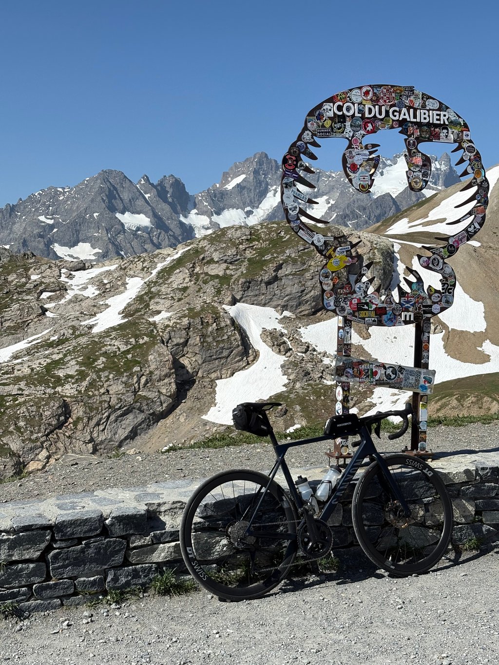
Col du Galibier from Le Clapier is a climb in the region Isère. It is 26.4 mi long and bridges 6601 ft of vertical ascent with an average gradient of 4.7%, resulting in a difficulty score of 1257. The top of the ascent is located at 8668 ft above sea level. Climbfinder users shared 12 reviews of this climb and uploaded 24 photos.
Road names: D 1091, Route de Briançon, D 1091 & D 902
5.0 by GrafstinkerThis is an automatic translation, the original language is: Dutch.From the campsite in Bourg d'Oisans, I rode this climb. Yes, the D1091 is busy (but has an excellent cycle lane along much of the route), but the gradual climb out of the valley is beautiful. Especially from the village of La Grave, you have a great view of the La Meije glacier and the landscape becomes increasingly rewarding towards hard work. The climb is long, but because it also includes a few kilometres with percentages around 3%, and even a few small descents, you can get up in fine... read more
Welcome! Please activate your account if you would like to share something. Look for the verification email in your inbox.
If you want to upload your photos, you need to create an account. It only takes 1 minute and it's completely free.
A unique climb, with a profile very different from the classic Télégraphe route. It starts with a challenging initial stretch, followed by several kilometers that are much easier to ride all the way to the Col du Lautaret.
From Lautaret onward, the climb resumes with gradients that are still fairly consistent but slightly steeper. If you choose to bypass the tunnel and take the historic road, the final kilometer is truly challenging and represents the toughest stretch of the entire ascent.
It’s also an extraordinary climb in terms of scenery. You start by crossing wide valleys and skirting artificial lakes with striking colors, then enter the heart of the Alpine landscape after Lautaret, where the views become simply spectacular.
This climb is absolutely worth doing.
Una salita particolare, con un andamento molto diverso rispetto al versante classico del Télégraphe. Si parte con un primo strappo impegnativo, seguito da molti chilometri decisamente più pedalabili fino al Col du Lautaret.
Dal Lautaret in poi la salita riprende con pendenze ancora abbastanza regolari, ma leggermente più sostenute. Se si sceglie di evitare la galleria e percorrere la strada storica, l'ultimo chilometro è davvero impegnativo e rappresenta il tratto più duro dell'intera ascesa.
Anche dal punto di vista paesaggistico è una salita straordinaria. Si parte attraversando ampie vallate e costeggiando laghi artificiali dai colori sorprendenti, per poi entrare nel cuore dell'ambiente alpino dopo il Lautaret, dove i panorami diventano semplicemente spettacolari.
Una salita che merita assolutamente di essere fatta.
I drove up the climb from Mizoens to Lautaret on my way back from Alpe d'Huez and Sarenne. It was long and hot in the early afternoon, but easy. I found the tunnels pleasant—it was incredibly hot outside, but inside they felt like they had air conditioning. Luckily, I ran into very little traffic. The views from La Grave onward are majestic.
Ho percorso la salita da Mizoens al Lautaret rientrando da Alpe d'Huez e Sarenne. Lunga, calda nel primo pomeriggio ma facile. Le galleries le ho trovate piacevole, fuori faceva un caldo tremendo e lì dentro sembrava di avere il climatizzatore. Per fortuna ho beccato pochissimo traffico. I panorami da La Grave in su sono maestosi.
Legendary climb. Loved it, although the first part (Lautaret) is fairly busy with cars. Sadly had to do it in scorching heat, but still manageable on a bit of a lower effort. Gorgeous climb. Some places have bad tarmac, and the last kilometer is quite steep. Still manageable.
Found this a very enjoyable ride despite people saying it's the worst directions to come from (spoiled!). I departed at 7am on a Sunday and traffic was quiet. The weekend means fewer heavy goods vehicles too. There is still a decent sized cycle lane for most of the ascending route.
I included the RS1091 bike path around the lake, I was confused by the large concrete barriers until I came across a partially collapsed section and many large boulders! I still saw others use it. Officially closed but still frequented. A nice break from the road and avoids climbing the longest tunnel.
I found it easier than Glandon. The gradient to La Grave is fairly benign, so you can find a nice rhythm and take in the increasingly beautiful scenery. A couple of profiles & planners show some mad-looking 20% sections, such as the first tunnel (rampe des commères). They are nothing like, I think, created by GPS data glitches due to signal loss.
Like many I stopped at La Grave for a coffee, snack & to fill the bottles. It's a good stop as you've done three-quarters of the distance, but only half the altitude, so the hardest work is still ahead. I was surprised how bustling the Col de Laurant was bustling, with plenty of places open to eat and drink, tourist info and shops. From there, you can enjoy the final, most spectacular section and feel smug around the people who drove to Lautaret just to ride the final few KM.
Needless to say the climb gets spicier toward the end!
If you plan to stop at the summit for photos and a snack, take a winderbreaker, even in summer. If riding back to Le Bourg-d'Oisans I recommend taking a break immediately back at Lautaret so you can enjoy an uninterrupted and well-earned descent, maybe a few 5/10/20mile PBs too.
As said in many other reviews, the road to Col du Lautaret is very busy. From La Grave the views at National Parc des Ecrins are beautiful with mountain peaks above 4000m. The climb from Lautaret to the summit is spectacular. A clear day would be perfect and you would be able to spot the Mont Blanc as well.
I would give the climb a 5 star from Col du Lautaret to the summit.
From Bourg d'Oisans, a wonderful long climb, not too steep, until you reach Lautaret, from there the slope increases until you reach the top, a special atmosphere for cycling enthusiasts.
Desde Bourg d´Oisans, maravillosa subida larga , no muy pronunciada , hasta que llegas a Lautaret, desde ahí sube la inclinación hasta llegar a la cima, un ambiente especial para los amantes del ciclismo
From the campsite in Bourg d'Oisans, I rode this climb. Yes, the D1091 is busy (but has an excellent cycle lane along much of the route), but the gradual climb out of the valley is beautiful. Especially from the village of La Grave, you have a great view of the La Meije glacier and the landscape becomes increasingly rewarding towards hard work. The climb is long, but because it also includes a few kilometres with percentages around 3%, and even a few small descents, you can get up in fine doses. From the Lauraret to the top of the Galibier, you are treated to the most beautiful the Alps have to offer. Incredible views, hairpin turns, depths and exciting roads. And even these are fine to pedal away. The devil is 'm in the tail here: the last two kilometres from the tunnel do hurt for a while.
A nice alternative to bypass the duller first section of the D1091 from Bourg d'Oisans to Freney d'Oisans is to take the small D220 up after le Clapier, through the villages of Bons, Mont de Lans and then down again via the main road to Le Deux Alpes. Before returning to the main road D1091, you can take the RS1091, a beautiful paved cycling route that passes the Lac du Chambon reservoir south. Then, after Freney d'Oisans, you still end up on the D1091. From there, follow the main route.
Despite the crowds, definitely do it once!
Vanaf de camping in Bourg d'Oisans heb ik deze beklimming gereden. Ja, de D1091 is druk (maar heeft een prima fietsstrook langs een groot deel van de route), maar de geleidelijke klim het dal uit is prachtig. Zeker vanaf het dorp La Grave heb je een prachtig zicht op de Gletscher van La Meije en wordt het landschap steeds meer beloning naar hard werken. De klim is lang, maar omdat er ook een aantal kilometers inzitten met percentages rond de 3%, en zelfs een paar kleine dalingen, kun je prima gedoseerd naar boven. Vanaf de Lauraret naar de top van de Galibier word je getrakteerd op het mooiste wat de Alpen te bieden heeft. Ongelooflijke vergezichten, haarspeldbochten, dieptes en spannende wegen. En ook die zijn prima weg te trappen. Het venijn zit 'm hier in de staart: de laatste twee kilometer vanaf de tunnel doet wel even pijn.
Een leuk alternatief om het saaiere eerste stuk van de D1091 vanaf Bourg d'Oisans tot aan Freney d'Oisans te omzeilen, is door na le Clapier de kleine D220 omhoog te nemen, via de dorpjes Bons, Mont de Lans en dan via de hoofdweg naar Le Deux Alpes weer af te dalen. Voordat je weer op de doorgaande D1091 terugkomt, kun je de RS1091 pakken, een mooie geasfalteerde fietsroute die het stuwmeer Lac du Chambon zuidelijk passeert. Om daarna na Freney d'Oisans alsnog op de D1091 uit te komen. Vanaf daar volg je de hoofdroute.
Ondanks de drukte, zeker een keer doen!
time to laotaret especially the last 8km are tough and take at least 2 large water bottles with you otherwise you won't make it
keer tot aan laotaret zeker de laaste 8km zij pittig en neem minstens 2 grote bidons mee anders kom je niet toe
Made yesterday. Franck Pastor has said it all. Personally, I take a break on the way up to La Grave to fill up my bottles in front of the guide office and on the way back to drink a coke facing the Meije. It's quite long psychologically up to Le Lautaret, even if it's not hard.
Constant traffic. Even on the Galibier in the summer.
Fait hier . Franck Pastor a tout dit. Perso, je fais une pause à l l’aller à La Grave faire les bidons face aux bureau des guides et au retour boire un coca face à la Meije. C'est assez long psychologiquement jusqu au Lautaret même si c est pas dur .
Trafic constant . Y compris au galibier à la belle saison .
The main road to the Col du Lautaret is very busy. Nevertheless, it offers very nice views. It only becomes really beautiful from the Col du Lautaret to the top of the Galibier. You really feel here that you are high up in the mountains. Very nice views, really a must! But that 'recommended' applies mainly to the last part from the Col du Lautaret.
De grote weg naar de Col du Lautaret is erg druk. Desalniettemin levert het erg mooie uitzichten op. Het wordt pas écht mooi vanaf de Col du Lautaret naar de top van de Galibier. Je voelt hier echt dat je enorm hoog in de bergen zit. Heel mooie uitzichten, echt een aanrader! Maar dat 'aanrader' geldt dus wel vooral voor het laatste gedeelte vanaf de Col du Lautaret.
This is a very long climb, which has the disadvantage of suffering from heavy traffic, at least until the Lautaret pass, and of passing through several long tunnels where good lighting is not superfluous. The proposed slopes are not particularly steep either, except at the very beginning (the "Rampe des Commères"), then towards Villard-d'Arêne and the last kilometer before the Galibier pass.
But the landscapes crossed are worth the trip, especially the Infernet gorges and the views on the Meije and the Écrins massif from la Grave.
Très longue montée, qui par rapport à ses variantes des versants Hautes-Alpes et Savoie a le désavantage de souffrir d'une forte circulation, du moins jusqu'au col du Lautaret, et de passer par plusieurs longs tunnels où un bon éclairage n'est pas superflu. Les pentes proposées ne sont pas non plus particulièrement importantes, excepté au tout début (la « Rampe des Commères »), puis vers Villard-d'Arêne et du Lautaret au Galibier, particulièrement le dernier kilomètre.
Mais les paysages traversés valent le déplacement, particulièrement les gorges de l'Infernet et les vues sur la Meije et le massif des Écrins à partir de la Grave.
| 5 mph | 05:18:18 |
| 7 mph | 03:45:21 |
| 9 mph | 02:55:37 |
| 12 mph | 02:11:56 |
This page is better in the app