Tips nearby


| 14 hairpin turns |
| #20 toughest climb of France |
| #31 most elevation gain of France |
| #83 longest climb of Auvergne-Rhône-Alpes |
| #61 average steepest climb of Annecy |
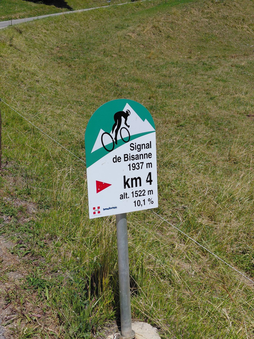
Signal de Bisanne from Ugine / L'Arcy is a climb in the region Annecy. It is 20.2 km long and bridges 1516 m of vertical ascent with an average gradient of 7.5%, resulting in a difficulty score of 1292. The top of the ascent is located at 1934 m above sea level. Climbfinder users shared 3 reviews of this climb and uploaded 7 photos.
Road name: D71, D123, Route du Mont Bisanne
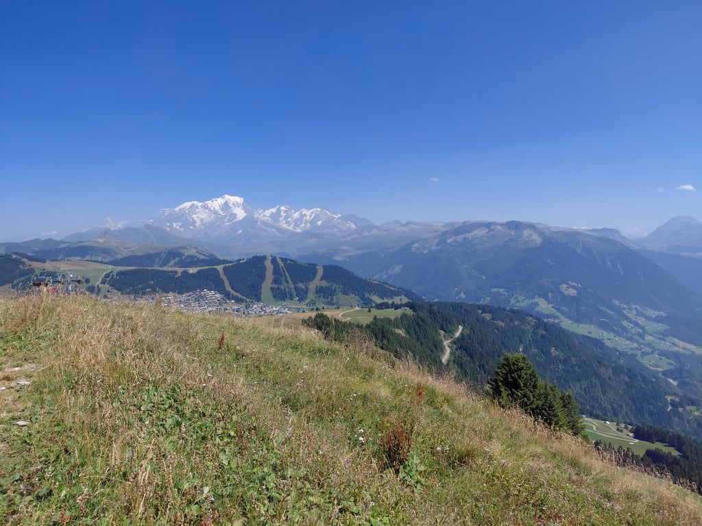
3.0 by YehoSerThis is an automatic translation, the original language is: French.A very difficult climb that will take its toll on your legs and your mind. Very little traffic, especially between the junction with La Forclaz and the resort at 1500 metres. The road isn't always incredible but it goes by without a hitch. The last 4 km are over 10% and the last at 11.3 % so hang on and don't bomb too hard at the start. The last 2 km are closed to traffic (except derogation) which allows you to zigzag a little to limit the gradient. The view from the top is truly i... read more
Welcome! Please activate your account if you would like to share something. Look for the verification email in your inbox.
If you want to upload your photos, you need to create an account. It only takes 1 minute and it's completely free.
Unmarked ascent from Ugine. You get lost on a 16km climb through forest with no visibility, no traffic and no milestones. Forest road with very complicated, if not catastrophic, road conditions. Only the last 4km are pretty, with a clear view of Mont Blanc. The last 2 kilometres are tricky with narrow, pedestrianised track, with a final gradient of over 11%. I would advise against this climb. No pleasure for this climb. Descent inevitably very complicated, not to mention the risk of punctures.
Ascension non indiquée depuis Ugine. On se perd dans 16km de montée en forêt sans visibilité, sans aucune circulation, aucune borne kilomètrique. Route forestière avec état de voie très compliqué, voire catastrophique. Seuls les 4 derniers kilomètres sont jolis avec une vue qui se dégage sur le Mont Blanc. Les 2 derniers kilomètres sont délicats avec voie étroite et piétonnière, avec pente finale à plus de 11%. Je déconseille cette ascension. Aucun plaisir pour cette ascension. Descente forcément très compliquée, sans parler des risques de crevaison.
A very difficult climb that will take its toll on your legs and your mind. Very little traffic, especially between the junction with La Forclaz and the resort at 1500 metres. The road isn't always incredible but it goes by without a hitch. The last 4 km are over 10% and the last at 11.3 % so hang on and don't bomb too hard at the start. The last 2 km are closed to traffic (except derogation) which allows you to zigzag a little to limit the gradient. The view from the top is truly incredible
Montée très difficile qui va faire souffrir vos jambes et votre mental. Très peu de circulation surtout entre le croisement avec la Forclaz et la station à 1500 mètres. La route est pas tjs incroyable mais ca passe sans soucis. Les 4 derniers km sont à plus de 10% et le dernier à 11,3 % alors accrochez vous et ne bombarder pas trop au début. Les 2 derniers km sont interdits à la circulation (hors derogation) ce qui permet d’un peu zigzaguer pour limiter la pente. La vue en haut est vraiment incroyable
In terms of percentages and length a nice col, but on this side only the first and last 5km are worthwhile. From your route the Cohennoz leaves is actually a 'route forestiere' and the road itself is closed. I rode on and if you are a bit adventurous it is quite a nice climb. You are constantly in the forest on a bad road where in some parts the asphalt is washed away until you reach ski resort of Bisanne 1500. From there the road is wide until 2km from the top where you turn onto the ski slope where you only have to watch out for hikers and cyclists. Last 2km are the trickiest with percentages above 10% but with beautiful views of the ski resorts and Mont Blanc. Better from Quiege or Villard.
Qua percentages en lengte een mooie col, maar langs deze kant zijn enkel de eerste en laatste 5km de moeite. Vanaf je route de Cohennoz verlaat is het eigenlijk een 'route forestiere' en de weg is zelf afgesloten. Ik ben doorgereden en als je wat avontuurlijk bent is het best een mooie klim. Je zit constant in het bos op een slechte weg waar op sommige stukken het asfalt weggespoeld is tot je skioord van Bisanne 1500 bereikt. Vanaf daar is het brede weg tot 2km van de top waar je de skipiste opdraait waar je enkel nog moet opletten voor wandelaars en fietsers. Laatste 2km zijn de lastigste met percentages boven de 10% maar met prachtige uitzichten op de skigebieden en de Mont Blanc. Beter vanuit Quiege of Villard.
| 7 km/h | 02:52:54 |
| 11 km/h | 01:50:02 |
| 15 km/h | 01:20:41 |
| 19 km/h | 01:03:42 |
This page is better in the app