Tips nearby


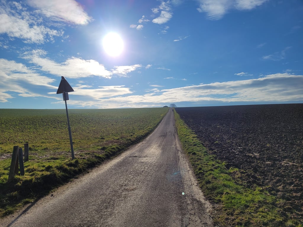
Korenweg is a climb in the region South Limburg. It is 0.9 km long and bridges 52 m of vertical ascent with an average gradient of 5.7%, resulting in a difficulty score of 41. The top of the ascent is located at 197 m above sea level. Climbfinder users shared 13 reviews of this climb and uploaded 8 photos.
Road name: Korenweg
by Henk.This is an automatic translation, the original language is: Dutch.This road runs from the valley approximately west-east. With the prevailing wind in the Netherlands you cycle when you go down against the wind and when you go up with the wind in your back. Tip: To have the wind in your back when cycling down, it is best to cycle backwards.... read more

Welcome! Please activate your account if you would like to share something. Look for the verification email in your inbox.
If you want to upload your photos, you need to create an account. It only takes 1 minute and it's completely free.
A steep two-stage climb through open arable land that stings mentally as well as physically, with a short descent halfway through and a final vicious final touch on narrow, moderate road surface in an otherwise beautiful, peaceful setting.
Een steile tweetrapsklim door open akkerland die mentaal én fysiek prikt, met een korte afdaling halverwege en een laatste venijnige uitsmijter op smal, matig wegdek in een verder fraaie, rustige omgeving.
Tricky thing: you have a view of the hugely steep first section as you turn up. But after this part, you are not there yet - hidden among the trees is a final steep section - spicy.
Lastig ding: je hebt bij het opdraaien uitzicht over het enorm steile eerste deel. Maar na dit deel ben je er nog niet - tussen de bomen verscholen zit nog een laatste steile stuk - pittig.
Beautiful and tough climb in beautiful surroundings. Road can be dirty though. And you are also unlucky if you take the descent from Colmont, but have to brake for traffic on the Vrakelbergerweg. Then you can whistle for a PR.
Mooie en pittige klim in een prachtige omgeving. Weg kan wel viezig zijn. En je hebt ook dikke pech als je vanuit Colmont de afdaling neemt, maar je moet remmen voor verkeer op de Vrakelbergerweg. Dan kun je naar een PR wel fluiten.
One the tough climbs on either side of the Vrakelbergweg. This one is a two-stage climb. You go 250 metres from the Vrakelbergweg straight up steeply. Then it flattens out and you even descend for a bit. From 650 metres up to the top it then goes up again. Both the first and the second part have sections in double figures.
Eén de pittige klimmetjes aan weerszijden van de Vrakelbergweg. Deze is een tweetraps klim. Je gaat vanaf de Vrakelbergweg 250 meter gelijk flink omhoog. Daarna vlakt het af en daal je zelfs een stukje. Vanaf 650 meter gaat tot het de top dan weer omhoog. Zowel in het eerste als tweede deel lopen stukken v.w.b. stijgingspercentage in de dubbele cijfers.
You feel this one twice. In fact, you get a short downhill after the first section, after which you get straight back to work for lap 2. The road is narrow and the road surface is not fantastic.
Deze voel je twee keer. Je krijgt namelijk na het eerste deel een korte afdaling cadeau, waarna je direct nog eens aan de slag mag voor ronde 2. De weg is smal en het wegdek is niet fantastisch.
Climb similar to the parallel ridgeline road to the Eckelrade plateau. Beautiful surroundings!
Klim vergelijkbaar met de parallel gelegen ribbelheideweg naar het plateau van Elkenrade. Prachtige omgeving!
The first part is the most difficult, going straight up a hill through the fields. For the second hill, you can take a lot of momentum from a small descent.
Although it is a very small road, I still saw cars.
Der erste Teil ist der schwierigste es geht schnurgerade auf einen Hügel durch die Felder. Für den zweiten Hügel kann man viel Schwung aus einer kleinen Abfahrt mitnehmen.
Obwohl es sich um eine sehr kleine Straße handelt, habe ich trotzdem Autos gesehen.
I made a big mistake on the Korenweg. I had not thought of it as a real climb. In fact, when descending from Colmont and crossing the Vrakelbergerweg (just be careful) it doesn't look like a climb at all. You see the road running straight ahead between the fields. With a full headwind, I struggled up and it became quite steep. And then, after a short descent, another tough kink. Not an insanely beautiful climb, but one on which you can hurt yourself or others.
Ik verkeek me flink op de Korenweg. Ik had het niet in mijn hoofd alszijnde een echte klim. Bij het afdalen vanaf Colmont en het oversteken van de Vrakelbergerweg (even goed uitkijken) lijkt het namelijk ook helemaal geen beklimming. Je ziet de weg kaarsrecht vooruitlopen tussen de akkers. Met volle wind tegen worstelde ik me omhoog en werd het toch flink steil. En toen, na een korte afdaling nog zo pittige knik. Geen waanzinnig mooie klim, maar wel één waarop je jezelf of anderen pijn kunt doen.
This climb is very clear and in parts also very steep. This can cause some anxiety in the first few metres. The best part about this hill is the push in the descent halfway and then try to sprint uphill as far as possible. Bonus points because you are riding through the fields, which gives an extra dimension to the climb.
Deze klim is zeer overzichtelijk en op stukken ook behoorlijk steil. Dat kan wat angst inboezemen in de eerste meters. Het allerleukste aan deze heuvel is het aanzetten in de afdaling halverwege en daarna zo ver mogelijk bergop proberen te sprinten. Bonuspunten omdat je dwars door de maaivelden aan het rijden bent, wat een extra dimensie geeft aan de klim.
This climb is mentally a bit of a swallow (and thus a challenge) when you see the dead straight road against the slope, and then the tree "on top" only halfway the climb. The first part is quite steep. The second part is also steep but then you can use the descent for a run. At the edge of the forest it is over with the percentages.
Deze klim is mentaal even slikken (en dus een uitdaging) als je de kaarsrechte weg zo tegen de helling ziet liggen, en dan staat de boom "bovenop" nog maar halverwege de klim. Eerste deel is flink steil. het tweede stuk ook maar dan kan je met de afdaling er voor iig nog een aanloop nemen. Bij de bosrand is het wel over met de percentages.
Like many climbs around the Vrakelbergerweg quite steep. It starts immediately well, then on the piece of descent 'm just put on the big plate and see how far you come after that.
Zoals zo vele klimmen rondom de Vrakelbergerweg vrij steile stukken. Het begint meteen goed, dan op het stukje afdaling 'm even op de grote plaat leggen en kijken hoe ver je daarna komt.
This road runs from the valley approximately west-east. With the prevailing wind in the Netherlands you cycle when you go down against the wind and when you go up with the wind in your back.
Tip: To have the wind in your back when cycling down, it is best to cycle backwards.
Deze weg loopt vanuit het dal ongeveer west-oost. Bij de overwegende westen wind in Nederland fiets je dus als je naar beneden gaat tegen de wind in en dus wanneer je naar boven gaat met de wind in de rug.
Tip: Om bij het naar beneden fietsen weer de wind in de rug te hebben kan je het beste achteruit fietsen.
| 7 km/h | 00:07:51 |
| 11 km/h | 00:05:00 |
| 15 km/h | 00:03:40 |
| 19 km/h | 00:02:53 |
This page is better in the app