Tips nearby


| Beautiful scenery |
| Hidden gem |
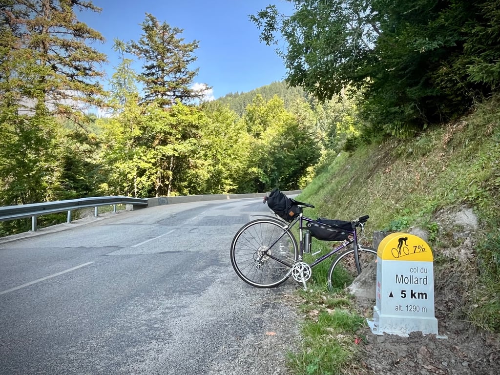
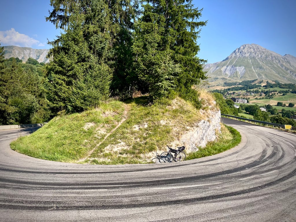
| 18 hairpin turns |
| #30 toughest climb of La Maurienne |
| #79 most elevation gain of Savoie |
| #75 longest climb of Savoie |
| #72 average steepest climb of La Maurienne |
Col du Mollard from Saint Jean de Maurienne is a climb in the region La Maurienne. It is 15.7 km long and bridges 1046 m of vertical ascent with an average gradient of 6.6%, resulting in a difficulty score of 761. The top of the ascent is located at 1632 m above sea level. Climbfinder users shared 8 reviews of this climb and uploaded 21 photos.
Road names: D 110 & Route du Mollard
3.0 by Herve2023This is an automatic translation, the original language is: French.A quick comment on the road: most of the surface is brand new, especially in the upper section. So riding on it is very pleasant. A very pleasant descent, particularly with its many bends and the passage through the gorges.... read more
Welcome! Please activate your account if you would like to share something. Look for the verification email in your inbox.
If you want to upload your photos, you need to create an account. It only takes 1 minute and it's completely free.
A quick comment on the road: most of the surface is brand new, especially in the upper section. So riding on it is very pleasant. A very pleasant descent, particularly with its many bends and the passage through the gorges.
Petit commentaire sur la route : la majeure partie du revêtement est tout neuf, notamment dans la partie supérieure. Rouler dessus est donc très agréable. Descente très plaisante, en particulier avec ses nombreux virage et le passage à travers les gorges.
Spontaneously, his name is not particularly attractive!
For me, there was no history or memory attached to it, and yet Pierre Roland twice led the way here.
But on this pass, you're just passing through.
So I decided to go up to La Toussuire instead.
And then, on the way up, the "Col du Mollard" markers caught my eye!
I don't regret it. This pass was a real pleasant surprise.
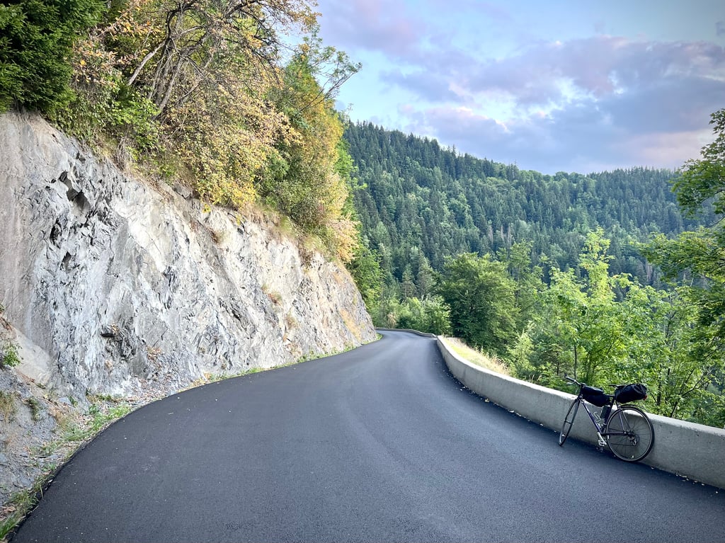
The first few kilometres were a bit boring. But the last 6 are quite pleasant.
The surface has been redone on the critical sections.
The gradients are serious but never diabolical.
The bends are prodigious and magical. They were undoubtedly designed by a cyclist who is an expert in exciting descents!
In fact, the bends on this pass are preciously numbered in the direction of the descent.
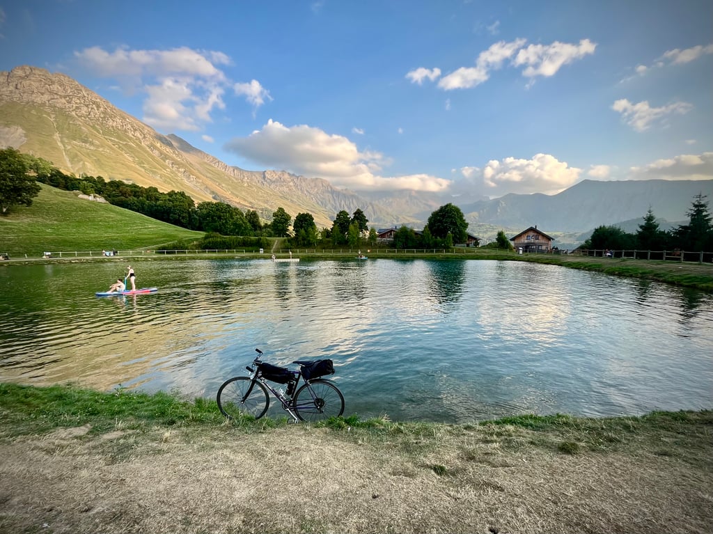
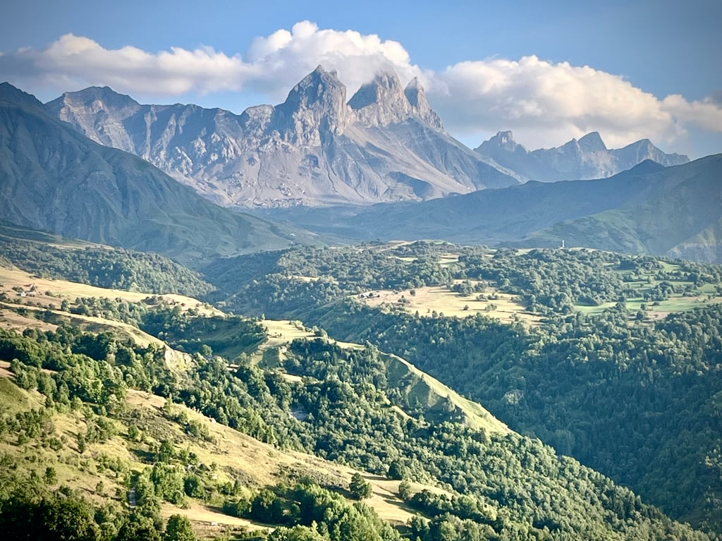
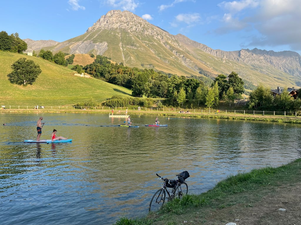
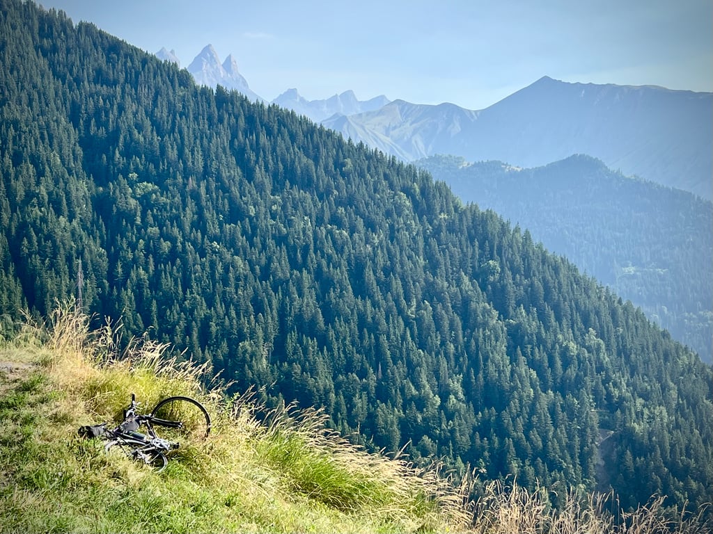
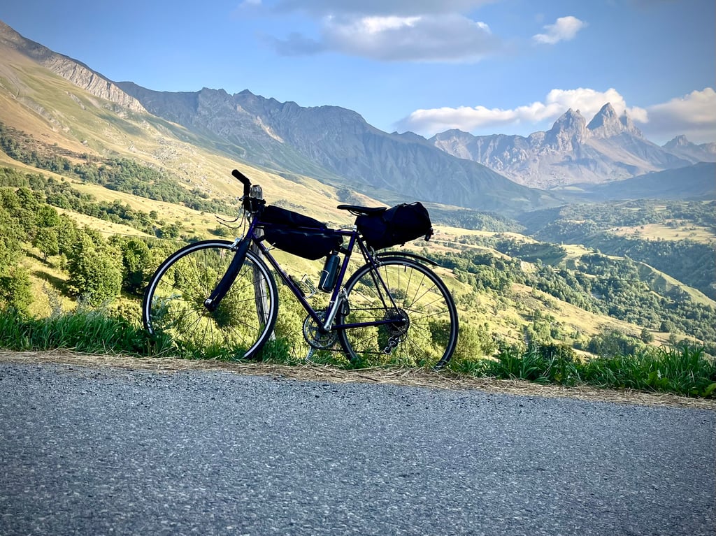
Up there, the Aiguilles d'Arves are very elegant. The little lake nestling in the mountains is really cute. The village makes you want to spend a few days there.
This pass isn't absolutely stunning, but it's beautiful all the same.
And the descent is a real treat.
Spontanément, son nom n’est pas particulièrement seyant !
Pour moi, il n’était rattaché à aucune histoire, à aucun souvenir et pourtant Pierre Roland est passé deux fois en tête ici.
Mais voilà, sur ce col, on ne fait que passer.
Bref, j’avais décidé de monter plutôt à La Toussuire.
Et puis, sur le chemin, les bornes « Col du Mollard » m’ont happé !
Je ne le regrette pas. Ce col a été une vraie bonne surprise.
On s’ennuie un peu dans les premiers kilomètres. Mais, les 6 derniers sont plutôt bien agréables.
Le revêtement a été refait sur les parties critiques.
Les pourcentages sont sérieux, mais jamais diaboliques.
Les virages sont prodigieux et magiques. Assurément tracés par un cycliste expert en descentes excitantes !
D’ailleurs, les virages de ce col sont précieusement numérotés dans le sens de la descente.
Là-haut, les aiguilles d’Arves sont très élégantes. Le petit plan d’eau lové dans les montagnes est très mignon. Le village donne carrément envie d’y passer quelques jours.
Ce col n’est pas absolument renversant, mais il est tout de même très beau.
Et sa descente est un petit régal.
I had my bike serviced (new pads) in the morning , so I chose this ride for the afternoon. A great climb from SJM, little traffic and scenic views.
For me, this is the nicest side of the Col and the least known because it has never been part of the Tour or the Dauphiné, just the Tour de l'Avenir. The road is extremely dangerous on the descent because of the surface, which is unworthy of an access road to one of the 5 majors of the French Alps, since the road leads to the Cx de Fer via Albiez, which is 35 kilometres of hump. But on the climb, it's a bit of a treat in my case, as I'm staying in Albiez as a break from the Trilogie de Maurienne. A quiet start with a long 3 km false flat, then you arrive at the hydroelectric plant and the climb really starts'gently at first with slopes that are familiar to me from Auvergne, 4-5 per cent, then when you reach the car park the slope steepens into the Arve gorges, from Le Gevoudaz onwards it's non-stop;It's a long climb of between 8 and 12 kilometres, but for me it's almost a pleasure because I'm light enough for it, but for a Dutchman or someone from the plains it must be a real ordeal because even for me it's unnatural to climb long passes at 8 kilometres. Small flat spot before Albiez le Vieux then two horrible km with a slope and the sun beating down if it's hot inside. Fountain and small area to rest at the top.
Pour moi le versant le plus sympa du Col et le plus méconnu car jamais passé par le Tour ou le Dauphiné, juste le Tour de l'Avenir. la route est hyper dangereuse en descente du fait du revêtement indigne d'une route d'accès à un des 5 majeurs des Alpes Française, puisque la route mène à la Cx de Fer via Albiez soit 35 bornes de bosse. Mais en montée, c'est un petit plaisir fait dans mon cas en déblocage de la Trilogie de Maurienne étant logé à Albiez. début tranquille en long faux plat de 3 km puis on arrive à l'usine hydroélectrique et la montée débute vraiment d'abord doucement avec des pentes familières pour moi auvergnat, 4-5 pourcent puis arrivé au parking la pente se cabre dans les gorges de l'Arve, à partir du Gevoudaz ça n'arrête plus, de longs km entre 8 et 12% à grimper, mais pour moi presque un plaisir en en chiant car j'ai le gabarit léger pour, mais pour un néerlandais ou un mec de la plaine ça doit être un beau supplice tant même pour moi c'est peu naturel les longs cols à 8%. Petit replat avant Albiez le Vieux puis deux km horrible avec de la pente et le soleil qui tape en cas de chaleur dedans. Fontaine et petite aire pour se poser en haut.
One of the three climbing routes to the Col du Mollard starts from St.Jean de Maurienne that you cycle out of via the main route to Croix de Fer, which you soon leave for the secondary D110.
There, the start is indicated by the white-yellow info posts that will keep you informed for 16 km. (distance to summit/altitude/%volgende km.). Initially fairly straight slightly ascending road that crosses the Arvan mountain river several times.
From En Bas de Maisons ( CF starting point), the unnumbered hairpin bends start up the forested rock face (shade) briskly uphill, occasionally through villages with a few houses and panoramas's on snow-covered mountain peaks. A little less climbing when cycling into Albiez-le-Vieux, where you also join the route from Villargondran, for the last two tough km. to the summit.
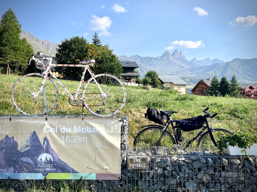
At highest point is course bike with polka-dot shrub vein, there is a water source, catering (June still closed though) and
views where the Aiguilles d'Arves (French "Tre Cime") in particular stood out.
The tarmac is of varying quality and there is usually hardly any traffic.
In June 2023, it was exceptionally slightly busier as the Croix de Fer was closed for a long time due to roadworks and all traffic was diverted via this climb. An unplanned introduction for many cyclists .
For me, the climb was planned and highly recommended !
Eén van de drie klimroutes naar de Col du Mollard vertrekt uit St.Jean de Maurienne dat je uit fietst via de grote route naar Croix de Fer, dewelke je snel verlaat voor de secundaire D110.
Daar wordt de start aangegeven door de witgele infopaaltjes die je 16 km. lang op de hoogte zullen houden. (afstand tot top/hoogte/%volgende km.). Aanvankelijk vrij rechte licht oplopende weg die enkele keren de Arvan bergrivier overgaat.
Vanaf En Bas de Maisons ( CF startpunt) beginnen de ongenummerde haarspeldbochten de beboste rotswand (schaduw) stevig naar omhoog, af en toe door dorpjes met enkele huizen en panorama's op besneeuwde bergpieken. Even wat minder klimmen bij het binnen fietsen van Albiez-le-Vieux, waar je ook de route vanuit Villargondran vervoegd, voor de laatste twee pittige km. tot de top.
Op hoogste punt staat koersfiets met bolletjestruikader, is er een waterbron, horeca (juni nog wel gesloten) en
uitzicht waar vooral de Aiguilles d'Arves (Franse "Tre Cime") in het oog sprongen.
Het asfalt is van wisselende kwaliteit en er is meestal amper verkeer.
In Juni 2023 was het uitzonderlijk iets drukker doordat de Croix de Fer lang afgesloten was door wegwerkzaamheden en alle verkeer werd omgeleid via deze klim. Voor veel fietsers een ongeplande kennismaking .
Bij mij was de klim voorzien en een absolute aanrader !
Made during the Maurienne laces, long straight line in false flat going up at the beginning of ST Jean de Maurienne until the starting point just after the crossing of the bridge which spans the Arvan.
The first part is parallel to the road to the Col de la Croix de Fer, which can be seen by looking up.
The Col du Mollard on this side is long and steep, the tarmac at the time I climbed it was not very nice.
Fait pendant les lacets Mauriennais, longue ligne droite en faux plat montant au départ de ST Jean de Maurienne jusqu'au point de départ juste après la traversé du pont qui enjambe L'Arvan.
Parallèle sur la première partie à la route du col de la Croix de Fer que l'on peu apercevoir en levant la tête .
Le col du Mollard par ce versant est long et pentu, le bitume à l'époque où je suis monté n'était pas folichon.
I can confirm that the tarmac hasn't been resurfaced, the organisers of the Trilogie de Maurienne had to neutralise the descent at our request because it's worthy of a goat track in the Cantal region in terms of the state of the road, which is a shame because it's a nice pass;I think they'll redo the road the day Tour goes uphill, because downhill they've never redone it, despite the fact that Ludo Turpin left a femur in it in 2006.
Je te confirme le goudron n'a pas été refait, l'orga de la Trilogie de Maurienne a du neutraliser la descente à notre demande car c'est digne d'un chemin de chèvre dans le Cantal niveau état de la route, dommage car c'est un col sympa, je pense qu'il referont la route, le jour où Tour passera en montée, car en descente il ne l'ont jamais refaite, malgré le fait que Ludo Turpin y est laissé un fémur en 2006 dedans.
I climbed it only once, in 1997 during my BRA (Brevet de Randonnée Alpine), before attacking the Croix de Fer. I have the memory of a pleasant climb, exposed to the sun, quite difficult, but it was partly due to the fact that I already had the Lautaret and the Galibier in my legs that day...
Montée que j'ai gravie une seule fois, en 1997 lors de mon BRA (Brevet de Randonnée Alpine), avant d'attaquer la Croix de Fer. J'ai le souvenir d'une montée au paysage agréable, exposée au soleil, assez difficile, mais cela était dû en partie au fait que j'avais déjà le Lautaret et le Galibier dans les jambes ce jour-là…
| 7 km/h | 02:14:55 |
| 11 km/h | 01:25:51 |
| 15 km/h | 01:02:58 |
| 19 km/h | 00:49:42 |
This page is better in the app