Tips nearby


| 4 hairpin turns |
| #44 toughest climb of Occitania |
| #96 most elevation gain of Occitania |
| #40 longest climb of Hautes-Pyrénées |
| #79 average steepest climb of Hautes-Pyrénées |
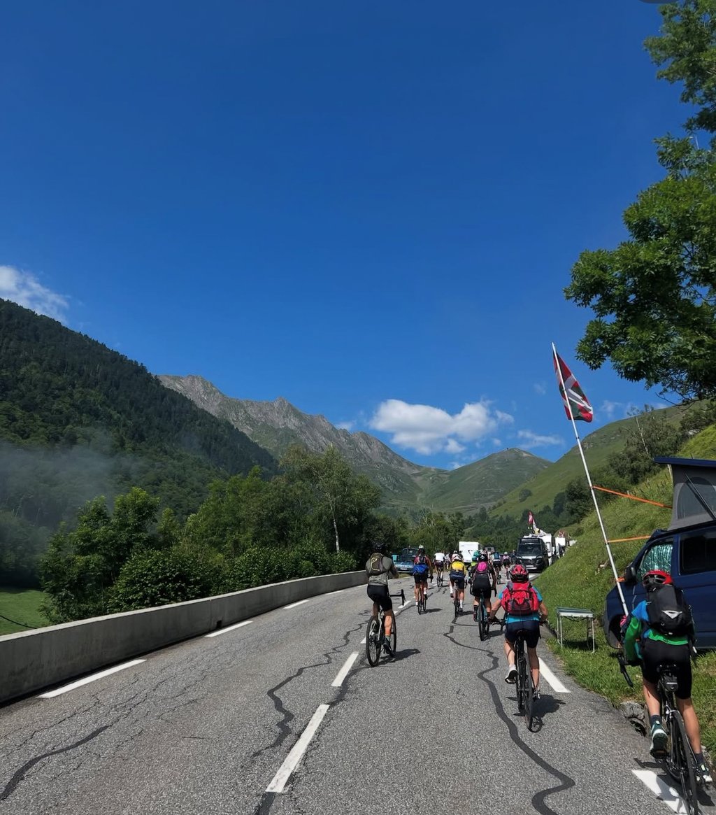
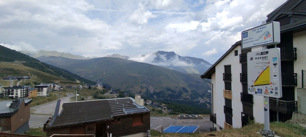
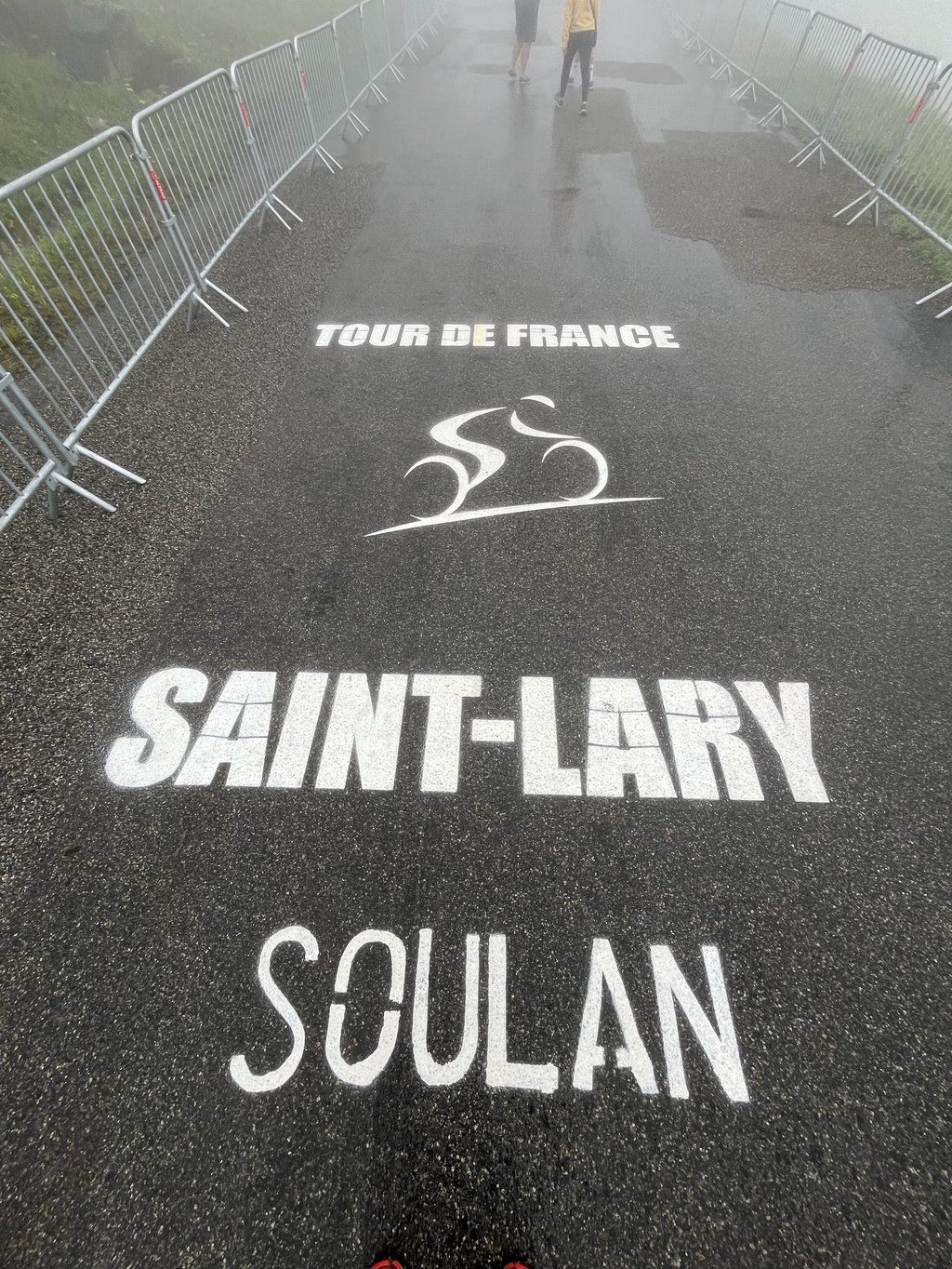
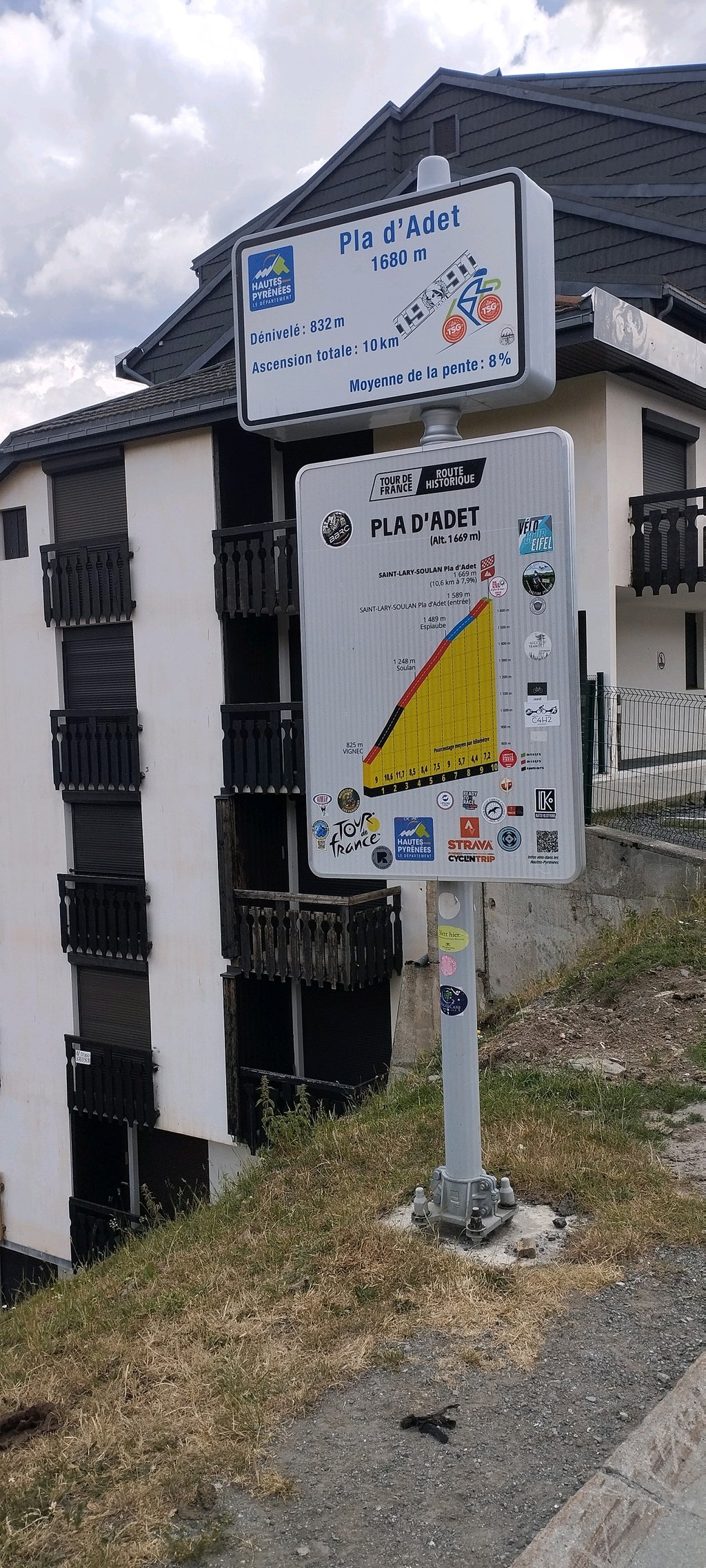
Pla d'Adet from Saint Lary Soulan is a climb in the region Hautes-Pyrénées. It is 6.2 mi long and bridges 2795 ft of vertical ascent with an average gradient of 8.5%, resulting in a difficulty score of 783. The top of the ascent is located at 5463 ft above sea level. Climbfinder users shared 16 reviews of this climb and uploaded 21 photos.
Road name: D123
3.0 by christineThis is an automatic translation, the original language is: English.this isnt that great, just a ski resort and nothing was open today (14/9/24). even the views down the valley are blocked by apartments. the climb up had moderate traffic. ride col de portet once you reach the junction: much prettier!... read more
Welcome! Please activate your account if you would like to share something. Look for the verification email in your inbox.
If you want to upload your photos, you need to create an account. It only takes 1 minute and it's completely free.
This climb is shorter than the one at Portet, but the first 8 km are the same, with gradients of over 10%. There are a few restaurants and cafés open in the summer where you can enjoy a well-deserved drink!
Ascension plus courte que celle du Portet mais qui partage les mêmes premiers 8km avec des pentes à +10%. Quelques restaurants et cafés ouvert en été pour prendre un verre bien mérité !
After 7 km, it’s better to keep going first to complete the Col du Portet, and then finish this climb during the descent. It pales in comparison to the Portet. The asphalt has deep ruts, so it’s best to ride on the sides.
Het is beter om na 7km eerst verder te gaan om Col du Portet te volbrengen, en tijdens de afdaling dan deze klim af te maken. Hij verbleekt tov. de Portet. Het asfalt bevat diepe gleuven, rij best aan de zijkanten.
A beautiful climb with a summit finish during the Tour de France stage ⛰️
Une très belle montée avec une arrivée au sommet lors de l’étape du Tour de France ⛰️
It's tough, the view from the top doesn't really reward the effort, it's nice when the tour passes by and there are people and atmosphere, but not much more, that said it's not bad to say you've done it once you're at the top.
C’est dur, la vue au sommet ne récompense pas vraiment les efforts, c’est sympa lorsque le tour y passe et qu’il y a du monde et de l’ambiance, mais pas bien plus, ceci dit c’est pas mal de se dire qu’on l’a fait une fois en haut
It's a climb you have to have to say you've done it. But otherwise the summit isn't very pretty, just a ski resort and nothing is open. I'd advise you to do the Col de Portet, which is just next door and has a magnificent view from the summit.
Une montée à avoir pour dire qu’on l'a fait. Mais sinon le sommet n'est pas très jolie, juste une station de ski et rien n’est ouvert. Je vous conseille de faire le col de Portet qui est juste à côté et dont la vue au sommet est magnifique
Taken before the riders on 13 July as the Tour passed by. Apart from the heat, it was a lot of fun!
Faite avant les coureurs le 13 juillet dernier lors du passage du Tour. Hormis la chaleur, que du plaisir !
Did this one in the morning and rode almost the entire climb in the sun. You might have to take this into account in summer. There are plenty of water points on this climb though so that's not a problem. In my opinion, the hardest part is in the beginning, up to 4 km before the top it is quite steep, I am not really a climbing type (+85kg) so you do feel that, those steep pentes. Nice though with the memorials to Poupou.
Deze in de voormiddag gedaan en bijna de hele klim in de zon gereden. Hier moet je in de zomer misschien wel rekening mee houden. Er zijn wel veel waterpunten op deze klim dus dat is geen probleem. Hier zit het lastigste naar mijn mening in het begin, tot een 4 km voor de top is het toch vrij steil, ik ben niet echt een klimtype (+85kg) dus dat voel je wel, die steile pentes. Wel leuk met de herdenkingsplaatsen aan Poupou.
A must-do because of its difficulty. The view of St Lary is magnificent. At the foot, you think there's no bend and it's on a mountainside, but once you're inside, it's real!
A faire de part sa difficulté. La vue sur St Lary est magnifique. Au pied, on se dit que c'est sans virage et à flanc de montagne, une fois dedans, c'est vrai!!
I had not planned to do this climb, but I saw at the junction with the col de Portet, that it was only a few km to the summit of the Pla d'Adet. The views are not very thunderous after the turn-off, and the climb ends in a deserted ski village. Here I got some water and then descended to finish the Col de Portet. The climb has been used several times in the Tour de France, though. This made it worth ticking off this col, although the views from Pla d'Adet were not impressive. For great views, you should opt for the Col de Portet at the turn-off!
Ik was niet van plan om deze beklimming te doen, maar ik zag bij de afsplitsing met de col de Portet, dat het nog maar een aantal km was naar de top van de Pla d'Adet. Het uitzicht is na de afsplitsing niet heel denderend, en de klim eindigt in een verlaten skidorpje. Hier heb ik wat water gehaald en ben ik vervolgens afgedaald om de Col de Portet af te maken. Wel is de klim een aantal keer gebruikt in de Tour de France. Dit maakte het waard om deze col af te vinken, al waren de uitzichten vanaf Pla d'Adet niet indrukwekkend. Voor mooie uitzichten moet je bij de afsplitsing voor de Col de Portet kiezen!
The first part is definitely recommended, after the junction with the Portet it is a little less but not bad at all. Quite tough but nevertheless happy to have done it!
Het eerste deel is zeker een aanrader, na de splitsing met de Portet is het iets minder maar daarom zeker niet slecht. Best wel pittig maar desondanks toch blij deze gedaan te hebben!
In 2008, I was in the mountains for the first time on a road bike and lived up in the ski village of Pla D'Adet. In the 3 weeks I rode the route 1x by mountain bike and 2x by road bike, it is a real killer climb. The first 7km are just about survival for the fit average rider (like me).
Now, in 2022 and at the age of 58, I have ridden the climb again. It hasn't changed of course and I did it without dismounting on a heavy gravel bike in bright sunshine. Fierce !
If you are looking for a real challenge, you should give this climb a try!
2008 war ich das erste Mal im Gebirge mit dem Rennrad und wohnte oben im Skidorf des Pla D'Adet. In den 3 Wochen bin ich die Strecke 1x mit dem Mountainbike und 2x mit dem Rennrad gefahren, es ist eine echte Killersteigung. Die ersten 7km geht es für den fitten Durchschnittsfahrer (wie mich) nur ums Überleben.
Jetzt, 2022 und mit 58 Jahren bin ich die Steigung wieder gefahren. Sie hat sich natürlich nicht verändert und ich habe sie ohne Absteigen mit einem schweren Gravelbike in strahlender Sonne geschafft. Heftig !
Wer eine echte Herausforderung sucht, sollte sich diese Auffährt geben !
Cycled up the beautiful climb to the earthly ugly concrete ski resort above St. Lary Soulan, already 10 X arrival place in the Tour.
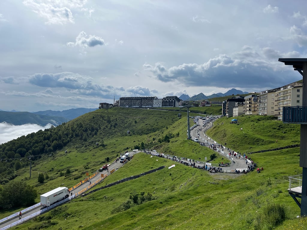
At the start you can see from the roundabout in Vignec the bunker-like flats of the summit but also the Z-shaped starting route hanging against the rocks like a gutter. Right away, there are also the cycling information signs (distance to summit/altitude/slope of the next kilometer) which immediately announce a very steep start of +10%. The departure town and the Aure river quickly sink under you, providing you with beautiful panoramas. The mountain village of Soulan, with its speed bumps and fountain (fresh water), is a relief, but afterwards, the climb is double again. In a big curve to the left in Espiaube there is a short downhill section next to the exit to the Col de Portet to the overhanging ridge and then a fairly straight road a bit less steep to reach the finish. It's a summery village with empty buildings and parking lots, closed restaurants and a view on the slopes covered with ski lifts.
Not to be underestimated, this is a nice climb to do out of historical interest, although the top is a bit disappointing.
De prachtige klim naar het aards lelijke betonnen skioord boven St.Lary Soulan, reeds 10 X aankomstplaats in de Tour, omhoog gefietst.
Bij de start zie je vanop de rotonde in Vignec de bunkerachtige flats van de top maar ook de Z-vormige aanvangsroute als dakgoot tegen de rotsen hangen. Meteen zijn er ook de fietsinfobordjes (afstand tot top/hoogte/hellingsgraad komende kilometer) die meteen een zwaar steil beginstuk van + 10% aankondigen. Vertrekstadje en de Aure rivier zakt snel onder je weg en dit levert prachtige panorama's op. Bergdorp Soulan halfweg,met verkeersdrempels en fontein (fris water), zorgt even voor verademing doch nadien zijn er weer dubbele klimcijfers. In een grote bocht naar links in Espiaube is er naast de afslag naar de Col de Portet even een strook bergaf naar de overliggende heuvelkam om nadien langs een vrij rechte weg iets minder steil het eindpunt binnen te fietsen. Een zomers uitgestorven skioord met lege gebouwen en parkings, gesloten horecazaken en uitzicht op hellingen bezaait met skiliften.
Niet te onderschatten mooie klim die je uit Tour historisch belang zeker moet doen alhoewel de top wat tegenvalt.
Yup, this is a must.
Up with the bike and down with the cable car.
And then contemplate how mountain goat Van Impe won the last Flemish Tour.
Yup, dit is een aanrader.
Met de fiets naar boven en met de kabelbaan naar beneden.
En dan mijmeren hoe berggeit Van Impe de laatste Vlaamse tour won.
A real killer! If you pay attention in the valley, you'll see the road is already frighteningly steep up along the rocks. Also the buildings on the top are almost the entire climb visible. The first 7 kilometres are purely a matter of survival, with a constant 10 per cent gradient (peaks up to 13) and no real shade anywhere. In 2014 I toiled in the blazing sun at 35 degrees. Only in the village of Soulan does it get a little easier and trees appear. Just before the forest you can turn right to the Col de Portet, a challenging mountain bike climb. Once arrived in the ski village, there is unfortunately no breathtaking view, or you'll have to maneuver along or in the buildings. One of the tougher cols of the Pyrenees!
Een echte killer! Wie in het dal goed oplet, ziet de weg al angstaanjagend steil langs de rotsen omhooglopen. Ook de gebouwen op de top zijn vrijwel de gehele klim zichtbaar. De eerste 7 kilometer is het puur een kwestie van overleven, met voortdurend 10 procent stijging (pieken tot 13) en nergens echt schaduw. In 2014 zwoegde ik met 35 graden in de brandende zon. Pas in het dorpje Soulan wordt het wat makkelijker en verschijnen er bomen. Vlak voor het bos kun je rechts afslaan naar de Col de Portet, een uitdagende mountainbikeklim. Eenmaal in het skidorp aangekomen, ontvouwt er zich helaas geen adembenemend uitzicht, of je zult je langs of in de gebouwen moeten manoeuvreren. Een van de zwaardere cols van de Pyreneeën!
| 5 mph | 01:15:10 |
| 7 mph | 00:53:13 |
| 9 mph | 00:41:28 |
| 12 mph | 00:31:09 |
This page is better in the app