Mont du Chat from Yenne is a climb in the region Savoie. It is 11 mi long and bridges 4154 ft of vertical ascent with an average gradient of 7.2%, resulting in a difficulty score of 1161. The top of the ascent is located at 4875 ft above sea level. Climbfinder users shared 8 reviews of this climb and uploaded 6 photos.
This is an automatic translation, the original language is: French.
Climbing from St Paul de Yenne. Fearsome climb, the last 8 km are terrible! Without a break, the counter showed between 11 and 14%! I found this side much more difficult than the climb from Lac du Bourget, done this spring. To be done for the challenge!
...read more
Photos (6)
Welcome! Please activate your account if you would like to share something. Look for the verification email in your inbox.
This is an automatic translation, the original language is: French.
Show original
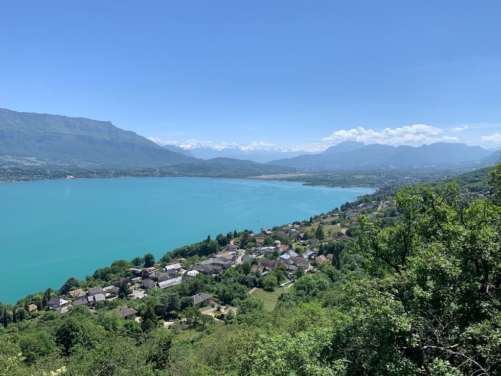
Very nice climb with the foot relatively easy. It gets tougher for the last few kilometres where the percentage doesn't drop below 10-11%. The view of Lac du Bourget from the summit is simply magnificent.
Très belle ascension avec le pied relativement facil. Cela se durcit pour les derniers kilomètres ou le pourcentage ne descend pas sous les 10-11%. La vue, au sommet sur le lac du Bourget est simplement magnifique.
This is an automatic translation, the original language is: French.
Show original
I climbed on a very cloudy day, so you couldn't see anything at the top, but at least I was alone for the whole climb and no car overtook me in the last 10 km. The start is fairly straightforward but you mustn't set off too quickly. There's a short descent before the last 8 kilometres, which are terrible, so you have to make the most of it. Then it climbs like a steamroller all the way to the summit, with a mini flat spot in the middle. The milestones are very useful and help you to organise your pace. The last kilometre is fairly straightforward and you can speed up if you still have the energy. I have the KOM for the climb, but only 125 people have done it. In fact, the real climb is on the Chambuet road, which you reach after just 1km. From there I have the 2nd best time.
Ascension montée lors d'un jour très nuageux, on ne voyait rien au sommet mais au moins j'ai pu être seul durant toute l'ascension et aucune voiture ne m'a dépassé dans les 10 derniers kms. Le départ est assez simple mais il ne faut pas partir trop vite. Il y a une petite descente avant les 8 derniers kilomètres qui sont terribles, il faut en profiter. Ensuite ça monte comme une rouleau compresseur jusqu'au sommet et avec un mini replat au milieu. Les bornes sont très utiles et permettent de bien organiser son rythme. Le dernier km est assez simple et on peut accélérer si on a encore le jus. J'ai le KOM de la montée mais seulement 125 personnes l'ont faites. En fait la véritable ascension est sur la route de Chambuet que l'on rejoint après seulement 1km. A partir de là j'ai le 2e meilleur temps.
This is an automatic translation, the original language is: French.
Show original
The first few km serve as a warm-up (or a refresher if you've done the east side first...).
The last 9km are steep, almost always at 10-11%, and passages at 12%. No respite. The penultimate km at almost 12% is severe, especially if this is your 2nd Hors Catégorie of the day.
If you stay in zone 3, on the train, you can set a reasonable pace to avoid getting into the red.
Not unhappy that this climb is taking place in the shade in the middle of summer...
A quiet road with a decent surface, but be careful on the descent.
Les premiers km servent de mise en jambe (ou remise en jambe si vous avez d'abord fait le côté Est...).
Les 9 derniers km sont abrupts, presque toujours à 10-11%, et des passages à 12%. Aucun répit. L'avant-dernier km à presque 12% est sévère, surtout si on en est à son 2ème Hors Catégorie de la journée.
Si on reste en zone 3, au train, on peut prendre un rythme raisonnable pour éviter de se mettre dans le rouge.
Pas mécontent que cette ascension se déroule à l'ombre en plein été...
Route calme et revêtement convenable, mais soyez prudents à la descente.
This is an automatic translation, the original language is: French.
Show original
As with the other side, this climb is worth doing for the challenge and for the view from the top.
Unlike the climb from Le Bourget, it's much more irregular, with passages at 16% (Garmin)
The scenery is of little interest. Here again, we unplug our brains, turn left and move on!
Comme pour l'autre versant, montée à faire pour le challenge et pour la vue d'en haut.
A la différence de la montée depuis le Bourget, c'est beaucoup plus irrégulier, avec des passages à 16% (Garmin)
Le paysage a peu d'intérêt. Là encore, on débranche le cerveau, on met à gauche et on avance!
This is an automatic translation, the original language is: French.
Show original
Climbing from St Paul de Yenne. Fearsome climb, the last 8 km are terrible! Without a break, the counter showed between 11 and 14%! I found this side much more difficult than the climb from Lac du Bourget, done this spring. To be done for the challenge!
Monté depuis St Paul de Yenne. Ascension redoutable, les 8 derniers km sont terribles ! Sans trêve, le compteur affichait entre 11 et 14% ! J’ai trouvé ce côté là bien plus difficile que la montée depuis le lac du Bourget, réalisée ce printemps. A faire pour le challenge !
The last 8km are designed in hell. The second time I did the last part I was better prepared and I enjoyed the climb very much. Lots of shade, so not too hot in summer :-) Absolutely a must, this climb!
This is an automatic translation, the original language is: Dutch.
Show original
Nice climb! The last part of the climb goes on and on. Good tarmac to the top, and if you go down on the other side (towards the lake) you will encounter some gravel on the road so I did not dare to go down so fast. Nice view at the top, little restaurant (where you can only withdraw money from 10 euro) and a large part of the ride up had nice shade (early september, 10:00 to the climb began)
Mooie klim! Het laatste stuk komt er maar geen einde aan de >10% kilometers. Goed asfalt naar boven, en als je aan de andere kant (richting het meer) afdaalt kom je wel wat grind op de weg tegen dus daar durfde ik niet zo hard omlaag. Mooi uitzicht op de top, restaurantje (waar je pas vanaf 10 euro kunt pinnen) en een groot deel van de rit omhoog lekker schaduw gehad (begin september, 10:00 aan de klim begonnen)
This is an automatic translation, the original language is: Dutch.
Show original
Do not be tempted to start this climb at too fast a pace. The low gradient of the climb makes it possible to do so. Otherwise you will find yourself very much against in the second part. What a beastly climb. The view at the top compensates a lot.
Laat je niet verleiden om in het begin deze klim in een te hoog tempo aan te vangen. De geringe stijgingspercentage slagen hier wel toe uit. Je komt jezelf anders heel erg tegen in het tweede deel. Wat een beestachtige klim. Het uitzicht op te top vergoedt veel.
Mont du Chat from Yenne is a challenging ascent. For this type of climbing, we recommend mountain gearing, specifically a compact system. This means a small front chainring of 34 teeth, combined with a rear cassette where, depending on your level, strength, and experience, you choose a sprocket with 30, 32, or even 34 teeth. Remember that a smooth cadence is always more efficient!
Mont du Chat from Yenne belongs to the Hors Catégorie, the top category. These are legendary and very tough climbs. A solid cycling condition, experience, and a good climbing gear ratio are essential to maintain a smooth cadence and complete the climb comfortably.
Mont du Chat from Yenne is 11 mi long.
The average gradient of Mont du Chat from Yenne is 7.2%.
Mont du Chat from Yenne has a steepest segment with an average gradient of 13.6%.
The summit of Mont du Chat from Yenne is at 4875 ft.
At a slow pace of 5 mph, it takes about 02:12:47 to climb Mont du Chat from Yenne. At 7 mph the time is 01:34:00, and at 9 mph 01:13:15. For the fastest cyclists, 00:55:02 is an achievable time.
Mont du Chat from Yenne is located in the region Savoie in France.