View on map
© MapLibre | OpenStreetMap contributors
1%
2%
4%
6%
8%
10%
12%
15%
20%

Col d'Ey from Sainte-Jalle via Saint Quenin

4.0
1 review/story | Elevation profile | 2 photos
Tips nearby
Col d'Ey from Sainte-Jalle via Saint Quenin
transparant thumb
transparant thumb
transparant thumb
transparant thumb
transparant thumb
transparant thumb
Your achievable time
Calculating based on your best performances...
Relaxed
Maximum
W/kg
W/kg
W/kg
Analyse your climbing performance
Detailed insight into your climbing performance & automatically check off climbs
Based on your best performances.
Your best attempt:
Number of attempts:
Elevation profile Col d'Ey from Sainte-Jalle via Saint Quenin

Statistics

Difficulty points 224
Length 5.8 km
Average gradient 5.6%
Steepest 100 metres 10.6%
Total ascent 320 m

Short recap

Hidden gem
8 hairpin turns
#97 most elevation gain of Drôme
Feedback about this climb?
Show climbs nearby Export to GPS device

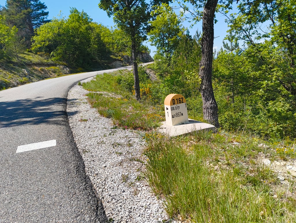
Col d'Ey from Sainte-Jalle via Saint Quenin is a climb in the region Drôme. It is 5.8 km long and bridges 320 m of vertical ascent with an average gradient of 5.6%, resulting in a difficulty score of 224. The top of the ascent is located at 718 m above sea level. Climbfinder users shared 1 review/story of this climb and uploaded 2 photos.

Road name: D 250

4.0 by N_M
This is an automatic translation, the original language is: Dutch.
The ascent of the Col d'Ey along St Quenin is a bit different from the one along the other sides. Here you cut through the middle of fields of vineyards, fruit trees and lavender fields, past a farm and some houses. The ascent is very irregular : first a very slight climb, a descent and a steeper section before coming out on the larger but quiet road up to the col.... read more

Photos (2)

Col d'Ey from Sainte-Jalle via Saint Quenin
transparant thumb
transparant thumb
transparant thumb
transparant thumb

Your uploads (max 4)

Welcome! Please activate your account if you would like to share something. Look for the verification email in your inbox.

If you want to upload your photos, you need to create an account. It only takes 1 minute and it's completely free.

  • Receive free climbfinder goodies for your reviews & photos.
  • Create a bucket list and check off conquered climbs.
  • Add missing climbs.
Continue with GoogleContinue with Google Continue with FacebookContinue with Facebook Continue with AppleContinue with Apple Sign up with email
By signing up you agree to our terms of service and confirm that you have read our privacy & content policy.

Reviews (1)

5.0
4.0
3.0
2.0
1.0
N_M
1 y 4.0 via the Climbfinder app
This is an automatic translation, the original language is: Dutch. Show original

The ascent of the Col d'Ey along St Quenin is a bit different from the one along the other sides. Here you cut through the middle of fields of vineyards, fruit trees and lavender fields, past a farm and some houses. The ascent is very irregular : first a very slight climb, a descent and a steeper section before coming out on the larger but quiet road up to the col.

De beklimming van de Col d'Ey langs St Quenin is wat verschillend dan die langs de andere kanten. Hier snij je midden door de velden met wijngaarden, fruitbomen en lavendelvelden, langsheen een boerderij en enkele woningen. De beklimming is heel onregelmatig : eerst een zeer lichte klim, een afdaling en een steiler stuk vooraleer uit te komen op de grotere doch rustige weg tot aan de col.

Col d'Ey from Sainte-Jalle via Saint Quenin
Dashboard

Climbing times

7 km/h 00:49:18
11 km/h 00:31:22
15 km/h 00:23:00
19 km/h 00:18:10

Road surface condition

0% 100% 0%
Based on 1 vote
Share your knowledge. What was the road condition during your ascent?

Traffic

100% 0% 0%
Based on 1 vote
Your experience counts. How much traffic did you encounter during the climb?

Frequently Asked Questions

You don't need special gearing for Col d'Ey from Sainte-Jalle via Saint Quenin. The slope isn't long or steep enough to require much shifting down. You can conquer this climb on power alone. However, a compact gearing system with a smallest front chainring of 34 and largest rear sprocket of 28 or 30 is always nice if you enjoy cycling uphill. This helps maintain a smooth cadence.

Col d'Ey from Sainte-Jalle via Saint Quenin is a 3rd-category climb. Almost anyone can handle this climb, as long as you have a bike with climbing gears. If you have little training, you will probably need to shift down significantly. For experienced riders, Col d'Ey from Sainte-Jalle via Saint Quenin is not a problem.

Col d'Ey from Sainte-Jalle via Saint Quenin is 5.8 km long.

The average gradient of Col d'Ey from Sainte-Jalle via Saint Quenin is 5.6%.

Col d'Ey from Sainte-Jalle via Saint Quenin has a steepest segment with an average gradient of 10.6%.

The summit of Col d'Ey from Sainte-Jalle via Saint Quenin is at 718 m.

At a slow pace of 7 km/h, it takes about 00:49:18 to climb Col d'Ey from Sainte-Jalle via Saint Quenin. At 11 km/h the time is 00:31:22, and at 15 km/h 00:23:00. For the fastest cyclists, 00:18:10 is an achievable time.

Col d'Ey from Sainte-Jalle via Saint Quenin is located in the region Drôme in France.

This page is better in the app

Climbfinder app
Climbfinder
(Free)
Open