View on map
© MapLibre | OpenStreetMap contributors
1%
2%
4%
6%
8%
10%
12%
15%
20%

Col d'Aubisque from Arrens

5.0
2 reviews | Elevation profile | 2 photos
Tips nearby
Col d'Aubisque from Arrens
transparant thumb
transparant thumb
transparant thumb
transparant thumb
transparant thumb
transparant thumb
Your achievable time
Calculating based on your best performances...
Relaxed
Maximum
W/kg
W/kg
W/kg
Analyse your climbing performance
Detailed insight into your climbing performance & automatically check off climbs
Based on your best performances.
Your best attempt:
Number of attempts:
Elevation profile Col d'Aubisque from Arrens

Statistics

Difficulty points 714
Length 17.2 km
Average gradient 5.5%
Steepest 100 metres 11%
Total ascent 949 m
Feedback about this climb?
Show climbs nearby Export to GPS device

Col d'Aubisque from Arrens is a climb in the region Hautes-Pyrénées. It is 17.2 km long and bridges 949 m of vertical ascent with an average gradient of 5.5%, resulting in a difficulty score of 714. The top of the ascent is located at 1710 m above sea level. Climbfinder users shared 2 reviews of this climb and uploaded 2 photos.

Road names: Route du Soulor & D 918
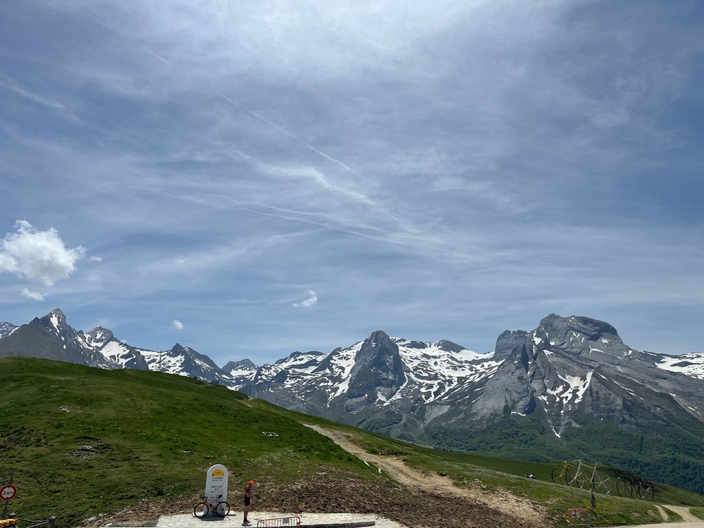
5.0 by Sybren
This is an automatic translation, the original language is: Dutch.
From Attens, we did this climb. The first section is punchy and at the top we satisfy our legs. The section to the Aubisque starts with a descent and the route is mild in terms of gradient. The last kilometres head towards 7.5% again and so the devil is in the tail again. At the top, it's actually dregs! Ugly, barren. The descent is as always a reward for all the work.... read more

Photos (2)

Col d'Aubisque from Arrens
transparant thumb
transparant thumb
transparant thumb
transparant thumb

Your uploads (max 4)

Welcome! Please activate your account if you would like to share something. Look for the verification email in your inbox.

If you want to upload your photos, you need to create an account. It only takes 1 minute and it's completely free.

  • Receive free climbfinder goodies for your reviews & photos.
  • Create a bucket list and check off conquered climbs.
  • Add missing climbs.
Continue with GoogleContinue with Google Continue with FacebookContinue with Facebook Continue with AppleContinue with Apple Sign up with email
By signing up you agree to our terms of service and confirm that you have read our privacy & content policy.

Reviews (2)

5.0
4.0
3.0
2.0
1.0
Sybren
10 Mo 5.0 02:10:00 (7.9 km/h)
This is an automatic translation, the original language is: Dutch. Show original

From Attens, we did this climb. The first section is punchy and at the top we satisfy our legs. The section to the Aubisque starts with a descent and the route is mild in terms of gradient. The last kilometres head towards 7.5% again and so the devil is in the tail again. At the top, it's actually dregs! Ugly, barren. The descent is as always a reward for all the work.

Vanuit Attens deze beklimming gedaan. Het eerste gedeelte is pittig en bovenaan voldoen wij de beentjes. Het stuk naar de Aubisque begint met een afdaling en de route is qua stijgingspercentage mild. De laatste kilometer gaan weer richting 7.5% en zo zit ook het venijn weer in de staart. Boven is het eigenlijk bagger! Lelijk, kaal. De afdaling is weer als altijd een beloning voor al het werk.

Dashboard
pierre81
11 Mo 5.0
This is an automatic translation, the original language is: French. Show original

A splendid climb through marvellous scenery. The road is in very good condition, with the Tour de France passing by regularly. Beware of the traffic though. The gradients are sometimes steep up to Soulor, but the final climb to Aubisque is fairly gentle. A snack bar at the top of each pass for refreshments.

Une montée splendide à travers des paysages merveilleux. La route est en très bon état avec le passage très régulier du Tour de France. Attention tout de même à la circulation. Les pourcentages sont parfois rudes jusqu'au Soulor, mais la montée finale vers l'Aubisque est assez tranquille. Un snack bar au sommet de chaque col pour se restaurer

Dashboard

Climbing times

7 km/h 02:27:19
11 km/h 01:33:44
15 km/h 01:08:44
19 km/h 00:54:16

Road surface condition

0% 100% 0%
Based on 2 votes
Share your knowledge. What was the road condition during your ascent?

Traffic

0% 50% 50%
Based on 2 votes
Your experience counts. How much traffic did you encounter during the climb?

Frequently Asked Questions

Col d'Aubisque can be cycled from 4 sides. Col d'Aubisque from Laruns is the most popular side, but the summit can also be reached via Col d'Aubisque from Argelès Gazost via Col du Soulor, Col d'Aubisque from Arthez d'Asson & Col d'Aubisque from Arrens.

You don't need special gearing for Col d'Aubisque from Arrens. The slope isn't long or steep enough to require much shifting down. You can conquer this climb on power alone. However, a compact gearing system with a smallest front chainring of 34 and largest rear sprocket of 28 or 30 is always nice if you enjoy cycling uphill. This helps maintain a smooth cadence.

Col d'Aubisque from Arrens is a first-category climb: long and tough. Do not underestimate this climb. Many famous Tour de France cols fall into this category. Prepare for a long, challenging ride. Only well-trained riders will reach the top smoothly. Make sure you have a road bike with climbing gears and enough training; otherwise, it will be a struggle.

Col d'Aubisque from Arrens is 17.2 km long.

The average gradient of Col d'Aubisque from Arrens is 5.5%.

Col d'Aubisque from Arrens has a steepest segment with an average gradient of 11%.

The summit of Col d'Aubisque from Arrens is at 1710 m.

At a slow pace of 7 km/h, it takes about 02:27:19 to climb Col d'Aubisque from Arrens. At 11 km/h the time is 01:33:44, and at 15 km/h 01:08:44. For the fastest cyclists, 00:54:16 is an achievable time.

Col d'Aubisque from Arrens is located in the region Hautes-Pyrénées in France.

This page is better in the app

Climbfinder app
Climbfinder
(Free)
Open