| Hidden gem |
| 10 hairpin turns |
| #69 toughest climb of Haute Savoie |
| #45 most elevation gain of Haute Savoie |
| #59 longest climb of Haute Savoie |
| #83 average steepest climb of Annecy |
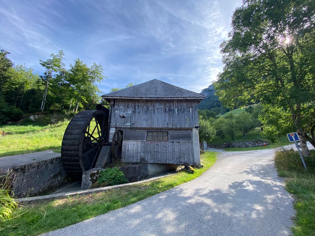
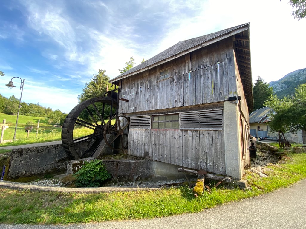
La Perrière from d'Héré is a climb in the region Annecy. It is 10.1 km long and bridges 712 m of vertical ascent with an average gradient of 7%, resulting in a difficulty score of 565. The top of the ascent is located at 1150 m above sea level. Climbfinder users shared 6 reviews of this climb and uploaded 29 photos.
Road names: Route d'Entrevernes & Route de la Montagne
4.0 by MarcoGThis is an automatic translation, the original language is: Dutch.Did the climb on a hot morning, especially in the first part almost no shade. Climbs street robbing into an old village, then goes with some nice hairpin bends into higher grasslands with lots of cows and bells! After the village keep right, road is possibly listed as not accessible : we are three stretches where asphalt is gone and temporarily coarse gravel. 1 stretch is about 400 metres and not fine for racing bikes, other stretches are several tens of metres long. The paving finally ends at a... read more
Welcome! Please activate your account if you would like to share something. Look for the verification email in your inbox.
If you want to upload your photos, you need to create an account. It only takes 1 minute and it's completely free.
Did the climb on a hot morning, especially in the first part almost no shade. Climbs street robbing into an old village, then goes with some nice hairpin bends into higher grasslands with lots of cows and bells! After the village keep right, road is possibly listed as not accessible : we are three stretches where asphalt is gone and temporarily coarse gravel. 1 stretch is about 400 metres and not fine for racing bikes, other stretches are several tens of metres long. The paving finally ends at a car park with nothing else but a nice view of the cliff to the west of you. By mountain bike fine to continue to the Col a few kilometres of unpaved road. Climb is nicely constant, contains nice hairpin turns, alternating village, meadow and forest. Nice views of the surroundings.
Op een warme ochtend de klim gedaan, zeker in het eerste deel vrijwel geen schaduw. Klimt straatroof in een oud dorpje, en gaat dan met een paar mooie haarspeldbochten naar de hoger gelegen graslanden met veel koeien en bellen! Na het dorpje rechts aanhouden, weg staat mogelijk als niet toegangkelijk : we zijn drie stukken waar asfalt weg is en tijdelijk grove gravel ligt. 1 stuk is ca 400 meter en niet fijn voor de race fiets, ander stukken zijn enkele tientallenmeters lang. De verharding eindigt definitief bij een parkeerplaats met verder niks als een aardig uitzicht op de rotswand te westen van je. Met de mountainbike prima om door te rijden naar de Col een paar kilometer onverharde weg. Klim is mooi constant, bevat leuke haarspeldbochten, afwisselde dorp, wei en bos. Mooie uitzichten op de omgeving.
A few years ago I climbed this route on my own, without ever imagining that one day I would find it on Climbfinder, which made me want to go back and post a fresh review and some photos.
Tuesday 3 September 2024 with Éric.
The start is at the end of the cycle path and the junction with the Rte d'Entrevernes, with the Château de D'Héré just above.
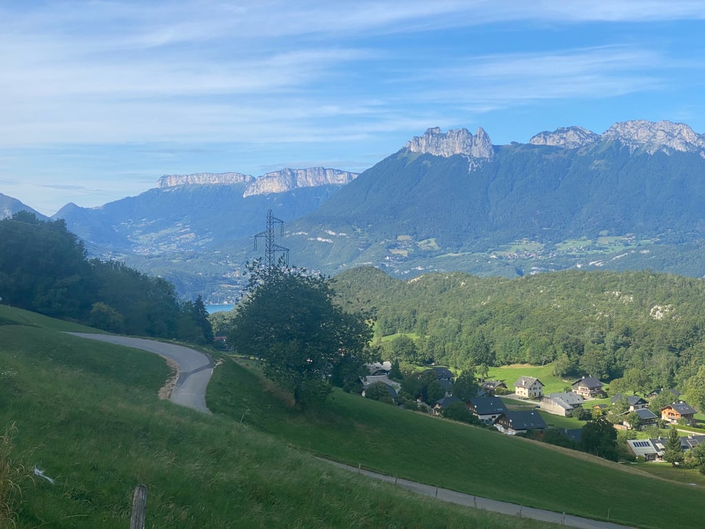
The road to Entrevernes is wide and steep, with views of Lake Annecy.
1.5 km before the village a long straight with gradients between 8-9... tiring.
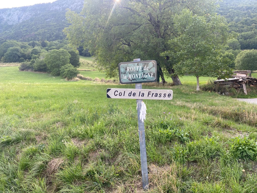
Just outside Entrevernes, take the right-hand road that winds through the mountain pastures, with 5km to go. On 3 September 2024, there were 3 tricky sections that were difficult to pass on the bike because the tarmac was washed away during the recent bad weather, see one of the photos.
The finish is at a tiny car park at La Perrière, which is impossible to continue on a road bike.
There's no shade even in the morning on this side of the mountain, just the last kilometre, the best views are on the descent, the village of Entrevernes from the switchbacks above and with a bit of luck, as was the case today, glimpses of paragliders above the trees approaching the landing area at Doussard.
Also, at the end of the descent, a beautiful view of the lake and the châteaux of D'Héré and Duingt, magnificent!
Ps: Beautiful ascent on a good to average road, with very little traffic and dreamy scenery.
Il y a quelques années j'avais effectué cette ascension chemin faisant sans me douter un jour de la trouver avec plaisir sur Climbfinder , ce qui m'a donné envie d'y retourner afin de poster un avis frais et aussi des photos.
Mardi 3 septembre 2024 avec Éric.
Le départ se situe à la sortie de la piste cyclable et le croisement de la Rte d'Entrevernes, on aperçois le Château de D'Héré juste au dessus.
Jusqu'à Entrevernes belle Rte large et à pentes soutenues , quelques vues sur le Lac d'Annecy.
1,5 km avant le village une longue ligne droite dans des pourcentages entre 8-9... usante.
Juste à la sortie d'Entrevernes il faut prendre la Rte à droite qui serpente dans les alpages, il reste 5km , le 3 septembre 2024 il y avait 3 passages délicats qui étaient difficiles de passer sur le vélo car le goudron a été emporté lors des dernières intempéries, voir l'une des photos.
Le final se situe sur un tout petit parking au lieu dit La Perrière, en vélo de Route impossible de continuer.
Pas d'ombre même le matin sur ce versant de montagne, juste le dernier kilomètre, les plus belles vues sont lors de la descente, village d'Entrevernes depuis les lacets du dessus et avec un peu de chance comme ce fut le cas ce jour, apercevoir les parapentes au dessus des arbres qui approchent de l'aire d'atterrissage de Doussard.
Aussi sur la fin de descente une très belle vue sur le lac et les châteaux de D'Héré et de Duingt, magnifique!
Ps : Belle ascension sur une Rte bonne à moyenne, avec très peu de circulation et dans des paysages de rêves.
Lovely climb: excellent tarmac (certainly until halfway), continuous concerts of jingling cow bells and a road that winds endlessly. Halfway (Entrevernes) the legs get some rest and you turn right for a climb between meadows and through a (cool) forest. After about 9 km it goes downhill for a while (not the end yet) and you have another kilometre to where a rough forest road starts. That's where it stopped for me. Too bad there is no real sign with the altimeters.
Heerlijke klim: prima asfalt (zeker tot halfweg), continu concerten van klingelende koebellen en een weg die eindeloos kronkelt. Halfweg (Entrevernes) krijgen de benen wat rust en sla je rechtsaf voor een klim tussen de weilanden en door een (koel) bos. Na pakweg 9 km gaat het even bergaf (nog niet het einde) en heb je nog een kilometer tot waar een ruwe bosweg begint. Daar stopte het voor mij. Jammer dat er geen echt bordje met de hoogtemeters staat.
Nice climb, very calm.
You can go to the Col de la Frasse but you need to have mountain back, gravel will be enough!
Nice climb, very calm.
You can go to the Col de la Frasse but you need to have mountain back, gravel wont be enough!
It is indeed a wonderful climb. Because it is a dead end, there is only local traffic (a few farmers and some hikers with cars).
The climb is fairly even and nowhere super difficult (max 11%). In high summer, however, it is best not to do it in the middle of the day; there is some shade only at the end in the steeper forest. At the 'top' there is a water stream with which you can cool down / refill your water bottle.
Absolutely recommended!
Inderdaad een heerlijke klim. Doordat het dood loopt is er alleen bestemmingsverkeer (enkele boeren en wat hikers met de auto).
De klim is redelijk gelijkmatig en nergens superlastig (max 11%). Hoog zomer wel één om niet midden op de dag te doen; alleen aan het einde in het steilere bos is wat schaduw. Op de ‘top’ is een waterstroom waarmee je je kunt afkoelen/bidon kunt bijvullen.
Absoluut een aanrader!
What a diamond of a climb this is... The road winds beautifully upwards over fresh asphalt and finally gives you the feeling you've been looking for so long in this tourist region: the conviction that this mountain is yours alone. A wide view on the lake through the open fields, a deserted village with a mountain water tap, cowbells ringing, a part through the forest that reminds you of the Vosges, ... I take my hat off to this brilliant climb! (What a pity it doesn't go through and thus ends in a dead end, but anyway, the descent is just as impressive, with the lake and the sharp toothed mountains in the foreground!)
Wat een diamant van een beklimming dit… De weg slingert schitterend naar boven over vers asfalt en geeft je in deze toeristische regio eindelijk eens het gevoel waar je zolang naar zoekt: de overtuiging dat deze berg van jou alleen is. Een weids zicht op het meer door de open velden, een godverlaten dorpje met bergwaterkraantje, klingelende koeienbellen, een stuk door het bos dat je aan de Vogezen doet denken, … Mijn hoedje af voor deze briljanten beklimming! (Wat jammer dat ie niet doorloopt en dus doodloopt, maar soit, de afdaling is even indrukwekkend, met het meer en de spitse getande bergen in de voorgrond!)
| 7 km/h | 01:26:49 |
| 11 km/h | 00:55:14 |
| 15 km/h | 00:40:30 |
| 19 km/h | 00:31:59 |
This page is better in the app