Tips nearby


Les Deux Alpes via Bons is a climb in the region Isère. It is 6.4 mi long and bridges 2385 ft of vertical ascent with an average gradient of 7.1%, resulting in a difficulty score of 612. The top of the ascent is located at 5449 ft above sea level. Climbfinder users shared 9 reviews of this climb and uploaded 12 photos.
Road name: D220, D213
3.0 by ChristopheC35This is an automatic translation, the original language is: French.I went up to Les 2 Alpes via Lac du Chambon, and then came back down via Bons. From Le Ponteil onwards, the road is in very poor condition, which makes the descent very steep, quite epic and even dangerous - you're shaken all over!... read more
Welcome! Please activate your account if you would like to share something. Look for the verification email in your inbox.
If you want to upload your photos, you need to create an account. It only takes 1 minute and it's completely free.
I went up to Les 2 Alpes via Lac du Chambon, and then came back down via Bons. From Le Ponteil onwards, the road is in very poor condition, which makes the descent very steep, quite epic and even dangerous - you're shaken all over!
Monté aux 2 Alpes par le Lac du Chambon, je suis redescendu par Bons. À partir de Le Ponteil, la route est en très mauvais état, ce qui rend la descente très raide assez épique voire dangereuse, on est secoué de partout !
For me and my partner, it was a leg dump at the end of the ALP D'HUEZ and the COL DU CHAUSSY.
It is still a nice climb, pleasant and not too hard. Full of people going up and down, but there is a wonderful lane at the side of the road especially for bikes.
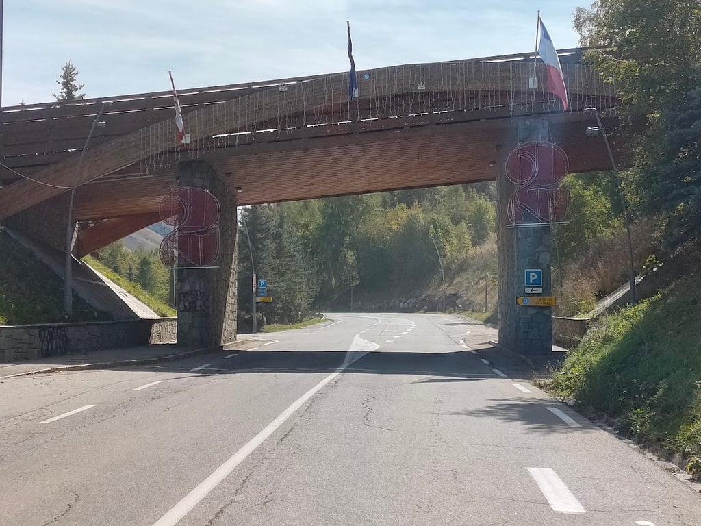
The arrival at the village is nice, you cross the arch and then arrive in the village.
Per me ed il mio socio è stato uno scarico gambe alla fine dell'ALP D'HUEZ e del COL DU CHAUSSY.
è comunque una bella salita, piacevole e non troppo dura. Pieno di gente che sale e scende, ma c'è una splendida corsia a bordo strada apposta per le bici.
L'arrivo al paese è carino, si attraversa l'arco e poi si arriva in paese.
Which alternative would you choose?
Coming from the Auris en Oisans descent:
-or on the main track to the left the short climbing section (2.2 kilometres with 115 metres ascent) with 2 short tunnels combined with the main side of Les Deux Alpes
-or on the main runway to the right the longer stretch with about as much climbing as descending (3.5 kilometres with 64 metres rise and 56 metres fall) with 1 longer tunnel combined with the quieter side of Les Deux Alpes?
Welk alternatief zouden jullie kiezen?
Als je van de afdaling van Auris en Oisans komt:
-ofwel op de grote baan naar links het korte klimmende stuk (2,2 kilometer met 115 meter stijging) met 2 korte tunnels gecombineerd met de hoofdkant van Les Deux Alpes
-ofwel op de grote baan naar rechts het langere stuk met ongeveer evenveel klimmen als dalen (3,5 kilometer met 64 meter stijging en 56 meter daling) met 1 langere tunnel gecombineerd met de rustigere zijkant van Les Deux Alpes?
It's the best route up to the station:
there's very little traffic, it's beautiful and the surface is good.
In short, a real pleasure.
C'est le meilleur itinéraire pour monter à la station :
peu de circulation, c'est très beau, le revêtement est bon.
Bref, un vrai plaisir.
Nice variant of the rather boring climb to ski village Les Deux Alpes. This variant takes you up a steep balcony road, where you are treated to beautiful views. The final kilometres join the wide road towards the ski resort.
Mooie variant van de nogal saaie beklimming naar skidorp Les Deux Alpes. Deze variant breng je via een steile balkonweg naar boven, waarbij je getrakteerd wordt op mooie uitzichten. De laatste kilometers sluiten aan bij de brede weg richting skioord.
Apparently unknown climb / crossing to les deux alpes. But until Bons is just fantastic including 'balcony' . Road to les deux alpes is especially nice for the descent.
Kennelijk onbekende klim / doorsteek naar les deux alpes. Maar tot aan Bons is het gewoon fantastisch inclusief 'balkon' . Weg naar les deux alpes is vooral leuk voor de afdaling.
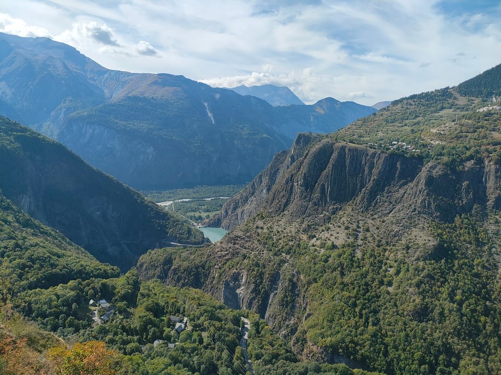
From Bourg d'Oisans, we took an earlier exit near the little chapel. The first few hundred meters are very steep with peaks up to 18%. After that, the gradients decrease a little, but it is still quite steep. After a few kilometres, the climb becomes a lot less steep and you can recover a bit from the first few kilometres. The view is then magnificent, with beautiful panoramas. From the village of Bons you turn onto the busier N road, after which the last few kilometers feel like Alpe d'Huez.
All in all a nice climb, where especially the first few kilometers are really worth it.
Vanuit Bourg d'Oisans hebben wij een afslag eerder genomen ter hoogte van het kapelletje. De eerste paar honderd meter zijn dan super steil met uitschieters naar 18%. Daarna nemen de stijgingspercentages iets af, maar is het nog steeds vrij steil. Na een paar km wordt de klim een stuk minder steil en kan je een beetje herstellen van de eerste kilometers. Het uitzicht is dan schitterend, met prachtige vergezichten. Vanaf het dorpje Bons draai je de drukkere N weg op, waarna de laatste kilometers Alpe d'Huez achtig aanvoelen.
Al met al een leuke klim, waar vooral de eerste kilometers echt de moeite waard zijn.
| 5 mph | 01:17:01 |
| 7 mph | 00:54:32 |
| 9 mph | 00:42:30 |
| 12 mph | 00:31:55 |
This page is better in the app