Kandel from Waldkirch is a climb in the region Black Forest. It is 6.7 mi long and bridges 2920 ft of vertical ascent with an average gradient of 8.2%, resulting in a difficulty score of 807. The top of the ascent is located at 3953 ft above sea level. Climbfinder users shared 8 reviews of this climb and uploaded 6 photos.
This is an automatic translation, the original language is: Dutch.
Climbed it during my vacation in the Black Forest. My first ride there and immediately did the toughest climb in the region.... That was quite a misconception. The first few kilometers are not too bad, but then there is a long middle section where it doesn't go below 8%, with parts above 10%. I really destroyed myself here, especially because it never flattens out.
It is a completely forested climb with the advantage that on hot days it is a good alternative for the more "open&quo...read more
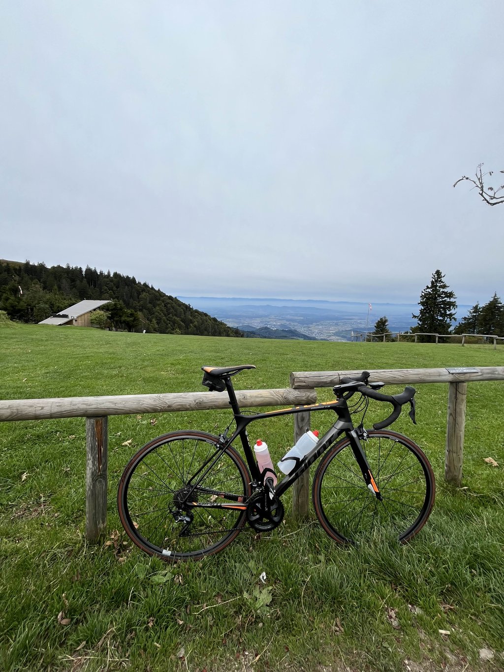
Photos (6)
Welcome! Please activate your account if you would like to share something. Look for the verification email in your inbox.
This is an automatic translation, the original language is: Dutch.
Show original
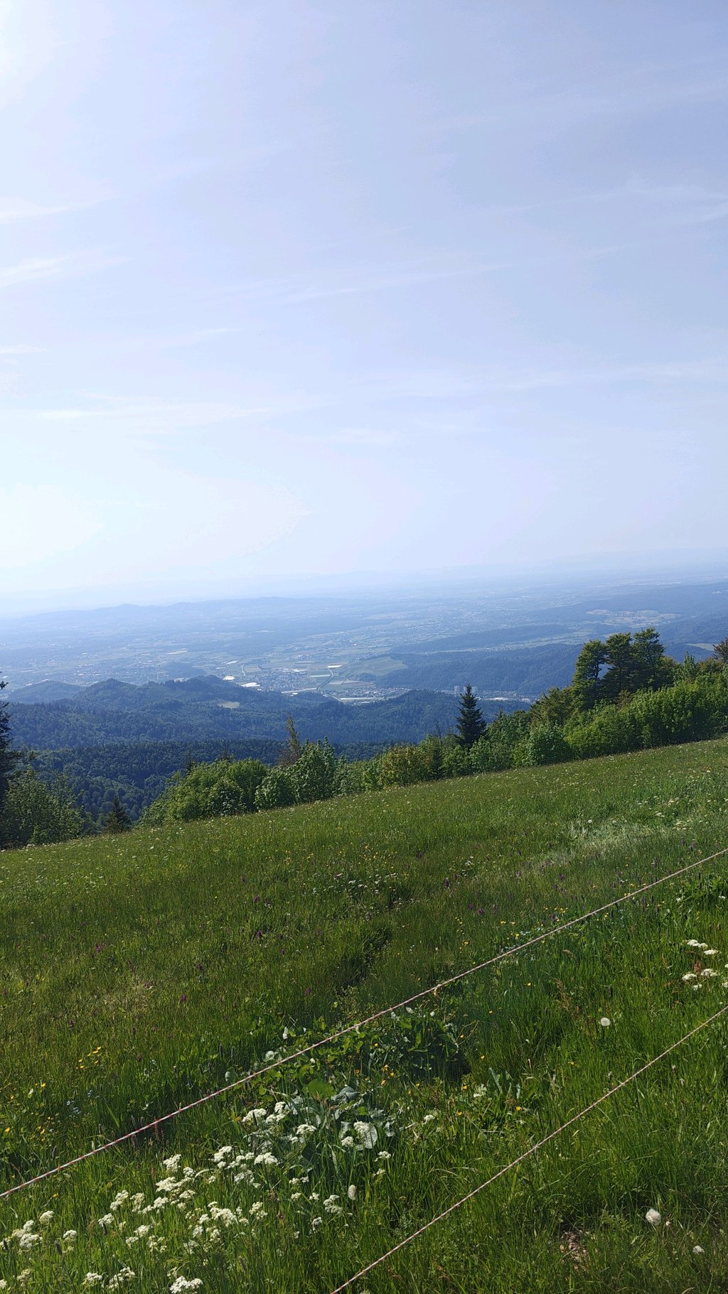
Climbed it on a hot day in May (30+), the climb goes through the forest for the most part, ideal on a hot day. The climb itself is one of the tougher in the region, constantly running into steeper percentages! The reward comes at the very top with a beautiful view.
Heb deze beklommen op een warme dag in mei (30+) de klimt gaat voor een groot deel door het bos, ideaal op een warme dag. De klim zelf is een van de zwaardere in de regio, loopt voordurende tegen de steilere percentages aan! De beloning komt pas helemaal op de top met een mooi uitzicht
This is an automatic translation, the original language is: Dutch.
Show original
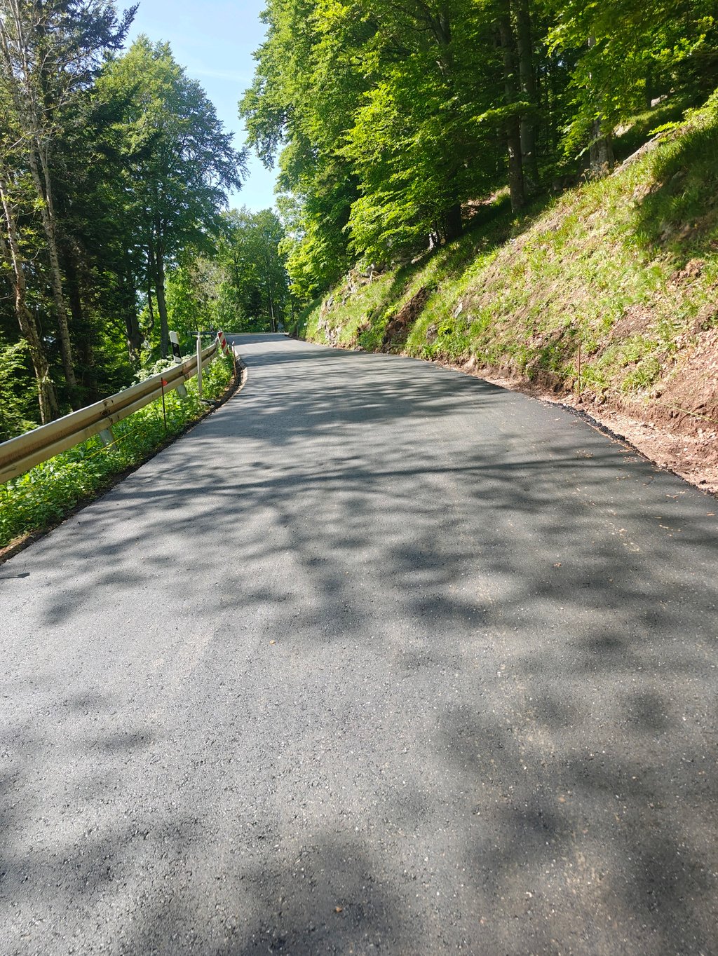
I had read about the work in 2025 and had hoped the road would be finished by now. Unfortunately, on April 30, 2026, it is far from finished. I drove 6 of the 10 km on coarse-grained asphalt (top layer had been removed). The workmen who were busy tolerated me but fine it was not. So for now, best to avoid it. When the road is finished, it will be a very cool climb though! Lots of forest, lots of curves and occasionally nice vistas. So the four stars are for when the road is ready again. 😄
Ik had gelezen over de werkzaamheden in 2025 en had gehoopt dat de weg inmiddels klaar zou zijn. Helaas is deze op 30 april 2026 nog lang niet klaar. Ik heb 6 van de 10 km over grofgeribbeld asfalt gereden (toplaag was verwijderd). De werkmannen die bezig waren hebben me gedoogd maar fijn was het niet. Voor nu dus het beste nog vermijden. Als de weg gereed is, is het wel een hele gave klim! Veel bos, veel bochten en af en toe mooie doorkijkjes. De vier sterren zijn dus voor als de weg weer klaar is. 😄
This is an automatic translation, the original language is: French.
Show original
This is an interesting climb for cyclists looking for a good challenge, off the beaten track.
It combines sustained effort, beautiful scenery and a visual reward at the summit.
Ideal for those already in good physical condition, although not insurmountable.
Beware, however, that the road on the second part of the climb is in poor condition.
C’est une ascension intéressante pour les cyclistes cherchant un bon défi, hors des route ultra fréquentés.
Elle combine effort soutenu, beaux paysages, et récompense visuelle au sommet.
Idéale pour ceux qui ont déjà une bonne condition physique même si pas insurmontable.
Attention cependant sur seconde partie de l'ascension la route est en mauvais était.
This is an automatic translation, the original language is: Dutch.
Show original
Note: currently (July 2025) this climb is closed due to works and this will continue until late summer 2025.
I rode here a few weeks ago to see how far I could get and ended up riding it all the way up by passing work traffic with a bit of difficulty, but officially this is not allowed - so conquer it at your own risk only!
Let op: momenteel (juli 2025) is deze klim afgesloten wegens werkzaamheden en dit zal tot de nazomer van 2025 duren.
Ik reed hier een paar weken geleden om te kijken hoe ver ik kon komen en uiteindelijk heb ik 'm alsnog volledig weten op te rijden door het werkverkeer met een beetje moeite te passeren, maar officieel is dit niet toegestaan – dus bedwing 'm alleen op eigen risico!
This is an automatic translation, the original language is: Dutch.
Show original
On the programme today is the Alpe d'Huez of the Black Forest, the climb named Kandel.
This climb has roughly the same distance, 11 km, and the same gradient of 7.9%.
This is also where the comparison ends immediately.
We ride out of Freiburg on mostly cycle paths and arrive in the village of Waldkirch after 20 km.
Here we take the Kandelstrasse, which will take us to the summit of the Kandel at 1202 m.
It starts off nicely right away with stretches of 14%.
Above the tree line, we enjoy the views.
Personally, I found this climb tougher than the Alpe d'Huez, which in turn is more beautiful and somewhat better known.
If you are in the Black Forest then you should definitely put this one on your record.
Vandaag staat de Alpe d'Huez van het Zwarte Woud op het programma, de klim met de naam Kandel.
Deze klim heeft ongeveer dezelfde afstand, 11 km, en hetzelfde stijgingspercentage van 7,9%.
Hier houdt de vergelijking ook meteen op.
We rijden Freiburg uit via voornamelijk fietspaden en komen na 20 km in het dorp Waldkirch.
Hier pakken we de Kandelstrasse die ons gaat brengen naar de top van de Kandel op 1202 m.
Het begint meteen al weer lekker met stukken van 14%.
Boven de boomgrens is het genieten van het uitzicht.
Persoonlijk vond ik deze klim zwaarder dan de Alpe d'Huez die dan weer mooier is en wat meer bekendheid geniet.
Als je in het Zwarte Woud bent dan moet je deze zeker op je palmares zetten.
This is an automatic translation, the original language is: Dutch.
Show original
This is a beautiful and, with 900 altitude metres and gradients of up to 11%, also a definitely not to be underestimated climb. During midday, you cycle alternately in the sun and shade. The road here and there is not too good, but uphill you won't suffer too much. Should you descend the same road, I would definitely take this into account. All in all, a beautiful climb that is definitely worthwhile.
Dat is een mooie en met 900 hoogtemeters en stijgingspercentages tot 11% ook een zeker niet te onderschatten klim. Tijdens het middaguur fiets je afwisselend in de zon en de schaduw. De weg is her en der niet al te best maar bergop heb je daar niet zo heel veel last van. Mocht je dezelfde weg ook gaan afdalen dan zou ik daar zeker rekening mee houden. Al met al een prachtige klim die zeker de moeite waard is.
This is an automatic translation, the original language is: Dutch.
Show original
A tough and irregular climb. Long stretches of 10-11% are alternated by short flatter ones. The fact that the climb continues through the forest, so there are no views, makes it extra tough. In this respect, it is similar to e.g. the Platzerwasel in the Vosges.
Asphalt in the first half of the climb is excellent. Towards the top, the tarmac is worse with many holes in the road. Many bikers in the weekend.
Pittige, onregelmatige klim. Lange stukken van 10-11% worden afgewisseld door korte vlakkere stukken. Dat de klim continu door het bos gaat, waardoor er geen uitzichten zijn, maakt het extra zwaar. Wat dat betreft vergelijkbaar met bijv. de Platzerwasel in de Vogezen.
Asfalt in de eerste helft van de klim is uitstekend. Richting de top wordt het asfalt slechter met veel gaten in de weg. Veel motorrijders in het weekend.
This is an automatic translation, the original language is: Dutch.
Show original
Climbed it during my vacation in the Black Forest. My first ride there and immediately did the toughest climb in the region.... That was quite a misconception. The first few kilometers are not too bad, but then there is a long middle section where it doesn't go below 8%, with parts above 10%. I really destroyed myself here, especially because it never flattens out.
It is a completely forested climb with the advantage that on hot days it is a good alternative for the more "open" climbs in the area. Disadvantage is that only at the top you are treated to a truly phenomenal view. During the climb you see nothing but trees, which in my opinion gives it a certain mystique.
All in all, I found this a really tough climb, maybe because my legs weren't used to climbing yet, but I don't think I'm saying too much if this is a big ordeal for every cyclist from the polder.
Beklommen tijdens mijn vakantie in het Zwarte Woud. Mijn eerste rit daar en direct de zwaarste klim in de regio gedaan... Dat was een behoorlijke misvatting. De eerste paar kilometers zijn nog prima te doen, maar dan volgt een lang middendeel waar het niet meer onder de 8% gaat, met hele stukken boven de 10%. Ik reed mezelf hier aardig de vernieling in, vooral doordat het nergens afvlakte.
Het is een klim die volledig in het bos ligt met als voordeel dat het op warme dagen een goed alternatief is voor de meer "open" beklimmingen in de omgeving. Nadeel is dat je pas op de top wordt getrakteerd op een werkelijk fenomenaal uitzicht. Tijdens de klim zie je niets anders dan bomen, wat het in mijn ogen ook wel een bepaalde mystiek geeft.
Al met al vond ik dit echt wel een heel zware klim, misschien dus omdat mijn benen het klimmen nog niet gewend waren, maar ik denk dat ik niks te veel zeg als dit voor iedere fietser uit de polder een flinke beproeving is.
Kandel from Waldkirch is a challenging ascent. For this type of climbing, we recommend mountain gearing, specifically a compact system. This means a small front chainring of 34 teeth, combined with a rear cassette where, depending on your level, strength, and experience, you choose a sprocket with 30, 32, or even 34 teeth. Remember that a smooth cadence is always more efficient!
Kandel from Waldkirch is a first-category climb: long and tough. Do not underestimate this climb. Many famous Tour de France cols fall into this category. Prepare for a long, challenging ride. Only well-trained riders will reach the top smoothly. Make sure you have a road bike with climbing gears and enough training; otherwise, it will be a struggle.
Kandel from Waldkirch is 6.7 mi long.
The average gradient of Kandel from Waldkirch is 8.2%.
Kandel from Waldkirch has a steepest segment with an average gradient of 14.9%.
The summit of Kandel from Waldkirch is at 3953 ft.
At a slow pace of 5 mph, it takes about 01:21:15 to climb Kandel from Waldkirch. At 7 mph the time is 00:57:31, and at 9 mph 00:44:50. For the fastest cyclists, 00:33:41 is an achievable time.
Kandel from Waldkirch is located in the region Freiburg in Germany.