| Famous climb |
| #21 toughest climb of Haute Ardenne |
| #89 most elevation gain of Valleys of the Vesdre, de l'Amblève et de l'Ourthe |
| #39 longest climb of Haute Ardenne |
| #34 average steepest climb of Haute Ardenne |
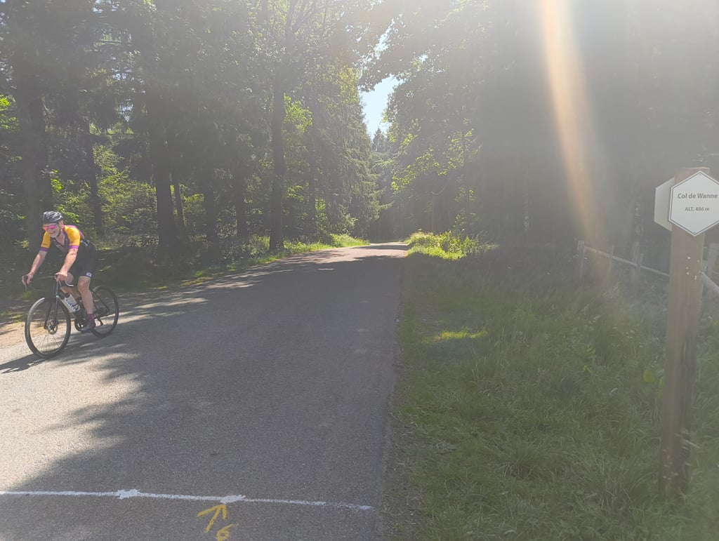
Côte de Wanne via Spineux is a climb in the region Haute Ardenne. It is 1.9 mi long and bridges 636 ft of vertical ascent with an average gradient of 6.3%, resulting in a difficulty score of 129. The top of the ascent is located at 1627 ft above sea level. Climbfinder users shared 9 reviews of this climb and uploaded 2 photos.
Road names: Spineux & Faix du Diable
4.0 by JurneSleddensThis is an automatic translation, the original language is: Dutch.A friendly alternative of the Wanne where you can still enjoy the beautiful and peaceful surroundings. Highly recommended! The descent (towards Stavelot) is always be careful.... read more
Welcome! Please activate your account if you would like to share something. Look for the verification email in your inbox.
If you want to upload your photos, you need to create an account. It only takes 1 minute and it's completely free.
A friendly alternative of the Wanne where you can still enjoy the beautiful and peaceful surroundings. Highly recommended! The descent (towards Stavelot) is always be careful.
Een vriendelijk alternatief van de Wanne waarbij je toch wel kunt genieten van de mooie en rustige omgeving. Aanrader! De afdaling (richting Stavelot) is wel altijd oppassen
Smooth climb from Spineux with a brisk but steady start. The first kilometer runs smoothly but persistently uphill, followed by a slightly calmer middle section with open sections and views over the hilly countryside. The finale goes up again towards the forest, where the pace feels a bit heavier.
Mainly a rhythm climb with no real peaks, but one that you constantly feel in your legs.
Gelijkmatige klim vanuit Spineux met een stevige maar constante start. De eerste kilometer loopt vlot maar aanhoudend omhoog, daarna volgt een iets rustiger middenstuk met open stukken en zicht over het heuvellandschap. Het slot gaat opnieuw omhoog richting het bos, waar het tempo wat zwaarder aanvoelt.
Vooral een ritme-klim zonder echte uitschieters, maar wel eentje die je constant in de benen voelt.
Nice climb passing the monument of 'The Battle of the Bulge' before you enter the LBL-part of Côtes de Wanne. Make a huge thank you to those brave soldiers who secured our freedom when the legs hurt. This is not real pain compared to what they faced in December 44 and January 45.
A fairly long Ardennes scale climb, a nice climb not too difficult, with a max. percentage of 10%, the last part being more rolling.
Une côte assez longue à l'échelle ardennaise, une belle côte pas trop difficile, avec un pourcentage max. de 10%, la dernière partie étant plus roulante.
Good climb that is not extremely hard. I like the other climb of the cote de Wanne better because it is more difficult and the views are more beautiful.
Prima beklimming die nergens extreem zwaar is. De andere beklimming van de cote de Wanne vind ik wel leuker omdat die pittiger is en de vergezichten daar wat mooier zijn.
Actually, this side of the Wanne is a nicer side than the 'real' which starts from Grand-Halleux and is also climbed in Liège-Bastogne-Liège. She is especially smoother. The LBL side, for example, has a bit of a descent and then another steeper part, while the this one always goes uphill, but always stays under 10%.
TIP: Also try to take the road to the left in the third turn (which turns right). That one won't climb as long as this one, but it is a bit steeper, I think. Once you're in the forest, it doesn't really climb anymore, but it goes rather flat to false flat. Once you're in the village (well, hamlet) of Aisomont, you continue to the right and that's how you get to the top of Wanne.
Eigenlijk is deze kant van de Wanne een toffere kant dan de 'echte' die vanuit Grand-Halleux vertrekt en ook in Luik-Bastenaken-Luik wordt beklommen. Ze is vooral gelijkmatiger. De LBL-kant heeft bijvoorbeeld een stukje afdaling en dan weer een steiler stuk, terwijl de deze altijd bergop gaat, maar altijd onder de 10% blijft.
TIP: Probeer ook eens om in de derde bocht (die naar rechts draait) het weggetje naar links te nemen. Dat blijft wel niet zo lang meer klimmen als de deze, maar het is volgens mij wel een stukje steiler. Eenmaal je in het bos bent, klimt het dan niet meer echt, maar gaat het eerder vlak tot vals-plat. Eenmaal je in het dorpje (nu ja, gehuchtje) Aisomont bent, vervolg je naar rechts en zo kom je ook boven in Wanne.
Sjoerd is right: the "côte de Wanne" from the last editions of Liège-Bastogne-Liège doesn't really have much to do with this climb. It's a mix between the start of the neighbouring côte de Neuville and the end of the real côte de Wanne (Grand-Halleux).
Sjoerd heeft gelijk: de "côte de Wanne" uit de laatste edities van Luik-Bastenaken-Luik heeft eigenlijk weinig te maken met deze klim. Het is een mix tussen het begin van de naburige côte de Neuville en het einde van de echte côte de Wanne (Grand-Halleux).
A challenging variant of this climb is to turn left in Spineux, where the road turns right at the war monument, into the 'route forestière'. This is a small road that climbs very steeply for a while. Then you follow it through the forest until Aisomont.
Een uitdagende variant bij deze klim is om in Spineux, waar de weg naar rechts draait bij het oorlogsmonument, linksaf te slaan, de 'route forestière' in. Dit is een klein weggetje wat nog een stuk zeer steil omhoog loopt. Daarna volg je nog een stuk door het bos tot in Aisomont.
In Liège Bastogne Liège is driven differently than on the above map. You do not drive via Spineux but via Neuville and Vau.
In Luik Bastenaken Luik wordt deze anders gereden dan op bovenstaand kaartje. Men rijdt niet via Spineux maar via Neuville en Vau
| 5 mph | 00:23:10 |
| 7 mph | 00:16:24 |
| 9 mph | 00:12:47 |
| 12 mph | 00:09:36 |
This page is better in the app