View on map
© MapLibre | OpenStreetMap contributors
1%
2%
4%
6%
8%
10%
12%
15%
20%

Col de Sainte Marie

2.3
4 reviews | Elevation profile | 10 photos
Tips nearby
Col de Sainte Marie
Col de Sainte Marie
Col de Sainte Marie
Col de Sainte Marie
Col de Sainte Marie
Col de Sainte Marie
Col de Sainte Marie
Col de Sainte Marie
Your achievable time
Calculating based on your best performances...
Relaxed
Maximum
W/kg
W/kg
W/kg
Analyze your climbing performance
Detailed insight into your climbing performance & automatically check off climbs
Based on your best performances.
Your best attempt:
Number of attempts:
Elevation profile Col de Sainte Marie

Statistics

Difficulty points 332
Length 3.9 mi
Average gradient 6.5%
Steepest segment 13.7%
Total ascent 1345 ft

Short recap

1 hairpin turn
#92 toughest climb of Grand Est
#65 most elevation gain of Upper Rhine
#70 longest climb of Upper Rhine
#73 average steepest climb of Upper Rhine
Feedback about this climb?
Show climbs nearby Export to GPS device

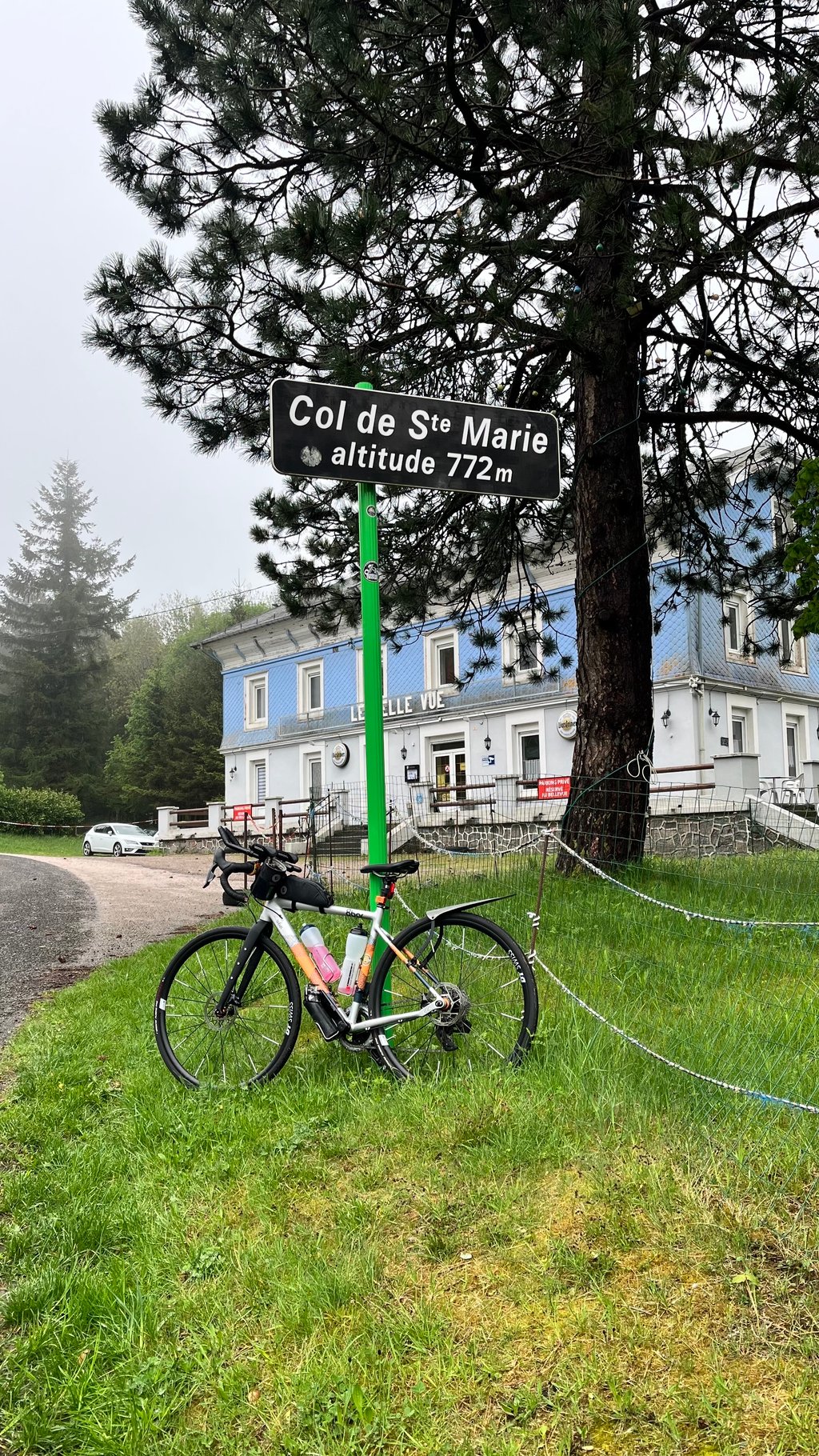
Col de Sainte Marie is a climb in the region Upper Rhine. It is 3.9 mi long and bridges 1345 ft of vertical ascent with an average gradient of 6.5%, resulting in a difficulty score of 332. The top of the ascent is located at 2533 ft above sea level. Climbfinder users shared 4 reviews of this climb and uploaded 10 photos.

Road name: D459

2.0 by sim72
This is an automatic translation, the original language is: French.
Steady climb, quite difficult on the final section. Be careful on the descent on the other side because of the steep slope and rough road.... read more

Photos (10)

Col de Sainte Marie
Col de Sainte Marie
Col de Sainte Marie
Col de Sainte Marie
Col de Sainte Marie
Col de Sainte Marie
Col de Sainte Marie
Col de Sainte Marie
Col de Sainte Marie
Col de Sainte Marie
transparant thumb
transparant thumb

Your uploads (max 4)

Welcome! Please activate your account if you would like to share something. Look for the verification email in your inbox.

If you want to upload your photos, you need to create an account. It only takes 1 minute and it's completely free.

  • Receive free climbfinder goodies for your reviews & photos.
  • Create a bucket list and check off conquered climbs.
  • Add missing climbs.
Continue with GoogleContinue with Google Continue with FacebookContinue with Facebook Continue with AppleContinue with Apple Sign up with email
By signing up you agree to our terms of service and confirm that you have read our privacy & content policy.

Reviews (4)

5.0
4.0
3.0
2.0
1.0
sim72
10 Mo 2.0
This is an automatic translation, the original language is: French. Show original

Steady climb, quite difficult on the final section. Be careful on the descent on the other side because of the steep slope and rough road.

Montée régulière et assez difficile sur sa partie finale. Attention à la descente de l'autre côté en raison de la pente raide et d'une route rugueuse

Dashboard
ted_gluxe
1 y 2.0 via the Climbfinder app

Busy road, since a lot of drivers don’t want to pay for the tunnel. Still, on a quiet day, nice climb with steady and reasonably challenging gradient. Tip for the col sign photo: ride past the sign in this direction and stop by the blue house - more space and no ditch in the way!

Col de Sainte Marie
Col de Sainte Marie
Col de Sainte Marie
Col de Sainte Marie
Dashboard
DudneyRebel
1 y 2.0
This is an automatic translation, the original language is: Dutch. Show original

The first part of the climb out of the village goes up at low percentages. Where the forest starts, the climb begins. Percentage is continuously around 8/9 per cent, but it's a nice runner so once you find a pleasant number of turns you get to the top just fine. There is (indeed) still quite a bit of traffic which makes for a somewhat restless climb. In the last few hundred metres there is another wobble to 11 per cent. Nice wide descent that, with the exception of the two hairpins and the "S" in between, can be ridden at speed.

Het eerste stuk van de klim het dorp uit gaat met lage percentages omhoog. Waar het bos begint, begint de klim. Percentage ligt continue rond de 8/9 procent, maar het is een mooie loper dus als je eenmaal een prettig aantal omwentelingen hebt gevonden kom je goed boven. Er is (inderdaad) nog redelijk wat verkeer wat het wat onrustig klimmen maakt. In de laatste paar honderd meter zit nog een wippertje naar 11 procent. Mooie ruime afdaling die, met uitzondering van de twee haarspelden en de daar tussen in liggende "S", op snelheid gereden kan worden.

Dashboard
JurneSleddens
2 y 3.0
This is an automatic translation, the original language is: Dutch. Show original

As far as I am concerned, the first two kilometres could be taken off. This is valsplat through the (extinct) village uphill. Just before the right-hand bend, the real work begins. The road surface is good but there is still quite a bit of traffic (despite the tunnel underneath). It is quite steep but also has some flatter sections so it is not too hard. At the end there is a nice view. The descent to Wisembach is lovely!

Wat mij betreft zouden de eerste twee kilometers eraf kunnen. Dit is valsplat door het (uitgestorven) dorpje omhoog. Iets voor de bocht naar rechts begint het echte werk. Het wegdek is goed maar er rijdt (ondanks de tunnel eronder) nog best wat verkeer. Hij is vrij steil maar heeft ook wat vlakkere stukken waardoor ie niet super zwaar is. Op het laatst ook nog een mooi uitzicht. De afdaling naar Wisembach is heerlijk!

Col de Sainte Marie
Col de Sainte Marie
Col de Sainte Marie
Col de Sainte Marie
Dashboard

Climbing times

5 mph 00:47:36
7 mph 00:33:42
9 mph 00:26:15
12 mph 00:19:43

Road surface condition

100% 0% 0%
Based on 1 vote
Share your knowledge. What was the road condition during your ascent?

Traffic

0% 0% 100%
Based on 1 vote
Your experience counts. How much traffic did you encounter during the climb?

Frequently Asked Questions

Col de Sainte Marie can be cycled from 2 sides. Col de Sainte Marie from Sainte Marie aux Mines is the most popular side, but the summit can also be reached via Col de Sainte Marie from Raves.

Col de Sainte Marie is a challenging ascent. For this type of climbing, we recommend mountain gearing, specifically a compact system. This means a small front chainring of 34 teeth, combined with a rear cassette where, depending on your level, strength, and experience, you choose a sprocket with 30, 32, or even 34 teeth. Remember that a smooth cadence is always more efficient!

Col de Sainte Marie is a serious climb and falls into the 2nd category. With a good basic fitness level, even without much cycling experience, you can complete this climb just fine. However, a bike with climbing gears is a must. Without experience or training, it will be really tough – but that’s part of the challenge!

Col de Sainte Marie is 3.9 mi long.

The average gradient of Col de Sainte Marie is 6.5%.

Col de Sainte Marie has a steepest segment with an average gradient of 13.7%.

The summit of Col de Sainte Marie is at 2533 ft.

At a slow pace of 5 mph, it takes about 00:47:36 to climb Col de Sainte Marie. At 7 mph the time is 00:33:42, and at 9 mph 00:26:15. For the fastest cyclists, 00:19:43 is an achievable time.

Col de Sainte Marie is located in the region Upper Rhine in France.

This page is better in the app

Climbfinder app
Climbfinder
(Free)
Open