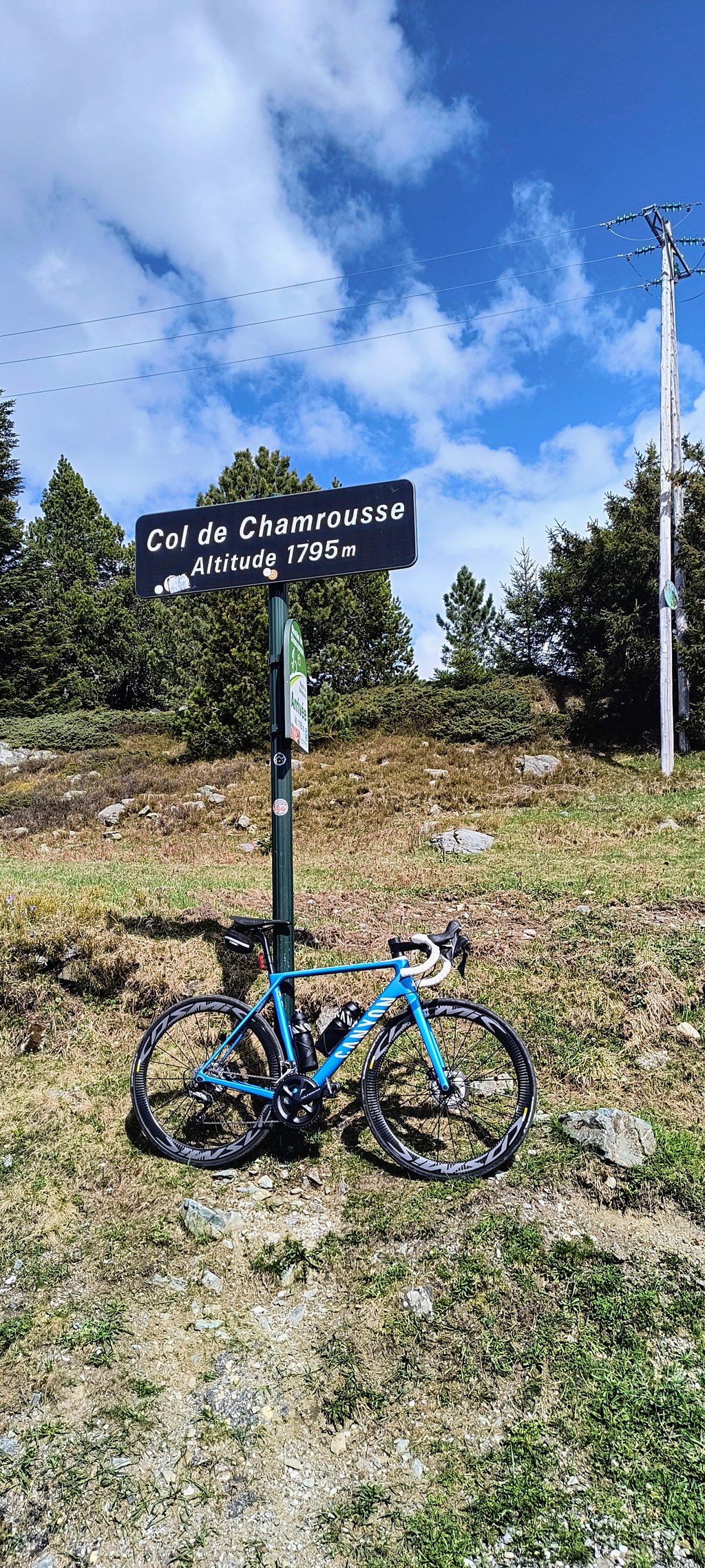
Chamrousse from Séchilienne is a climb in the region Grenoble. It is 11.4 mi long and bridges 4665 ft of vertical ascent with an average gradient of 7.7%, resulting in a difficulty score of 1376. The top of the ascent is located at 5869 ft above sea level. Climbfinder users shared 8 reviews of this climb and uploaded 11 photos.
Road names: C 1 & D 111
4.0 by Herve2023This is an automatic translation, the original language is: French.The climb is in two parts: - The first 9 km between Séchilienne are on a small communal road in the forest on gradients between 9 and 10 % with a few passages at 11 and 12%. There's not a moment's respite, but you can find a rhythm as the gradient is fairly even. The road, which is very quiet, is narrow and bumpy in places. It's best to avoid this road for the descent: prefer the descent along the D111, which is wide and in very good condition. - After a flat area and the C... read more

Welcome! Please activate your account if you would like to share something. Look for the verification email in your inbox.
If you want to upload your photos, you need to create an account. It only takes 1 minute and it's completely free.
This climb is in 2 stages: in the first stage you have to tackle the luitel, whose gradient is constantly above 9-10% and which is on a narrow road of average quality. After a short rest at the Lac du Luitel, we set off again for the end of the ascent to Chamrousse, on a fairly even slope and a wide, well-maintained road.
Cette montée se fait en 2 temps : dans un premier temps il faut affronter le luitel dont la pente est constamment au dessus des 9-10% et qui se fait sur une route étroite et de qualité moyenne. Après une courte récupération au lac du luitel, il faut repartir pour la fin de l'ascension de Chamrousse, sur une pente assez régulière et sur une route large et bien entretenue
A superb climb to Luitel: virtually no traffic, lots of shade and the gradients are just right. Then the climb to Chamrousse is easier, but with more traffic. I wouldn't recommend going back down the Luitel because the surface doesn't hinder you in the slightest on the way up, but on the way down it shakes you like a jackhammer!
Superbe montée jusqu'au Luitel : pratiquement pas de circulation, beaucoup d'ombre et les pourcentages sont au rendez-vous. Ensuite la montée vers Chamrousse est plus facile, et avec plus de circulation. Je conseille de ne pas redescendre par le Luitel car le revêtement ne gêne en rien à la montée mais en descente va vous secoue comme un marteau piqueur!
Not an easy climb, at least as far as the Col du Luitel, with little traffic and a clean road all the way, and a great view of the Col de la Morte when the forest becomes less dense.
Ascension vraiment pas facile au moins jusqu'au col du Luitel, peut de circulation et route nickel tout le long, une super vue sur le col de la Morte quand a foret se fait moins dense.
Nice climb, the first part up to the Col du Luitel is really worth doing for its authenticity even if the slope can be scary, the end is quieter as you pass on the wide Chamrousse road.
Belle montée, la première partie jusqu'au Col du Luitel est vraiment à faire pour son coté authentique même si la pente peut faire peur, la fin est plus tranquille car on passe sur la route large de Chamrousse.
The climb is in two parts:
- The first 9 km between Séchilienne are on a small communal road in the forest on gradients between 9 and 10 % with a few passages at 11 and 12%. There's not a moment's respite, but you can find a rhythm as the gradient is fairly even. The road, which is very quiet, is narrow and bumpy in places. It's best to avoid this road for the descent: prefer the descent along the D111, which is wide and in very good condition.
- After a flat area and the Col du Luitel, you join the D111, which leads up to the Chamrousse resort. The road is wide and the gradients vary between 5 and 7%, which makes the end of the climb easy and pleasant, especially as I passed very few vehicles (early August mid-morning).
L'ascension se décompose en deux parties :
- Les 9 premiers km entre Séchilienne se déroulent sur une petite route communale en forêt sur des pentes entre 9 et 10 % avec quelques passages à 11 et 12%. Il n'y a aucun moment de répit, mais on peut trouver un rythme car la pente est assez régulière. La route, très calme, est étroite et bosselée par endroits. Il vaut mieux éviter cette route pour la descente : préférez la descente par la D111 qui est large et en très bon état.
- Après un replat et le col du Luitel, on rejoint la D111 qui monte à la station de Chamrousse. La route est large et les pourcentages varient entre 5 et 7%, ce qui rend la fin de l'ascension facile et agréable, d'autant que j'ai croisé peu de véhicules (début août en milieu de matinée).
A long and difficult climb.
The first part up to the Col de Luitel is very quiet and well shaded (fortunately, it was hot), but the slope is steep and tiring.
The rest of the way is easier (if you have any strength left), on a wide road that is a little busy (but not too busy during the week).
I was happy to finish :)
To refuel, you have to go down the other side to the main station.
Une montée longue et difficile.
La première partie jusqu'au col de Luitel est très calme, bien ombragée (heureusement car c'était par temps chaud), mais la pente est sévère et usante.
La suite est plus facile (si il reste des forces), sur une route large et un peu fréquentée (sans excès en semaine)
J'étais content d'en terminer :)
Pour se ravitailler il faut descendre un peu de l'autre coté jusqu'à la station principale.
This is not a route that attracts cyclists because of its scenery (most of the time it is in the forest) or its viewpoints (few) but because it is the steepest climb in the Grenoble area, similar to the Croix de Fer, and at the same time one of the most difficult in the region.
From Séchilienne to the Col du Luitel, the road is steep, very narrow and often in very poor condition. From the col du Luitel to Chamrousse, the road is much wider (and busier), much less steep, and inevitably less picturesque.
Ce n'est pas une route qui attire le cycliste par ses paysages (on est la plupart du temps en forêt) ou ses points de vue (peu nombreux) mais par le fait qu'il s'agit de la montée à plus forte dénivellation dans les environs de Grenoble, du même ordre que la Croix de Fer, et en même temps une des plus grosses difficultés de la région.
De Séchilienne au col du Luitel, la route est raide, très étroite, et dans un état souvent très perfectible. Du col du Luitel à Chamrousse, la route est bien plus large (et plus fréquentée), nettement moins pentue, et forcément moins pittoresque.
| 5 mph | 02:17:48 |
| 7 mph | 01:37:33 |
| 9 mph | 01:16:01 |
| 12 mph | 00:57:07 |
This page is better in the app