Sustenpass is a climb in the region Bern. It is 27.6 km long and bridges 1597 m of vertical ascent with an average gradient of 5.8%, resulting in a difficulty score of 1072. The top of the ascent is located at 2222 m above sea level. Climbfinder users shared 15 reviews of this climb and uploaded 29 photos.
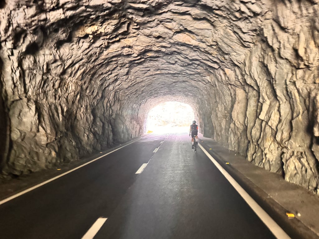
Beautiful climb, especially if you do it early or late season. There are some tunnels, so take your lights. The view down on the lake is amazing. It’s makes a great sweeping descent too.
This is an automatic translation, the original language is: Spanish.
Show original
A very long pass with a more bearable first part but at the end a little more complicated due to the time it takes to climb, the increase in gradient and the altitude. In any case, if you keep a calm pace, it is not so hard (knowing beforehand that it is a 28km climb).
It is important to stock up on water, because I only found one fountain on the whole climb.
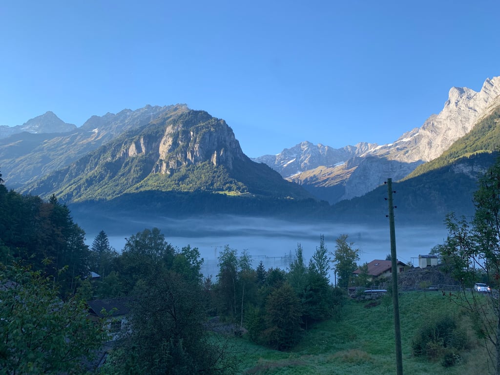
The asphalt is good and the views are spectacular. On the right throughout the climb you are distracted by the scenery and this makes you forget that you are pedalling.
As I say, on the right you can see a waterfall in the distance, but it is so big and loud that it seems to be right next to you, and all this is visible as you emerge from a pine forest.
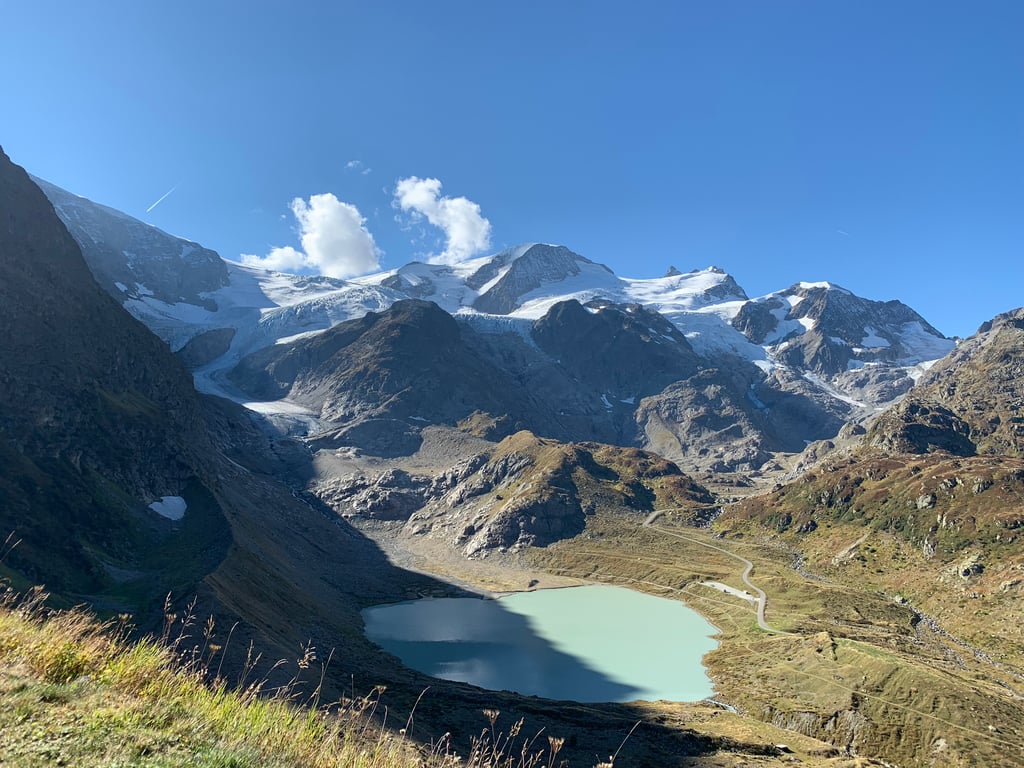
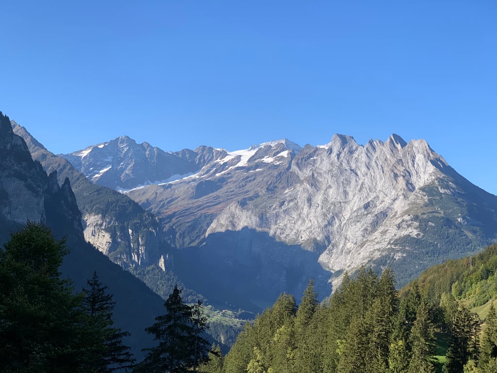
Further up, after stopping for two short stone tunnels through which another waterfall falls, you will see two glaciers, one of them with a waterfall that flows into a beautiful lake that you can also see during the ascent.
It would undoubtedly be a 5-star ascent, but it loses one due to the traffic, especially motorbikes.
The descent on the same side is also a pleasure.
Puerto muy largo con una primera parte más llevadera pero al final algo más complicado por el tiempo que se lleva subiendo, el aumento de la pendiente y la altitud. En cualquier caso, si se lleva un ritmo tranquilo, no se hace tan duro (sabiendo de ante mano que son 28km de subida).
Importante aprovisionarse de agua, porque solo encontré una fuente en toda la subida.
El asfalto es bueno y las vistas son espectaculares. A la derecha durante toda la subida te distrae el paisaje y eso hace que te olvides de que vas pedaleando.
Como digo, a la derecha se ve una cascada a lo lejos que sin embargo es tan grande y ruidosa que parece que la tienes al lado, y todo esto se ve según sales de un bosque de pinos.
Más arriba, tras parar por dos cortos túneles de piedra por los cuales cae otra cascada, se aprecian dos glaciares, uno de ellos con una cascada que desemboca en un precioso lago que también podemos observar durante el ascenso.
Sin duda sería un ascenso de 5 estrellas, pero pierde una por el tráfico, sobre todo de motos.
La bajada por el mismo lado también es un disfrute.
This is an automatic translation, the original language is: Dutch.
Show original
I can barely give this climb 5 stars. Why?
- Just too long with a not very interesting beginning
- There can be a lot of traffic, both (sports) cars's and motorbikes
- The pass height is an anti-climax: few views, a tunnel and an unpaved car park
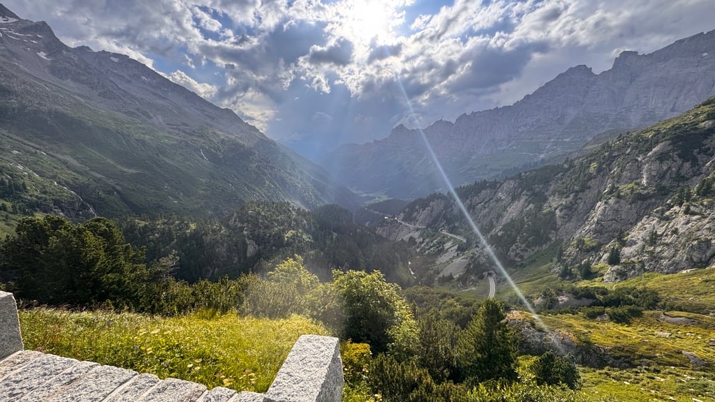
Still, this climb is worth a diversion, especially if the pass is still closed to vehicles as we had in mid-June 2024. At most, it's a bit of slalom around rocks, alpine marmots and snow, but that's no punishment. After Berghotel Steingletscher, you then have the excellent tarmac to yourself. Just after that, two hairpin bends below the pass height, you also have the best views. Otherwise, the gradient is fine.
If the pass does open to vehicles, I recommend leaving very early (sunrise) and on a weekday.
Ik kan deze klim net geen 5 sterren geven. Waarom?
- Net te lang met een niet bijster interessant begin
- Er kan heel veel verkeer zijn, zowel (sport)auto's als motoren
- De pashoogte is een anti-climax: weinig uitzicht, een tunnel en een onverharde parkeerplaats
Toch is deze klim een omweg waard, helemaal als de pas nog dicht is voor voertuigen zoals wij medio juni 2024 hadden. Het is hooguit een beetje slalommen om de stenen, alpenmarmotten en de sneeuw, maar dat is geen straf. Na Berghotel Steingletscher heb je dan het uitstekende asfalt voor jezelf. Vlak daarna, twee haarspeldbochten onder de pashoogte, heb je ook het mooiste uitzicht. Verder is het stijgingspercentage prima te doen.
Is de pas wel open voor voertuigen, dan raad ik aan zeer vroeg te vertrekken (zonsopkomst) en op een doordeweekse dag.
This is an automatic translation, the original language is: French.
Show original
27 kms of pure happiness! The difficulty is more in the length than in the rather uniform percentages. Varied landscapes including beautiful summits, notably the Titlis, several glaciers and some waterfalls. At the pass, don't hesitate to take the small road on the right to the restaurant (pies, sausages and cheese yum), and also to cross the tunnel to admire the valley and the peaks on the Uri side.
On the way down, take the time to stop and admire all the viewpoints.
27 kms de pur bonheur ! La difficulté est plus dans la longueur que dans les pourcentages assez uniformes. Paysages variés incluant de beaux sommets, notamment le Titlis, plusieurs glaciers et quelques cascades. Au col ne pas hésiter à prendre la petite route à droite jusqu'au restaurant (tartes, charcuteries et fromage miam), et aussi à traverser le tunnel pour admirer la vallée et les sommets côté Uri.
À la descente prendre le temps de s'arrêter pour admirer tous les points de vue
This is an automatic translation, the original language is: Dutch.
Show original
Really a beautiful climb. Ridden on a Friday morning in late July, the traffic was not too bad. The tarmac is mostly very good.
27,7 km is of course very long, especially if you do not want to stop on the way. It makes a difference that it never gets really steep and that heavier parts are often alternated with less heavy ones.
The last part is above 2000 metres. I had a tough time there!
Echt een prachtige beklimming. Gereden op een vrijdagochtend eind juli, het viel me heel erg mee qua verkeer. Het asfalt is overwegend erg goed.
27,7 km is natuurlijk wel erg lang, zeker als je onderweg niet wilt stoppen. Het scheelt dat het nergens echt heel steil wordt en dat zwaardere stukken vaak worden afgewisseld met minder zware stukken.
Het laatste deel fiets je boven de 2000 meter. Toen had ik het wel even zwaar!
This is an automatic translation, the original language is: Dutch.
Show original
End of September 2021. Bit similar to the Grimselpass something longer and higher. Many short tunnels (light)
But very beautiful. (A bad day) 80m below the top man with hammer. Eat and descend.
Eind September 2021. Beetje vergelijkbaar met de Grimselpass iets langer en hoger. Vele korte tunnels (lampje)
Maar heel mooi. (a bad day) 80m onder de top man met hamer. Bijkomen eten en afdalen.
This is an automatic translation, the original language is: Dutch.
Show original
A very nice environment, you can fully enjoy the beautiful nature. The top can sometimes be a bit misty so you better be extra careful. It can also be cold, but that is so on top of high mountains.
Een heel mooie omgeving, je kan volop genieten van de mooie natuur. De top kan soms wel wat mistig zijn waardoor je beter extra voorzichtig moet zijn. Het kan er ook koud zijn, maar dat is zo op de top van hoge bergen.
This is an automatic translation, the original language is: Dutch.
Show original
Difficult dilemma: continue to climb to the top, or take a trip to the glacier?
About 400 meters below the summit you can turn right (at a parking lot and mountain hotel) to a small but well paved road to the Steingletscher. That is also a small climb, but worth it if you are willing to park your bike and walk to the glacier.
About the climb: beautiful! There can be quite some traffic. The descent I descended with a huge smile and lasted for m'n feeling very long.
Moeilijk dilemma: doorklimmen tot aan de top, of toch even een uitstapje naar de gletsjer?
Zo'n 400 hoogtemeters onder de top kun je (bij een parkeerplaats en berghotel) naar rechts afslaan om via een klein maar goed geasfalteerd weggetje naar de Steingletscher te fietsen. Ook dat is nog een klein klimmetje, maar zeker de moeite waard als je bereid bent ook even je fiets te parkeren en naar de gletsjer te lopen.
Over de klim: prachtig! Er kan wel redelijk wat verkeer zijn. De afdaling ben ik met een enorme glimlach afgedaald en duurde voor m'n gevoel enorm lang.
This is an automatic translation, the original language is: Dutch.
Show original
Beautiful climb.
Although you're on the road a while and it takes a while.
Gravity is to the last 10 km's.
However, the view is the last km's more than worth it.
That is really enjoy.
There are some cars passing by with moments.
But there is a good tarmac and the track in very wide.
So if there is traffic, they certainly do not hinder you.
Also convenient is that you can enjoy a drink at the restaurant at the top.
Prachtige klim.
Al ben je wel even onderweg en duurt het dus wel even.
Zwaartepunt ligt naar de laatste 10 km's.
Echter is het uitzicht de laatste km's meer dan de moeite waard.
Dat is echt genieten.
Er passeren wel wat auto's met momenten.
Maar er ligt een goed asfalt en de baan in zeer breed.
Dus als er verkeer is, hinderen ze u zeker niet.
Ook handig is dat je bovenaan kan genieten van wat drinken bij het restaurant op de top.
This is an automatic translation, the original language is: Dutch.
Show original
From Innertkirchen it takes quite a while before you reach the 'last' village of Gadmen, but that village takes longer than you expect; the triftbahn is the start, but only at the camping it's over and the 'real' work begins! It all turns and turns nicely. After Steingletscher come the real pictures: the whole climb is worth the view for the last 3/4 kilometer alone.
Vanuit Innertkirchen duurt het aardig lang voor je bij het ‘laatste’ dorp Gadmen bent, maar dat dorp duurt langer dan je verwacht; de triftbahn is het begin, maar pas bij de camping is het voorbij en begint het ‘echte’ werk! Het keert en draait allemaal lekker. Na Steingletscher komen de echt plaatjes: de hele klim is het uitzicht de laatste 3/4 kilometer alleen al waard.
This is an automatic translation, the original language is: Dutch.
Show original
You start enthusiastically in Innertkirchen, and when you get to Gadmen you realize that you're still nowhere and you're already in a good piece. A beautiful climb, but very heavy.
Je begint enthousiast in Innertkirchen, en als je dan bij Gadmen bent, besef je je dat je nog eigenlijk helemaal nergens bent en je toch al wel aardig stuk zit. Een prachtige klim, maar erg zwaar.
This is an automatic translation, the original language is: Dutch.
Show original
Excellent climb with good road surface, when we were there it was not busy, on the week before the summer holidays. The pass was just one week open because of the snow that was still there.
Prima klim met goed wegdek, toen wij er waren was het er niet druk, door de weeks voor de zomer vakantie. De pas was net een week open vanwege de sneeuw die er nog lag..
This is an automatic translation, the original language is: Dutch.
Show original
In the beginning you think this is good to do but the last 10 km are heavy but super nice with views of a beautiful glacier. it is cold upstairs
In het begin denk je deze is goed te doen maar de laatste 10 km zijn zwaar maar wel super mooi met uitzicht op een mooie gletscher. het wordt boven wel koud
You don't need special gearing for Sustenpass. The slope isn't long or steep enough to require much shifting down. You can conquer this climb on power alone. However, a compact gearing system with a smallest front chainring of 34 and largest rear sprocket of 28 or 30 is always nice if you enjoy cycling uphill. This helps maintain a smooth cadence.
Sustenpass belongs to the Hors Catégorie, the top category. These are legendary and very tough climbs. A solid cycling condition, experience, and a good climbing gear ratio are essential to maintain a smooth cadence and complete the climb comfortably.
Sustenpass is 27.6 km long.
The average gradient of Sustenpass is 5.8%.
Sustenpass has a steepest segment with an average gradient of 9.3%.
The summit of Sustenpass is at 2222 m.
At a slow pace of 7 km/h, it takes about 03:56:33 to climb Sustenpass. At 11 km/h the time is 02:30:32, and at 15 km/h 01:50:23. For the fastest cyclists, 01:27:09 is an achievable time.