View on map
© MapLibre | OpenStreetMap contributors
1%
2%
4%
6%
8%
10%
12%
15%
20%

Col de Péguère / Mur de Péguère

4.3
3 reviews | Elevation profile | 2 photos
Tips nearby
Col de Péguère / Mur de Péguère
transparant thumb
transparant thumb
transparant thumb
transparant thumb
transparant thumb
transparant thumb
Your achievable time
Calculating based on your best performances...
Relaxed
Maximum
W/kg
W/kg
W/kg
Analyse your climbing performance
Detailed insight into your climbing performance & automatically check off climbs
Based on your best performances.
Your best attempt:
Number of attempts:
Elevation profile Col de Péguère / Mur de Péguère

Statistics

Difficulty points 746
Length 9.4 km
Average gradient 8%
Steepest 100 metres 17.6%
Total ascent 747 m

Short recap

Beautiful scenery
6 hairpin turns
#56 toughest climb of Occitania
#30 most elevation gain of Ariège
#45 longest climb of Ariège
#52 average steepest climb of Ariège
Feedback about this climb?
Show climbs nearby Export to GPS device

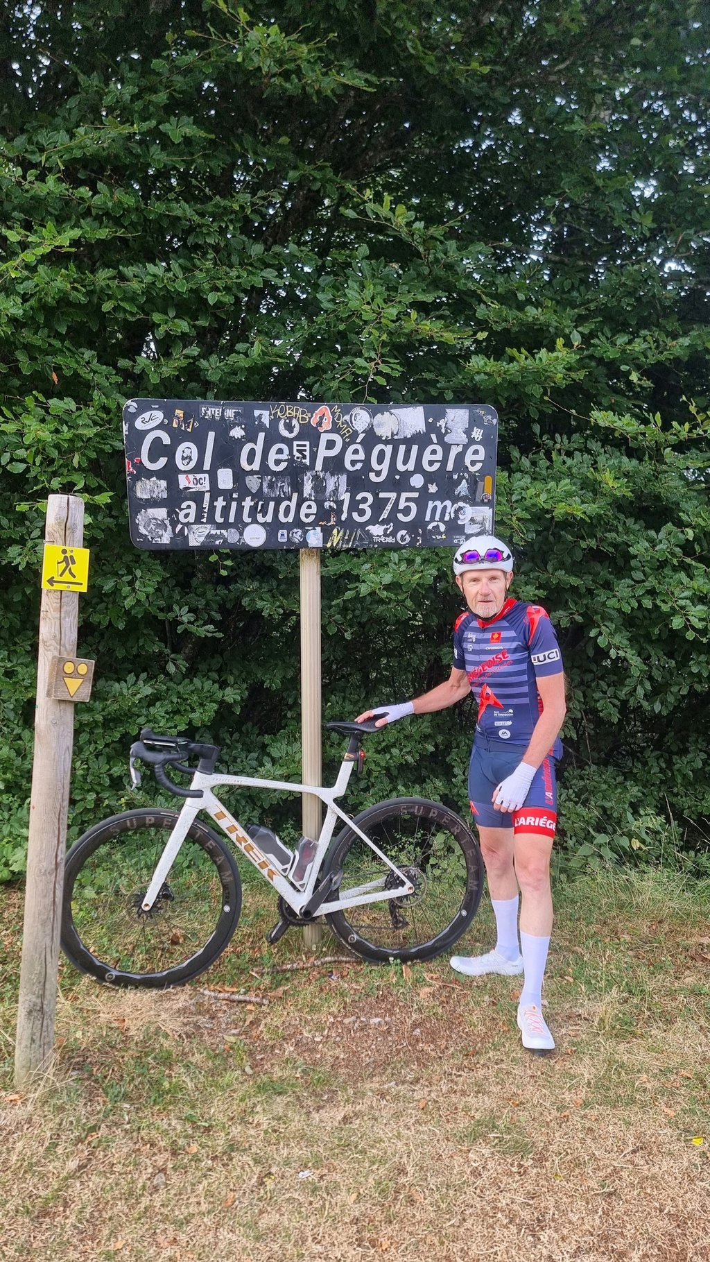
Col de Péguère / Mur de Péguère is a climb in the region Ariège. It is 9.4 km long and bridges 747 m of vertical ascent with an average gradient of 8%, resulting in a difficulty score of 746. The top of the ascent is located at 1374 m above sea level. Climbfinder users shared 3 reviews of this climb and uploaded 2 photos.

Road name: D618

4.0 by -flo
This is an automatic translation, the original language is: French.
The first part was easy enough to warm up... The section from the Col des Caougnous to the Col de Péguère is nothing but bliss.... (it's hell!!!) 1st km at 18%. Beautiful view from the top. Very nice to do.... read more

Photos (2)

Col de Péguère / Mur de Péguère
transparant thumb
transparant thumb
transparant thumb
transparant thumb

Your uploads (max 4)

Welcome! Please activate your account if you would like to share something. Look for the verification email in your inbox.

If you want to upload your photos, you need to create an account. It only takes 1 minute and it's completely free.

  • Receive free climbfinder goodies for your reviews & photos.
  • Create a bucket list and check off conquered climbs.
  • Add missing climbs.
Continue with GoogleContinue with Google Continue with FacebookContinue with Facebook Continue with AppleContinue with Apple Sign up with email
By signing up you agree to our terms of service and confirm that you have read our privacy & content policy.

Reviews (3)

5.0
4.0
3.0
2.0
1.0
pierre81
6 d 5.0
This is an automatic translation, the original language is: French. Show original

I climbed this pass in sweltering heat, which is surely skewing my perception, but I think it’s one of the toughest passes I’ve ever climbed! The first section, which is shared with the Col de Portel, serves as a warm-up: a wide road in excellent condition, not too much traffic, and gradients that never exceed 6 per cent... Then comes the junction and the left-hand bend leading to “the wall”. You’re immediately thrown into the thick of it: a sign reading “Caution: 18 per cent gradient” awaits you, and the sign marking the start of the pass indicates an average gradient of around 12 per cent… The climb is in the shade, but you won’t have time to enjoy the scenery – the gradient is too steep. This is a climb that should definitely not be underestimated and will really make your thighs ache!

Col grimpé sous forte chaleur qui biaise sûrement mon ressenti, mais je crois qu'il s'agit de l'un des cols les plus durs que j'ai grimpé ! La première partie, commune au col de Portel, sert d'échauffement : route large et en excellent état, pas trop de circulation, des pourcentages qui ne dépassent jamais les 6%... Puis vient l'intersection et le virage à gauche pour rejoindre "le mur". Vous êtes immédiatement mis dans l'ambiance : un panneau "attention pente 18%" vous attend, et le panneau de départ du col indique une moyenne proche des 12%... La montée est à l'ombre, en revanche vous n'aurez pas le temps de profiter des paysages, la pente est trop raide. Une montée qu'il ne faut surtout pas sous-estimer et qui vous fera bien mal aux cuisses !

Dashboard
-flo
1 y 4.0
This is an automatic translation, the original language is: French. Show original

The first part was easy enough to warm up... The section from the Col des Caougnous to the Col de Péguère is nothing but bliss.... (it's hell!!!) 1st km at 18%. Beautiful view from the top. Very nice to do.

Première partie sans difficulté pour se chauffer car... La partie du col des Caougnous au col de Péguère que du bonheur... (c'est l'enfer!!!) 1er km à 18%. Très belle vue en haut. A faire très sympa.

Dashboard
Sugar_Pepette
1 y 4.0
This is an automatic translation, the original language is: French. Show original

Extremely steep pass on a narrow road at the end.

Col extrêmement raide sur route étroite à la fin.

Dashboard

Climbing times

7 km/h 01:20:30
11 km/h 00:51:13
15 km/h 00:37:34
19 km/h 00:29:39

Road surface condition

56% 44% 0%
Based on 9 votes
Share your knowledge. What was the road condition during your ascent?

Traffic

89% 11% 0%
Based on 9 votes
Your experience counts. How much traffic did you encounter during the climb?

Frequently Asked Questions

Col de Péguère / Mur de Péguère can be cycled from 3 sides. Col de Péguère / Mur de Péguère from Massat is the most popular side, but the summit can also be reached via Col de Péguère from La Mouline / Serres sur Arget & Col de Péguère from Estaniels.

Col de Péguère / Mur de Péguère is a challenging ascent. For this type of climbing, we recommend mountain gearing, specifically a compact system. This means a small front chainring of 34 teeth, combined with a rear cassette where, depending on your level, strength, and experience, you choose a sprocket with 30, 32, or even 34 teeth. Remember that a smooth cadence is always more efficient!

Col de Péguère / Mur de Péguère is a first-category climb: long and tough. Do not underestimate this climb. Many famous Tour de France cols fall into this category. Prepare for a long, challenging ride. Only well-trained riders will reach the top smoothly. Make sure you have a road bike with climbing gears and enough training; otherwise, it will be a struggle.

Col de Péguère / Mur de Péguère is 9.4 km long.

The average gradient of Col de Péguère / Mur de Péguère is 8%.

Col de Péguère / Mur de Péguère has a steepest segment with an average gradient of 17.6%.

The summit of Col de Péguère / Mur de Péguère is at 1374 m.

At a slow pace of 7 km/h, it takes about 01:20:30 to climb Col de Péguère / Mur de Péguère. At 11 km/h the time is 00:51:13, and at 15 km/h 00:37:34. For the fastest cyclists, 00:29:39 is an achievable time.

Col de Péguère / Mur de Péguère is located in the region Ariège in France.

This page is better in the app

Climbfinder app
Climbfinder
(Free)
Open