Monte Tovo from Isolella is a climb in the region Vercelli. It is 10 km long and bridges 835 m of vertical ascent with an average gradient of 8.4%, resulting in a difficulty score of 867. The top of the ascent is located at 1193 m above sea level. Climbfinder users shared 3 reviews of this climb and uploaded 5 photos.
This is an automatic translation, the original language is: Italian.
The ascent to Monte Tovo (at the end of the asphalt road to the dirt square and the small votive shrine with a fine view of lower Valsesia) offers two slopes: this is the longer and more discontinuous one, which, compared with the one that climbs up from Doccio, offers some fine walls with gradients approaching 20% and long stretches that settle between 12 and 13% and occasionally 15-16-17%. The difference with the northern slope is that the one that climbs from Isolella offers 4 km that ...read more
Photos (5)
Welcome! Please activate your account if you would like to share something. Look for the verification email in your inbox.
This is an automatic translation, the original language is: Italian.
Show original
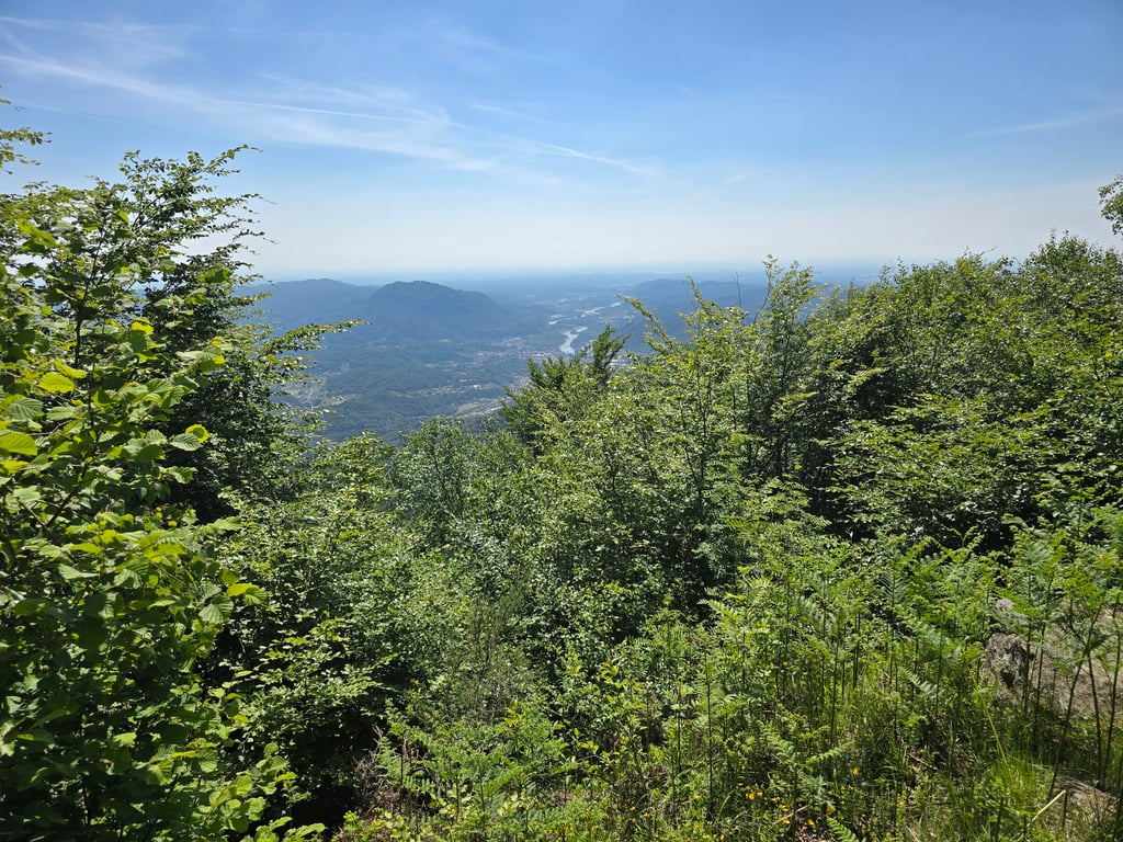
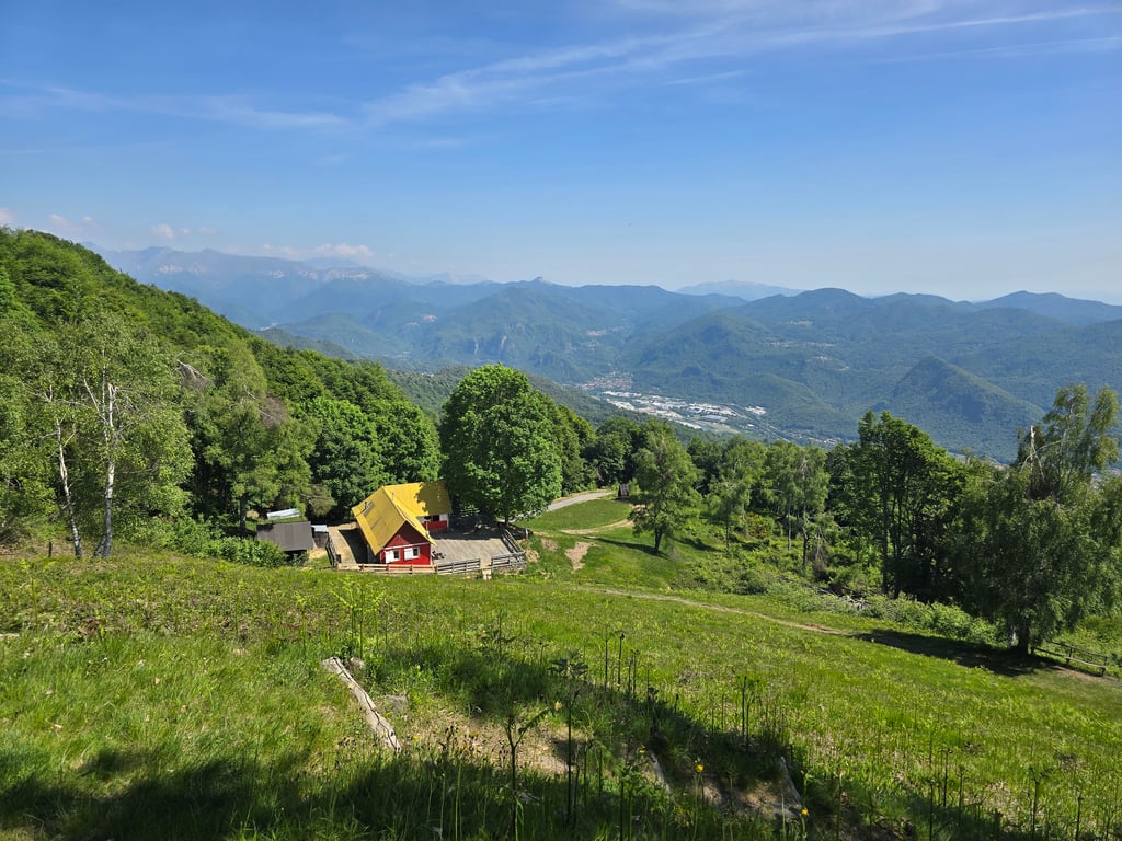
The ascent to Monte Tovo (at the end of the asphalt road to the dirt square and the small votive shrine with a fine view of lower Valsesia) offers two slopes: this is the longer and more discontinuous one, which, compared with the one that climbs up from Doccio, offers some fine walls with gradients approaching 20% and long stretches that settle between 12 and 13% and occasionally 15-16-17%. The difference with the northern slope is that the one that climbs from Isolella offers 4 km that are easy with gradients that settle between 5 and 7%. The remaining 6, after the village of Costa di Foresto, become particularly difficult due to the very narrow roadway and a mild gradient close to 11%. Unfortunately, the southern slope is also exposed to the sun for long stretches, so tackling it in high temperatures becomes extremely difficult. The section between the right-hand and left-hand hairpin bends before the drinking fountain located just before the Rifugio Gillodi (now dry - it no longer dispenses water) at 1050 m asl is the toughest: 250m with gradients that settle at 16-17% which is right at the end of the hard section in the middle. In the vicinity of the Rifugio the gradient allows you to take a breather for a moment and then face a wall again, at the top of which is the junction with the road up from Doccio. The last kilometre should not be underestimated: it still has gradients of over 10% and with your strength at its lowest, the risk of getting stuck is high. At the summit the view is not bad, but the best is the one on the stretch of road above the Gillodi refuge. For refuelling with water, the only possibility is at Costa di Foresto, just before the start of the hard section. This is a climb that should only be tackled if you are well-trained and have a bike with suitable gear ratios.
L'ascesa al Monte Tovo (al termine dell'asfalto al piazzale sterrato e alla piccola edicola votiva con bella vista sulla bassa Valsesia) offre 2 versanti: questo è quello più lungo e discontinuo, che offre rispetto a quello che sale da Doccio, dei bei muri con pendenze che sfiorano il 20% e lunghi tratti che si assestano tra il 12 e il 13% e occasionalmente 15-16-17%. La differenza rispetto al versante Nord e che quello che sale da Isolella offre 4 km tutto sommato facili con pendenze che si assestano tra il 5 e il 7%. I restanti 6, dopo l'abitato di Costa di Foresto, diventano particolarmente ostici per la sede stradale strettissima e una pendenza mendia prossima all'11%. Purtroppo il versante sud è pure esposto per lunghi tratti al sole e pertanto affrontarla con temperature alte diventa oltremodo dura. Il tratto tra il tornante destrorso e quello sinistrorso prima della fontanella posta poco prima del Rifugio Gillodi (ormai secca - non eroga più acqua) a 1050 m slm è il più ostico: 250m con pendenze che si assestano al 16-17% che sono proprio al termine del tratto duro della parte centrale. In prossimità del Rifugio la pendenza permette di rifiatare un attimo per poi affrontare nuovamente un muro alla cui sommità è presente l'incrocio con la strada che sale da Doccio. L'ultimo km non va sottovalutato: prensenta ancora pendenze over 10% e con le forze al lumicino il rischio di piantarsi è alto. Alla sommità la vista non è male, ma la migliore è quella nel tratto di strada posta sopra il rifugio Gillodi. Per il rifornimento d'acqua l'unica possibilità e a Costa di Foresto, poco prima dell'inizio del tratto duro. E' una salita da affrontare solo se allenati e con bici con adeguati rapporti.
This is an automatic translation, the original language is: Italian.
Show original
Lovely climb through the forest, divided into two parts, first part a wide, rideable road, second part winding through the forest on a narrow road.
If you are thirsty, the fountain is about 700/800m from the summit
Bella salita nel bosco, divisa in due parti, prima parte strada larga e pedalabile, seconda parte che si impenna tra il bosco su strada stretta.
Se si ha sete la fontana è circa 700/800m dello scollinamento
This is an automatic translation, the original language is: Italian.
Show original
A beautiful variant to climb up to Tovo, which is in no way inferior to the other, with which it joins just before the finish. This one is less continuous but has a couple of decidedly steeper climbs than the other. However, it is just as beautiful.
Bella variante per salire al Tovo, che non ha nulla da invidiare all'altra con cui si congiunge poco prima dell'arrivo. Questa è meno continua ma ha un paio di strappi decisamente più ripidi dell'altra. Comunque altrettanto bella.
Monte Tovo from Isolella is a challenging ascent. For this type of climbing, we recommend mountain gearing, specifically a compact system. This means a small front chainring of 34 teeth, combined with a rear cassette where, depending on your level, strength, and experience, you choose a sprocket with 30, 32, or even 34 teeth. Remember that a smooth cadence is always more efficient!
Monte Tovo from Isolella is a first-category climb: long and tough. Do not underestimate this climb. Many famous Tour de France cols fall into this category. Prepare for a long, challenging ride. Only well-trained riders will reach the top smoothly. Make sure you have a road bike with climbing gears and enough training; otherwise, it will be a struggle.
Monte Tovo from Isolella is 10 km long.
The average gradient of Monte Tovo from Isolella is 8.4%.
Monte Tovo from Isolella has a steepest segment with an average gradient of 20.8%.
The summit of Monte Tovo from Isolella is at 1193 m.
At a slow pace of 7 km/h, it takes about 01:25:18 to climb Monte Tovo from Isolella. At 11 km/h the time is 00:54:17, and at 15 km/h 00:39:48. For the fastest cyclists, 00:31:25 is an achievable time.
Monte Tovo from Isolella is located in the region Vercelli in Italy.