View on map
© MapLibre | OpenStreetMap contributors
1%
2%
4%
6%
8%
10%
12%
15%
20%

Montchaffrey from Vaulnaveys le Haut

3.0
2 reviews | Elevation profile | 2 photos
Tips nearby
Montchaffrey from Vaulnaveys le Haut
transparant thumb
transparant thumb
transparant thumb
transparant thumb
transparant thumb
transparant thumb
Your achievable time
Calculating based on your best performances...
Relaxed
Maximum
W/kg
W/kg
W/kg
Analyse your climbing performance
Detailed insight into your climbing performance & automatically check off climbs
Based on your best performances.
Your best attempt:
Number of attempts:
Elevation profile Montchaffrey from Vaulnaveys le Haut

Statistics

Difficulty points 515
Length 8.1 km
Average gradient 7%
Steepest 100 metres 14.2%
Total ascent 564 m

Short recap

6 hairpin turns
#96 toughest climb of Grenoble
#90 most elevation gain of Grenoble
#93 longest climb of Grenoble
Feedback about this climb?
Show climbs nearby Export to GPS device

Montchaffrey from Vaulnaveys le Haut is a climb in the region Grenoble. It is 8.1 km long and bridges 564 m of vertical ascent with an average gradient of 7%, resulting in a difficulty score of 515. The top of the ascent is located at 896 m above sea level. Climbfinder users shared 2 reviews of this climb and uploaded 2 photos.

Road name: D11

This is an automatic translation, the original language is: French.
I see that the statistic for the steepest 100m of the climb has been corrected since my previous comment. In fact, the 14.2% that are shown now are much more likely! :-)... read more

Photos (2)

Montchaffrey from Vaulnaveys le Haut
transparant thumb
transparant thumb
transparant thumb
transparant thumb

Your uploads (max 4)

Welcome! Please activate your account if you would like to share something. Look for the verification email in your inbox.

If you want to upload your photos, you need to create an account. It only takes 1 minute and it's completely free.

  • Receive free climbfinder goodies for your reviews & photos.
  • Create a bucket list and check off conquered climbs.
  • Add missing climbs.
Continue with GoogleContinue with Google Continue with FacebookContinue with Facebook Continue with AppleContinue with Apple Sign up with email
By signing up you agree to our terms of service and confirm that you have read our privacy & content policy.

Reviews (2)

5.0
4.0
3.0
2.0
1.0
Franck_Pastor
6 Mo 3.0
This is an automatic translation, the original language is: French. Show original

I see that the statistic for the steepest 100m of the climb has been corrected since my previous comment. In fact, the 14.2% that are shown now are much more likely! :-)

Je vois que la statistique des 100 m les plus raides de l'ascension a été rectifiée depuis mon précédent commentaire. De fait, les 14,2% qui sont indiqués maintenant sont beaucoup plus réalistes ! :-)

Dashboard
Franck_Pastor
7 Mo 3.0
This is an automatic translation, the original language is: French. Show original

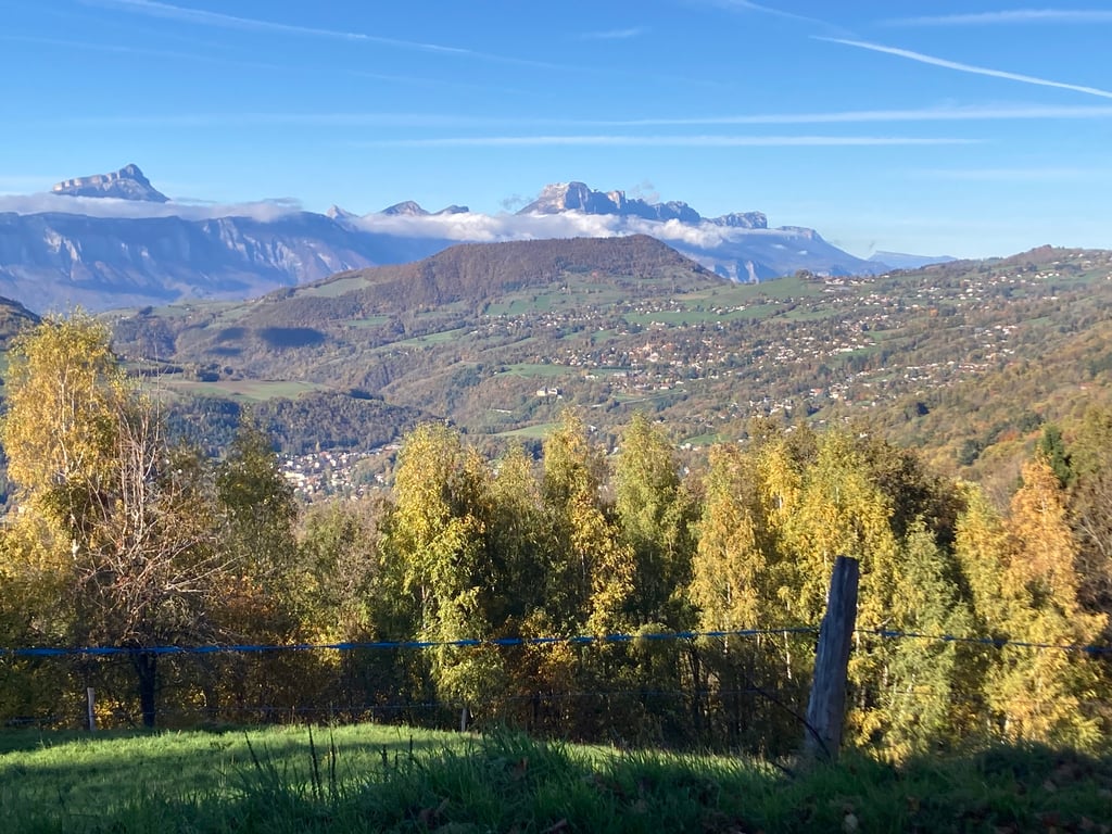
The first two kilometres are the ascent to Chamrousse. Then, just outside Belmont, you turn right for a short descent (with fine views) followed by a fairly narrow but good road that climbs steeply, mostly through the forest.

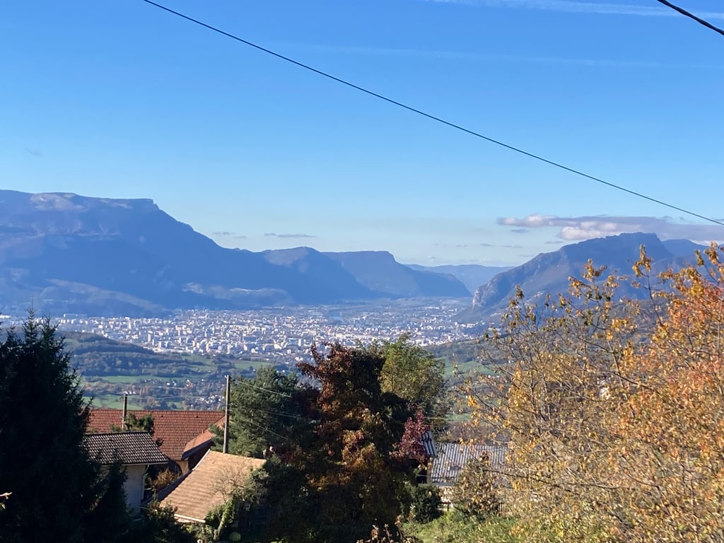
Beautiful views of Grenoble, the Voreppe valley, the Chartreuse and the Vercors from the hamlet of Montchaffrey, at the end of the slope.

It's worth noting that while the gradient is indeed generally steep, I couldn't find any trace of the 19.8 % per 100 m recorded on the profile.

Les deux premiers kilomètres sont ceux de la montée de Chamrousse. Puis vers la sortie de Belmont, on tourne à droite pour emprunter une brève descente (beau point de vue) suivie d'une route assez étroite mais en bon état, qui monte sérieusement, la plupart du temps en pleine forêt.

Beaux points de vue sur Grenoble, la cluse de Voreppe, la Chartreuse et le Vercors au hameau de Montchaffrey, terme de la côte.

À noter que si la pente est en effet globalement élevée, je n'ai pas trouvé trace des 19,8 % sur 100 m relevés sur le profil.

Dashboard

Climbing times

7 km/h 01:09:23
11 km/h 00:44:09
15 km/h 00:32:23
19 km/h 00:25:33

Road surface condition

100% 0% 0%
Based on 2 votes
Share your knowledge. What was the road condition during your ascent?

Traffic

100% 0% 0%
Based on 2 votes
Your experience counts. How much traffic did you encounter during the climb?

Frequently Asked Questions

Montchaffrey from Vaulnaveys le Haut is a challenging ascent. For this type of climbing, we recommend mountain gearing, specifically a compact system. This means a small front chainring of 34 teeth, combined with a rear cassette where, depending on your level, strength, and experience, you choose a sprocket with 30, 32, or even 34 teeth. Remember that a smooth cadence is always more efficient!

Montchaffrey from Vaulnaveys le Haut is a serious climb and falls into the 2nd category. With a good basic fitness level, even without much cycling experience, you can complete this climb just fine. However, a bike with climbing gears is a must. Without experience or training, it will be really tough – but that’s part of the challenge!

Montchaffrey from Vaulnaveys le Haut is 8.1 km long.

The average gradient of Montchaffrey from Vaulnaveys le Haut is 7%.

Montchaffrey from Vaulnaveys le Haut has a steepest segment with an average gradient of 14.2%.

The summit of Montchaffrey from Vaulnaveys le Haut is at 896 m.

At a slow pace of 7 km/h, it takes about 01:09:23 to climb Montchaffrey from Vaulnaveys le Haut. At 11 km/h the time is 00:44:09, and at 15 km/h 00:32:23. For the fastest cyclists, 00:25:33 is an achievable time.

Montchaffrey from Vaulnaveys le Haut is located in the region Isère in France.

This page is better in the app

Climbfinder app
Climbfinder
(Free)
Open