Tips nearby


| 14 hairpin turns |
| #13 toughest climb of Haute Savoie |
| #7 most elevation gain of Haute Savoie |
| #14 longest climb of Haute Savoie |
Col de Cenise - Les Frachets from Marnaz is a climb in the region Haute Savoie. It is 15.2 km long and bridges 1065 m of vertical ascent with an average gradient of 7%, resulting in a difficulty score of 878. The top of the ascent is located at 1567 m above sea level. Climbfinder users shared 1 review/story of this climb and uploaded 2 photos.
Road names: Route de Cluses & Route de Morsullaz
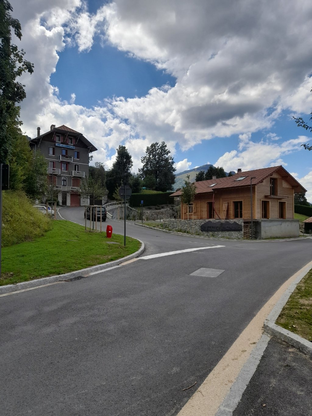
2.0 by Herve2023This is an automatic translation, the original language is: French.Please note: the first part of the ascent to Mont Saxonnex is on a very good, wide, even road (often in the shade). At Mont Saxonnex, if you continue on the main road, you will go to the Col de Solaison (on 30 July, this road was under construction and closed). To get to the Col de Cenise, turn left (if you are coming from Scionzier-Marnaz; right if you are coming from Thuez) onto a small road that is not very easy to spot (route de Morsullaz) at the level of a small chalet "espace montagne... read more
Welcome! Please activate your account if you would like to share something. Look for the verification email in your inbox.
If you want to upload your photos, you need to create an account. It only takes 1 minute and it's completely free.
Please note: the first part of the ascent to Mont Saxonnex is on a very good, wide, even road (often in the shade). At Mont Saxonnex, if you continue on the main road, you will go to the Col de Solaison (on 30 July, this road was under construction and closed). To get to the Col de Cenise, turn left (if you are coming from Scionzier-Marnaz; right if you are coming from Thuez) onto a small road that is not very easy to spot (route de Morsullaz) at the level of a small chalet "espace montagne and a building "OTE de la GORGE du CE". See photo.
From this point onwards, the road is narrow and rough and not very pleasant for a road bike. You'll come across a few cars, as there's an activity park halfway up and the Auberge des Frachets, which is on the pass, attracts quite a crowd and is a crossroads for hikers.
Be careful when descending the 8km of this section (especially the upper 4km).
To sum up: on a road bike, the section after Mont Saxonnex is not at all pleasant and is of no sporting interest other than to complete a fairly long climb.
Attention : la première partie de l'ascension jusqu'à Mont Saxonnex s'effectue sur très bonne route large et régulière (souvent à l'ombre). A Mont Saxonnex, si vous continuez sur la route principale, vous irez au col de Solaison (le 30 juillet, cette route était en travaux et barrée). Pour aller au col de Cenise, il faut prendre à gauche (quand vous venez de Scionzier-Marnaz; à droite si vous venez de Thuez), une petite route peu évidente à repérer (route de Morsullaz) à hauteur d'un petit chalet "espace montagne et d'un bâtiment "OTE de la GORGE du CE". Cf photo.
A partir de là, la route est étroite et dégradée et peu agréable à monter avec un vélo de route. Vous croiserez quelques automobiles puisqu'à mi-chemin se trouve un parc d'activités et que l'auberge des Frachets, qui se trouve au col, attire son petit monde et constitue un carrefour pour les randonneurs.
Méfiance pour descendre les 8km de ce tronçon (surtout les 4 km supérieurs).
En résumé : avec un vélo de route, la partie après mont Saxonnex n'est vraiment pas agréable et n'a aucun intérêt sportif autre que de boucler une assez longue montée.
| 7 km/h | 02:09:52 |
| 11 km/h | 01:22:39 |
| 15 km/h | 01:00:36 |
| 19 km/h | 00:47:51 |
This page is better in the app