View on map
© MapLibre | OpenStreetMap contributors
1%
2%
4%
6%
8%
10%
12%
15%
20%

Le Bochet from Villargondren

2.5
2 reviews | Elevation profile | 3 photos
Tips nearby
Le Bochet from Villargondren
transparant thumb
transparant thumb
transparant thumb
transparant thumb
transparant thumb
Your achievable time
Calculating based on your best performances...
Relaxed
Maximum
W/kg
W/kg
W/kg
Analyse your climbing performance
Detailed insight into your climbing performance & automatically check off climbs
Based on your best performances.
Your best attempt:
Number of attempts:
Elevation profile Le Bochet from Villargondren

Statistics

Difficulty points 98
Length 2.3 km
Average gradient 5.6%
Steepest 100 metres 11.2%
Total ascent 126 m
Feedback about this climb?
Show climbs nearby Export to GPS device

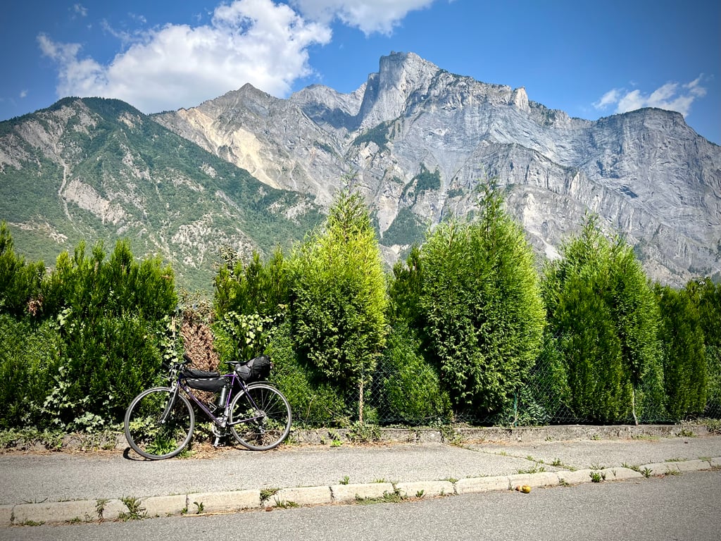
Le Bochet from Villargondren is a climb in the region La Maurienne. It is 2.3 km long and bridges 126 m of vertical ascent with an average gradient of 5.6%, resulting in a difficulty score of 98. The top of the ascent is located at 699 m above sea level. Climbfinder users shared 2 reviews of this climb and uploaded 3 photos.

Road names: Route des Anciennes Resses (D 81) & Rue des Sauges

2.0 by Cromagnon
This is an automatic translation, the original language is: French.
It's so short! We're not used to getting to the finish so quickly here. It's a steep climb for just 700 metres. We're not used to that either! A little recreation in the midst of the big, nasty passes and lesser-known climbs that still hurt. This climb allows you to avoid the busy road below. Otherwise, it won't leave any lasting impression.... read more

Photos (3)

Le Bochet from Villargondren
transparant thumb
transparant thumb
transparant thumb

Your uploads (max 4)

Welcome! Please activate your account if you would like to share something. Look for the verification email in your inbox.

If you want to upload your photos, you need to create an account. It only takes 1 minute and it's completely free.

  • Receive free climbfinder goodies for your reviews & photos.
  • Create a bucket list and check off conquered climbs.
  • Add missing climbs.
Continue with GoogleContinue with Google Continue with FacebookContinue with Facebook Continue with AppleContinue with Apple Sign up with email
By signing up you agree to our terms of service and confirm that you have read our privacy & content policy.

Reviews (2)

5.0
4.0
3.0
2.0
1.0
Cromagnon
9 Mo 2.0
This is an automatic translation, the original language is: French. Show original

It's so short! We're not used to getting to the finish so quickly here. It's a steep climb for just 700 metres. We're not used to that either! A little recreation in the midst of the big, nasty passes and lesser-known climbs that still hurt. This climb allows you to avoid the busy road below. Otherwise, it won't leave any lasting impression.

C’est si court ! Ici, on n’a pas l’habitude d’arriver si vite au but. Ça grimpe bien pendant seulement 700 mètres. De ça non plus, on n’a plus l’habitude ! Une petite récréation au milieu des grands cols méchants et des montées moins connues qui font tout de même mal. Cette côte permet d’éviter la route du bas très fréquentée. Sinon, elle ne laissera aucun souvenir.

Le Bochet from Villargondren
Dashboard
WouterDK
11 Mo 3.0
This is an automatic translation, the original language is: Dutch. Show original

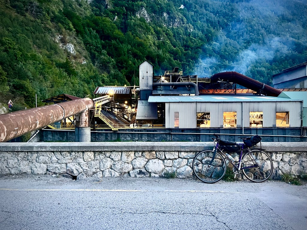
Short climb for this area that comes in two sections. The road winds up and down against the forested mountainside. Nice alternative to the main road lower down the valley. At the roundabout before the village you have a water fountain.

Korte klim voor deze omgeving die in twee stukken komt. De weg kronkelt op en neer tegen de beboste bergflank. Leuk alternatief voor de grote weg die lager door de vallei loopt. Op de rotonde voor het dorpje heb je een waterfonteintje.

Dashboard

Climbing times

7 km/h 00:19:22
11 km/h 00:12:19
15 km/h 00:09:02
19 km/h 00:07:08

Road surface condition

100% 0% 0%
Based on 1 vote
Share your knowledge. What was the road condition during your ascent?

Traffic

100% 0% 0%
Based on 1 vote
Your experience counts. How much traffic did you encounter during the climb?

Frequently Asked Questions

You don't need special gearing for Le Bochet from Villargondren. The slope isn't long or steep enough to require much shifting down. You can conquer this climb on power alone. However, a compact gearing system with a smallest front chainring of 34 and largest rear sprocket of 28 or 30 is always nice if you enjoy cycling uphill. This helps maintain a smooth cadence.

Le Bochet from Villargondren is a 4th-category climb. A sprint to the top is usually not an option, and untrained riders will definitely feel it in their legs. For trained cyclists, it is a great training climb.

Le Bochet from Villargondren is 2.3 km long.

The average gradient of Le Bochet from Villargondren is 5.6%.

Le Bochet from Villargondren has a steepest segment with an average gradient of 11.2%.

The summit of Le Bochet from Villargondren is at 699 m.

At a slow pace of 7 km/h, it takes about 00:19:22 to climb Le Bochet from Villargondren. At 11 km/h the time is 00:12:19, and at 15 km/h 00:09:02. For the fastest cyclists, 00:07:08 is an achievable time.

Le Bochet from Villargondren is located in the region Savoie in France.

This page is better in the app

Climbfinder app
Climbfinder
(Free)
Open