View on map
© MapLibre | OpenStreetMap contributors
1%
2%
4%
6%
8%
10%
12%
15%
20%

Col de Guery from Orcival

4.0
2 reviews | Elevation profile | 4 photos
Tips nearby
Col de Guery from Orcival
transparant thumb
transparant thumb
transparant thumb
transparant thumb
Your achievable time
Calculating based on your best performances...
Relaxed
Maximum
W/kg
W/kg
W/kg
Analyse your climbing performance
Detailed insight into your climbing performance & automatically check off climbs
Based on your best performances.
Your best attempt:
Number of attempts:
Elevation profile Col de Guery from Orcival

Statistics

Difficulty points 264
Length 9.4 km
Average gradient 4.2%
Steepest 100 metres 12%
Total ascent 398 m
Feedback about this climb?
Show climbs nearby Export to GPS device

Col de Guery from Orcival is a climb in the region Puy-de-Dôme. It is 9.4 km long and bridges 398 m of vertical ascent with an average gradient of 4.2%, resulting in a difficulty score of 264. The top of the ascent is located at 1247 m above sea level. Climbfinder users shared 2 reviews of this climb and uploaded 4 photos.

Road name: D983

This is an automatic translation, the original language is: French.
Nice slope, redone this year, in June (not my best climb with the pollens), but really nice slope with a nice view and a nice end in the forest when it's hot, The climb is on the other hand very irregular some be the slope, we start from Pont des Eaux by a medium slope, then a long flat before Orcival at the exit, from Orcival a wall at 9-10 rises to join the road to Rochefort;Orcival a wall at 9-10 rises to join the road to Rochefort, then becomes reasonable again, before a 1.5 km flat, th... read more

Photos (4)

Col de Guery from Orcival
transparant thumb
transparant thumb

Your uploads (max 4)

Welcome! Please activate your account if you would like to share something. Look for the verification email in your inbox.

If you want to upload your photos, you need to create an account. It only takes 1 minute and it's completely free.

  • Receive free climbfinder goodies for your reviews & photos.
  • Create a bucket list and check off conquered climbs.
  • Add missing climbs.
Continue with GoogleContinue with Google Continue with FacebookContinue with Facebook Continue with AppleContinue with Apple Sign up with email
By signing up you agree to our terms of service and confirm that you have read our privacy & content policy.

Reviews (2)

5.0
4.0
3.0
2.0
1.0
FrancoOne
1 y 4.0
This is an automatic translation, the original language is: French. Show original

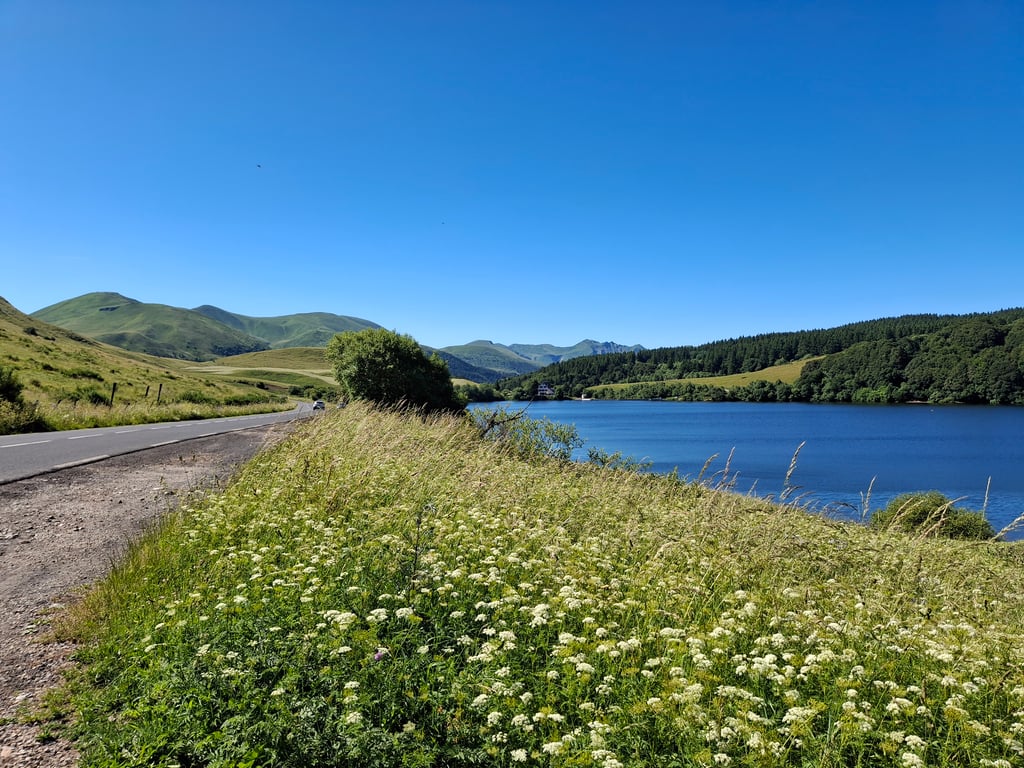
A nice pass linking Orcival to Lac du Guery, which will be used by the Tour de France in 2023 during the Vulcania Issoire stage. It's tough from the start as you leave Orcival, then eases off as you climb towards the Roches Tuilière. Beautiful views on the second part before entering the forest.

Un col sympas qui permet de relier Orcival au lac du Guery emprunté par le Tour de France en 2023 lors de l etape Vulcania Issoire. Costaud des le début à la sortie d Orcival puis ca se calme jusqu a la montée vers les roches tuilière. Très belle vue sur la deuxième partie avant d entrer dans la forêt.

Col de Guery from Orcival
Dashboard
Cyclauvergne
3 y 4.0 00:48:00 (11.8 km/h)
This is an automatic translation, the original language is: French. Show original

Nice slope, redone this year, in June (not my best climb with the pollens), but really nice slope with a nice view and a nice end in the forest when it's hot, The climb is on the other hand very irregular some be the slope, we start from Pont des Eaux by a medium slope, then a long flat before Orcival at the exit, from Orcival a wall at 9-10 rises to join the road to Rochefort;Orcival a wall at 9-10 rises to join the road to Rochefort, then becomes reasonable again, before a 1.5 km flat, then the final at 6-7% and after the crossroads at 2-3% where you pick up speed. At the top the Lac du Guéry is just the motivation to climb on Sunday mornings in spring with club mates.

Versant sympa, refait cette année, en juin (pas ma meilleure grimpée avec les pollens), mais versant vraiment sympa avec une belle vue et une fin dans la foret bien quand il fait chaud, La montée est par contre très irrégulière quelques soi le versant, on démarre de Pont des Eaux par une pente moyenne, puis un long replat avant Orcival à la sortie, d'Orcival un mur à 9-10 se dresse pour rejoindre la route qui va à Rochefort, puis à redevient raisonnable, avant un replat de 1 km et demi, puis le final à 6-7% et après le croisement à 2-3% où on reprend de la vitesse. En haut le Lac du Guéry est juste la motivation pour monter les dimanche matin du printemps avec les copains du club.

Dashboard

Climbing times

7 km/h 01:20:47
11 km/h 00:51:24
15 km/h 00:37:42
19 km/h 00:29:45

Road surface condition

100% 0% 0%
Based on 1 vote
Share your knowledge. What was the road condition during your ascent?

Traffic

100% 0% 0%
Based on 1 vote
Your experience counts. How much traffic did you encounter during the climb?

Frequently Asked Questions

Col de Guery can be cycled from 3 sides. Col de Guery from Orcival is the most popular side, but the summit can also be reached via Col de Guery from Rochefort Montagne & Col de Guéry from le Mont-Dore.

You don't need special gearing for Col de Guery from Orcival. The slope isn't long or steep enough to require much shifting down. You can conquer this climb on power alone. However, a compact gearing system with a smallest front chainring of 34 and largest rear sprocket of 28 or 30 is always nice if you enjoy cycling uphill. This helps maintain a smooth cadence.

Col de Guery from Orcival is a 3rd-category climb. Almost anyone can handle this climb, as long as you have a bike with climbing gears. If you have little training, you will probably need to shift down significantly. For experienced riders, Col de Guery from Orcival is not a problem.

Col de Guery from Orcival is 9.4 km long.

The average gradient of Col de Guery from Orcival is 4.2%.

Col de Guery from Orcival has a steepest segment with an average gradient of 12%.

The summit of Col de Guery from Orcival is at 1247 m.

At a slow pace of 7 km/h, it takes about 01:20:47 to climb Col de Guery from Orcival. At 11 km/h the time is 00:51:24, and at 15 km/h 00:37:42. For the fastest cyclists, 00:29:45 is an achievable time.

Col de Guery from Orcival is located in the region Puy-de-Dôme in France.

This page is better in the app

Climbfinder app
Climbfinder
(Free)
Open