Fort des Quatres Seigneurs from Gières is a climb in the region Grenoble. It is 9.4 km long and bridges 684 m of vertical ascent with an average gradient of 7.3%, resulting in a difficulty score of 752. The top of the ascent is located at 905 m above sea level. Climbfinder users shared 5 reviews of this climb and uploaded 5 photos.
Road name: D112
4.0 by Franck_PastorThis is an automatic translation, the original language is: French.The climb is particularly irregular, especially in the first part, up to Les Muriers. Then, after a short descent and a long false slope, the slope is generally steep and does not allow much respite until the summit. Note that the final altitude, that of the fort (934 m), is slightly higher than that indicated here (904 m). The fort itself is unfortunately not accessible to the public and appears to be very run down. Shortly before reaching it, a sign indicates that the area is currently in d... read more
Welcome! Please activate your account if you would like to share something. Look for the verification email in your inbox.
If you want to upload your photos, you need to create an account. It only takes 1 minute and it's completely free.
A lovely climb starting from Gières, which demands a lot of effort right from the start. There are a few sections where you can catch your breath, but the final stretch through the forest (which is lovely in hot weather) is gruelling, on a surface that offers little grip. This is the side best chosen for the ascent in winter, as the descent can be dangerous (leaves, black ice).
Une belle montée au départ de Gières, qui demande de l'engagement dès le pied. Quelques passages permettent de récupérer mais le final dans la forêt (appréciable par temps chaud) est redoutable, sur un revêtement qui ne rend pas. Versant à privilégier l'hiver pour la montée, la descente pouvant être dangereuse (feuilles, verglas)
Calm and pleasant ascent. It's uneven. You're in the shade in the forest, but there are still several viewpoints over Grenoble and as far as Chamrousse. The condition of the road is average on some sections.
Montée calme et agréable. C'est irrégulier. On est à l'ombre dans la forêt, mais il y a tout de même plusieurs points de vue sur Grenoble puis jusqu'à Chamrousse. L'état de la route est moyen sur certaines portions.
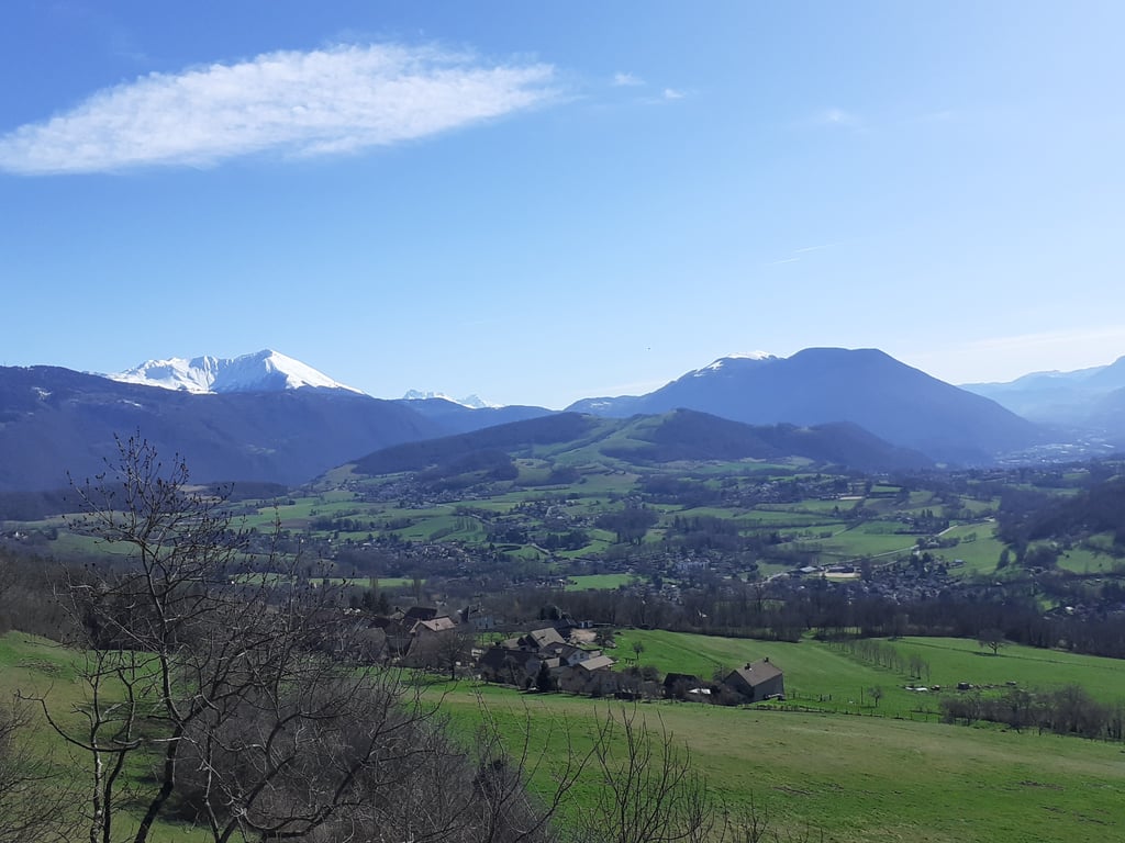
Fantastic climb that runs through the forest almost all the time, as a result it is nowhere too hot. Virtually no traffic, especially once you pass the village with the mini-descent. In the middle of the climb there is a small section that drops a bit, around this you can get some nice views of Grenoble and of the snow-capped Alpine peaks.
Although this is purely statistically tougher than the other side, it is more sheltered here. Whereas on the alternative, you cycle the entire climb in flat sun or wind.
Fantastische klim die bijna heel de tijd door het bos loopt, hierdoor is het nergens te warm. Nagenoeg geen verkeer, zeker als je het dorp met de mini-afdaling gepasseerd bent. In het midden van de klim is er een klein stukje dat even wat daalt, hierrond kan je een aantal mooie vergezichten krijgen over Grenoble en over de besneeuwde Alpentoppen.
Alhoewel deze puur statistisch zwaarder is dan de andere kant, is het hier wel meer beschut. Terwijl je bij het alternatief de gehele klim in de vlakke zon of wind fietst.
The climb is particularly irregular, especially in the first part, up to Les Muriers. Then, after a short descent and a long false slope, the slope is generally steep and does not allow much respite until the summit.
Note that the final altitude, that of the fort (934 m), is slightly higher than that indicated here (904 m). The fort itself is unfortunately not accessible to the public and appears to be very run down. Shortly before reaching it, a sign indicates that the area is currently in danger of a landslide.
Some nice views of the Grenoble area (in the first part of the climb) and then of the Herbeys plateau, the Taillefer and the southern end of the Belledonne range.
Montée particulièrement irrégulière en effet, surtout dans sa première moitié. Ensuite, après une courte descente et un long faux-plat montant, la pente, globalement raide, n'accorde plus guère de répit jusqu'au sommet.
À noter que l'altitude finale, celle du fort (937 m) est légèrement plus élevée que celle indiquée ici (905 m). Le fort lui-même n'est malheureusement pas accessible au public et semble abandonné. Peu avant d'y arriver, un panneau indique que la zone présente actuellement un danger d'éboulement.
Quelques beaux points de vue sur l'agglomération grenobloise (dans la première partie de la montée) et ensuite sur le plateau d'Herbeys, le Taillefer et l'extrémité sud de la chaîne de Belledonne.
I had done the other side first and found it quite complicated, and here it is the next level! Fortunately the big climbs are followed by small ones to rest, otherwise you would have to do the climb only in a dancer!
J'avais fait l'autre versant en premier et j'avais trouvé que c'était bien compliqué, et bien ici c'est le next level ! Heureusement que les gros pourcentages sont suivis par des petits pour se reposer, sinon il faudrait faire l'ascension qu'en danseuse !
| 7 km/h | 01:20:16 |
| 11 km/h | 00:51:04 |
| 15 km/h | 00:37:27 |
| 19 km/h | 00:29:34 |
This page is better in the app