View on map
© MapLibre | OpenStreetMap contributors
1%
2%
4%
6%
8%
10%
12%
15%
20%

Côte d'Équihen-Plage via Rue Albert Becart

3.0
3 reviews | Elevation profile | 11 photos
Tips nearby
Côte d'Équihen-Plage via Rue Albert Becart
Your achievable time
Calculating based on your best performances...
Relaxed
Maximum
W/kg
W/kg
W/kg
Analyse your climbing performance
Detailed insight into your climbing performance & automatically check off climbs
Based on your best performances.
Your best attempt:
Number of attempts:
Elevation profile Côte d'Équihen-Plage via Rue Albert Becart

Statistics

Difficulty points 62
Length 1.6 km
Average gradient 5.5%
Steepest 100 metres 11.5%
Total ascent 87 m
Feedback about this climb?
Show climbs nearby Export to GPS device

Côte d'Équihen-Plage via Rue Albert Becart is a climb in the region Caps et Marais d'Opale. It is 1.6 km long and bridges 87 m of vertical ascent with an average gradient of 5.5%, resulting in a difficulty score of 62. The top of the ascent is located at 93 m above sea level. Climbfinder users shared 3 reviews of this climb and uploaded 11 photos.

Road names: Rue Charles Cazin, Rue de la Marine, Rue Albert Bécard & Rue Edmond de Palézieux

3.0 by LarsG13
This is an automatic translation, the original language is: Dutch.
Nice climb that goes from the beach to the Equihen-Plage roundabout.... read more

Photos (11)

Côte d'Équihen-Plage via Rue Albert Becart
transparant thumb

Your uploads (max 4)

Welcome! Please activate your account if you would like to share something. Look for the verification email in your inbox.

If you want to upload your photos, you need to create an account. It only takes 1 minute and it's completely free.

  • Receive free climbfinder goodies for your reviews & photos.
  • Create a bucket list and check off conquered climbs.
  • Add missing climbs.
Continue with GoogleContinue with Google Continue with FacebookContinue with Facebook Continue with AppleContinue with Apple Sign up with email
By signing up you agree to our terms of service and confirm that you have read our privacy & content policy.

Reviews (3)

5.0
4.0
3.0
2.0
1.0
LarsG13
10 Mo 3.0
This is an automatic translation, the original language is: Dutch. Show original

Nice climb that goes from the beach to the Equihen-Plage roundabout.

Leuke klim die van het strand tot aan het rondpunt van Equihen-Plage gaat.

Dashboard
Cromagnon
1 y 3.0
This is an automatic translation, the original language is: French. Show original

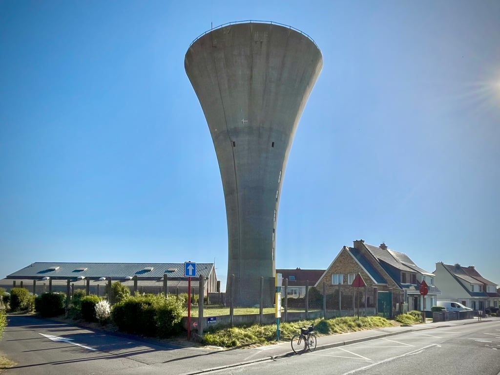
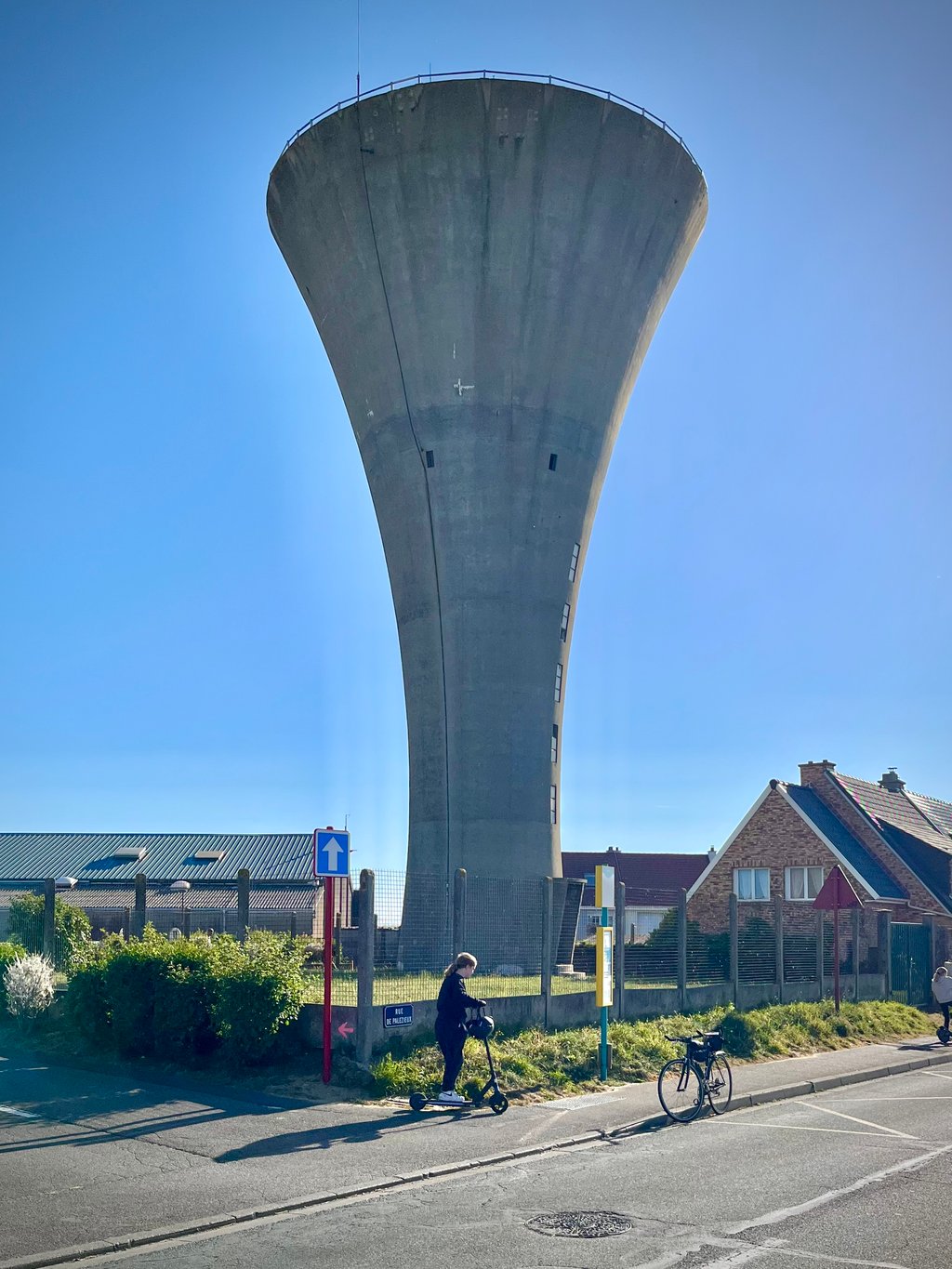
For these two climbs starting from Equihen beach, we can choose between the cemetery version and the water tower version! On the Mont d'Ecault, the two are combined for the souvenir photo.
Here, it's the big water tower version.
The starting point is beautiful, but I prefer the other alternative.
Here too, it climbs steeply at the start of the ascent, then calms down a hell of a lot to climb back up to that tiny peak at 13% that you can really feel. Everything unfolds between the detached houses. Even the water tower seems to be built in a garden. As with the cemetery version, three stars for the starting spot but only two for the cycling aspect.
Personally, I preferred the cemetery version.

Pour ces deux côtes qui partent de la plage d’Equihen, nous avons le choix entre la « version cimetière » et la « version château d’eau » !
Sur le Mont d’Ecault, les deux sont réunis pour la photo souvenir.
Ici, c’est la version gros château d’eau à l’arrivée.
Le point de départ est beau mais je préfère celui de l’autre alternative.
Là aussi, ça grimpe sèchement au début de la montée puis, ça s’apaise sacrément pour remonter jusqu’à ce minuscule pic à 13% que l’on ressent bien. 
Tout se déroule entre les maisons individuelles. Même le château d’eau semble construit dans un jardin. 
Comme pour la version cimetière, trois étoiles pour le spot de départ mais deux seulement pour l’aspect cycliste.
Personnellement, j’ai préféré la variante cimetière.

Côte d'Équihen-Plage via Rue Albert Becart
Dashboard
Leon
4 y 3.0
This is an automatic translation, the original language is: Dutch. Show original

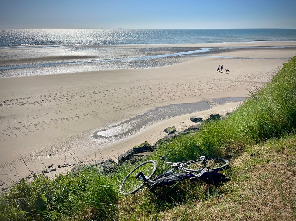
A climb that literally starts from the beach. The climb, which goes through the chic neighbourhoods of Équihen-Plage, contains 2 steep parts. Right from the beach, you go up a few hundred meters, then you even descend a bit, after which you have to cope with the steepest part of the climb in a residential area with typical red lampposts. It doesn't take long, but for a short while it goes up more than 10% meters. After that, there is only false flat until you reach the water tower.

Een klim die letterlijk vanaf het strand begint. De klim die door de chique wijken van Équihen-Plage loopt, bevat uit 2 steile stukken. Gelijk vanaf het strand ga je enkele honderde meters steil omhoog, daarna volgt zelfs een stukje afdaling, waarna je in een woonwijk met typische rode lantaarnpalen het steilste stukje van de klim te verwerken krijgt. Het duurt niet lang, maar even gaat het ruim boven de 10% omhoog. Daarna rest slechts nog vals plat tot je bij de watertoren aankomt.

Dashboard

Climbing times

7 km/h 00:13:27
11 km/h 00:08:34
15 km/h 00:06:17
19 km/h 00:04:57

Road surface condition

100% 0% 0%
Based on 1 vote
Share your knowledge. What was the road condition during your ascent?

Traffic

0% 100% 0%
Based on 1 vote
Your experience counts. How much traffic did you encounter during the climb?

Frequently Asked Questions

You don't need special gearing for Côte d'Équihen-Plage via Rue Albert Becart. The slope isn't long or steep enough to require much shifting down. You can conquer this climb on power alone. However, a compact gearing system with a smallest front chainring of 34 and largest rear sprocket of 28 or 30 is always nice if you enjoy cycling uphill. This helps maintain a smooth cadence.

Côte d'Équihen-Plage via Rue Albert Becart falls into the 5th category. With good fitness, you can ride it up with speed and power. If you have less training, shift down and climb smoothly.

Côte d'Équihen-Plage via Rue Albert Becart is 1.6 km long.

The average gradient of Côte d'Équihen-Plage via Rue Albert Becart is 5.5%.

Côte d'Équihen-Plage via Rue Albert Becart has a steepest segment with an average gradient of 11.5%.

The summit of Côte d'Équihen-Plage via Rue Albert Becart is at 93 m.

At a slow pace of 7 km/h, it takes about 00:13:27 to climb Côte d'Équihen-Plage via Rue Albert Becart. At 11 km/h the time is 00:08:34, and at 15 km/h 00:06:17. For the fastest cyclists, 00:04:57 is an achievable time.

Côte d'Équihen-Plage via Rue Albert Becart is located in the region Caps et Marais d'Opale in France.

This page is better in the app

Climbfinder app
Climbfinder
(Free)
Open