View on map
© MapLibre | OpenStreetMap contributors
1%
2%
4%
6%
8%
10%
12%
15%
20%

Col du Haut Jacques from Les Trois Scieries

2.0
1 review/story | Elevation profile | 4 photos
Tips nearby
Col du Haut Jacques from Les Trois Scieries
transparant thumb
transparant thumb
transparant thumb
transparant thumb
Your achievable time
Calculating based on your best performances...
Relaxed
Maximum
W/kg
W/kg
W/kg
Analyse your climbing performance
Detailed insight into your climbing performance & automatically check off climbs
Based on your best performances.
Your best attempt:
Number of attempts:
Elevation profile Col du Haut Jacques from Les Trois Scieries

Statistics

Difficulty points 163
Length 4.3 km
Average gradient 5.7%
Steepest 100 metres 10.9%
Total ascent 248 m
Feedback about this climb?
Show climbs nearby Export to GPS device

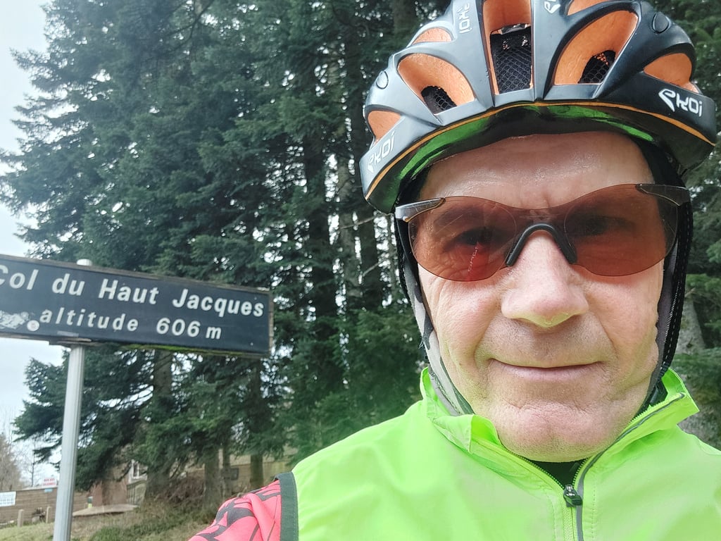
Col du Haut Jacques from Les Trois Scieries is a climb in the region Vosges. It is 4.3 km long and bridges 248 m of vertical ascent with an average gradient of 5.7%, resulting in a difficulty score of 163. The top of the ascent is located at 606 m above sea level. Climbfinder users shared 1 review/story of this climb and uploaded 4 photos.

Road name: D 420

2.0 by Froli
This is an automatic translation, the original language is: French.
A gentle climb on both sides, with no major gradients. The tarmac is fine and the road is wide. Climbs completed in January with virtually no traffic... read more

Photos (4)

Col du Haut Jacques from Les Trois Scieries
transparant thumb
transparant thumb

Your uploads (max 4)

Welcome! Please activate your account if you would like to share something. Look for the verification email in your inbox.

If you want to upload your photos, you need to create an account. It only takes 1 minute and it's completely free.

  • Receive free climbfinder goodies for your reviews & photos.
  • Create a bucket list and check off conquered climbs.
  • Add missing climbs.
Continue with GoogleContinue with Google Continue with FacebookContinue with Facebook Continue with AppleContinue with Apple Sign up with email
By signing up you agree to our terms of service and confirm that you have read our privacy & content policy.

Reviews (1)

5.0
4.0
3.0
2.0
1.0
Froli
1 y 2.0
This is an automatic translation, the original language is: French. Show original

A gentle climb on both sides, with no major gradients.
The tarmac is fine and the road is wide.
Climbs completed in January with virtually no traffic

Montée tranquille par les 2 cotés, pas de gros pourcentages.
Le bitume est correct et la route est large
Montées effectuées en janvier pratiquement pas de circulation

Dashboard

Climbing times

7 km/h 00:37:07
11 km/h 00:23:37
15 km/h 00:17:19
19 km/h 00:13:40

Road surface condition

100% 0% 0%
Based on 8 votes
Share your knowledge. What was the road condition during your ascent?

Traffic

29% 57% 14%
Based on 7 votes
Your experience counts. How much traffic did you encounter during the climb?

Frequently Asked Questions

Col du Haut Jacques can be cycled from 2 sides. Col du Haut Jacques from Maillefaing is the most popular side, but the summit can also be reached via Col du Haut Jacques from Les Trois Scieries.

You don't need special gearing for Col du Haut Jacques from Les Trois Scieries. The slope isn't long or steep enough to require much shifting down. You can conquer this climb on power alone. However, a compact gearing system with a smallest front chainring of 34 and largest rear sprocket of 28 or 30 is always nice if you enjoy cycling uphill. This helps maintain a smooth cadence.

Col du Haut Jacques from Les Trois Scieries is a 3rd-category climb. Almost anyone can handle this climb, as long as you have a bike with climbing gears. If you have little training, you will probably need to shift down significantly. For experienced riders, Col du Haut Jacques from Les Trois Scieries is not a problem.

Col du Haut Jacques from Les Trois Scieries is 4.3 km long.

The average gradient of Col du Haut Jacques from Les Trois Scieries is 5.7%.

Col du Haut Jacques from Les Trois Scieries has a steepest segment with an average gradient of 10.9%.

The summit of Col du Haut Jacques from Les Trois Scieries is at 606 m.

At a slow pace of 7 km/h, it takes about 00:37:07 to climb Col du Haut Jacques from Les Trois Scieries. At 11 km/h the time is 00:23:37, and at 15 km/h 00:17:19. For the fastest cyclists, 00:13:40 is an achievable time.

Col du Haut Jacques from Les Trois Scieries is located in the region Vosges in France.

This page is better in the app

Climbfinder app
Climbfinder
(Free)
Open