Tips nearby


| 11 hairpin turns |
| #33 toughest climb of Hautes-Pyrénées |
| #34 most elevation gain of Hautes-Pyrénées |
| #34 longest climb of Hautes-Pyrénées |
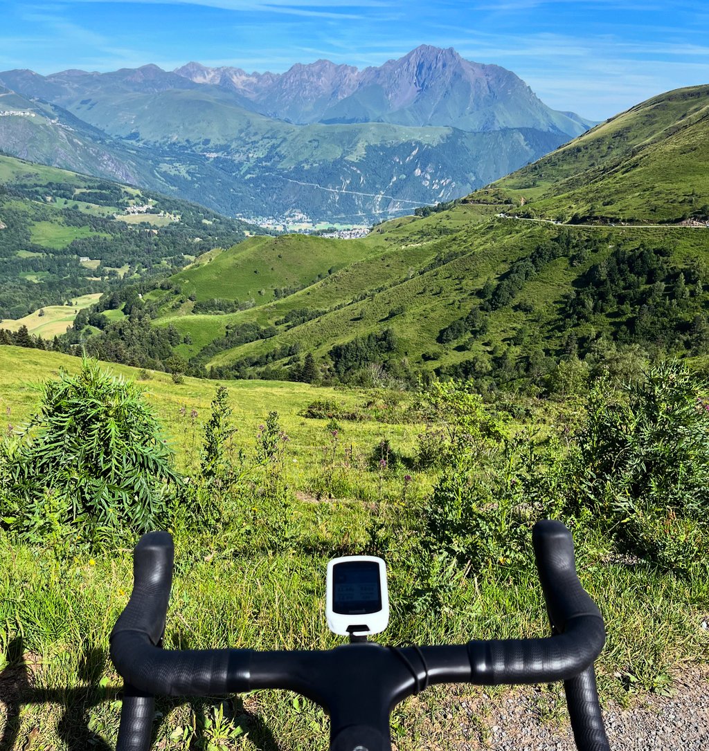
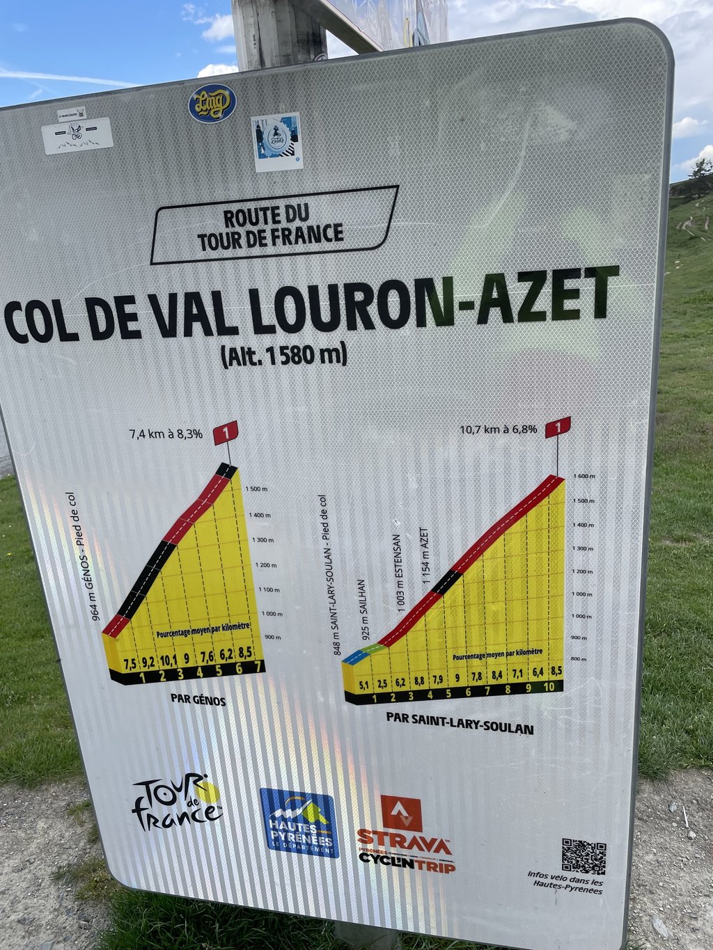
Col d'Azet / Val Louron from Saint Lary Soulan is a climb in the region Hautes-Pyrénées. It is 10.8 km long and bridges 759 m of vertical ascent with an average gradient of 7%, resulting in a difficulty score of 638. The top of the ascent is located at 1580 m above sea level. Climbfinder users shared 3 reviews of this climb and uploaded 4 photos.
Road names: D 25 & Route de Sailhan
5.0 by CyclopaatI missed this col when planning my trip for the day. I first went up to Lac d’Aumar and Lac d’Aubert, passing the entry to Col d'Azet while going in that direction and I included it on the return. It's by no means an easy climb, but the panorama at the summit is spectacular. Along the way up, you can see the road up Pla d'Adet/Col de Portet through the trees. The tarmac on the other end is a lot better, so going down to Génos is a treat.... read more
Welcome! Please activate your account if you would like to share something. Look for the verification email in your inbox.
If you want to upload your photos, you need to create an account. It only takes 1 minute and it's completely free.
On paper it looks simpler than the other side...
Well, it's possible, but you mustn't get the munchies at the start, because after that it seems longer...
Sur le papier semble plus simple que l'autre versant...
Bon c'est possible, mais pour ça il ne faut pas faire de fringale au début, car après ça paraît plus long...
I missed this col when planning my trip for the day. I first went up to Lac d’Aumar and Lac d’Aubert, passing the entry to Col d'Azet while going in that direction and I included it on the return. It's by no means an easy climb, but the panorama at the summit is spectacular. Along the way up, you can see the road up Pla d'Adet/Col de Portet through the trees. The tarmac on the other end is a lot better, so going down to Génos is a treat.
The beautiful Col d'Azet has a possible starting route (Route de Sailhan) from tourist St.Lary Soulan in addition to starting in Bourisp (as on Climbfinder map).
Climb then starts at sharp left turn at outdoor cycling centre towards Bielsa tunnel (Spain).
Immediately, the familiar cycling info signs are posted every kilometre from then on.
One cycles up through small picturesque villages. In Sailhan you join the other departure route to then cycle through Estensan via hairpin bends and finally turn and steeply through the narrow streets of Azet (namesake of the climb). From then on, the inhabited world ends and, especially in the last 4 kilometres, one enters an open pure nature "zone pastorale" with free-roaming cows next to and sometimes on the road. The last hairpin turn turns over the green treeless ridge that forms the summit and gives a beautiful 360° view of both valleys.
If you are staying in St.Lary Soulan, this beautiful irregular climb with no traffic is definitely recommended.
Was already included in the Tour route several times and in both cycling directions.
De prachtige Col d'Azet heeft naast vertrek in Bourisp (zoals op Climbfinder kaart) ook nog een mogelijke aanvangsroute (Route de Sailhan) vanuit toeristische St.Lary Soulan.
Klim start dan bij scherpe linkse afslag bij buitenfietsen centrum richting Bielsa tunnel (Spanje).
Direct zijn de bekende fietsinfobordjes vanaf dan ook elke kilometer op post.
Men fietst omhoog door kleine pittoreske dorpjes. In Sailhan vervoeg je de andere vertrekroute om dan via haarspeldbochten door Estensan en als laatste draaiend en steil door de smalle straatjes van Azet (naamgever van de klim) te fietsen. Vanaf dan eindigt de bewoonde wereld en komt men zeker in de laatste 4 kilometer in een open puur natuur "zone pastorale" terecht met vrij loslopende koeien naast en soms ook op de weg. De laatste haarspeldbocht draait over de groene boomloze heuvelkam die de top vormt en een prachtig 360° zicht geeft op beide valleien.
Als je verblijft in St.Lary Soulan is deze mooie onregelmatige klim zonder verkeer zeker een aanrader.
Was reeds meerdere malen en in beide fietsrichtingen opgenomen in het traject van de Tour.
| 7 km/h | 01:32:35 |
| 11 km/h | 00:58:55 |
| 15 km/h | 00:43:12 |
| 19 km/h | 00:34:06 |
This page is better in the app