View on map
© MapLibre | OpenStreetMap contributors
1%
2%
4%
6%
8%
10%
12%
15%
20%

Chandaneille from Lomprat

3.0
1 review/story | Elevation profile | 2 photos
Tips nearby
Chandaneille from Lomprat
transparant thumb
transparant thumb
transparant thumb
transparant thumb
transparant thumb
transparant thumb
Your achievable time
Calculating based on your best performances...
Relaxed
Maximum
W/kg
W/kg
W/kg
Analyse your climbing performance
Detailed insight into your climbing performance & automatically check off climbs
Based on your best performances.
Your best attempt:
Number of attempts:
Elevation profile Chandaneille from Lomprat

Statistics

Difficulty points 306
Length 7.9 km
Average gradient 5.3%
Steepest 100 metres 16%
Total ascent 414 m

Short recap

3 hairpin turns
#89 toughest climb of Auvergne
#91 most elevation gain of Auvergne
#63 longest climb of Puy-de-Dôme
Feedback about this climb?
Show climbs nearby Export to GPS device

Chandaneille from Lomprat is a climb in the region Puy-de-Dôme. It is 7.9 km long and bridges 414 m of vertical ascent with an average gradient of 5.3%, resulting in a difficulty score of 306. The top of the ascent is located at 1176 m above sea level. Climbfinder users shared 1 review/story of this climb and uploaded 2 photos.

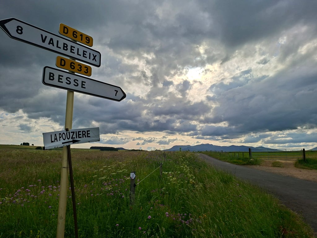
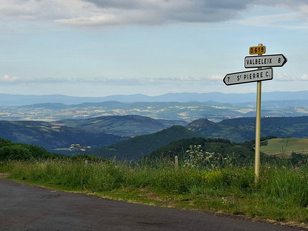
Road names: Route des Grottes & Chemin Rural de la Pouzière à Chevalière

3.0 by FrankvO86
This is an automatic translation, the original language is: Dutch.
The climb (D619) starts quietly from the hamlet of Lomprat. Somewhere at the start you are pointed to the Col de la Feuille at 870m altitude or so, but you ride past that without realising it. In the forest, the percentages go up. First 7-8%, but then it goes into double digits for a few hundred metres with peaks of 15%. Then it cools off and you ride to Trossange. From there a bit up and down the final kilometres. Stopped just past Chananeille at the junction with the D633 to Besse, but the hig... read more

Photos (2)

Chandaneille from Lomprat
transparant thumb
transparant thumb
transparant thumb
transparant thumb

Your uploads (max 4)

Welcome! Please activate your account if you would like to share something. Look for the verification email in your inbox.

If you want to upload your photos, you need to create an account. It only takes 1 minute and it's completely free.

  • Receive free climbfinder goodies for your reviews & photos.
  • Create a bucket list and check off conquered climbs.
  • Add missing climbs.
Continue with GoogleContinue with Google Continue with FacebookContinue with Facebook Continue with AppleContinue with Apple Sign up with email
By signing up you agree to our terms of service and confirm that you have read our privacy & content policy.

Reviews (1)

5.0
4.0
3.0
2.0
1.0
FrankvO86
2 d 3.0 via the Climbfinder app
This is an automatic translation, the original language is: Dutch. Show original

The climb (D619) starts quietly from the hamlet of Lomprat. Somewhere at the start you are pointed to the Col de la Feuille at 870m altitude or so, but you ride past that without realising it. In the forest, the percentages go up. First 7-8%, but then it goes into double digits for a few hundred metres with peaks of 15%. Then it cools off and you ride to Trossange. From there a bit up and down the final kilometres. Stopped just past Chananeille at the junction with the D633 to Besse, but the highest point is if you turn right 100 metres away, the Col des Paouins. Not recommended, but nothing wrong with it either. Forest, hamlets and nice expansive views when you reach the top.

De klim (D619) begint rustig vanuit het gehucht Lomprat. Ergens bij de start word je gewezen op de Col de la Feuille op 870m hoogte oid, maar daar rijd je voorbij zonder dat je het doorhebt. In het bos gaan de percentages omhoog. Eerst 7 a 8%, maar dan gaat het een paar honderd meter in de dubbele cijfers met uitschieters naar 15%. Daarna koelt het af en rij je naar Trossange. Vanaf daar een beetje op en af de laatste kilometers. Gestopt iets voorbij Chananeille bij de kruising met de D633 naar Besse, maar het hoogste punt ligt als je naar rechts gaat 100 meter verderop, de Col des Paouins. Geen aanrader, maar ook niks mis mee. Bos, gehuchtjes en mooi uitgestrekt uitzicht als je boven bent.

Chandaneille from Lomprat
Dashboard

Climbing times

7 km/h 01:07:23
11 km/h 00:42:53
15 km/h 00:31:26
19 km/h 00:24:49

Road surface condition

100% 0% 0%
Based on 1 vote
Share your knowledge. What was the road condition during your ascent?

Traffic

100% 0% 0%
Based on 1 vote
Your experience counts. How much traffic did you encounter during the climb?

Frequently Asked Questions

Chandaneille can be cycled from 3 sides. Chananelle from Valbeix is the most popular side, but the summit can also be reached via Côte du Fayet & Chandaneille from Lomprat.

You don't need special gearing for Chandaneille from Lomprat. The slope isn't long or steep enough to require much shifting down. You can conquer this climb on power alone. However, a compact gearing system with a smallest front chainring of 34 and largest rear sprocket of 28 or 30 is always nice if you enjoy cycling uphill. This helps maintain a smooth cadence.

Chandaneille from Lomprat is a serious climb and falls into the 2nd category. With a good basic fitness level, even without much cycling experience, you can complete this climb just fine. However, a bike with climbing gears is a must. Without experience or training, it will be really tough – but that’s part of the challenge!

Chandaneille from Lomprat is 7.9 km long.

The average gradient of Chandaneille from Lomprat is 5.3%.

Chandaneille from Lomprat has a steepest segment with an average gradient of 16%.

The summit of Chandaneille from Lomprat is at 1176 m.

At a slow pace of 7 km/h, it takes about 01:07:23 to climb Chandaneille from Lomprat. At 11 km/h the time is 00:42:53, and at 15 km/h 00:31:26. For the fastest cyclists, 00:24:49 is an achievable time.

Chandaneille from Lomprat is located in the region Puy-de-Dôme in France.

This page is better in the app

Climbfinder app
Climbfinder
(Free)
Open