View on map
© MapLibre | OpenStreetMap contributors
1%
2%
4%
6%
8%
10%
12%
15%
20%

Chalet du Gioberney from La Chapelle en Valgaudemar

5.0
2 reviews | Elevation profile | 3 photos
Tips nearby
Chalet du Gioberney from La Chapelle en Valgaudemar
transparant thumb
transparant thumb
transparant thumb
transparant thumb
transparant thumb
Your achievable time
Calculating based on your best performances...
Relaxed
Maximum
W/kg
W/kg
W/kg
Analyse your climbing performance
Detailed insight into your climbing performance & automatically check off climbs
Based on your best performances.
Your best attempt:
Number of attempts:
Elevation profile Chalet du Gioberney from La Chapelle en Valgaudemar

Statistics

Difficulty points 470
Length 9.4 km
Average gradient 6%
Steepest 100 metres 16.9%
Total ascent 565 m

Short recap

Beautiful scenery
Hidden gem
#41 toughest climb of Hautes Alpes
#46 most elevation gain of Hautes Alpes
#51 longest climb of Hautes Alpes
Feedback about this climb?
Show climbs nearby Export to GPS device

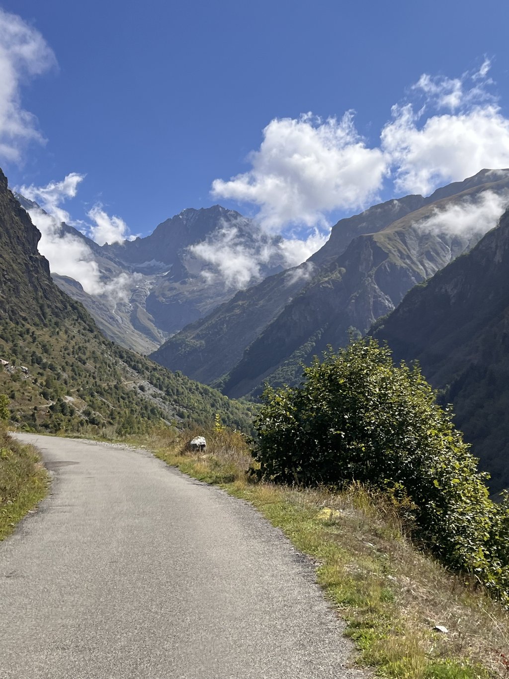
Chalet du Gioberney from La Chapelle en Valgaudemar is a climb in the region Hautes Alpes. It is 9.4 km long and bridges 565 m of vertical ascent with an average gradient of 6%, resulting in a difficulty score of 470. The top of the ascent is located at 1643 m above sea level. Climbfinder users shared 2 reviews of this climb and uploaded 3 photos.

Road name: D480

5.0 by AntoineR86
This is an automatic translation, the original language is: French.
We climbed from the village of Saint Firmin via the village of Le Sechier. This avoids part of the main road and the view is quite rural! It's after the village of La Chapelle en Valgaudémar that the gradients start to make themselves felt. The finish at the Gioberney refuge is exceptional, and the blueberry tart is well deserved! Best done in September for less traffic.... read more

Photos (3)

Chalet du Gioberney from La Chapelle en Valgaudemar
transparant thumb
transparant thumb
transparant thumb

Your uploads (max 4)

Welcome! Please activate your account if you would like to share something. Look for the verification email in your inbox.

If you want to upload your photos, you need to create an account. It only takes 1 minute and it's completely free.

  • Receive free climbfinder goodies for your reviews & photos.
  • Create a bucket list and check off conquered climbs.
  • Add missing climbs.
Continue with GoogleContinue with Google Continue with FacebookContinue with Facebook Continue with AppleContinue with Apple Sign up with email
By signing up you agree to our terms of service and confirm that you have read our privacy & content policy.

Reviews (2)

5.0
4.0
3.0
2.0
1.0
AntoineR86
9 Mo 5.0 via the Climbfinder app
This is an automatic translation, the original language is: French. Show original

We climbed from the village of Saint Firmin via the village of Le Sechier. This avoids part of the main road and the view is quite rural! It's after the village of La Chapelle en Valgaudémar that the gradients start to make themselves felt. The finish at the Gioberney refuge is exceptional, and the blueberry tart is well deserved! Best done in September for less traffic.

nous avons fait la grimpette depuis le village de Saint Firmin en passant par le village du Sechier. Cela évite une partie de la route départementale et la vue est plutot champêtre ! C’est après le village de la Chapelle en Valgaudémar que les pourcentages se font sentir. L’arrivée au refuge du Gioberney est exceptionnelle et la tarte aux Myrtilles se mérite ! À faire au mois de septembre pour moins de circulation.

Dashboard
Pierrebastia
2 y 5.0
This is an automatic translation, the original language is: French. Show original

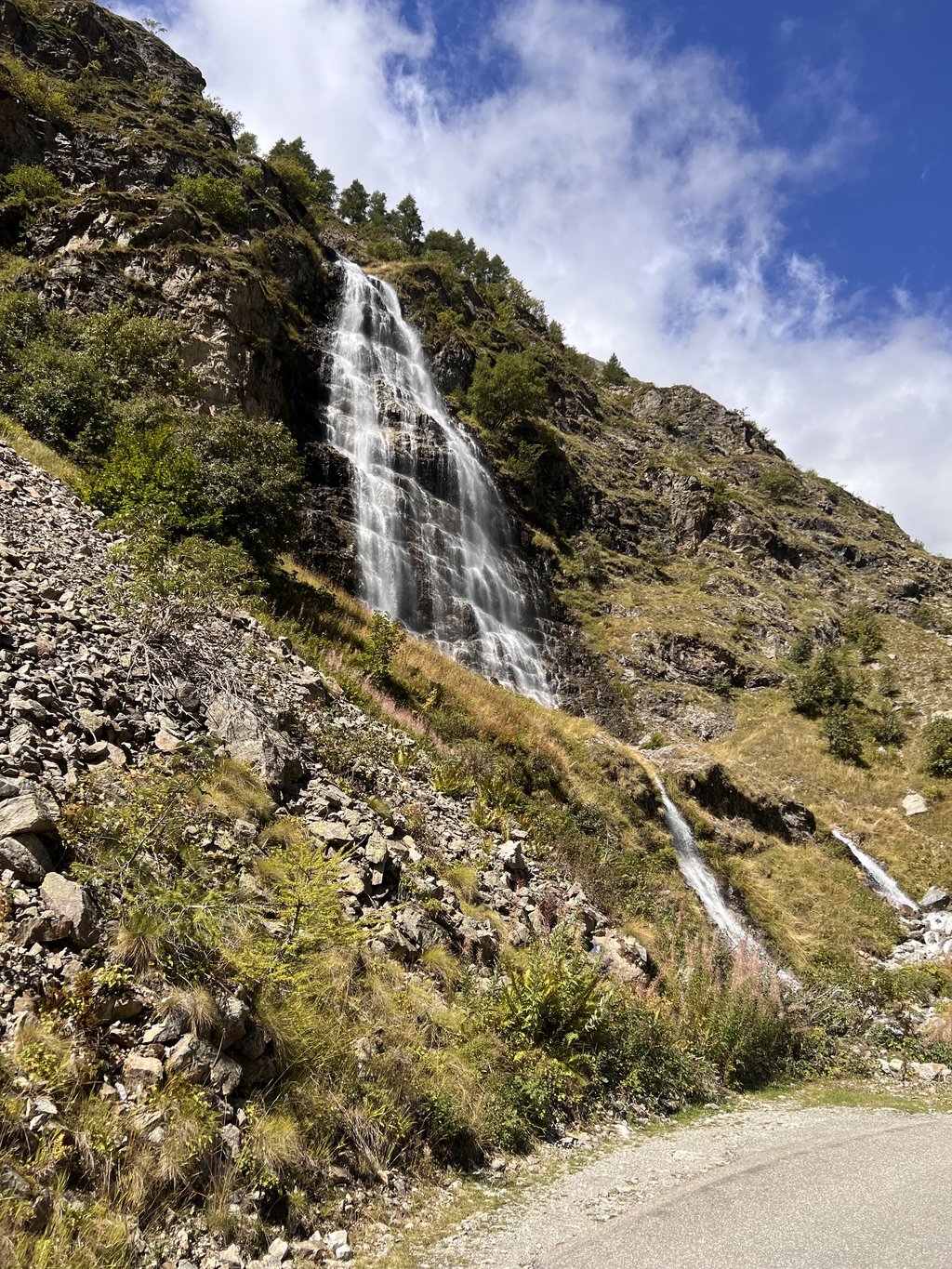
The ascent was made from the junction with the RN 85, which means an extra 25 km of ascent and 300 vertical metres. The extra kilometres are a good warm-up. From La Chapelle, the climb is magnificent. Beautiful waterfalls, a mountain atmosphere and marmots.
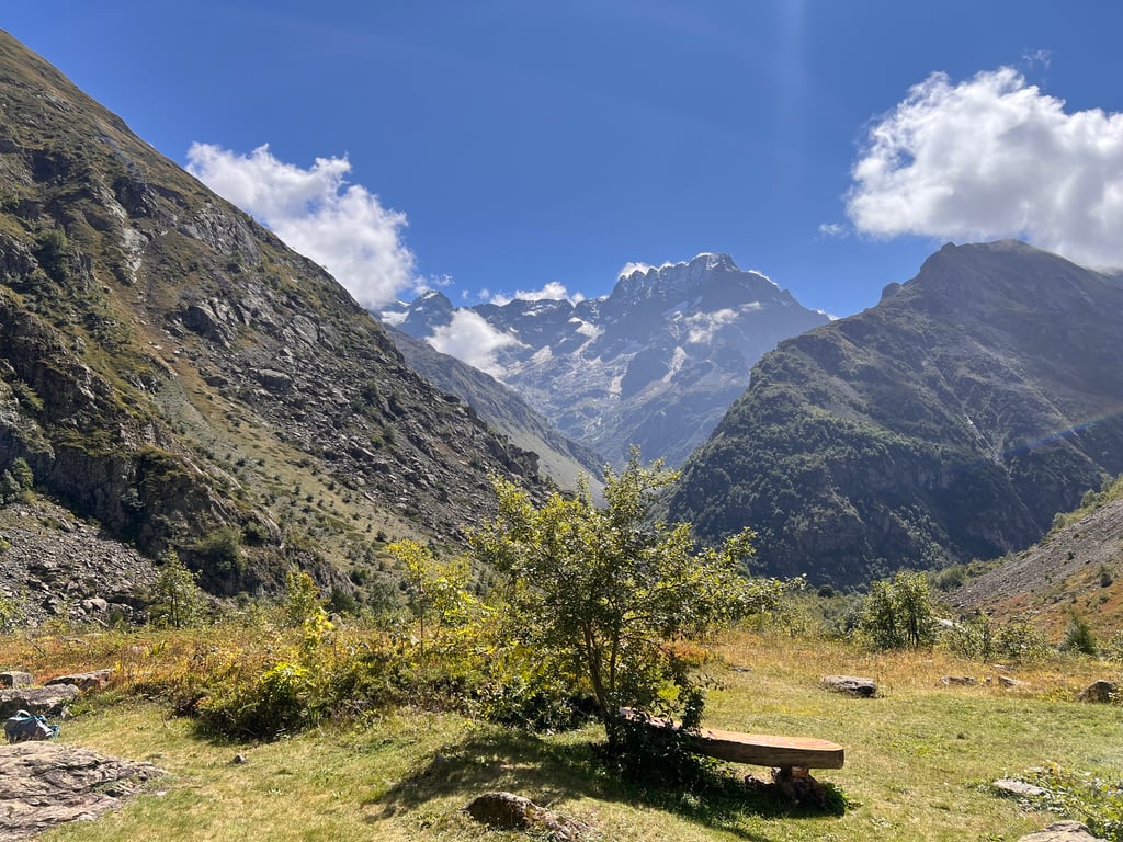
The arrival at the refuge is nice, the cirque is impressive and the atmosphere is mountainous.
As for the climb, there were two very steep sections, the first at 5 km, 1200 metres at an average of 11.3 on my Garmin, and the second one kilometre before the finish.

Montée réalisée depuis l'embranchement avec la RN 85, ce qui fait 25 km de montée et 300 de dénivellation en plus. Les km supplémentaires sont une bonne mise en jambe. À partir de La Chapelle, la montée est magnifique. Jolies cascades, ambiance montagne, et marmottes.
L'arrivée au refuge est sympa, le cirque est impressionnant et on est dans une ambiance haute montagne.
Quand à la montée, deux passages très raides, le premier à 5 km, 1200 mètres à 11,3 moyenne sur mon Garmin, le deuxième un kilomètres avant l'arrivée.

Dashboard

Climbing times

7 km/h 01:20:27
11 km/h 00:51:11
15 km/h 00:37:32
19 km/h 00:29:38

Road surface condition

0% 50% 50%
Based on 2 votes
Share your knowledge. What was the road condition during your ascent?

Traffic

0% 0% 100%
Based on 1 vote
Your experience counts. How much traffic did you encounter during the climb?

Frequently Asked Questions

Chalet du Gioberney from La Chapelle en Valgaudemar is a challenging ascent. For this type of climbing, we recommend mountain gearing, specifically a compact system. This means a small front chainring of 34 teeth, combined with a rear cassette where, depending on your level, strength, and experience, you choose a sprocket with 30, 32, or even 34 teeth. Remember that a smooth cadence is always more efficient!

Chalet du Gioberney from La Chapelle en Valgaudemar is a serious climb and falls into the 2nd category. With a good basic fitness level, even without much cycling experience, you can complete this climb just fine. However, a bike with climbing gears is a must. Without experience or training, it will be really tough – but that’s part of the challenge!

Chalet du Gioberney from La Chapelle en Valgaudemar is 9.4 km long.

The average gradient of Chalet du Gioberney from La Chapelle en Valgaudemar is 6%.

Chalet du Gioberney from La Chapelle en Valgaudemar has a steepest segment with an average gradient of 16.9%.

The summit of Chalet du Gioberney from La Chapelle en Valgaudemar is at 1643 m.

At a slow pace of 7 km/h, it takes about 01:20:27 to climb Chalet du Gioberney from La Chapelle en Valgaudemar. At 11 km/h the time is 00:51:11, and at 15 km/h 00:37:32. For the fastest cyclists, 00:29:38 is an achievable time.

Chalet du Gioberney from La Chapelle en Valgaudemar is located in the region Hautes Alpes in France.

This page is better in the app

Climbfinder app
Climbfinder
(Free)
Open