| Rank | Climb |
|---|---|
|
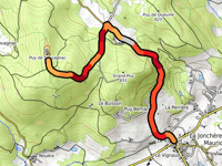
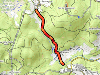
Puy de Sauvagnac from La Jonchère-Saint-Maurice
2.5 mi
6.9%
237
|
|
|
Signal de Beausoleil
2.4 mi
5.9%
200
|
|
|
Bois des Échelles from Galachoux
3.6 mi
5.4%
197
|
|
| 4 |
Signal de Beausoleil from Compreignac
2.7 mi
5.3%
164
|
| 5 |
Côte de Tarnac
5.5 mi
3.6%
160
|
| 6 |
Bois des Échelles from Saint-Sulpice-Laurière
2.5 mi
5.7%
155
|
| 7 |
Signal de Beausoleil from Compreignac via Route d'Angelard
2.1 mi
6.3%
147
|
| 8 |
Signal de Beausoleil from Gabatoux
2.9 mi
4.4%
142
|
| 9 |
Signal de Beausoleil via Népoulas
2.3 mi
5.2%
142
|
| 10 |
Sommet des Cars via Le Brueil
2.7 mi
4.6%
128
|
In the region Haute-Vienne cyclists can find 41 interesting climbs between 558 ft and 2753 ft above sea level. Puy de Sauvagnac from La Jonchère-Saint-Maurice is the toughest ascent with a difficulty score of 237. Climbs have an average length of 1.9 mi and 482 ft of total ascent.
This page is better in the app