Compare your performances with others in the Climbfinder App
Discover
Map
Regions
Ranking
Analytics
Premium
Climbs
No results found
Regions
No results found
Places
No results found
US
English
English (US units)
Nederlands
Français
Deutsch
Italiano
Español
Polski
Dashboard
My routes
My climbs
Climbfinder goodies
Settings
Log out
Continue with Google
Continue with Facebook
Continue with Apple
or
Log in
Sign up
Home
Ranking
Most popular climbs - Stuttgart
The ultimate climbing rankings
Most popular
Most popular
Toughest
Steepest
Longest
Elevation gain
Highest
Hairpins
Best rated
Stuttgart
Regions
No results found
Places
No results found
My location
Retrieving location...
Browser location not shared
Remove current selection
All
Bucket list
312
climbs
0.0
% ridden
Previous
Next
Loading...
No climbs found
101
Your best attempt:
Climbed
Bucket list climb
Not yet climbed
Dittwarer Berg from Dittwar
1.1 mi
7.0%
101
390 ft
1135 ft
4
102
Your best attempt:
Climbed
Bucket list climb
Not yet climbed
Hölzernes Bild from Grünsfeld via Kapellenstrasse
0.6 mi
7.7%
80
259 ft
994 ft
4
103
Your best attempt:
Climbed
Bucket list climb
Not yet climbed
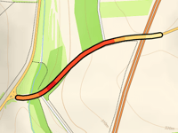
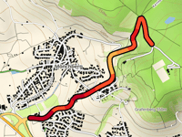
Eichelsteige
1 mi
8.7%
144
469 ft
925 ft
4
104
Your best attempt:
Climbed
Bucket list climb
Not yet climbed
Kleiner First from Dertingen
1.2 mi
6.0%
74
364 ft
928 ft
5
105
Your best attempt:
Climbed
Bucket list climb
Not yet climbed
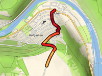
Eichelsteige from Hofgarten
1.1 mi
8.0%
132
456 ft
925 ft
4
106
Your best attempt:
Climbed
Bucket list climb
Not yet climbed
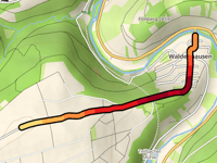
Rauenberg from Waldenhausen
1.3 mi
7.6%
152
525 ft
994 ft
3
107
Your best attempt:
Climbed
Bucket list climb
Not yet climbed
Herrenberg via Osterloch
1.5 mi
5.5%
99
443 ft
1070 ft
4
108
Your best attempt:
Climbed
Bucket list climb
Not yet climbed
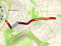
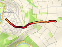
Reicholzheimer First via Zum Satzenberg
1.2 mi
7.5%
151
463 ft
922 ft
3
109
Your best attempt:
Climbed
Bucket list climb
Not yet climbed
Neue Vockenroter Steige
2.2 mi
5.0%
105
587 ft
1050 ft
1
4
110
Your best attempt:
Climbed
Bucket list climb
Not yet climbed
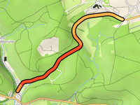
Hühberg from Ilmspan
0.7 mi
4.0%
21
157 ft
1089 ft
111
Your best attempt:
Climbed
Bucket list climb
Not yet climbed
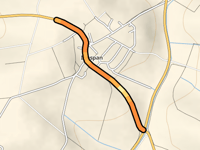
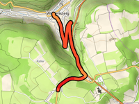
Kirchweihbückel from Wiesensteig
1.5 mi
6.4%
114
525 ft
2454 ft
4
112
Your best attempt:
Climbed
Bucket list climb
Not yet climbed
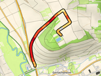
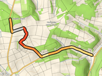
Köpfle via Hoffeld
2.6 mi
3.1%
59
433 ft
1316 ft
5
113
Your best attempt:
Climbed
Bucket list climb
Not yet climbed
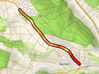
Bergwald from Dachtel
1.2 mi
4.9%
56
312 ft
1778 ft
5
114
Your best attempt:
Climbed
Bucket list climb
Not yet climbed
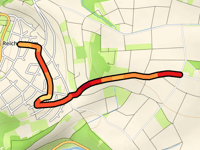
Reicholzheimer First via Schillstrasse
1 mi
8.3%
130
430 ft
922 ft
4
115
Your best attempt:
Climbed
Bucket list climb
Not yet climbed
Möttlonger Köpfle from Weil der Stadt
2.7 mi
4.1%
115
587 ft
1877 ft
4
116
Your best attempt:
Climbed
Bucket list climb
Not yet climbed
Reicholzheimer First via Zu den Kreuzen
1.3 mi
6.2%
92
427 ft
922 ft
1
4
117
Your best attempt:
Climbed
Bucket list climb
Not yet climbed
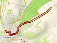
Hölzernes Bild from Grünsfeld
1.1 mi
4.6%
45
259 ft
988 ft
1
5
118
Your best attempt:
Climbed
Bucket list climb
Not yet climbed
Grünsfelder Höhe from Rödersteinsgraben
0.5 mi
5.2%
25
131 ft
1053 ft
5
119
Your best attempt:
Climbed
Bucket list climb
Not yet climbed
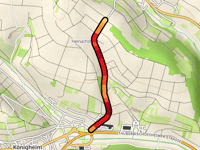
Heinachshöhe via Königheim
0.9 mi
8.0%
97
361 ft
1089 ft
4
120
Your best attempt:
Climbed
Bucket list climb
Not yet climbed
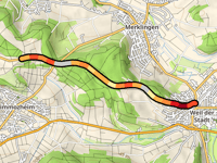
Schallberg from Merklingen
1.3 mi
2.8%
21
187 ft
1463 ft
121
Your best attempt:
Climbed
Bucket list climb
Not yet climbed
Wurmberg from Wenkheim
1.7 mi
4.5%
77
400 ft
1129 ft
4
122
Your best attempt:
Climbed
Bucket list climb
Not yet climbed
Grafenberg via Schönbuchstrasse
1 mi
7.6%
101
404 ft
1778 ft
1
4
123
Your best attempt:
Climbed
Bucket list climb
Not yet climbed
Waldenbucher Strasse from Burkhardtsmühle
1.4 mi
5.1%
68
381 ft
1480 ft
5
124
Your best attempt:
Climbed
Bucket list climb
Not yet climbed
Hohe Hardt from Grünsfeld via Laistrasse
1.6 mi
5.3%
86
436 ft
1148 ft
4
125
Your best attempt:
Climbed
Bucket list climb
Not yet climbed
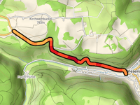
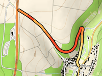
Lämmerbuckel from Wiesensteig
1.9 mi
7.1%
154
702 ft
2638 ft
2
3
Previous
Next
Your best attempt:
Climbed
Bucket list climb
Not yet climbed
a
This page is better in the app
Climbfinder
(Free)
Open