Improve your climb times with the Climbfinder App
Discover
Map
Regions
Ranking
Analytics
Premium
Climbs
No results found
Regions
No results found
Places
No results found
US
English
English (US units)
Nederlands
Français
Deutsch
Italiano
Español
Polski
Dashboard
My routes
My climbs
Climbfinder goodies
Settings
Log out
Continue with Google
Continue with Facebook
Continue with Apple
or
Log in
Sign up
Home
Ranking
Most popular climbs - Thuringian-Franconian Highlands
The ultimate climbing rankings
Most popular
Most popular
Toughest
Steepest
Longest
Elevation gain
Highest
Hairpins
Best rated
Thuringian-Franconian Highlands
Regions
No results found
Places
No results found
My location
Retrieving location...
Browser location not shared
Remove current selection
All
Bucket list
292
climbs
0.0
% ridden
Previous
Next
Loading...
No climbs found
Your best attempt:
Climbed
Bucket list climb
Not yet climbed
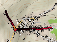
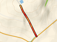
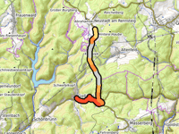
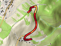
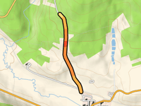
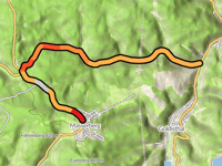
Steile Wand von Deesbach via Oberweissbacher Strasse
0.5 mi
16.8%
239
427 ft
2405 ft
3
Your best attempt:
Climbed
Bucket list climb
Not yet climbed
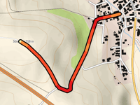
Talsperre Schönbrunn from Schönbrunn
1.5 mi
3.8%
55
305 ft
1791 ft
5
Your best attempt:
Climbed
Bucket list climb
Not yet climbed
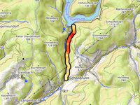
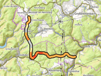
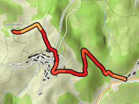
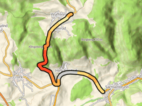
Masserberg from Schwarzatal
2.8 mi
7.4%
332
1073 ft
2579 ft
2
4
Your best attempt:
Climbed
Bucket list climb
Not yet climbed
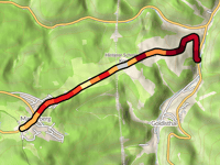
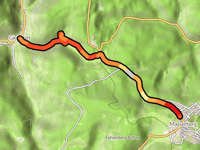
Kahlert from Giessübel
4.2 mi
4.0%
149
892 ft
2612 ft
1
4
5
Your best attempt:
Climbed
Bucket list climb
Not yet climbed
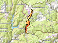
Kohlhieb from Massertal
7.1 mi
3.3%
172
1247 ft
2612 ft
3
6
Your best attempt:
Climbed
Bucket list climb
Not yet climbed
Kalkstein from Eisfeld
0.4 mi
6.6%
30
144 ft
1670 ft
5
7
Your best attempt:
Climbed
Bucket list climb
Not yet climbed
Masserberg via Fehrenbach
3.9 mi
4.4%
165
909 ft
2575 ft
3
8
Your best attempt:
Climbed
Bucket list climb
Not yet climbed
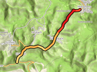
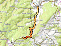
Fröbelturm / Kirchberg from Unterweissbach
5 mi
5.7%
308
1512 ft
2572 ft
2
2
9
Your best attempt:
Climbed
Bucket list climb
Not yet climbed
Kohlhieb from Giessübel via Schwalbenhaupt
5 mi
4.0%
188
1047 ft
2612 ft
2
3
10
Your best attempt:
Climbed
Bucket list climb
Not yet climbed
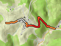
Simmersberg from Heubach via Schnett
1.9 mi
7.5%
194
764 ft
2556 ft
3
3
11
Your best attempt:
Climbed
Bucket list climb
Not yet climbed
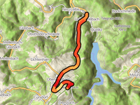
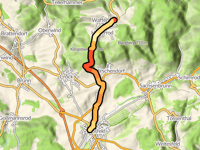
Rotkopf from Gehren
5.6 mi
3.7%
158
1093 ft
2628 ft
3
12
Your best attempt:
Climbed
Bucket list climb
Not yet climbed
Kalkstein from Crock
0.7 mi
5.4%
39
207 ft
1670 ft
5
13
Your best attempt:
Climbed
Bucket list climb
Not yet climbed
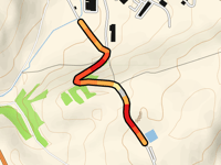
Fröbelturm / Kirchberg from Deesbach
1.3 mi
8.9%
182
594 ft
2572 ft
3
14
Your best attempt:
Climbed
Bucket list climb
Not yet climbed
Süssberg from Brattendorf
0.7 mi
7.1%
54
243 ft
1699 ft
5
15
Your best attempt:
Climbed
Bucket list climb
Not yet climbed
Waffenrod from Sachsenbrunn
4.5 mi
3.4%
134
804 ft
2277 ft
4
16
Your best attempt:
Climbed
Bucket list climb
Not yet climbed
Masserberg from Giessübel via Schwalbenhaupt
3 mi
5.3%
167
843 ft
2569 ft
2
3
17
Your best attempt:
Climbed
Bucket list climb
Not yet climbed
Rotkopf from Oelze
5.9 mi
3.8%
176
1191 ft
2631 ft
3
18
Your best attempt:
Climbed
Bucket list climb
Not yet climbed
Kahlert from Oelze
6.7 mi
3.2%
157
1135 ft
2612 ft
1
3
19
Your best attempt:
Climbed
Bucket list climb
Not yet climbed
Kohlberg from Schönbrunn
3.1 mi
5.5%
169
896 ft
2372 ft
3
3
20
Your best attempt:
Climbed
Bucket list climb
Not yet climbed
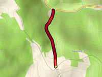
Steile Wand von Deesbach
1 mi
9.3%
224
472 ft
2438 ft
3
21
Your best attempt:
Climbed
Bucket list climb
Not yet climbed
Thomasberg from Harras
0.9 mi
4.2%
27
190 ft
1532 ft
5
22
Your best attempt:
Climbed
Bucket list climb
Not yet climbed
Oberwinder Berg from Bibertal
0.6 mi
11.2%
118
335 ft
1854 ft
4
23
Your best attempt:
Climbed
Bucket list climb
Not yet climbed
Waffenrod from Eisfeld
4.4 mi
3.7%
143
860 ft
2277 ft
4
24
Your best attempt:
Climbed
Bucket list climb
Not yet climbed
Kohlberg from Heubach via Schnett
1.8 mi
6.2%
137
591 ft
2369 ft
3
4
25
Your best attempt:
Climbed
Bucket list climb
Not yet climbed
Masserberg from Massertal via Schwalbenhaupt
5.2 mi
3.9%
162
1066 ft
2569 ft
3
Previous
Next
Your best attempt:
Climbed
Bucket list climb
Not yet climbed
a
This page is better in the app
Climbfinder
(Free)
Open