Analyze your climb times with the Climbfinder App
Discover
Map
Regions
Ranking
Analytics
Premium
Climbs
No results found
Regions
No results found
Places
No results found
US
English
English (US units)
Nederlands
Français
Deutsch
Italiano
Español
Polski
Dashboard
My routes
My climbs
Climbfinder goodies
Settings
Log out
Continue with Google
Continue with Facebook
Continue with Apple
or
Log in
Sign up
Home
Ranking
Most popular climbs - Saxony
The ultimate climbing rankings
Most popular
Most popular
Toughest
Steepest
Longest
Elevation gain
Highest
Hairpins
Best rated
Saxony
Regions
No results found
Places
No results found
My location
Retrieving location...
Browser location not shared
Remove current selection
All
Bucket list
336
climbs
0.0
% ridden
Previous
Next
Loading...
No climbs found
226
Your best attempt:
Climbed
Bucket list climb
Not yet climbed
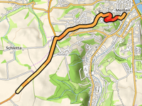
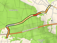
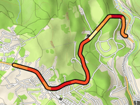
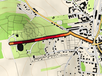
Korbitzhöhe via Jüdenbergstrasse
2.6 mi
3.5%
69
476 ft
823 ft
1
5
227
Your best attempt:
Climbed
Bucket list climb
Not yet climbed
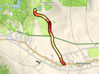
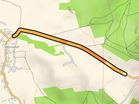
Schwalbenberg from Königshain
1.1 mi
4.1%
50
233 ft
1037 ft
5
228
Your best attempt:
Climbed
Bucket list climb
Not yet climbed
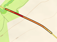
Pfaffenberg from Plotzen / Błócany
1.6 mi
2.8%
31
233 ft
1079 ft
5
229
Your best attempt:
Climbed
Bucket list climb
Not yet climbed
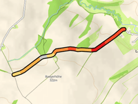
Bocksberg from Winkwitz
0.6 mi
2.4%
8
75 ft
554 ft
230
Your best attempt:
Climbed
Bucket list climb
Not yet climbed
Butterberg from Wiesa
1.8 mi
2.3%
30
217 ft
774 ft
5
231
Your best attempt:
Climbed
Bucket list climb
Not yet climbed
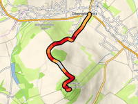
Oderwitzer Spitzberg from Oberoderwitz
1.7 mi
6.7%
144
587 ft
1604 ft
4
232
Your best attempt:
Climbed
Bucket list climb
Not yet climbed
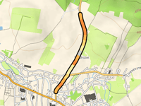
Korbitzhöhe from Rauenthal
2.4 mi
3.6%
63
459 ft
823 ft
2
5
233
Your best attempt:
Climbed
Bucket list climb
Not yet climbed
Heideberg from Gohrisch
1.9 mi
6.2%
142
623 ft
1050 ft
4
234
Your best attempt:
Climbed
Bucket list climb
Not yet climbed
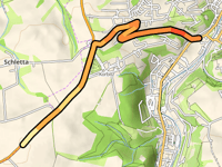
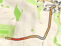
Sieberec hórka from Meschwitz
1.1 mi
3.4%
27
194 ft
1024 ft
5
235
Your best attempt:
Climbed
Bucket list climb
Not yet climbed
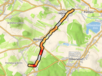
Steinbusch from Hörnitz
3.4 mi
3.1%
84
554 ft
1309 ft
4
236
Your best attempt:
Climbed
Bucket list climb
Not yet climbed
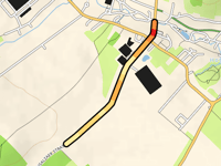
Ziegelei from Schönbach
0.7 mi
2.1%
8
75 ft
1293 ft
237
Your best attempt:
Climbed
Bucket list climb
Not yet climbed
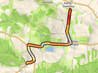
Schafberg from Rachlau / Rachlow
2.6 mi
3.4%
75
453 ft
1155 ft
4
238
Your best attempt:
Climbed
Bucket list climb
Not yet climbed
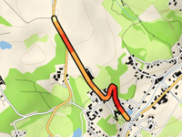
Fastenberg / Eibenstockerstrasse via Steigerstrasse
2.3 mi
6.2%
160
741 ft
2927 ft
3
239
Your best attempt:
Climbed
Bucket list climb
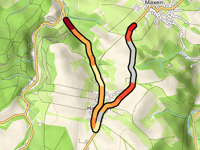
Not yet climbed
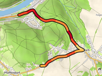
Rehnsdorf from Möhrsdorf
1.1 mi
3.4%
22
190 ft
1014 ft
240
Your best attempt:
Climbed
Bucket list climb
Not yet climbed
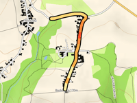
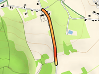
Dieterbacher Höhe from Weissbach
0.3 mi
5.1%
16
92 ft
873 ft
241
Your best attempt:
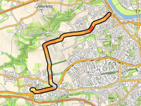
Climbed
Bucket list climb
Not yet climbed
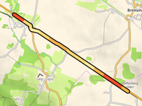
Baeyerhöhe from Lampesdorf
1 mi
4.4%
40
230 ft
1010 ft
5
242
Your best attempt:
Climbed
Bucket list climb
Not yet climbed
Hutberg from Kamenz - Kamjenc
0.6 mi
8.7%
92
282 ft
945 ft
4
243
Your best attempt:
Climbed
Bucket list climb
Not yet climbed
Galgenberg from Neukirch / Lausitz
1 mi
2.7%
16
141 ft
1191 ft
244
Your best attempt:
Climbed
Bucket list climb
Not yet climbed
Weinberg from Hainewalde
0.7 mi
5.1%
33
180 ft
1119 ft
1
5
245
Your best attempt:
Climbed
Bucket list climb
Not yet climbed
Tannenhof from Beiersdorf
0.4 mi
4.8%
14
89 ft
1322 ft
246
Your best attempt:
Climbed
Bucket list climb
Not yet climbed
Finckenfang via Hausdorf
2.8 mi
3.6%
113
535 ft
1280 ft
4
247
Your best attempt:
Climbed
Bucket list climb
Not yet climbed
Gompitzer Höhe via Ockerwitz
3.4 mi
3.4%
80
614 ft
951 ft
4
248
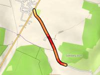
Your best attempt:
Climbed
Bucket list climb
Not yet climbed
Golksberg from Gelenau
0.7 mi
6.0%
42
213 ft
922 ft
5
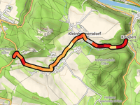
249
Your best attempt:
Climbed
Bucket list climb
Not yet climbed
Narrenkappe from Krippen
2.8 mi
5.1%
187
774 ft
1214 ft
3
250
Your best attempt:
Climbed
Bucket list climb
Not yet climbed
Am Breiteberg from Grossschönau
0.7 mi
6.7%
63
233 ft
1234 ft
5
Previous
Next
Your best attempt:
Climbed
Bucket list climb
Not yet climbed
a
This page is better in the app
Climbfinder
(Free)
Open