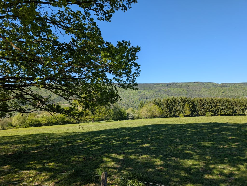
Côte de Xhierfomont is a climb in the region Valleys of the Vesdre, de l'Amblève et de l'Ourthe. It is 1.9 mi long and bridges 545 ft of vertical ascent with an average gradient of 5.5%, resulting in a difficulty score of 106. The top of the ascent is located at 1175 ft above sea level. Climbfinder users shared 22 reviews of this climb and uploaded 12 photos.
Road names: Xhierfomont & Meuville
4.0 by BerryVEThis is an automatic translation, the original language is: Dutch.Surely this is a funny climb. Nice runner and a few hairpin turns. Nowhere really steep so for everyone to do... read more
Welcome! Please activate your account if you would like to share something. Look for the verification email in your inbox.
If you want to upload your photos, you need to create an account. It only takes 1 minute and it's completely free.
Surely this is a funny climb. Nice runner and a few hairpin turns. Nowhere really steep so for everyone to do
Dit is toch wel een grappige beklimming. Mooie loper en een paar haarspeldbochten. Nergens echt stijl dus voor iedereen te doen
I love this. You come off the busy road and turn onto a small but good road. The first few kilometres zigzag through the forest, as you get to the top it becomes more open and at the top you have a nice view.
Ik hou hiervan. Je komt van de drukke weg en draait een kleine maar goede weg op. De eerste kilometers zigzaggen doorheen het bos, naarmate je meer boven komt wordt het meer open en bovenaan heb je een mooi uitzicht.
Very nice climb. Beforehand, the bike computer indicated quite steep sections at the hairpins, but it was over before you realised. A nice variation for those who want to suffer at the end: just before you leave Xhierformont, turn right. You then go along a very narrow asphalted path where you reach the 13% for another 400m. Those who still have the nerve to look to the right will also enjoy a nice view.
Hele mooie klim. Van te voren gaf de fietscomputer flink steile stukken aan bij de haarspeldbochten maar dat was over voor je het door had. Een leuke variatie voor hen die aan het eind nog even pijn willen leiden: sla net voor je Xhierformont uitrijdt af naar rechts. je gaat dan over een erg smal geasfalteerd pad waar je nog zo'n 400m de 13% aantikt. Wie dan nog over puf heeft om naar rechts te kijken geniet ook nog van een mooi uitzicht.
Bad road surface, but a climb like this'll make you quickly forget that. Climbing in peace, without really steep percentages, pure enjoyment!
Slecht wegdek, maar zo'n klim doet je dat snel vergeten. Klimmen in alle rust, zonder echt steile percentages, puur genieten!
Pretty fun climb :) Nice curves in a dense forest and then through a village and you end with a nice view. The last 600-800 metres are more of a spur than a climb, but still treacherous with the wind against you. You will encounter very little traffic I think, maybe some motorcyclists. And blame them with such'n bends ;)
Best leuke beklimming :) Leuke bochten in een dicht bos en daarna door een dorpje en je eindigt met een mooi uitzicht. De laatste 600-800 meter zijn meer een uitloper dan klim, maar met wind tegen alsnog verraderlijk. Je zult maar weinig verkeer tegenkomen denk ik, misschien wat motorrijders. En geef ze eens ongelijk met zo'n bochten ;)
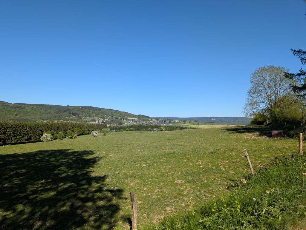
Three kilometres of climbing pleasure is what you get here. A nice run that does not get very difficult anywhere except for a few bits. The views over the valley are beautiful, enjoy!
Drie kilometer aan klimgenot is wat je hier voorgeschoteld krijgt. Een lekkere loper die op een paar stukjes na nergens erg moeilijk wordt. Het uitzicht over de vallei erg fraai, genieten!
Nice hairpins in the beginning, then some more straightforward. You feel just a bit more in 'the middle of nowhere' than many other climbs in the area.
Leuke haarspelden in het begin, dan wat meer rechttoe rechtaan. Je voelt je net wat meer in 'the middle of nowhere' dan vele andere beklimmingen in de buurt.
Nice gentle climb with hairpins in the forest. After the village, also beautiful views over the Amblève valley and the Ardennes. Nowhere really steep. Road surface not very good, but for a climb fine. At the top you can descend to Cheneux, for example, and then climb the Rosier via La Gleize or at Coo the Thier de Coo, largely avoiding the busier N633. Recently cycled on a trip along the Amblève with several cols.
Mooie rustige klim met haarspelden in het bos. Na het dorp ook prachtige uitzichten over de Amblève vallei en de Ardennen. Nergens echt steil. Wegdek niet heel goed, maar voor een klim prima. Boven kun je bijvoorbeeld afdalen naar Cheneux om daarna via La Gleize de Rosier te beklimmen of bij Coo de Thier de Coo, en zo grotendeels de wat drukkere N633 te vermijden. Recent nog gefietst tijdens een tocht langs de Amblève met meerdere cols.
Very pleasant climb, the bends make it even more fun, so you can wave to the men who come after you ;)
Zeer aangename beklimming, de bochten maken het nog extra leuk, zo kan je eens zwaaien naar de mannen die achter je komen ;)
Talk about a runner. A nice climb for in between. It doesn't get very steep, there are a few turns in the beginning (which always makes it more fun, I personally think) and the average is not too bad either. The climb is very gradual and you can, if you are strong enough, use a pretty big gear. What is annoying is that at the top it doesn't descend immediately, but you get stuck on a small plateau (depending on where you ride to, of course). And if you turn in the direction of Cheneux in Rahier (at the top), you get a bad descent where you can end up among the cows. A bit like Austria in Belgium.
Van een loper gesproken. Een leuke klim als tussendoortje. Hij wordt niet heel steil, er zitten een aantal bochten in aan het begin (wat het toch altijd leuker maakt, vind ik persoonlijk) en ook het gemiddelde valt best mee. De klim is zeer geleidelijk en je kan er, als je sterk genoeg bent, een best grote versnelling draaien. Wel vervelend is dat het boven niet direct daalt, maar dat je even op een plateautje blijft hangen (afhankelijk van naar waar je rijdt, natuurlijk). En als je in Rahier (op de top) richting Cheneux draait, krijg je een slechte afdaling waar je zomaar tussen de koeien terecht kan komen. Een beetje Oostenrijk in België.
Even with the lesser road surface I give it 5 stars, beautiful scenery, nice percentages and the hairpin bends finish it off.
Zelf met het mindere wegdek geef ik hem 5 sterren, mooie omgeving, mooie percentages en de haarspeldbochten maken het af.
Start of the climb through the beautiful valley of the Lienne. The steady gradient, a few hairpins and the woody environment make this climb one of the nicer ones in the area.
Aanloop richting de klim via de prachtige vallei van de Lienne. Het gelijkmatige stijgingspercentage, enkele haarspeldbochten en de bosrijke omgeving maken deze klim bij de mooiere uit de buurt.
Superb easy going climb. Hairpin bends, green. Enjoy.
Nice to alternate with the steep violence in the area.
Schitterend rustig lopende klim. Haarspeldbochten, groen. Genieten.
Mooi om af te wisselen met het steile geweld in de buurt.
Who climbs in the vicinity of Stoumont should definitely take this one. Not a tough climb but a real mountain feeling'by the hairpin bends at the start. The view from Xierfomont over the Amblève valley is also beautiful.
Wie in de buurt van Stoumont gaat klimmen moet deze er zeker eens bijnemen. Geen zware klim maar wel een echt 'berggevoel' door de haarspeldbochten bij de start. Het uitzicht vanuit Xierfomont over de Amblève vallei is ook prachtig.
Lovely climb that feels a bit heavier due to the bad road surface. As for the view, it is definitely worth it!
Heerlijke klim die net iets zwaarder voelt door het slechte wegdek. Qua uitzicht wel zeker en vast de moeite!
Last weekend I cycled it, it runs lovely and smooth without being too heavy. The exit is not after the bridge over the Lienne but after the bridge over the Ambleve.
Afgelopen weekend gefietst, loopt heerlijk continue zonder echt zwaar te worden. De afslag is overigens niet na de brug over de Lienne maar na de brug over de Ambleve.
Nice climb, but you can also turn right/straight for the last loop (because your route planner indicates that ;-))...and that's 200/250 meters double digit gradient. Guess it's at least 13-15%.
Mooie klim, maar je kunt ook voor de laatste lus (omdat je routeplanner dat aangeeft ;-)) rechtsaf/rechtdoor...en dat is 200/250 meter dubbel cijfers stijgingspercentage. Gok zeker tegen de 13-15%.
Nice climb with in the beginning real hairpin bends so you imagine yourself in the Alps. The road surface is very bad with large holes so pay attention, especially if you descend here. The climb is tough and runs long. Arrived at the top you have beautiful views and you can descend through Rahier on a beautiful road with good asphalt and fairly quiet.
Mooie klim met in het begin echte haarspeldbochten waardoor je je even in de Alpen waant. Het wegdek is erg slecht met grote gaten dus goed opletten, zeker als je hier daalt. De klim is pittig en loopt lang door. Boven aangekomen heb je prachtig uitzicht en kun je afdalen via Rahier over een prachtige weg met goed asfalt en vrij rustig.
Lovely climb with a fantastic view at the top. Then a beautiful descent towards Rosier sud (both asphalt and views)
Heerlijke klim met een fantastisch uitzicht op de top. Daarna een mooie afdaling richting Rosier sud (zowel asfalt als uitzicht)
Found this one of the most beautiful in this area. Feels a lot heavier than the percentages indicate, probably due to the bad road surface. After the top we were treated to a fantastic view on the road to Rahier.
Vond dit een van de mooiste in deze omgeving. Voelt een stuk zwaarder dan de percentages aangeven, vermoedelijk door het slechte wegdek. Na de top wel getrakteerd op een fantastisch uitzicht op de weg richting Rahier.
Did it once in a race, despite the suffering a very nice climb that is definitely worth it!
Heb hem eens in een wedstrijd gedaan, ondanks het afzien een erg mooie beklimming die zeker de moeite waard is!
| 5 mph | 00:22:33 |
| 7 mph | 00:15:57 |
| 9 mph | 00:12:26 |
| 12 mph | 00:09:20 |
This page is better in the app