View on map
© MapLibre | OpenStreetMap contributors
1%
2%
4%
6%
8%
10%
12%
15%
20%

Vlindersstraat

3.0
1 review/story | Elevation profile | 1 photo
Tips nearby
Vlindersstraat
transparant thumb
transparant thumb
transparant thumb
transparant thumb
transparant thumb
transparant thumb
transparant thumb
Your achievable time
Calculating based on your best performances...
Relaxed
Maximum
W/kg
W/kg
W/kg
Analyze your climbing performance
Detailed insight into your climbing performance & automatically check off climbs
Based on your best performances.
Your best attempt:
Number of attempts:
Elevation profile Vlindersstraat
paved
cobbles
paved

Statistics

Difficulty points 11
Length 0.9 mi
Average gradient 2.1%
Steepest segment 4.6%
Total ascent 95 ft

Short recap

Cobbles
#78 most elevation gain of Brussels-Capital Region
#21 longest climb of Brussels-Capital Region
Feedback about this climb?
Show climbs nearby Export to GPS device

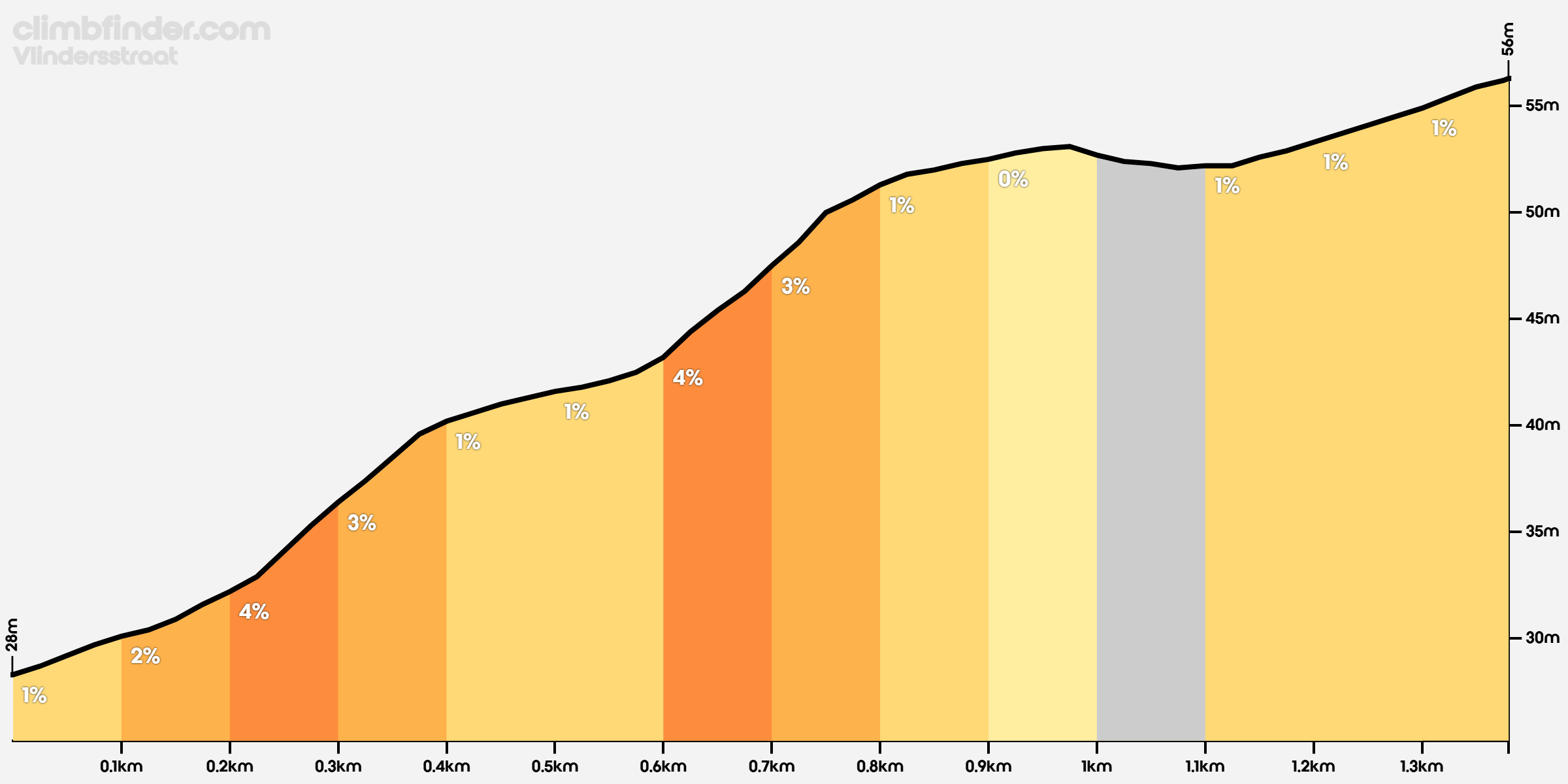
Vlindersstraat is a climb in the region Brussels-Capital Region. It is 0.9 mi long and bridges 95 ft of vertical ascent with an average gradient of 2.1%, resulting in a difficulty score of 11. The top of the ascent is located at 184 ft above sea level. Climbfinder users shared 1 review/story of this climb and uploaded 1 photo.

Road names: Rue de Scherdemael - Scherdemaalstraat, Rue des Papillons - Vlindersstraat & Rue du Pommier - Appelboomstraat
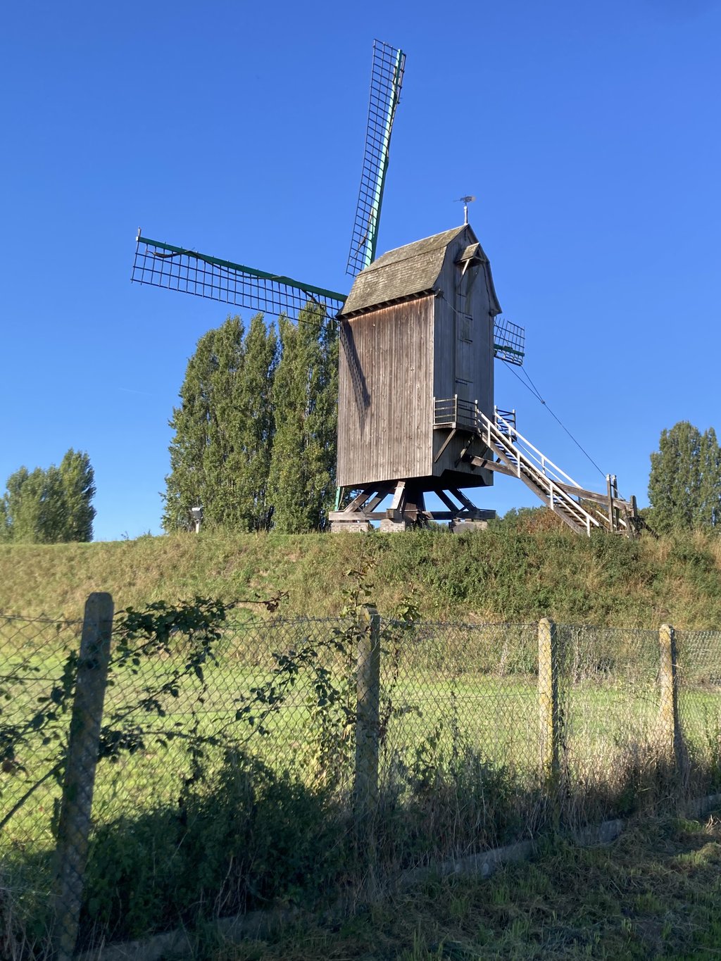
This is an automatic translation, the original language is: French.
A fairly long climb for the region, but a pleasant and surprisingly rural one on a narrow, little-travelled road linking the Neerpede ponds to Itterbeek. At the top, a windmill marks the end of the climb.... read more

Photos (1)

Vlindersstraat
transparant thumb
transparant thumb
transparant thumb
transparant thumb
transparant thumb

Your uploads (max 4)

Welcome! Please activate your account if you would like to share something. Look for the verification email in your inbox.

If you want to upload your photos, you need to create an account. It only takes 1 minute and it's completely free.

  • Receive free climbfinder goodies for your reviews & photos.
  • Create a bucket list and check off conquered climbs.
  • Add missing climbs.
Continue with GoogleContinue with Google Continue with FacebookContinue with Facebook Continue with AppleContinue with Apple Sign up with email
By signing up you agree to our terms of service and confirm that you have read our privacy & content policy.

Reviews (1)

5.0
4.0
3.0
2.0
1.0
Franck_Pastor
8 Mo 3.0
This is an automatic translation, the original language is: French. Show original

A fairly long climb for the region, but a pleasant and surprisingly rural one on a narrow, little-travelled road linking the Neerpede ponds to Itterbeek. At the top, a windmill marks the end of the climb.

Ascension assez longue pour la région, mais agréable et étonnamment champêtre sur une route étroite et peu fréquentée, joignant les étangs de Neerpede à Itterbeek. Au sommet, un moulin à vent signale la fin de la montée.

Vlindersstraat
Dashboard

Climbing times

5 mph 00:10:21
7 mph 00:07:19
9 mph 00:05:42
12 mph 00:04:17

Road surface condition

0% 100% 0%
Based on 1 vote
Share your knowledge. What was the road condition during your ascent?

Traffic

100% 0% 0%
Based on 1 vote
Your experience counts. How much traffic did you encounter during the climb?

Frequently Asked Questions

You don't need special gearing for Vlindersstraat. The slope isn't long or steep enough to require much shifting down. You can conquer this climb on power alone. However, a compact gearing system with a smallest front chainring of 34 and largest rear sprocket of 28 or 30 is always nice if you enjoy cycling uphill. This helps maintain a smooth cadence.

Vlindersstraat is not tough enough to be assigned a mountain category. This means that even untrained cyclists can reach the top without any problems on this climb.

Vlindersstraat is 0.9 mi long.

The average gradient of Vlindersstraat is 2.1%.

Vlindersstraat has a steepest segment with an average gradient of 4.6%.

The summit of Vlindersstraat is at 184 ft.

At a slow pace of 5 mph, it takes about 00:10:21 to climb Vlindersstraat. At 7 mph the time is 00:07:19, and at 9 mph 00:05:42. For the fastest cyclists, 00:04:17 is an achievable time.

Vlindersstraat is located in the region Brussels-Capital Region in Belgium.

This page is better in the app

Climbfinder app
Climbfinder
(Free)
Open