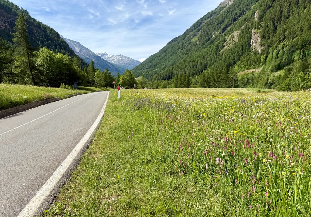
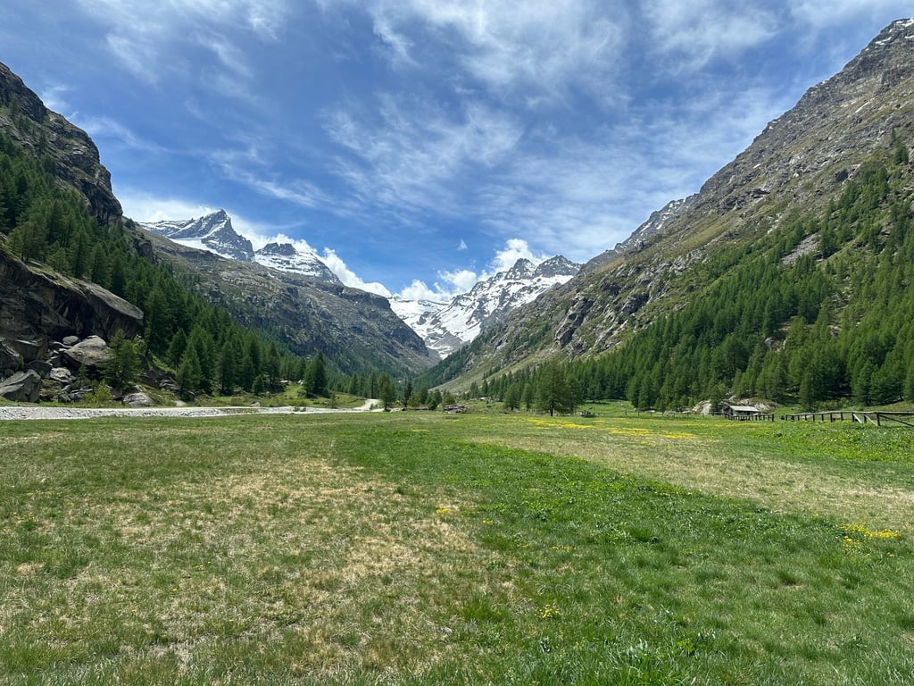
Valsavarenche is a climb in the region Aosta Valley. It is 15.9 mi long and bridges 4137 ft of vertical ascent with an average gradient of 4.9%, resulting in a difficulty score of 780. The top of the ascent is located at 6430 ft above sea level. Climbfinder users shared 9 reviews of this climb and uploaded 13 photos.
This is an automatic translation, the original language is: English.
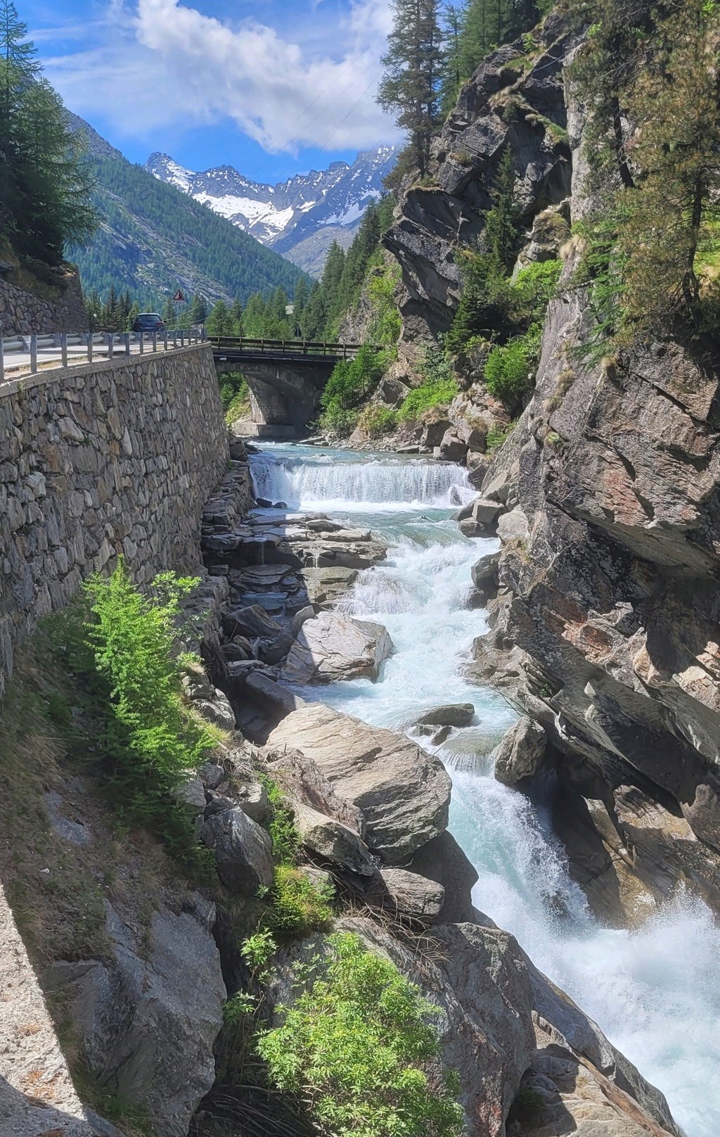
Very nice climb, a bit irregular but never too steep. As mentioned by others, the quality of the road is not great: in the descent you rally have to pay attention to the road. Some parts have recently been resurfaced, and some road works are in progress (september '25). The views are great, looking to the river with some waterfalls on the right, followed by a view of a glacier(?) in front. ...read more
Photos (13)
Welcome! Please activate your account if you would like to share something. Look for the verification email in your inbox.
This is an automatic translation, the original language is: Dutch.
Show original
Beautiful climb. There are a number of tunnels in the first section, so lights with you. Uneven climb, so gradients are sometimes higher than the elevation chart shows. Up to 10%.
Prachtige klim. In het eerste deel zitten een aantal tunnels, dus lampjes mee. Ongelijkmatige klim, waardoor stijgingspercentages soms hoger zijn dan de hoogtegrafiek toont. Tot 10%.
easier climb in the Aosta valley. quiet double lane road, frequently next to raging river with crystal clear water. many flat sections with couple short downhills. several tunnels, longest about 450m. lovely open plateau at the top at start of trail for hikers. no traffic on a thursday morning 4/6/26.
This is an automatic translation, the original language is: Italian.
Show original
Climbed yesterday May 24, 2026 starting from Introd (I came down from Les Combes) Really nice. Very little traffic, asphalt in good condition, slopes for long stretches very rideable. The valley is quite cool and the views are spectacular. The real difficulty lies in the length around 23 km.
Salita fatta ieri 24 maggio 2026 partendo da Introd (sono sceso da Les Combes) Davvero bella. Pochissimo traffico, asfalto in buone condizioni, pendenze per lunghi tratti molto pedalabili. La valle è abbastanza fresca e la vista è spettacolare. La vera difficoltà sta nella lunghezza intorno ai 23 km
Very nice climb, a bit irregular but never too steep. As mentioned by others, the quality of the road is not great: in the descent you rally have to pay attention to the road. Some parts have recently been resurfaced, and some road works are in progress (september '25). The views are great, looking to the river with some waterfalls on the right, followed by a view of a glacier(?) in front.
This is an automatic translation, the original language is: Italian.
Show original
An ascent through a majestic valley (personally my favourite), without ever reaching exaggerated gradients; it is long but rideable, and for this reason you can fully enjoy the nature in which it unfolds.
With the exception of the high season, there is almost never any traffic, although you may come across a few campers, which can be a nuisance on the descent.
If you tackle the climb at times of the year when there is not an exaggerated influx of tourists, it can happen, as I did, to have pleasant encounters with ibexes and chamois that have descended to road level.
Salita che si sviluppa in una valle maestosa (personalmente la mia preferita), senza mai raggiungere pendenze esagerate; è lunga ma pedalabile e per questo riesce a gustare pienamente la natura in cui si sviluppa.
Tolta l'altissima stagione non c'è quasi mai traffico anche se può capitare di incrociare qualche camper che in discesa può procurare noia.
Se si affronta la salita in periodi dell'anno con afflusso turistico non esagerato può capitare, come al sottoscritto di fare piacevoli incontri con stambecchi e camosci scesi fino al livello della strada.
This is an automatic translation, the original language is: Dutch.
Show original
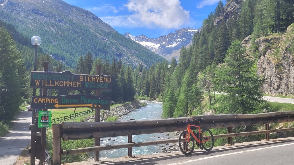
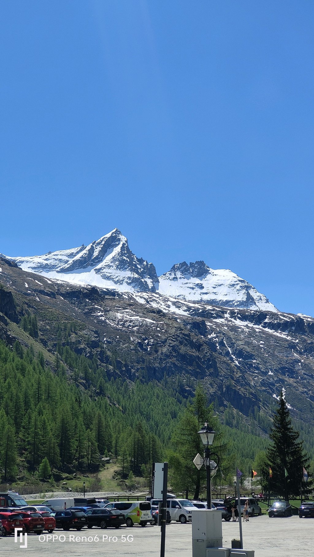
One of the beautiful mountain rides from the Aosta valley. Once you start climbing up along the river after Introd in the valley, it's a long runner, interspersed with steep sections. It's more the length that draws you blank than the steepness. You are rewarded with beautiful views, with the Gran Paradiso at the end of the road as a dessert.
Less crowded than the Grand St. Bernard or Cogne, and no work traffic, but in Italy you rarely escape in July / August on this kind of mountain roads to streams of cars's.
Eén van de mooie bergritten vanuit de Aosta vallei. Zodra je na Introd in het dal langs de rivier omhoog begint te klimmen, is het een lange loper, afgewisseld met steile stukken. Het is meer de lengte die je leeg trekt dan de steilheid. Je wordt beloond op fraaie vergezichten, met als toetje de Gran Paradiso op het einde van de weg.
Minder druk dan de Grand St. Bernard of Cogne, en geen werkverkeer, maar in Italië ontsnap je zelden in juli/augustus op dit soort bergwegen aan stromen auto's.
This is an automatic translation, the original language is: Dutch.
Show original
Done it yesterday, together with my wife. super nice climb really worth it! and to do! One detail, the climb is 26km long (not 23,9) measured from the roundabout (start SR23) to the end of the road (ferry). And good to know... the last 3 km has several parts of over 9%. But once at the top, the valley of Pont is FANTASTIC! So just do it!
gisteren gedaan, samen met mijn vrouw. super mooie klim echt de moeite waard! en te doen! Wel een detail.. de klim is 26km lang (niet 23,9) gemeten vanaf de rotonde (start SR23) tot en met het einde van de weg (pont). En goed om te weten.. de laatste 3 km kent nog verschillende stukjes van boven de 9%. Maar eenmaal boven is het dal van Pont FANTASTICH! Dus gewoon doen!
Share your knowledge. What was the road condition during your ascent?
Traffic
62% 38% 0%
Based on 13 votes
Your experience counts. How much traffic did you encounter during the climb?
Frequently Asked Questions
You don't need special gearing for Valsavarenche. The slope isn't long or steep enough to require much shifting down. You can conquer this climb on power alone. However, a compact gearing system with a smallest front chainring of 34 and largest rear sprocket of 28 or 30 is always nice if you enjoy cycling uphill. This helps maintain a smooth cadence.
Valsavarenche is a first-category climb: long and tough. Do not underestimate this climb. Many famous Tour de France cols fall into this category. Prepare for a long, challenging ride. Only well-trained riders will reach the top smoothly. Make sure you have a road bike with climbing gears and enough training; otherwise, it will be a struggle.
Valsavarenche is 15.9 mi long.
The average gradient of Valsavarenche is 4.9%.
Valsavarenche has a steepest segment with an average gradient of 11.3%.
The summit of Valsavarenche is at 6430 ft.
At a slow pace of 5 mph, it takes about 03:11:40 to climb Valsavarenche. At 7 mph the time is 02:15:42, and at 9 mph 01:45:45. For the fastest cyclists, 01:19:27 is an achievable time.