View on map
© MapLibre | OpenStreetMap contributors
1%
2%
4%
6%
8%
10%
12%
15%
20%

Vall d'Incles from Soldeu

2.0
1 review/story | Elevation profile | 1 photo
Tips nearby
Vall d'Incles from Soldeu
transparant thumb
transparant thumb
transparant thumb
transparant thumb
transparant thumb
transparant thumb
transparant thumb
Your achievable time
Calculating based on your best performances...
Relaxed
Maximum
W/kg
W/kg
W/kg
Analyze your climbing performance
Detailed insight into your climbing performance & automatically check off climbs
Based on your best performances.
Your best attempt:
Number of attempts:
Elevation profile Vall d'Incles from Soldeu

Statistics

Difficulty points 41
Length 1.9 mi
Average gradient 3%
Steepest segment 7.7%
Total ascent 299 ft
Feedback about this climb?
Show climbs nearby Export to GPS device

Vall d'Incles from Soldeu is a climb in the region Parishes of Andorra. It is 1.9 mi long and bridges 299 ft of vertical ascent with an average gradient of 3%, resulting in a difficulty score of 41. The top of the ascent is located at 6030 ft above sea level. Climbfinder users shared 1 review/story of this climb and uploaded 1 photo.

Road names: Carretera de la Vall d'Incles
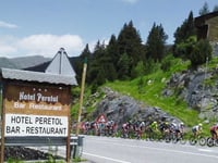
2.0 by Morellino
This is an automatic translation, the original language is: Dutch.
If you are in the area, be sure to do this climb that is not really a climb at all, as it is all very little in terms of percentages. In fact, you ride into a beautiful valley and end at a cosy tavern where hikers and cyclists meet. You can also get there by car and park because the 'summit' is the start of several hiking trails. The road is narrow and fairly busy with hikers, cars's and cyclists. There is quite a bit of gravel and gravel in some places but it is doable on a ro... read more

Photos (1)

Vall d'Incles from Soldeu
transparant thumb
transparant thumb
transparant thumb
transparant thumb
transparant thumb

Your uploads (max 4)

Welcome! Please activate your account if you would like to share something. Look for the verification email in your inbox.

If you want to upload your photos, you need to create an account. It only takes 1 minute and it's completely free.

  • Receive free climbfinder goodies for your reviews & photos.
  • Create a bucket list and check off conquered climbs.
  • Add missing climbs.
Continue with GoogleContinue with Google Continue with FacebookContinue with Facebook Continue with AppleContinue with Apple Sign up with email
By signing up you agree to our terms of service and confirm that you have read our privacy & content policy.

Reviews (1)

5.0
4.0
3.0
2.0
1.0
Morellino
1 y 2.0
This is an automatic translation, the original language is: Dutch. Show original

If you are in the area, be sure to do this climb that is not really a climb at all, as it is all very little in terms of percentages. In fact, you ride into a beautiful valley and end at a cosy tavern where hikers and cyclists meet.

You can also get there by car and park because the 'summit' is the start of several hiking trails. The road is narrow and fairly busy with hikers, cars's and cyclists. There is quite a bit of gravel and gravel in some places but it is doable on a road bike. I rewarded myself with a delicious beer and a fantastic view.

Als je in de buurt bent, doe dan zeker deze beklimming die eigenlijk geen beklimming is, omdat het allemaal weinig voorstelt qua percentages. Je rijdt namelijk een prachtige vallei in en eindigt bij een gezellige uitspanning waar wandelaars en fietsers elkaar treffen.

Je kunt er ook met de auto komen en parkeren want de 'top' is het begin van verschillende wandelroutes. De weg is smal en redelijk druk met wandelaars, auto's en fietsers. Er ligt behoorlijk wat grind en gravel op sommige plaatsen maar het is goed te doen met de racefiets. Ik beloonde mijzelf met een heerlijk biertje en een fantastisch uitzicht.

Dashboard

Climbing times

5 mph 00:22:26
7 mph 00:15:53
9 mph 00:12:23
12 mph 00:09:18

Road surface condition

100% 0% 0%
Based on 1 vote
Share your knowledge. What was the road condition during your ascent?

Traffic

50% 0% 50%
Based on 2 votes
Your experience counts. How much traffic did you encounter during the climb?

Frequently Asked Questions

You don't need special gearing for Vall d'Incles from Soldeu. The slope isn't long or steep enough to require much shifting down. You can conquer this climb on power alone. However, a compact gearing system with a smallest front chainring of 34 and largest rear sprocket of 28 or 30 is always nice if you enjoy cycling uphill. This helps maintain a smooth cadence.

Vall d'Incles from Soldeu falls into the 5th category. With good fitness, you can ride it up with speed and power. If you have less training, shift down and climb smoothly.

Vall d'Incles from Soldeu is 1.9 mi long.

The average gradient of Vall d'Incles from Soldeu is 3%.

Vall d'Incles from Soldeu has a steepest segment with an average gradient of 7.7%.

The summit of Vall d'Incles from Soldeu is at 6030 ft.

At a slow pace of 5 mph, it takes about 00:22:26 to climb Vall d'Incles from Soldeu. At 7 mph the time is 00:15:53, and at 9 mph 00:12:23. For the fastest cyclists, 00:09:18 is an achievable time.

Vall d'Incles from Soldeu is located in the region Parishes of Andorra in Andorra.

This page is better in the app

Climbfinder app
Climbfinder
(Free)
Open