View on map
© MapLibre | OpenStreetMap contributors
1%
2%
4%
6%
8%
10%
12%
15%
20%

Terlindenweg from Kasteel Hoensbroek

2.3
4 reviews | Elevation profile | 10 photos
Tips nearby
Terlindenweg from Kasteel Hoensbroek
Your achievable time
Calculating based on your best performances...
Relaxed
Maximum
W/kg
W/kg
W/kg
Analyze your climbing performance
Detailed insight into your climbing performance & automatically check off climbs
Based on your best performances.
Your best attempt:
Number of attempts:
Elevation profile Terlindenweg from Kasteel Hoensbroek

Statistics

Difficulty points 5
Length 0.4 mi
Average gradient 2.4%
Steepest segment 4.7%
Total ascent 49 ft
Feedback about this climb?
Show climbs nearby Export to GPS device

Terlindenweg from Kasteel Hoensbroek is a climb in the region South Limburg. It is 0.4 mi long and bridges 49 ft of vertical ascent with an average gradient of 2.4%, resulting in a difficulty score of 5. The top of the ascent is located at 279 ft above sea level. Climbfinder users shared 4 reviews of this climb and uploaded 10 photos.

Road names: Klinkertstraat & Terlindenweg

3.0 by ScOgLiO
This is an automatic translation, the original language is: English.
3 stars because the castle is in my opinion really pretty, but other than that I almost struggle to call this a climb, barely more than false flat. Road surface is very good, at least!... read more

Photos (10)

Terlindenweg from Kasteel Hoensbroek
transparant thumb
transparant thumb

Your uploads (max 4)

Welcome! Please activate your account if you would like to share something. Look for the verification email in your inbox.

If you want to upload your photos, you need to create an account. It only takes 1 minute and it's completely free.

  • Receive free climbfinder goodies for your reviews & photos.
  • Create a bucket list and check off conquered climbs.
  • Add missing climbs.
Continue with GoogleContinue with Google Continue with FacebookContinue with Facebook Continue with AppleContinue with Apple Sign up with email
By signing up you agree to our terms of service and confirm that you have read our privacy & content policy.

Reviews (4)

5.0
4.0
3.0
2.0
1.0
ScOgLiO
1 Mo 3.0

3 stars because the castle is in my opinion really pretty, but other than that I almost struggle to call this a climb, barely more than false flat. Road surface is very good, at least!

Dashboard
YordiZ
1 y 2.0
This is an automatic translation, the original language is: Dutch. Show original

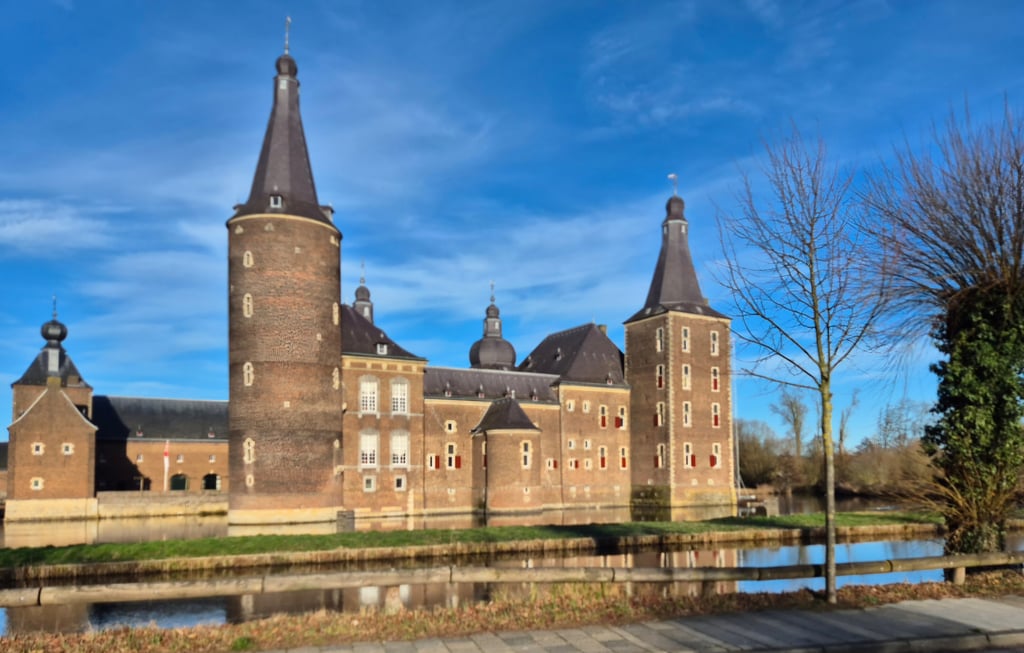
From Hoensbroek castle, the road starts to rise a bit. If you then turn into Terlindenweg, it gets a bit steeper. Still, nowhere is it really difficult. Apart from the beautiful castle at the foot, it is not really a nice climb otherwise.

Vanaf kasteel Hoensbroek begint de weg wat op te lopen. Als je vervolgens afslaat de Terlindenweg in dan wordt het een beetje steiler. Toch is het nergens echt lastig. Buiten het mooie kasteel aan de voet is het verder ook niet echt een mooie klim.

Dashboard
BikerJohan
1 y 2.0
This is an automatic translation, the original language is: Dutch. Show original

The climb starts on the outbound road from Hoensbroek to the area south of the A-76 between Voerendaal and Wijnandsrade. Before turning right, the road rises slightly and you have to be especially careful of the road narrows/traffic inhibitors. At the first houses on the right of the road, the steepest part of the climb begins. This continues almost to the end until just before the A-76 viaduct. You can take the climb if you come from the direction of Amstenrade/Vaesrade. However, there are less crowded and nicer alternatives nearby to get to the south side of the A-76.

De klim begint op de uitgaande weg van Hoensbroek naar het gebied ten zuiden van de A-76 tussen Voerendaal en Wijnandsrade. Voordat de weg rechtsaf gaat loopt de weg licht op en is het vooral oppassen voor de wegversmallingen/verkeersremmers. Bij de eerste huizen rechts van de weg begint het steilste deel van de klim. Dit loopt nagenoeg tot het einde door tot vlak voor het viaduct van de A-76. Je kan de klim meenemen als je uit de richting Amstenrade/Vaesrade komt. Er zijn in de buurt echter minder drukke en leukere alternatieven om aan de zuidkant van de A-76 te komen.

Dashboard
Fedor
2 y 2.0
This is an automatic translation, the original language is: Dutch. Show original

Climb along a branch road starting at the beautiful and impressive Kasteel Hoensbroek. The road goes up slightly, flattens out for a while and then really goes up. This section can be tricky cycling when it is busy, due to the road narrowing. At the end, turn right and then follow the further uphill road to the viaduct. After the climb, you enter beautiful countryside. Detour for this? To see the castle for sure but the climb is very relaxed. But as mentioned, it's a good shortcut.

Klimmetje over een uitvalsweg die begint bij het fraaie en indrukwekkende Kasteel Hoensbroek. De weg gaat lichtjes omhoog, vlakt even af en gaat daarna echt omhoog. Dit deel kan lastig fietsen zijn als het druk is, vanwege de wegversmallingen. Op het eind rechtsaf en daarna de verder stijgende weg naar het viaduct volgen. Na de klim kom je in mooi buitengebied. Omrijden hiervoor? Om het kasteel te zien zeker maar de klim is wel erg relaxed. Maar zoals gezegd is het een goede uitvalsweg.

Terlindenweg from Kasteel Hoensbroek
Dashboard

Climbing times

5 mph 00:04:39
7 mph 00:03:18
9 mph 00:02:34
12 mph 00:01:56

Road surface condition

100% 0% 0%
Based on 1 vote
Share your knowledge. What was the road condition during your ascent?

Traffic

0% 100% 0%
Based on 1 vote
Your experience counts. How much traffic did you encounter during the climb?

Frequently Asked Questions

You don't need special gearing for Terlindenweg from Kasteel Hoensbroek. The slope isn't long or steep enough to require much shifting down. You can conquer this climb on power alone. However, a compact gearing system with a smallest front chainring of 34 and largest rear sprocket of 28 or 30 is always nice if you enjoy cycling uphill. This helps maintain a smooth cadence.

Terlindenweg from Kasteel Hoensbroek is not tough enough to be assigned a mountain category. This means that even untrained cyclists can reach the top without any problems on this climb.

Terlindenweg from Kasteel Hoensbroek is 0.4 mi long.

The average gradient of Terlindenweg from Kasteel Hoensbroek is 2.4%.

Terlindenweg from Kasteel Hoensbroek has a steepest segment with an average gradient of 4.7%.

The summit of Terlindenweg from Kasteel Hoensbroek is at 279 ft.

At a slow pace of 5 mph, it takes about 00:04:39 to climb Terlindenweg from Kasteel Hoensbroek. At 7 mph the time is 00:03:18, and at 9 mph 00:02:34. For the fastest cyclists, 00:01:56 is an achievable time.

Terlindenweg from Kasteel Hoensbroek is located in the region Limburg in Netherlands.

This page is better in the app

Climbfinder app
Climbfinder
(Free)
Open