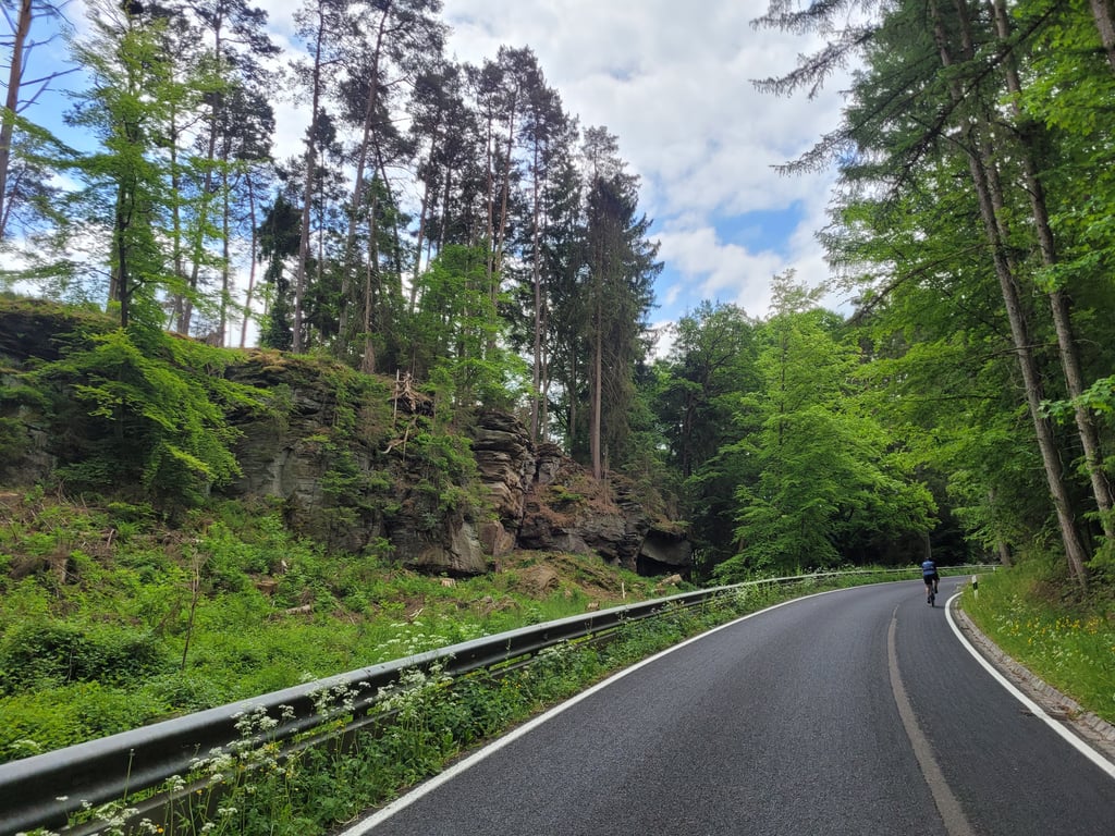
View on map
© MapLibre | OpenStreetMap contributors
1%
2%
4%
6%
8%
10%
12%
15%
20%

Supp from Dillingen via Route de Beaufort

3.5
4 reviews | Elevation profile | 6 photos
Tips nearby
Supp from Dillingen via Route de Beaufort
transparant thumb
transparant thumb
Your achievable time
Calculating based on your best performances...
Relaxed
Maximum
W/kg
W/kg
W/kg
Analyze your climbing performance
Detailed insight into your climbing performance & automatically check off climbs
Based on your best performances.
Your best attempt:
Number of attempts:
Elevation profile Supp from Dillingen via Route de Beaufort

Statistics

Difficulty points 125
Length 3 mi
Average gradient 4.8%
Steepest segment 7%
Total ascent 764 ft

Short recap

2 hairpin turns
#10 toughest climb of Mullerthal / Little Switzerland
#57 most elevation gain of Luxembourg
#39 longest climb of Luxembourg
#64 average steepest climb of Mullerthal / Little Switzerland
Feedback about this climb?
Show climbs nearby Export to GPS device

Supp from Dillingen via Route de Beaufort is a climb in the region Mullerthal / Little Switzerland. It is 3 mi long and bridges 764 ft of vertical ascent with an average gradient of 4.8%, resulting in a difficulty score of 125. The top of the ascent is located at 1348 ft above sea level. Climbfinder users shared 4 reviews of this climb and uploaded 6 photos.

Road name: Route de Beaufort, Chemin des Romains, Route de Reisdorf

4.0 by Jeroen
This is an automatic translation, the original language is: Dutch.
Nice climb if you're a bit done with all those walls to bump your head against. You get two hairpin bends in return. The climb is not heavy, but goes through a beautiful forest with rocks. The road surface is superfantastic.... read more

Photos (6)

Supp from Dillingen via Route de Beaufort

Your uploads (max 4)

Welcome! Please activate your account if you would like to share something. Look for the verification email in your inbox.

If you want to upload your photos, you need to create an account. It only takes 1 minute and it's completely free.

  • Receive free climbfinder goodies for your reviews & photos.
  • Create a bucket list and check off conquered climbs.
  • Add missing climbs.
Continue with GoogleContinue with Google Continue with FacebookContinue with Facebook Continue with AppleContinue with Apple Sign up with email
By signing up you agree to our terms of service and confirm that you have read our privacy & content policy.

Reviews (4)

5.0
4.0
3.0
2.0
1.0
Jarin
1 y 4.0 via the Climbfinder app
This is an automatic translation, the original language is: Dutch. Show original

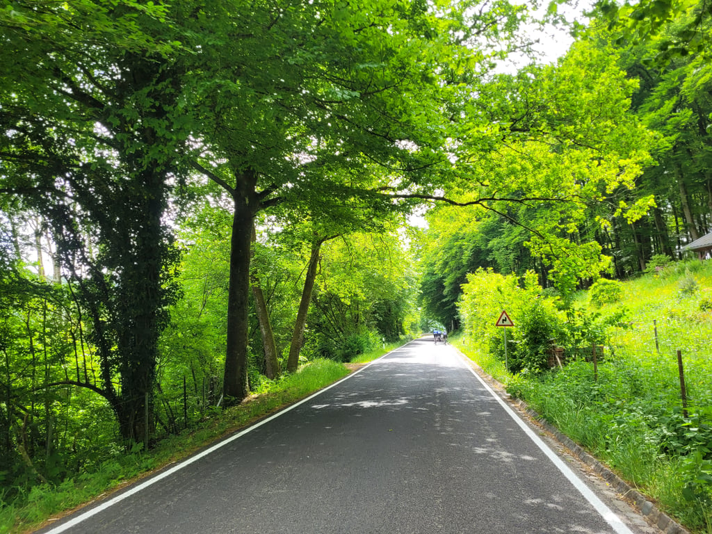
Long continuous climb with a number of bends. In the forest, you pass a number of rock faces characteristic of the Mueller Valley.

Lang soorlopende klim met een aantal bochten. In het bos kom je langs een aantal rotswanden die karakteristiek zijn voor het Muellertal.

Supp from Dillingen via Route de Beaufort
Dashboard
YordiZ
2 y 3.0
This is an automatic translation, the original language is: Dutch. Show original

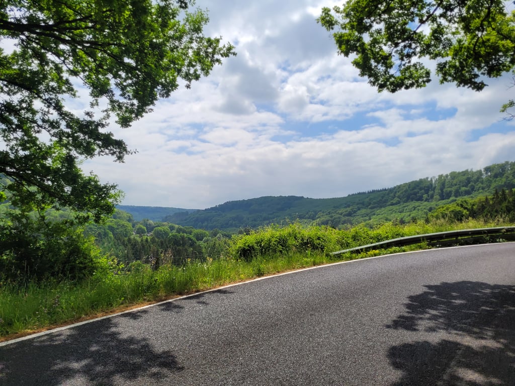
On a narrow road you climb here mostly through the forest towards Beaufort. If you're looking for rhythm at the bottom, you'll definitely come out well here. Don't expect any views, at most some rocks along the way.

Over een smalle weg klim je hier veelal door het bos richting Beaufort. Zoek je ritme onderaan dan kom je hier zeker goed boven. Verwacht geen uitzichten, hooguit wat rotsen langs de weg.

Dashboard
JeroenKaspers
3 y 3.0
This is an automatic translation, the original language is: Dutch. Show original

Beautiful surroundings for cycling, where you'd better take this climb with you. Nice runner, never really heavy, but over this beautiful tarmac and little traffic super nice!
Also nice in the descent by the way!

Prachtige omgeving om te fietsen, waar je deze klim dan toch beter even meepakt. Mooie loper, nooit écht zwaar, maar over dit mooie asfalt en weinig verkeer wel super nice!
Ook leuk in de afdaling trouwens!

Supp from Dillingen via Route de Beaufort
Dashboard
Jeroen
4 y 4.0
This is an automatic translation, the original language is: Dutch. Show original

Nice climb if you're a bit done with all those walls to bump your head against. You get two hairpin bends in return. The climb is not heavy, but goes through a beautiful forest with rocks. The road surface is superfantastic.

Leuke klim als je een beetje klaar bent met al die muren om je hoofd tegen te stoten. Je krijgt er twee haarspeldbochten voor terug. De klim is niet zwaar, maar loopt door een prachtig bos met rotspartijen. Het wegdek is supertopfantastisch.

Supp from Dillingen via Route de Beaufort
Dashboard

Climbing times

5 mph 00:36:27
7 mph 00:25:48
9 mph 00:20:06
12 mph 00:15:06

Road surface condition

100% 0% 0%
Based on 4 votes
Share your knowledge. What was the road condition during your ascent?

Traffic

100% 0% 0%
Based on 4 votes
Your experience counts. How much traffic did you encounter during the climb?

Frequently Asked Questions

Supp can be cycled from 3 sides. Supp from Dillingen via Route de Beaufort is the most popular side, but the summit can also be reached via Supp from Dillingen via Chemin des Sources & Supp from Reisdorf.

You don't need special gearing for Supp from Dillingen via Route de Beaufort. The slope isn't long or steep enough to require much shifting down. You can conquer this climb on power alone. However, a compact gearing system with a smallest front chainring of 34 and largest rear sprocket of 28 or 30 is always nice if you enjoy cycling uphill. This helps maintain a smooth cadence.

Supp from Dillingen via Route de Beaufort is a 4th-category climb. A sprint to the top is usually not an option, and untrained riders will definitely feel it in their legs. For trained cyclists, it is a great training climb.

Supp from Dillingen via Route de Beaufort is 3 mi long.

The average gradient of Supp from Dillingen via Route de Beaufort is 4.8%.

Supp from Dillingen via Route de Beaufort has a steepest segment with an average gradient of 7%.

The summit of Supp from Dillingen via Route de Beaufort is at 1348 ft.

At a slow pace of 5 mph, it takes about 00:36:27 to climb Supp from Dillingen via Route de Beaufort. At 7 mph the time is 00:25:48, and at 9 mph 00:20:06. For the fastest cyclists, 00:15:06 is an achievable time.

Supp from Dillingen via Route de Beaufort is located in the region Mullerthal / Little Switzerland in Luxembourg.

This page is better in the app

Climbfinder app
Climbfinder
(Free)
Open