View on map
© MapLibre | OpenStreetMap contributors
1%
2%
4%
6%
8%
10%
12%
15%
20%

Rue de Richelle

3.0
5 reviews | Elevation profile | 9 photos
Tips nearby
Rue de Richelle
Rue de Richelle
Rue de Richelle
Rue de Richelle
Rue de Richelle
Rue de Richelle
Rue de Richelle
Rue de Richelle
Your achievable time
Calculating based on your best performances...
Relaxed
Maximum
W/kg
W/kg
W/kg
Analyze your climbing performance
Detailed insight into your climbing performance & automatically check off climbs
Based on your best performances.
Your best attempt:
Number of attempts:
Elevation profile Rue de Richelle

Statistics

Difficulty points 34
Length 0.8 mi
Average gradient 5.2%
Steepest segment 6.1%
Total ascent 217 ft

Short recap

2 hairpin turns
Feedback about this climb?
Show climbs nearby Export to GPS device

Rue de Richelle is a climb in the region Pays de Herve. It is 0.8 mi long and bridges 217 ft of vertical ascent with an average gradient of 5.2%, resulting in a difficulty score of 34. The top of the ascent is located at 400 ft above sea level. Climbfinder users shared 5 reviews of this climb and uploaded 9 photos.

Road name: Rue de Richelle
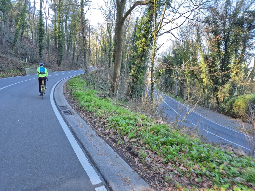
This is an automatic translation, the original language is: Dutch.
Good road surface, nice curves, nice constant rate and wooded area. Pity it is so crowded 6/10... read more

Photos (9)

Rue de Richelle
Rue de Richelle
Rue de Richelle
Rue de Richelle
Rue de Richelle
Rue de Richelle
Rue de Richelle
Rue de Richelle
Rue de Richelle
transparant thumb
transparant thumb
transparant thumb

Your uploads (max 4)

Welcome! Please activate your account if you would like to share something. Look for the verification email in your inbox.

If you want to upload your photos, you need to create an account. It only takes 1 minute and it's completely free.

  • Receive free climbfinder goodies for your reviews & photos.
  • Create a bucket list and check off conquered climbs.
  • Add missing climbs.
Continue with GoogleContinue with Google Continue with FacebookContinue with Facebook Continue with AppleContinue with Apple Sign up with email
By signing up you agree to our terms of service and confirm that you have read our privacy & content policy.

Reviews (5)

5.0
4.0
3.0
2.0
1.0
JurneSleddens
10 Mo 3.0
This is an automatic translation, the original language is: Dutch. Show original

Good road surface, nice curves, nice constant rate and wooded area. Pity it is so crowded 6/10

Goed wegdek, leuke bochten, lekker constant percentage en bosrijke omgeving. Jammer dat het er zo druk is 6/10

Dashboard
Fedor
1 y 3.0
This is an automatic translation, the original language is: Dutch. Show original

Excellent runner on a wonderfully winding link road with several hairpin bends and through a wooded area. Good tarmac but the road can be busy. The climb continues between buildings for a little longer (but slightly) than indicated.

Uitstekende loper over een heerlijk slingerende verbindingsweg met meerdere haarspeldbochten en door een bosrijke omgeving. Goed asfalt maar de weg kan wel druk zijn. De klim loopt tussen de bebouwing nog iets langer door (maar wel lichtjes) dan aangegeven.

Rue de Richelle
Rue de Richelle
Rue de Richelle
Rue de Richelle
Dashboard
_superver
2 y 2.0
This is an automatic translation, the original language is: Dutch. Show original

Nice climb with good tarmac, but a lot of traffic say.

Fraaie beklimming met goed asfalt, maar wel heel veel verkeer zeg.

Dashboard
PelotonDesArdennes
5 y 4.0
This is an automatic translation, the original language is: Dutch. Show original

Between Liege and Visé this is the easiest and at the same time the most beautiful way to climb out of the valley of the Meuse.
If you go straight on after the 2 hairpins or turn right, both are comparable. Just depends where you want to go after the climb.

Tussen Luik en Visé is dit de makkelijkste en tegelijk de mooiste manier om de maasvallei uit te klimmen.
Als je na de 2 haarspeldbochten rechtdoor gaat of rechtsaf draait, beide zijn vergelijkbaar. Hangt gewoon af waar je na de klim naartoe wil.

Dashboard
JulienWillems
5 y 3.0
This is an automatic translation, the original language is: Dutch. Show original

A must to leave the maasvalley. First few hundred meters is a straight road and therefore easy to follow. After that some unclear winding curves. Nice and even as the profile shows. Busier commuting traffic limits the charm somewhat.

Een aanrader om de maasvallei te verlaten. Eerste honderden meters een rechte weg en dus overzichtelijk. Daarna enkele onoverzichtelijke slingerbochten. Mooi gelijkmatig zoals het profiel laat zien. Drukker woon-/ werkverkeer beperkt de charme enigszins.

Rue de Richelle
Dashboard

Climbing times

5 mph 00:09:35
7 mph 00:06:47
9 mph 00:05:17
12 mph 00:03:58

Road surface condition

100% 0% 0%
Based on 5 votes
Share your knowledge. What was the road condition during your ascent?

Traffic

0% 40% 60%
Based on 5 votes
Your experience counts. How much traffic did you encounter during the climb?

Frequently Asked Questions

You don't need special gearing for Rue de Richelle. The slope isn't long or steep enough to require much shifting down. You can conquer this climb on power alone. However, a compact gearing system with a smallest front chainring of 34 and largest rear sprocket of 28 or 30 is always nice if you enjoy cycling uphill. This helps maintain a smooth cadence.

Rue de Richelle falls into the 5th category. With good fitness, you can ride it up with speed and power. If you have less training, shift down and climb smoothly.

Rue de Richelle is 0.8 mi long.

The average gradient of Rue de Richelle is 5.2%.

Rue de Richelle has a steepest segment with an average gradient of 6.1%.

The summit of Rue de Richelle is at 400 ft.

At a slow pace of 5 mph, it takes about 00:09:35 to climb Rue de Richelle. At 7 mph the time is 00:06:47, and at 9 mph 00:05:17. For the fastest cyclists, 00:03:58 is an achievable time.

Rue de Richelle is located in the region Liège Province in Belgium.

This page is better in the app

Climbfinder app
Climbfinder
(Free)
Open