View on map
© MapLibre | OpenStreetMap contributors
1%
2%
4%
6%
8%
10%
12%
15%
20%

Réotier from Saint Clément sur Durance

3.0
3 reviews | Elevation profile | 9 photos
Tips nearby
Réotier from Saint Clément sur Durance
Your achievable time
Calculating based on your best performances...
Relaxed
Maximum
W/kg
W/kg
W/kg
Analyze your climbing performance
Detailed insight into your climbing performance & automatically check off climbs
Based on your best performances.
Your best attempt:
Number of attempts:
Elevation profile Réotier from Saint Clément sur Durance

Statistics

Difficulty points 84
Length 1.3 mi
Average gradient 5.7%
Steepest segment 10.2%
Total ascent 384 ft

Short recap

2 hairpin turns
#83 toughest climb of Briançon
#77 most elevation gain of Briançon
#78 longest climb of Briançon
#73 average steepest climb of Briançon
Feedback about this climb?
Show climbs nearby Export to GPS device

Réotier from Saint Clément sur Durance is a climb in the region Briançon. It is 1.3 mi long and bridges 384 ft of vertical ascent with an average gradient of 5.7%, resulting in a difficulty score of 84. The top of the ascent is located at 3255 ft above sea level. Climbfinder users shared 3 reviews of this climb and uploaded 9 photos.

Road names: Route de Réotier & Route de Saint-Clément
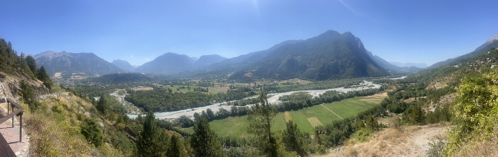
3.0 by TheoG65
This is an automatic translation, the original language is: French.
Nice climb with a nice view at the end, made after the Izoard.... read more

Photos (9)

Réotier from Saint Clément sur Durance
transparant thumb
transparant thumb
transparant thumb

Your uploads (max 4)

Welcome! Please activate your account if you would like to share something. Look for the verification email in your inbox.

If you want to upload your photos, you need to create an account. It only takes 1 minute and it's completely free.

  • Receive free climbfinder goodies for your reviews & photos.
  • Create a bucket list and check off conquered climbs.
  • Add missing climbs.
Continue with GoogleContinue with Google Continue with FacebookContinue with Facebook Continue with AppleContinue with Apple Sign up with email
By signing up you agree to our terms of service and confirm that you have read our privacy & content policy.

Reviews (3)

5.0
4.0
3.0
2.0
1.0
TheoG65
3 Mo 3.0 via the Climbfinder app
This is an automatic translation, the original language is: French. Show original

Nice climb with a nice view at the end, made after the Izoard.

Belle montée avec jolie vu à la fin, faites après l’Izoard

Réotier from Saint Clément sur Durance
Dashboard
Cromagnon
2 y 3.0
This is an automatic translation, the original language is: French. Show original

Nothing incredible, but a short and pleasant climb. In fact, the view is quite beautiful. Unfortunately, you still hear too many cars. Very good surface. And then, that Tour de France machine...

Rien d’incroyable mais petite ascension courte et sympa. Effectivement, la vue est plutôt belle. Hélas, on entend encore bien trop les voitures. Très bon revêtement. Et puis, cet engin du Tour de France…

Réotier from Saint Clément sur Durance
Dashboard
Rogier
5 y 3.0
This is an automatic translation, the original language is: Dutch. Show original

A nice climb away from the route national. A few hairpins and a nice view over the valley of the Durance and the Guil. Not very special, but always nice to include in a round trip in the area, and many times better than the RN which lies next to it.

Een leuke klim weg van de route national. Een paar haarspeldbochten en een mooi uitzicht over het dal van de Durance en de Guil. Niet heel bijzonder, maar altijd leuk om in een rondje in de buurt op te nemen, en vele malen beter dan de RN die ernaast ligt.

Dashboard

Climbing times

5 mph 00:15:18
7 mph 00:10:50
9 mph 00:08:26
12 mph 00:06:20

Road surface condition

100% 0% 0%
Based on 1 vote
Share your knowledge. What was the road condition during your ascent?

Traffic

100% 0% 0%
Based on 1 vote
Your experience counts. How much traffic did you encounter during the climb?

Frequently Asked Questions

Réotier can be cycled from 3 sides. Réotier from Saint Clément sur Durance is the most popular side, but the summit can also be reached via Réotier from Mont Dauphin & Réotier from Saint Thomas.

You don't need special gearing for Réotier from Saint Clément sur Durance. The slope isn't long or steep enough to require much shifting down. You can conquer this climb on power alone. However, a compact gearing system with a smallest front chainring of 34 and largest rear sprocket of 28 or 30 is always nice if you enjoy cycling uphill. This helps maintain a smooth cadence.

Réotier from Saint Clément sur Durance is a 4th-category climb. A sprint to the top is usually not an option, and untrained riders will definitely feel it in their legs. For trained cyclists, it is a great training climb.

Réotier from Saint Clément sur Durance is 1.3 mi long.

The average gradient of Réotier from Saint Clément sur Durance is 5.7%.

Réotier from Saint Clément sur Durance has a steepest segment with an average gradient of 10.2%.

The summit of Réotier from Saint Clément sur Durance is at 3255 ft.

At a slow pace of 5 mph, it takes about 00:15:18 to climb Réotier from Saint Clément sur Durance. At 7 mph the time is 00:10:50, and at 9 mph 00:08:26. For the fastest cyclists, 00:06:20 is an achievable time.

Réotier from Saint Clément sur Durance is located in the region Hautes Alpes in France.

This page is better in the app

Climbfinder app
Climbfinder
(Free)
Open