Prinsenbos from Assent is a climb in the region Hageland. It is 0.1 mi long and bridges 72 ft of vertical ascent with an average gradient of 10.7%, resulting in a difficulty score of 24. The top of the ascent is located at 197 ft above sea level. Climbfinder users shared 4 reviews of this climb and uploaded 1 photo.
This is an automatic translation, the original language is: Dutch.
I drove up this climb via the stone road from Assent. Now you have a lane in the middle of the stone road to turn left. Timing does remain important if you don't want to start the climb quietly.
The climb starts off briskly right away. I was able to do the whole climb "en danseuse" without stalling. However, it is nowhere too steep where you can stop and not too long either.
Today it was also terribly hot, but with this climb you are under the shade of the trees the whole time.
...read more
Photos (1)
Welcome! Please activate your account if you would like to share something. Look for the verification email in your inbox.
This is an automatic translation, the original language is: Dutch.
Show original
I drove up this climb via the stone road from Assent. Now you have a lane in the middle of the stone road to turn left. Timing does remain important if you don't want to start the climb quietly.
The climb starts off briskly right away. I was able to do the whole climb "en danseuse" without stalling. However, it is nowhere too steep where you can stop and not too long either.
Today it was also terribly hot, but with this climb you are under the shade of the trees the whole time.
Ranked 3rd in Flemish Brabant for average steepest gradient and 19th in Flanders. However, it is not a slope to be afraid of.
Ik reed deze klim aan via de steenweg vanuit Assent. Nu heb je een voorsorteerstrook in het midden van de steenweg om linksaf te slaan. Timing blijft wel belangrijk als je niet stil wilt beginnen aan de klim.
De klim begint meteen stevig. Ik heb de hele klim "en danseuse" kunnen doen zonder stil te vallen. Hij is echter nergens te steil waar je kan stilvallen en ook niet té lang.
Vandaag was het ook verschrikkelijk warm, maar bij deze klim zit je de hele tijd onder de schaduw van de bomen.
Staat in Vlaams-Brabant op de 3e plaats van gemiddeld steilste helling en 19e in Vlaanderen. Het is echter geen helling om bang voor te hebben.
This is an automatic translation, the original language is: Dutch.
Show original
Punishing thing! Nice to suddenly encounter such'a steep pustule, didn't expect 'm. As Steven points out, you start almost from standstill, which makes 'm tougher. It is short enough to just go full throttle. Recommended if you're in the area!
Straf ding! Leuk om ineens zo'n steile puist tegen te komen, had 'm niet verwacht. Zoals Steven aangeeft begin je vrijwel uit stilstand, dat maakt 'm zwaarder. Hij is kort genoeg om gewoon lekker voluit te gaan. Aanrader als je in de buurt bent!
This is an automatic translation, the original language is: Dutch.
Show original
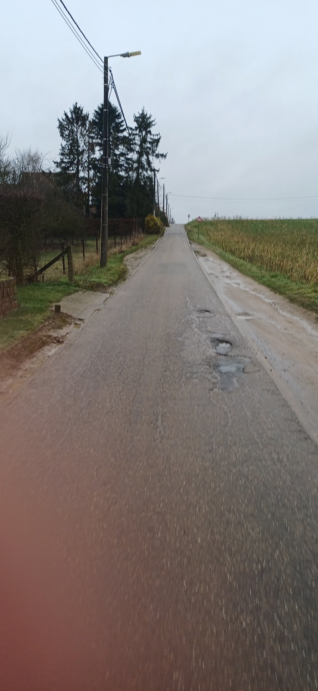
The Prinsenbos is one of the steeper climbs in the region. The start of this slope is along a very busy traffic road. This means that you often have to start this climb from quasi standstill, unless you are lucky with the crossing traffic. Consequently, it makes the Prinsenbos all the more explosive, a real punch!
The state of the road surface doesn't really help. The concrete slabs need replacing: they show cracks, and in some places there are even real craters in the road surface (especially on the right side). Fortunately for many, this climb is too steep both up and down, which makes it consequently quiet.
The official Strava segment is 270m long at an average of 9.8%. This is because part of the spur on the plateau is included in the climb. Here the wind can seriously blow at a disadvantage....
De Prinsenbos is één van de steilere beklimmingen van de regio. Het begin van deze helling ligt langs een zeer drukke verkeersweg. Dat maakt dat je deze klim vaak vanuit quasi stilstand moet aanvatten, tenzij je geluk hebt met het kruisende verkeer. Bijgevolg maakt het de Prinsenbos des te explosiever, een heuse punch!
De staat van het wegdek helpt niet echt. De betonplaten zijn aan vervanging toe: ze vertonen scheuren, en op sommige plekken zijn er zelfs heuse kraters in het wegdek (vooral aan de rechterzijde). Gelukkig is deze klim voor velen té steil zowel in stijgende als dalende lijn, wat maakt dat het er bijgevolg rustig is.
Het officiële Strava-segment is 270m lang aan een gemiddelde van 9.8%. Dat komt omdat een deel van de uitloper op het plateau is meegenomen in de beklimming. Hier kan de wind serieus in het nadeel blazen....
Share your knowledge. What was the road condition during your ascent?
Traffic
67% 33% 0%
Based on 6 votes
Your experience counts. How much traffic did you encounter during the climb?
Frequently Asked Questions
You don't need special gearing for Prinsenbos from Assent. The slope isn't long or steep enough to require much shifting down. You can conquer this climb on power alone. However, a compact gearing system with a smallest front chainring of 34 and largest rear sprocket of 28 or 30 is always nice if you enjoy cycling uphill. This helps maintain a smooth cadence.
Prinsenbos from Assent is not tough enough to be assigned a mountain category. This means that even untrained cyclists can reach the top without any problems on this climb.
Prinsenbos from Assent is 0.1 mi long.
The average gradient of Prinsenbos from Assent is 10.7%.
Prinsenbos from Assent has a steepest segment with an average gradient of 12.7%.
The summit of Prinsenbos from Assent is at 197 ft.
At a slow pace of 5 mph, it takes about 00:01:32 to climb Prinsenbos from Assent. At 7 mph the time is 00:01:05, and at 9 mph 00:00:51. For the fastest cyclists, 00:00:38 is an achievable time.