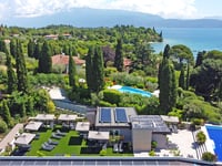
View on map
© MapLibre | OpenStreetMap contributors
1%
2%
4%
6%
8%
10%
12%
15%
20%

Passo del Ballino from Riva del Garda via Tenno

3.3
3 reviews | Elevation profile | 4 photos
Tips nearby
Passo del Ballino from Riva del Garda via Tenno
transparant thumb
transparant thumb
transparant thumb
transparant thumb
Your achievable time
Calculating based on your best performances...
Relaxed
Maximum
W/kg
W/kg
W/kg
Analyze your climbing performance
Detailed insight into your climbing performance & automatically check off climbs
Based on your best performances.
Your best attempt:
Number of attempts:
Elevation profile Passo del Ballino from Riva del Garda via Tenno

Statistics

Difficulty points 413
Length 9.8 mi
Average gradient 4.5%
Steepest segment 11.2%
Total ascent 2326 ft

Short recap

Beautiful scenery
11 hairpin turns
#72 longest climb of Trentino-South Tyrol
Feedback about this climb?
Show climbs nearby Export to GPS device

Passo del Ballino from Riva del Garda via Tenno is a climb in the region Trento. It is 9.8 mi long and bridges 2326 ft of vertical ascent with an average gradient of 4.5%, resulting in a difficulty score of 413. The top of the ascent is located at 2556 ft above sea level. Climbfinder users shared 3 reviews of this climb and uploaded 4 photos.

Road names: Viale degli Oleandri, Via Ballino, Via Nuova & Strada Statale 421 dei Laghi di Molveno e Tenno

This is an automatic translation, the original language is: Polish.
The climb except for the end holds the grade nicely. For much of it a pleasant view of Lago di Garda. Recommended!... read more

Photos (4)

Passo del Ballino from Riva del Garda via Tenno
transparant thumb
transparant thumb

Your uploads (max 4)

Welcome! Please activate your account if you would like to share something. Look for the verification email in your inbox.

If you want to upload your photos, you need to create an account. It only takes 1 minute and it's completely free.

  • Receive free climbfinder goodies for your reviews & photos.
  • Create a bucket list and check off conquered climbs.
  • Add missing climbs.
Continue with GoogleContinue with Google Continue with FacebookContinue with Facebook Continue with AppleContinue with Apple Sign up with email
By signing up you agree to our terms of service and confirm that you have read our privacy & content policy.

Reviews (3)

5.0
4.0
3.0
2.0
1.0
kwiatkowski_robert
10 Mo 4.0 via the Climbfinder app
This is an automatic translation, the original language is: Polish. Show original

The climb except for the end holds the grade nicely. For much of it a pleasant view of Lago di Garda. Recommended!

The climb except for the end holds the grade nicely. For much of it a pleasant view of Lago di Garda. Recommended!

Dashboard
EmaAmo
1 y 3.0 via the Climbfinder app
This is an automatic translation, the original language is: Italian. Show original

An ascent that is well worth it for the fantastic views of Lake Garda and the Sarca Valley. It alternates between steep and pedalable sections. Nice to include in other loop tours by combining it with the beautiful cycle paths in the area.

Salita che merita per i panorami fantastici sul Garda e sulla Valle del Sarca. Alterna strappi a tratti pedalabili. Bella da inserire in altri giri ad anello combinandola con le belle ciclabili della zona.

Dashboard
Cricelo75
2 y 3.0
This is an automatic translation, the original language is: Italian. Show original

Very even climb with a beautiful view of the lake in the first part. Excellent road surface. If you are in the area it is definitely worth a climb with a descent on the other side via Pranzo and Lago di Tenno.

Salita molto regolare con un bellissimo panorama del lago nella prima parte. Fondo stradale ottimo. Se si è in zona merita sicuramente una salita con discesa sull'altro versante passando da Pranzo e Lago di Tenno

Dashboard

Climbing times

5 mph 01:58:20
7 mph 01:23:46
9 mph 01:05:17
12 mph 00:49:03

Road surface condition

100% 0% 0%
Based on 2 votes
Share your knowledge. What was the road condition during your ascent?

Traffic

100% 0% 0%
Based on 2 votes
Your experience counts. How much traffic did you encounter during the climb?

Frequently Asked Questions

Passo del Ballino can be cycled from 3 sides. Passo del Ballino from Riva del Garda via Pranzo is the most popular side, but the summit can also be reached via Passo del Ballino from Riva del Garda via Tenno & Passo del Ballino from Ponte Arche.

You don't need special gearing for Passo del Ballino from Riva del Garda via Tenno. The slope isn't long or steep enough to require much shifting down. You can conquer this climb on power alone. However, a compact gearing system with a smallest front chainring of 34 and largest rear sprocket of 28 or 30 is always nice if you enjoy cycling uphill. This helps maintain a smooth cadence.

Passo del Ballino from Riva del Garda via Tenno is a serious climb and falls into the 2nd category. With a good basic fitness level, even without much cycling experience, you can complete this climb just fine. However, a bike with climbing gears is a must. Without experience or training, it will be really tough – but that’s part of the challenge!

Passo del Ballino from Riva del Garda via Tenno is 9.8 mi long.

The average gradient of Passo del Ballino from Riva del Garda via Tenno is 4.5%.

Passo del Ballino from Riva del Garda via Tenno has a steepest segment with an average gradient of 11.2%.

The summit of Passo del Ballino from Riva del Garda via Tenno is at 2556 ft.

At a slow pace of 5 mph, it takes about 01:58:20 to climb Passo del Ballino from Riva del Garda via Tenno. At 7 mph the time is 01:23:46, and at 9 mph 01:05:17. For the fastest cyclists, 00:49:03 is an achievable time.

Passo del Ballino from Riva del Garda via Tenno is located in the region Trento in Italy.

This page is better in the app

Climbfinder app
Climbfinder
(Free)
Open