View on map
© MapLibre | OpenStreetMap contributors
1%
2%
4%
6%
8%
10%
12%
15%
20%

Mont Saint-Aubert from Goudinière

3.0
2 reviews | Elevation profile | 5 photos
Tips nearby
Mont Saint-Aubert from Goudinière
transparant thumb
transparant thumb
transparant thumb
Your achievable time
Calculating based on your best performances...
Relaxed
Maximum
W/kg
W/kg
W/kg
Analyze your climbing performance
Detailed insight into your climbing performance & automatically check off climbs
Based on your best performances.
Your best attempt:
Number of attempts:
Elevation profile Mont Saint-Aubert from Goudinière

Statistics

Difficulty points 61
Length 1.9 mi
Average gradient 3.6%
Steepest segment 9.7%
Total ascent 364 ft

Short recap

#42 toughest climb of Hainaut Province
#16 most elevation gain of Hainaut Province
#43 longest climb of Hainaut Province
#95 average steepest climb of Belgian Picardy
Feedback about this climb?
Show climbs nearby Export to GPS device

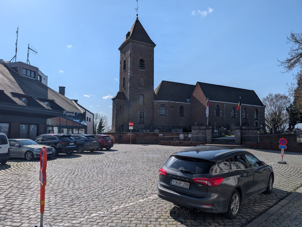
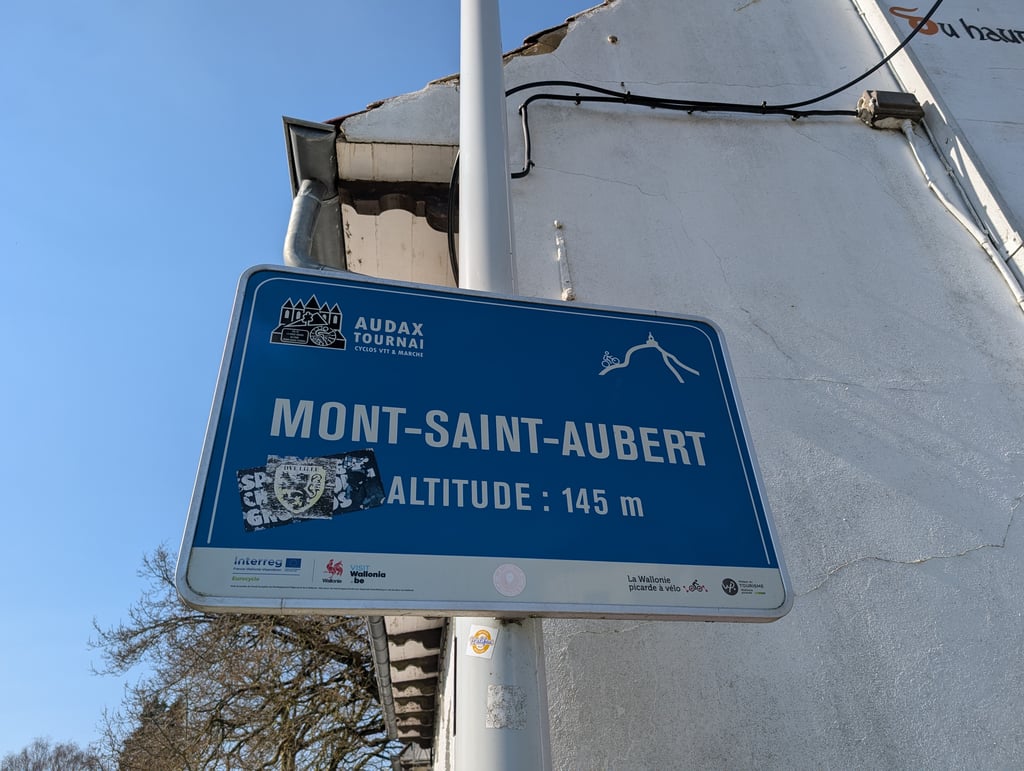
Mont Saint-Aubert from Goudinière is a climb in the region Belgian Picardy. It is 1.9 mi long and bridges 364 ft of vertical ascent with an average gradient of 3.6%, resulting in a difficulty score of 61. The top of the ascent is located at 476 ft above sea level. Climbfinder users shared 2 reviews of this climb and uploaded 5 photos.

Road names: Rue Guerbion, Rue du Bourdeau, Avenue du Rinval & Rue du Curé

3.0 by Maikel1989
This is an automatic translation, the original language is: Dutch.
Starts rolling but gradually gets steeper. Never gets really super steep. It is usually quiet, although it can be busy at the top at weekends. Nice climb to do.... read more

Photos (5)

Mont Saint-Aubert from Goudinière
transparant thumb

Your uploads (max 4)

Welcome! Please activate your account if you would like to share something. Look for the verification email in your inbox.

If you want to upload your photos, you need to create an account. It only takes 1 minute and it's completely free.

  • Receive free climbfinder goodies for your reviews & photos.
  • Create a bucket list and check off conquered climbs.
  • Add missing climbs.
Continue with GoogleContinue with Google Continue with FacebookContinue with Facebook Continue with AppleContinue with Apple Sign up with email
By signing up you agree to our terms of service and confirm that you have read our privacy & content policy.

Reviews (2)

5.0
4.0
3.0
2.0
1.0
Maikel1989
1 y 3.0
This is an automatic translation, the original language is: Dutch. Show original

Starts rolling but gradually gets steeper. Never gets really super steep. It is usually quiet, although it can be busy at the top at weekends. Nice climb to do.

Begint glooiend maar wordt langzaamaan steiler. Wordt nooit echt super steil. Het is er doorgaans rustig, bovenaan kan het in het weekend wel druk zijn. Mooie klim om te doen.

Dashboard
Franck_Pastor
4 y 3.0
This is an automatic translation, the original language is: French. Show original

The "northern slope" of Mount Saint-Aubert, very rolling up to the Croix-Jubaru pass, where it joins the classic, much steeper route to the top of the mountain.

This side, limited to the pass, is often the final ascent of the Grinta Challenge, which of course increases its difficulty.

Le « versant nord » du mont Saint-Aubert, très roulant jusqu'au col de la Croix-Jubaru, où il rejoint l'itinéraire classique, nettement plus pentu, vers le sommet du mont.

Ce versant, limité au col, est souvent l'ascension finale du Grinta Challenge, ce qui bien sûr en augmente la sensation de difficulté.

Dashboard

Climbing times

5 mph 00:23:10
7 mph 00:16:24
9 mph 00:12:47
12 mph 00:09:36

Road surface condition

33% 33% 33%
Based on 3 votes
Share your knowledge. What was the road condition during your ascent?

Traffic

67% 0% 33%
Based on 3 votes
Your experience counts. How much traffic did you encounter during the climb?

Frequently Asked Questions

You don't need special gearing for Mont Saint-Aubert from Goudinière. The slope isn't long or steep enough to require much shifting down. You can conquer this climb on power alone. However, a compact gearing system with a smallest front chainring of 34 and largest rear sprocket of 28 or 30 is always nice if you enjoy cycling uphill. This helps maintain a smooth cadence.

Mont Saint-Aubert from Goudinière falls into the 5th category. With good fitness, you can ride it up with speed and power. If you have less training, shift down and climb smoothly.

Mont Saint-Aubert from Goudinière is 1.9 mi long.

The average gradient of Mont Saint-Aubert from Goudinière is 3.6%.

Mont Saint-Aubert from Goudinière has a steepest segment with an average gradient of 9.7%.

The summit of Mont Saint-Aubert from Goudinière is at 476 ft.

At a slow pace of 5 mph, it takes about 00:23:10 to climb Mont Saint-Aubert from Goudinière. At 7 mph the time is 00:16:24, and at 9 mph 00:12:47. For the fastest cyclists, 00:09:36 is an achievable time.

Mont Saint-Aubert from Goudinière is located in the region Belgian Picardy in Belgium.

This page is better in the app

Climbfinder app
Climbfinder
(Free)
Open