View on map
© MapLibre | OpenStreetMap contributors
1%
2%
4%
6%
8%
10%
12%
15%
20%

Mont Gaillard from Aubengue

2.5
2 reviews | Elevation profile | 7 photos
Tips nearby
Mont Gaillard from Aubengue
transparant thumb
Your achievable time
Calculating based on your best performances...
Relaxed
Maximum
W/kg
W/kg
W/kg
Analyze your climbing performance
Detailed insight into your climbing performance & automatically check off climbs
Based on your best performances.
Your best attempt:
Number of attempts:
Elevation profile Mont Gaillard from Aubengue

Statistics

Difficulty points 31
Length 0.8 mi
Average gradient 3.9%
Steepest segment 9.5%
Total ascent 174 ft
Feedback about this climb?
Show climbs nearby Export to GPS device

Mont Gaillard from Aubengue is a climb in the region Caps et Marais d'Opale. It is 0.8 mi long and bridges 174 ft of vertical ascent with an average gradient of 3.9%, resulting in a difficulty score of 31. The top of the ascent is located at 236 ft above sea level. Climbfinder users shared 2 reviews of this climb and uploaded 7 photos.

Road names: Route d'Aubengue
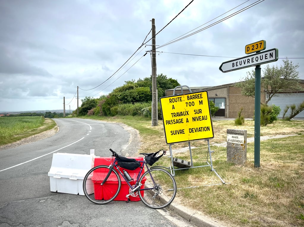
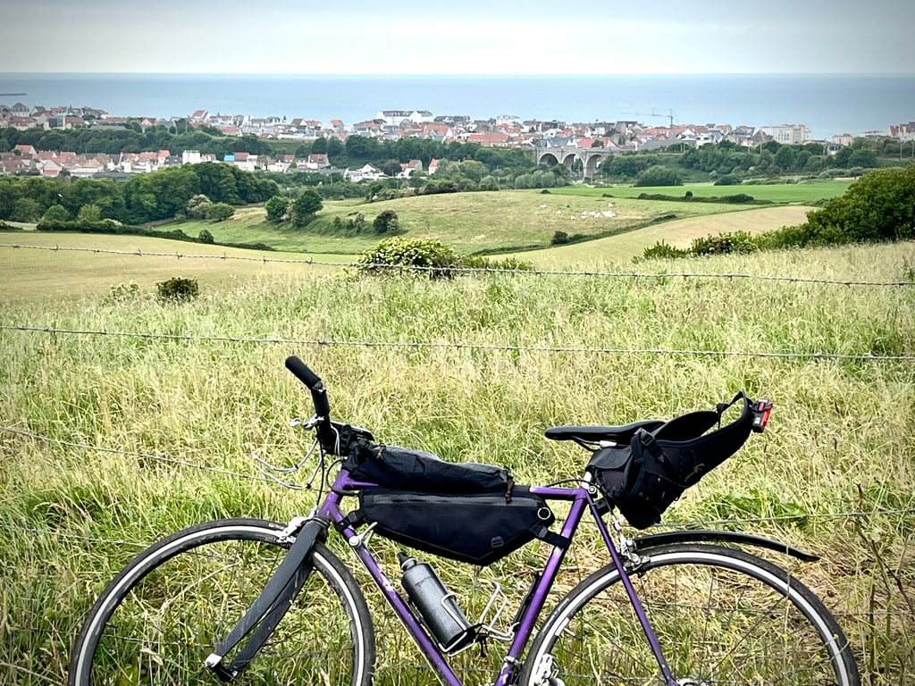
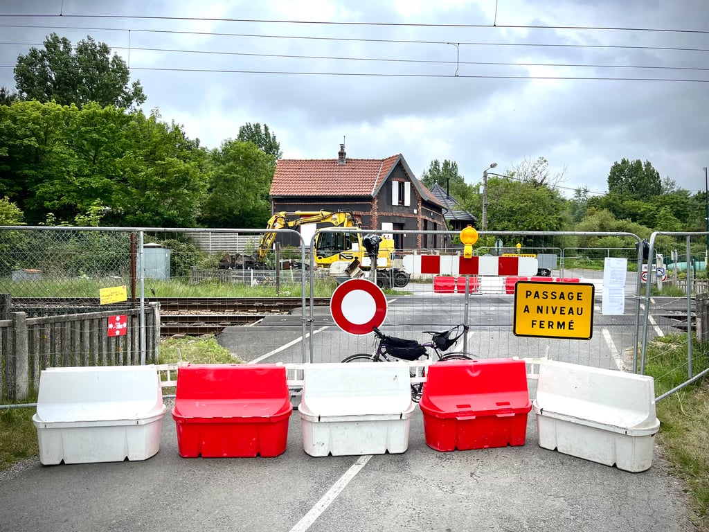
2.0 by Cromagnon
This is an automatic translation, the original language is: French.
With the level crossing under construction, you can only climb the last half of this hill. That's okay, it's the part with a bit of a gradient. Well, in any case, it's a climb without much interest and I don't know what I would have been able to photograph if it hadn't been for the roadworks signs. A decent route that briefly reaches 10%. From Mont Gaillard there is a view of the sea. The cemetery side is more interesting.... read more

Photos (7)

Mont Gaillard from Aubengue
transparant thumb
transparant thumb
transparant thumb
transparant thumb
transparant thumb

Your uploads (max 4)

Welcome! Please activate your account if you would like to share something. Look for the verification email in your inbox.

If you want to upload your photos, you need to create an account. It only takes 1 minute and it's completely free.

  • Receive free climbfinder goodies for your reviews & photos.
  • Create a bucket list and check off conquered climbs.
  • Add missing climbs.
Continue with GoogleContinue with Google Continue with FacebookContinue with Facebook Continue with AppleContinue with Apple Sign up with email
By signing up you agree to our terms of service and confirm that you have read our privacy & content policy.

Reviews (2)

5.0
4.0
3.0
2.0
1.0
Cromagnon
1 y 2.0
This is an automatic translation, the original language is: French. Show original

With the level crossing under construction, you can only climb the last half of this hill. That's okay, it's the part with a bit of a gradient. Well, in any case, it's a climb without much interest and I don't know what I would have been able to photograph if it hadn't been for the roadworks signs. A decent route that briefly reaches 10%.
From Mont Gaillard there is a view of the sea. The cemetery side is more interesting.

Le passage à niveau étant en travaux, on ne peut grimper que la dernière moitié de cette côte. Pas grave, c’est la partie qui propose les pourcentages sérieux. Bon, dans tous les cas, c’est une ascension sans grand intérêt visuel et je ne sais pas ce que j’aurais pu photographier s’il n’y avait pas eu les panneaux des travaux. Une route correcte qui atteint brièvement les 10%.
Depuis le Mont Gaillard, on a une vue sur la mer. Le côté cimetière est plus intéressant.

Mont Gaillard from Aubengue
Dashboard
Leon
4 y 3.0
This is an automatic translation, the original language is: Dutch. Show original

If you choose not to go via Wimereux, but to head a little more inland towards Boulogne-sur-Mer, you will encounter Mont Gaillard. It really starts to climb after the railroad crossing, from where it goes up for 400 meters to the top to slowly go down again. If your final destination is Boulogne-sur-Mer or a stop on a terrace, this is the moment to test the explosiveness of your cycling companions. Although the slope briefly touches the 10% mark, the steep part is short enough to give you a good run for your money.

Wanneer je er voor kiest niet via Wimereux, maar iets meer land inwaarts richting Boulogne-sur-Mer te rijden, kom je de Mont Gaillard tegen. Het begint pas echt te klimmen na de spoorweg overgang, vanwaar het 400 meter echt goed omhoog gaat om richting de top langzaam weer wat af te vlakken. Mocht Boulogne-sur-Mer de eindbestemming zijn of een tussenstop op het terras, is dit het moment om de explosiviteit van je fietskompanen eens uit te testen. Hoewel de helling de 10% heel even aantikt, is het steile stuk kort genoeg om eens flink door te trekken.

Dashboard

Climbing times

5 mph 00:10:08
7 mph 00:07:10
9 mph 00:05:35
12 mph 00:04:12

Road surface condition

100% 0% 0%
Based on 1 vote
Share your knowledge. What was the road condition during your ascent?

Traffic

100% 0% 0%
Based on 1 vote
Your experience counts. How much traffic did you encounter during the climb?

Frequently Asked Questions

Mont Gaillard can be cycled from 2 sides. Rue du Cimetière from Wimille is the most popular side, but the summit can also be reached via Mont Gaillard from Aubengue.

You don't need special gearing for Mont Gaillard from Aubengue. The slope isn't long or steep enough to require much shifting down. You can conquer this climb on power alone. However, a compact gearing system with a smallest front chainring of 34 and largest rear sprocket of 28 or 30 is always nice if you enjoy cycling uphill. This helps maintain a smooth cadence.

Mont Gaillard from Aubengue falls into the 5th category. With good fitness, you can ride it up with speed and power. If you have less training, shift down and climb smoothly.

Mont Gaillard from Aubengue is 0.8 mi long.

The average gradient of Mont Gaillard from Aubengue is 3.9%.

Mont Gaillard from Aubengue has a steepest segment with an average gradient of 9.5%.

The summit of Mont Gaillard from Aubengue is at 236 ft.

At a slow pace of 5 mph, it takes about 00:10:08 to climb Mont Gaillard from Aubengue. At 7 mph the time is 00:07:10, and at 9 mph 00:05:35. For the fastest cyclists, 00:04:12 is an achievable time.

Mont Gaillard from Aubengue is located in the region Caps et Marais d'Opale in France.

This page is better in the app

Climbfinder app
Climbfinder
(Free)
Open