View on map
© MapLibre | OpenStreetMap contributors
1%
2%
4%
6%
8%
10%
12%
15%
20%

Mechels Bos via Steenweg naar As

2.0
2 reviews | Elevation profile | 9 photos
Tips nearby
Mechels Bos via Steenweg naar As
Your achievable time
Calculating based on your best performances...
Relaxed
Maximum
W/kg
W/kg
W/kg
Analyze your climbing performance
Detailed insight into your climbing performance & automatically check off climbs
Based on your best performances.
Your best attempt:
Number of attempts:
Elevation profile Mechels Bos via Steenweg naar As

Statistics

Difficulty points 8
Length 1.9 mi
Average gradient 1.5%
Steepest segment 3.1%
Total ascent 144 ft

Short recap

#45 toughest climb of Kempens Plateau
#75 most elevation gain of Belgium Limburg
#49 longest climb of Flanders
Feedback about this climb?
Show climbs nearby Export to GPS device

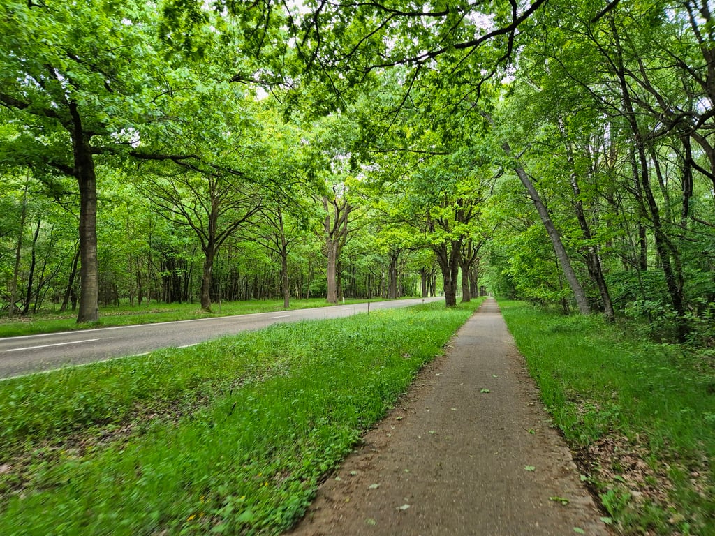
Mechels Bos via Steenweg naar As is a climb in the region Kempens Plateau. It is 1.9 mi long and bridges 144 ft of vertical ascent with an average gradient of 1.5%, resulting in a difficulty score of 8. The top of the ascent is located at 295 ft above sea level. Climbfinder users shared 2 reviews of this climb and uploaded 9 photos.

Road names: Joseph Smeetslaan & Steenweg naar As

1.0 by _superver
This is an automatic translation, the original language is: Dutch.
Not very difficult. Bike path is clear, which is nice. It is also fine surface. You do hear and see the cars. Would never make a special detour for it and there are nicer alternatives in the area too.... read more

Photos (9)

Mechels Bos via Steenweg naar As
transparant thumb
transparant thumb
transparant thumb

Your uploads (max 4)

Welcome! Please activate your account if you would like to share something. Look for the verification email in your inbox.

If you want to upload your photos, you need to create an account. It only takes 1 minute and it's completely free.

  • Receive free climbfinder goodies for your reviews & photos.
  • Create a bucket list and check off conquered climbs.
  • Add missing climbs.
Continue with GoogleContinue with Google Continue with FacebookContinue with Facebook Continue with AppleContinue with Apple Sign up with email
By signing up you agree to our terms of service and confirm that you have read our privacy & content policy.

Reviews (2)

5.0
4.0
3.0
2.0
1.0
_superver
1 y 1.0 via the Climbfinder app
This is an automatic translation, the original language is: Dutch. Show original

Not very difficult. Bike path is clear, which is nice. It is also fine surface. You do hear and see the cars. Would never make a special detour for it and there are nicer alternatives in the area too.

Niet heel moeilijk. Fietspad ligt vrij, dat is mooi. Het is ook prima ondergrond. Je hoort en ziet de auto’s wel. Zou er nooit speciaal voor omrijden en ook in de omgeving zijn er leukere alternatieven.

Dashboard
Fedor
3 y 3.0
This is an automatic translation, the original language is: Dutch. Show original

A long climb on a separate cycle path next to a through road. The road is not too busy and the cycle path is often a few metres from the road so that the traffic does not bother you too much. The cycle path clearly undulates more than the road next to it so there are continuous steeper sections and sometimes small descents. This makes the climb a lot harder than what the profile suggests. Beautiful wooded surroundings.

Een lange klim over een vrijliggend fietspad naast een doorgaande weg. De weg is niet al te druk en het fietspad ligt vaak enkele meters van de weg dus veel last van het verkeer heb je niet. Het fietspad golft duidelijk meer dan de weg er naast dus er zijn continue steilere stukjes en soms kleine afdalingen. Dat maakt de klim een stuk zwaarder dan wat het profiel suggereert. Mooie bosrijke omgeving.

Mechels Bos via Steenweg naar As
Dashboard

Climbing times

5 mph 00:22:32
7 mph 00:15:57
9 mph 00:12:26
12 mph 00:09:20

Road surface condition

0% 0% 0%
Based on 0 votes
Share your knowledge. What was the road condition during your ascent?

Traffic

0% 0% 0%
Based on 0 votes
Your experience counts. How much traffic did you encounter during the climb?

Frequently Asked Questions

You don't need special gearing for Mechels Bos via Steenweg naar As. The slope isn't long or steep enough to require much shifting down. You can conquer this climb on power alone. However, a compact gearing system with a smallest front chainring of 34 and largest rear sprocket of 28 or 30 is always nice if you enjoy cycling uphill. This helps maintain a smooth cadence.

Mechels Bos via Steenweg naar As is not tough enough to be assigned a mountain category. This means that even untrained cyclists can reach the top without any problems on this climb.

Mechels Bos via Steenweg naar As is 1.9 mi long.

The average gradient of Mechels Bos via Steenweg naar As is 1.5%.

Mechels Bos via Steenweg naar As has a steepest segment with an average gradient of 3.1%.

The summit of Mechels Bos via Steenweg naar As is at 295 ft.

At a slow pace of 5 mph, it takes about 00:22:32 to climb Mechels Bos via Steenweg naar As. At 7 mph the time is 00:15:57, and at 9 mph 00:12:26. For the fastest cyclists, 00:09:20 is an achievable time.

Mechels Bos via Steenweg naar As is located in the region Belgium Limburg in Belgium.

This page is better in the app

Climbfinder app
Climbfinder
(Free)
Open